Company Registration No.: 201119605N 35 Hougang Avenue 7#04-07Singapore (569880) www.usp-pl.com
—— ONLINE FIRST
(NOT Peer-Reviewed)
——
Title: Simulation and Optimization for the Urban Transport
Infra-structure
Received: 2019-03-18
Online First: 2019-03-18
Process: I. First trial (Field and check)
II. Peer review
III. Editing and three trials
IV. Published online
Simulation and Optimization for the Urban Transport Infrastructure
ABSTRACT: The urban transport infrastructure is one of the most important problems for the cities, and involves many aspects that concern to citizens, governments and the economic growth of the countries. The objective of this paper is to show how this issue has been studied in recent years, with emphasis in the use of simulation and optimization at the whole planning process. We also consider the important key topics as sustainability, costs and risks, mobility and environment impact. Some study cases are shown to clarify the concepts presented.
Key words: Urban transport, planning, simulation, optimization.
1. Introduction
Nowadays one of the bigger problems in cities is the transportation system and its infrastructure. There have been lots of studies and research in recent decades trying to find solutions. In general, there is an economic impact when countries make an investment in this sector. Most of the studies on transport infrastructure, in particular, focuson its impact on growth. In the past two decades, the analytical literature has grown enormously, with studies carried out using different approaches, such as a production function (or cost) and growth regressions, as well as different variants of these models (using different data, methods and methodologies), the majority of these studies found that transportation infrastructure has a positive effect on output, productivity or growth rate Calderon & Serven (2008). One of the pioneers was Aschauer (1991) who, in his empirical study, provided substantial evidence that transport is an important determinant of economic performance. Another example is the study of Alminas, Vasiliauskas and Jakubauskas (2009), who found that transport has contributed to growth in the Baltic region. Another study on the Spanish plan to extend roads and railways that connect Spain with other countries concludes that these have a positive impact in terms of Gross Domestic Product (GDP) Alvarez-Herranz & Martínez-Ruiz (2012). In a study of the railroad in the United States, it is mentioned that many economists believe that the project costs exceed the benefits Balaker (2006). However, the traditional model of cost-benefit assessment does not include the impact of development projects De Rus (2008). In these studies, focused on growth, we see there is a bias towards economic rather than social goals. That is why it is important to emphasize the impact of transport infrastructure on development and not just growth.
Some papers that deal with economical and social impact are shown here.
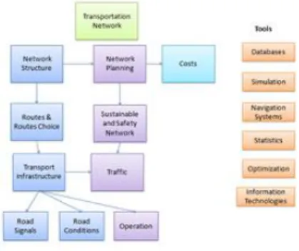
In order to show the subject clearly, we will use a systems approach, dividing urban transport infrastructure according to The City of Calgary (2009)
Urban Transport infrastructure:
•Transportation Planning
•Transportation Optimization
•Transportation Simulation
According to this system paradigm, this paper is focused on the description of the research made in the last five years, mainly considering optimization, and simulation and the intelligent systems. The structure of this paper is as follows. Section 2 shows the state of the art for the general transportation planning issue. Section 3 is devoted to transportation optimization. Section 4 shows some simulation tools that have been used in different ways in accordance with the problems they are meant to solve. Section 5 is devoted to some cases in different cities around the world. Short conclusions are given at the end of the paper.
2.
Transportation Planning
Transportation planning covers a lot of different aspects and is an essential part of the system. According with
1Universidad Nacional Autónoma de México
Apdo. Postal 70-256 Cd. Mx. 04360 [email protected]
2Universidad Nacional Autónoma de México
Apdo. Postal 70-256 Cd. Mx. 4360 [email protected]
.
Levy (2011)
“Most regional transport planners employ what is called the rational model of planning. The model considers planning as a logical and technical process that uses the analysis of quantitative data to decide how to best invest resources in new and existing transport infrastructure.”
2.1 Phases for transportation planning
There are three phases: The first, pre-analysis, considers what problems and issues the region faces and what goals and objectives it can set to help address those issues. The second phase is technical analysis. The process basically involves the development of the models that are going to be used later. The post-analysis phase involves plan evaluation, program, implementation and monitoring of the results, Johnston (2004).
Transportation planning involves the following steps:
• Monitoring existing conditions;
• Forecasting future population and employment growth, including assessing projected land uses in the region and identifying major growth corridors;
• Identifying current and projected future transportation problems and needs and analyzing, through detailed planning studies, various transportation improvement strategies to address those needs;
• Developing long-range plans and short-range programs of alternative capital improvement and operational strategies for moving people and goods;
• Estimating the impact of recommended future improvements to the transportation system on environmental issues, including air quality; and
• Developing a financial plan for securing sufficient revenues to cover the costs of implementing strategies. In order to consider these aspects is important to study them into an urban infrastructure scope.
2.2 Urban Infrastructure
Urban infrastructure, a human creation, is designed and directed by architects, civil engineers, urban planners among others. These professionals design, develop and implement projects (involved with the structural organization of cities and companies) for the proper operation of important sectors of society. When governments are responsible for construction, maintenance, operation and costs, the term “urban infrastructure” is a synonym for public works.
Road infrastructure is the set of facilities and equipment used for roads, including road networks, parking spaces, traffic lights, stop signs laybys, drainage systems, bridges and sidewalks.
Urban infrastructure includes transportation infrastructure, which can, in turn, be divided into three categories: land, sea, and air, they can be found in the following modalities:
•
Street networks, high or low-speed railway lines, together with such as bus stops, road signs, traffic lights, parking bays, and so forth. This applies to all the cases cited below:•
Infrastructure for mass transit or bike paths and footpaths•
Canals, bridges•
Ports, airports and lighthouses, etc.Some papers published concerning transport planning are as follows:
Planning local public transport: a visual support to decision making, Stefano Pensa et al.(2014)
The paper focuses on the visualization system, as GIS applications. One of the tools is the Visual TPL (Public Transport in Italy) tool has been designed to be used by experts in planning and evaluation of transport systems with the purpose of identifying the critical points which could be studied in order to rationalize them and reduce the burden on the public purse. This tool along with maps and other features helps the analyses planners.
Introduction to Multi-Modal Transportation Planning Principles and Practices, Todd Litman (2012)
This paper summarizes basic principles for transportation planning. It describes conventional transport planning, which tends to focus on motor vehicle traffic conditions, and newer methods for more multi-modal planning and evaluation.
The Research on Practical Approach for Urban Transport Planning.
This study developed by JICA (The Japan International Cooperation Agency) is the result of a huge experience in more than 60 countries, and its purpose is to contribute to the formulation of medium-to long-term development
strategies for urban transport. A schema is shown next:
Fig. 1. Guidelines for formulating an urban transport strategy (Source JICA)
Based on the transportation planning issues, tools as optimization and simulation have been widely used to solve them, as it is shown in next sections.
3.
Transportation Optimization
The goal of transportation optimization is to identify, evaluate and plan enhancements that optimize the operation of a transportation system. With this in mind, many countries have specific policies for this and a lot of research has been developed over recent years to this end. Optimization deals mainly with networks operation, traffic, costs, maintenance, sustainability, mobility and management infrastructure. These aspects require balance between the performance of the structure and the total cost accrued over the entire life-cycle.
For instance, in Worm and Harten (1996), the authors developed a Decision Support Model.
“This model is a tool for the road manager to assist in generating an optimal maintenance plan for a road. Optimal means: minimizing the Net Present Value of maintenance costs, while the plan is acceptable in terms of technical admissibility, resulting quality, etc. Global restrictions such as budget restrictions can also be imposed.”
There is a site that considers some principles for transportation optimization (http://www.jda.com/)
“With the transportation management system market expanding, the time has come to clarify misperceptions and reveal the best practices in optimization. The Transportation Management System Investment must optimize beyond carrier selection and rates to address myriad constraints and granular functions that apply these three key principles:
1.
One size does not fit all2.
The details matter3.
Concurrency is king”.In Multicriteria decision making for sustainability evaluation of urban mobility projects Anjali Awasthi (2013), authors investigated the use of multicriteria decision making techniques for sustainability evaluation of urban mobility projects, taking into account an integration of the triple bottom line concept i.e., achievement of social, economical and environmental objectives with technical efficiency for evaluating urban mobility projects through the use of multicriteria decision making (MCDM) techniques. For sustainability evaluation of urban mobility projects under qualitative data, authors also showed an application of these tools.
The transport issues can be seen as a transportation network, and in this way the relationships among the main elements to analyze and study, figure 2 shows these ideas.
Figure 2 Transportation network by valid inequalities.
In the case of networks, some routing studies have been developed using either genetic algorithms hybridized with Dijkstra algorithms to find the shortest routes, or just some advanced label algorithms as the one shown in Klunder,
.
(2006).
As has already been mentioned, metaheuristics are used because they provide very good solutions in a short time, like the neural networks that are used by Yu et al (2011). However other authors use exact methods as branch and bound, branch and cut, or dynamic programming. The location and routing problem presented by Belenguer et al (2011) uses branch and cut for the design of logistic networks. In this case the overall distribution cost may be excessive if routing decisions are ignored when locating depots. In order to overcome this problem, they propose a branch and cut algorithm for solving it. The proposed method is based on a zero-one linear model reinforced by valid inequalities.
Berman et al (2011) gives us an example of search paths for service. In this paper an optimal search path is found for a service problem that is stated as follows: “A customer residing at a node of a network needs to obtain service from one of the facilities; facility locations are known and fixed. Facilities may become non operational with certain probability; the state of the facility only becomes known when the facility is visited. Customer travel stops when the first operational facility is found. The objective is to minimize the expected total travel distance”. This problem is NP-hard and a forward dynamic programming procedure is developed.
Considering objective optimization, there is the paper of Wanga et al. (2014) and proposed a bilevel multi-objective approach to optimize tolls in a road network.
“Consider three objectives at the upper level: minimizing system travel time; total vehicle emissions; and negative health impacts, modeled as the level of pollutant uptake”.
Another paper related to multi-objective is the one of Guerreiro et al. (2014).
“In the Dial-a-Ride public transportation systems, each customer requirement is specified in terms of a pickup (origin), of a delivery (destination) and of a time window within it has to be satisfied. The aim is to find a set of routes, each assigned to a vehicle, in order to satisfy the set of requests, under capacity, time windows, precedence and pairing conditions. This paper addresses the problem with the aim of optimizing, at the same time, the maximum total ride time and the total waiting time. Then, a bi-objective Pickup and Delivery Problem with Time Windows (PDPTW) with a constraint on the maximum duration of each route is proposed and solved by a two-step approach.”
Fancello et al. (2014) developed an integrated performance indicator in urban road infrastructure for evaluating network functionality and the impact of transport system interventions. The complex indicator has been elaborated using a multicriteria algorithm, based on concordance analysis.
An interesting application for the optimization users is the one presented by Spiliopoulou et al. (2014) authors validate a macroscopic traffic flow model.
“The reported study tests, validates and compares two well-known macroscopic traffic flow models in the special, but quite frequently occurring case, where congestion is created due to saturated freeway off-ramps. In particular, the comparison includes the first-order model CTM (Cell Transmission Model) and the second-order model METANET.”
Authors used real traffic data from Attiki Odos freeway in Athens, Greece.
Travel time in a network is different in public and private transport, for this reason Salonen and Toivonen (2013). They assume that the analysis of the accessibility disparity between different travel modes is recognized as an efficient way to assess the environmental and social sustainability of transport and land use arrangements. They also mention, and are quoted:
“This paper aims to assess the comparability of different methods for calculating travel time by different travel modes. First, we briefly review the methods used in previous studies and identify different typical approaches, which we then compare. We use three computational models respectively for car and public transport (PT), implemented in our case study area, the capital region of Finland.”
Chow et al., A network option portfolio management framework for adaptive transportation planning (2011) declare that:
“A number of attempts at incorporating uncertainty in network design and investment models have been considered, although stochastic demand and capacity are generally dealt with using stationary, static distributions with scenario planning approaches”
What it is indisputably true. Then in their paper it can be found that on the transportation network option portfolio management framework is a dynamic decision-support tool for adapting multiple network investment and design
decisions over time, for this reason a truly flexible planning approach requires consideration of multiple periods and adaptive decision-making which is essentially stochastic dynamic programming.
For example, a planning agency that adopts this framework would identify an optimal set of decisions for each design element using the ANDP (adaptive decision maker base on dynamic programming) every year, either to continue an investment strategy or to stop that strategy. The agency would also make use of the information provided in the option space to determine which options may require further attention. Over the next year, the agency would gather new data, update their stochastic variables, and re-run the ANDP and update the portfolio option space. An application of this methodology was used with an insertion heuristic to run the lower bound adaptive network design problem for a coarse Iran network with 834 nodes, 1121 links, and 10 years of time series data for 71,795 OD pairs.
The maintenance of urban infrastructure consists of a series of actions that require knowledge and experience about the needs of different types of infrastructure (bus stops, signage, benches etc.) to be done in the optimum manner. To achieve this, infrastructure can be changed, expanded and/or replaced in an efficient manner in order to meet the needs of the users of a city.
Other papers about maintenance that uses other techniques that are not in optimization are:
There is a paper titled Sustainable roadway construction using recycled aggregates with geosynthetics. Hana, and Thakur (2014). In this paper authors explain the use of new material for maintenance since concrete, asphalt pavements, and ballast are removed during the re- construction of existing roads and have been increasingly recycled as aggregates for the construction of roadways. As they explain:
“This paper reviews recent research work on the use of geosynthetics to stabilize recycled aggregates in roadway construction and summarizes the main findings on permanent deformation, creep deformation, degradation, stress distribution, and/or crack propagation.”
Eco-burden in pavement maintenance: Effects from excess traffic growth and overload Corinthias et al. (2014). This study investigates the eco-burden effect of road construction in its maintenance phase along with the influence of above factors in shortening road life-cycle. Because of that, life-cycle assessment (LCA) is used to calculate the eco-burden impact. Furthermore, they are two different options taken for pavement materials: hot-mix and recycled asphalt. They are compared in order to provide comprehensive investigation results for decision makers.
4. Transportation Simulation
As it was been shown in the previous section, optimization is a good tool for the operation system, and is helpful when minimizing costs or time, selecting routes and decision problems related to the budget, to mention some. As it was mentioned before, data in transportation is not always deterministic but stochastic, in such cases simulation is helpful and is an analysis tool that helps to answer kind of questions what if?It is also helpful to construct scenarios and to choose the one that fits better to our needs.
Some papers are presented here where simulation was used:
A micro-simulation related with trips consider single data and census data, Lovelace et al. (2014), studied the statistics on mode and distance of travel, which vary depending on a range of factors that operate at different scales. With this problem in mind they proposed “a spatial micro-simulation approach, which combines individual-level survey data with geographically aggregated census results to tackle theproblem.”
Integration of the urban public transportation system with the application of traffic simulation, Solecka and Żak (2014). In this paper authors present a methodology of designing and assessment of transportation solutions that result in the integration of an urban public transportation system. The proposed approach is based on the application ofheuristic–expertdesignofanintegratedurbanpublictransportationsystem,itssimulation with the use of a computer-based macro-simulation system VISUM and its multidimensional – multiple parameter comparison with the existing solution. The article describes in detail all the steps to be taken when applying the proposed procedure that leads to the development of an integrated public transportation system.
SUMO – Simulation of Urban Mobility. An Overview, Behrisch et al. (2011) SUMO is an open source traffic simulation package including net import and demand modeling components. Authors describe the current state of the package as well as future developments and extensions. SUMO helps to investigate several research topics eg. A route choice and traffic light algorithm or simulating vehicular communication. There for the framework is used in different projects to simulate automatic driving or traffic management strategies.
.
http://www.simulatorcentral.com/index.php/simulators/transport.html http://www.simutrans.com/en/ http://www.aimsun.com/wp/ http://www.caliper.com/transmodeler/
For traffic, some of them are: Paid: Traffic flow simulators:
-
Quadstone paramics(microscopic)-
VISSUM(macroscopic)-
VISSIM(microscopic)-
AIMSUN Free:-
Matsim-
SUMO(microscopic)-
Repast-
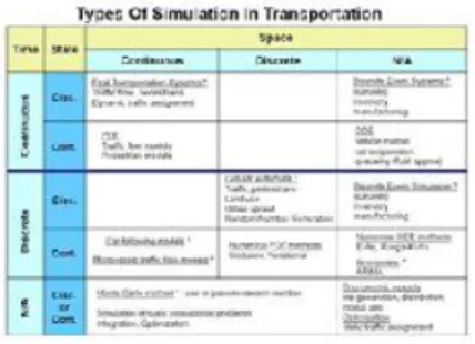
MAINSIMThere are also general-purpose discrete simulation software packages such as SIMIO, Promodel or Flexim, as well as other more specific packages, such as S Paramics, or Simleader. A transport simulation table shows different types of simulation in this area.
Table 1 Transport simulation.
Source https://upload.wikimedia.org/wikipedia/commons/7/71/Simulation_Table.JPG
5.
Cases using simulation and optimization.
Linear Bus Holding Model for Real-Time Traffic Network Control, Hernández- Landa, et al.(2015)
One of the most annoying problems in urban bus operations is bus bunching, which happens when two or more buses arrive at a stop nose to tail. Bus bunching reflects an unreliable service that affects transit operations by increasing passenger-waiting times. This work proposes a linear mathematical programming model that establishes bus holding times at certain stops along a transit corridor to avoid bus bunching. Authors refer that the approach needs real-time input, so they simulate a transit corridor and apply the proposed mathematical model to the data generated. Thus, the inherent variability of a transit system is considered by the simulation; while the optimization model takes into account the key variables and constraints of the bus operation. This methodology reduces overall passenger-waiting times efficiently given the linear programming model, with the characteristic of applying control intervals just every 5 minutes. Figure 3 shows a framework for this situation.
Fig. 3 Framework for interleaving optimization (BBP LP modeling) and real time data retrieving (or simulation). Source Hernández Landa et. al (2015)
Hazardous materials network design based on management restrictions, López, Carmona and Segura(2015). This research is about a real-life problem for the design of an opening hazardous material distribution network. The problem presents a high degree of complexity, mostly because both capital expenditures (CAPEX) and operating
expenses (OPEX) play a major role in the feasibility of the venture. CAPEX includes buying machinery, acquiring permissions, and investment in transport vehicles (fleet size), whereas OPEX involves the transportation of a hazardous material to the customers. The objective of the proposed mathematical model is to minimize CAPEX and OPEX to offer customers a better price. The objective function considers the cost of opening a supply center, the transportation costs and buying/renting vehicles for a planned time horizon.
For the case study, the coordinates (locations) and daily consumption in [u] units shipped during the contract period of 6 customers and 3 supply locations were given by a Mersenne Twister. The distance between locations corresponds to the straight-line length between their coordinates. Supply center locations are where processing equipment can be installed considering opening costs. The solution includes choosing at least one supply center, determining the fleet size and specifying the transport routes. The map of the case study scenario is shown in Figure 4:
Fig. 4 Supply centers and customer locations with demands
Acknowledgments
The authors would like to thank the PAPIIT-DGAPA project IT102117, UNAM.