ScholarWorks @ Georgia State University
ScholarWorks @ Georgia State University
Anthropology Theses Department of Anthropology
Spring 5-15-2011
Middle Bronze Age- Late Bronze Age Transitions in the Southern
Middle Bronze Age- Late Bronze Age Transitions in the Southern
Urals (Russia). Case Study: Shifts in Settlement Patterns in the
Urals (Russia). Case Study: Shifts in Settlement Patterns in the
Kyzil Area, Chelyabinsk District.
Kyzil Area, Chelyabinsk District.
denis sharapov
Georgia State University
Follow this and additional works at: https://scholarworks.gsu.edu/anthro_theses
Part of the Anthropology Commons
Recommended Citation Recommended Citation
sharapov, denis, "Middle Bronze Age- Late Bronze Age Transitions in the Southern Urals (Russia). Case Study: Shifts in Settlement Patterns in the Kyzil Area, Chelyabinsk District.." Thesis, Georgia State University, 2011.
https://scholarworks.gsu.edu/anthro_theses/51
STUDY: SHIFTS IN SETTLEMENT PATTERNS IN THE KYZIL AREA, CHELYABINSK DISTRICT.
by
DENIS SHARAPOV
Under the Direction of Jeffrey Glover
ABSTRACT
The following paper focuses on the transitional period between the Middle Bronze Age (MBA) and the
Late Bronze Age (LBA) in the Southern Urals, Russia. GIS-based analysis of Bronze Age settlement
patterns in the Kyzil Area points to a number of important findings. The study concludes the
demographic impossibility of an autonomous development scenario of the Sintashta – Srubnaya-Alakul
cultural transformation, rejects the presence of ‘proto-city’ or urbanization developments in the region
during the Bronze Age, and points to the shift to a more collective form of control over natural resources
during the LBA period. The study also examines the spatial distribution of ‘kurgan’ cemeteries in the
area. Among other things, this thesis illustrates how settlement pattern studies can add to and
complement the heavily burial data - driven research, often relied upon in the archaeological analysis of
the Eurasian Steppes.
MIDDLE BRONZE AGE – LATE BRONZE AGE TRANSITION IN THE SOUTHERN URALS (RUSSIA). CASE
STUDY: SHIFTS IN SETTLEMENT PATTERNS IN THE KYZIL AREA, CHELYABINSK DISTRICT.
by
DENIS SHARAPOV
A Thesis Submitted in Partial Fulfillment of the Requirements for the Degree of
Master of Arts
in the College of Arts and Sciences
Georgia State University
Copyright by Denis Sharapov
STUDY: SHIFTS IN SETTLEMENT PATTERNS IN THE KYZIL AREA, CHELYABINSK DISTRICT.
by
DENIS SHARAPOV
Committee Chair: Jeffrey Glover
Committee: Jeffrey Glover
Zachary Hruby
Bryan Hanks
Electronic Version Approved:
Office of Graduate Studies
College of Arts and Sciences
Georgia State University
TABLE OF CONTENTS
List of Tables ... vii
List of Figures ... viii
1 Introduction ... Error! Bookmark not defined. 1.1 Purpose of the study and the expected results ... Error! Bookmark not defined. 1.2 Southern Urals: geography, ecology, and climate ... 3
2 Russian vs. American archaeology ... 7
2.1 Historical trajectories ... 7
2.1.1 North America ... 7
2.1.2 Russia ... 10
2.2 Comparison of the two schools of thought ... 13
2.3 Differences in motivations and methodological practices ... 14
2.4 Conclusion ... 17
3 Settlement pattern studies and Geographic Information Systems (GIS) ... 19
3.1 Theoretical and methodological perspectives in settlement pattern research . 19 3.2 Role of GIS in regional settlement pattern research ... 25
3.3 GIS and environmental determinism ... 28
3.4 Conclusion ... 31
4 Southern Urals during the Bronze Age ... 33
4.1 Archaeological “culture”: history and definition ... 33
4.2.1 Early Bronze Age ... 37
4.2.2 Middle Bronze Age ... 38
4.2.3 Late Bronze Age ... 42
4.3 Subsistence base and metal production in the Southern Urals ... 45
4.4 Conslusion ... 49
5 MBA - LBA transition in the Southern Urals ... 51
5.1 Prevalent hypotheses in archaeological literature ... 52
5.1.1 Archaeological culture genesis and the Sintashta-Alakul transition ... 52
5.1.2 Role of migration-diffusion processes in the MBA LBA transition ... 55
5.1.3 Climatic shifts during the Bronze Age in the Southern Urals ... 60
5.2 Role of metallurgy in shaping the Southern Urals society ... 66
5.2.1 Craft specialization and social structure ... 67
5.2.2 Metallurgists and social status in the Bronze Age ... 70
5.2.3 Spread of metallurgical knowledge during the LBA period ... 71
5.3 Conclusion ... 76
6 Case study: MBA LBA settlement patterns in the Kyzil Area, Southern Urals ... 77
6.1 Kyzil Area: geography and brief description ... 77
6.2 Data used in the case study ... 79
6.3 Case study methodology ... 80
6.3.1 GIS techniques ... 80
6.3.2 Burial vs. settlement evidence ... 86
6.5 Findings ... 89
6.5.1 Paleodemographic estimates ... 90
6.5.2 Autonomous development vs. outside influence ... 95
6.5.3 Proto-towns and the urbanization hypothesis ... 96
6.5.4 New social order: collective control over resources ... 111
6.5.5 Spatial distribution of kurgan cemeteries ... 122
7 Conclusions... 134
References ... 138
Appendices ... 150
Appendix A: Attribute data of LBA/FBA sites ... 150
List of Tables
List of Figures
Figure 1.1 Southern Urals ... 4
Figure 1.2 The Eurasian Steppes ... 5
Figure 4.1 MBA cultures of the Volgo-Urals and Western Siberia ... 39
Figure 4.2 Late Bronze Age archaeological cultures of the steppes ... 43
Figure 5.1 Seima-Turbino sites ... 73
Figure 6.1 Trans-Ural ‘peneplen’ ... 78
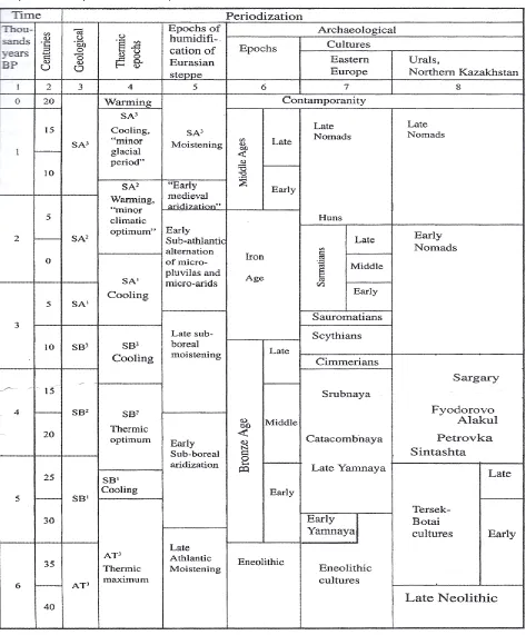
Figure 6.2 Distribution of Bronze Age settlements in the Kyzil Area ... 89
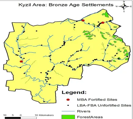
Figure 6.3 Plan of the Arkaim fortified settlement ... 99
Figure 6.4 Unrestricted peer-polity interaction sphere... 103
Figure 6.5 ‘Country of Towns’ as an unrestricted interaction sphere ... 103
Figure 6.6 LBA settlement densities and the largest LBA sites ... 107
Figure 6.7 Cumulative viewshed of LBA/FBA sites ... 108
Figure 6.8 Distribution of the MBA fortified settlements ... 114
Figure 6.9 Viewshed from the Kuysak site ... 115
Figure 6.10 Viewsheds from Kuysak and Sarim-Sakli sites ... 116
Figure 6.11 MBA Least Cost Paths (LCP’s) ... 118
Figure 6.12 Kernel Density distribution of the LBA/FBA unfortified settlements ... 120
Figure 6.13 Kernel Density of Bronze Age kurgan cemeteries ... 126
Figure 6.14 Kernel Density of Bronze Age settlements ... 126
1 Introduction
1.1 Purpose of the study and the expected results
The following paper addresses the period of transition from the Middle Bronze Age
(MBA), 2500-1800 BC, to the Late Bronze Age (LBA), 1800-1500 BC, (Koryakova and Epimakhov
2007) in the Southern Urals region of Russia (see Figure 1.1) by relying on settlement pattern
data. The Bronze Age, being a pivotal period in many aspects of the Eurasian Steppes’
prehistory, had served as a precursor to the emergence of social complexity in the region
(Renfrew 2009:XV). The MBA-LBA transition is a period characterized by significant changes in
many aspects of life for the dwellers of the steppes, in general, and of the Southern Urals
region, in particular. In culture-historical terms, the MBA Sintashta archaeological culture got
replaced by the LBA Srubnaya-Alakul cultural complex, with Petrovka cultural development
representing a transitional stage between the two (Koryakova and Epimakhov 2007). One
major change taking place in the region during this part of the Bronze Age has to do with
settlement practices. The following analysis aims to shed light on the MBA-LBA transition by
examining the changing types and locational distributions of the Southern Urals’ Bronze Age
settlements.
Most of the archaeological data dealing with the Bronze Age in the Eurasian Steppes
comes from the burial context (Kohl 2007:16), which is due in part to the historical traditions of
Russian archaeological school. The following study examines the MBA-LBA transition from a
slightly different perspective when compared to most of the archaeological literature published
on the subject to date. Examining settlement (vs. burial) evidence through employing
archaeology of the Southern Urals. The settlement pattern analysis of Bronze Age settlements
in the Southern Urals has been limited to identifying individual sites through areal photography
remote sensing technique and creating basic regional settlement distribution maps (Zdanovich
et. al 2003). Utilization of GIS, a leading interdisciplinary tool capable of interpreting, analyzing
and displaying spatial data, offers a great potential for expanding the analytical component of
the settlement pattern research in the Southern Urals. The ability of GIS’ techniques to
integrate various theoretical developments in archaeology into spatial analysis, such as
postprocessual notions of landscape phenomenology, combined with tremendous quantitative
and graphical capabilities of this digital tool, can add to our understanding of the Eurasian
Bronze Age prehistoric dynamics.
The following work compares the historical trajectories of the Russian vs. American
schools of archaeological thought; examines the changing perspectives in settlement pattern
research and GIS-based spatial analysis; outlines the overall Bronze Age dynamics in the
Southern Urals; and highlights the hypotheses put forward by other archaeologists regarding
the MBA-LBA transition in the region. Finally, this paper focuses on the Kyzil Area case study,
which employs a number of GIS-based methodologies to analyze the MBA-LBA transition from a
settlement pattern perspective.
Among the specific research questions addressed in this thesis are : the level of
directness of cultural and demographic continuity between the MBA Sintashta-Petrovka and
the LBA Srubnaya-Alakul populations through paleodemographic estimates based on
settlement evidence; the level of possible ‘proto-city’ formation or urbanization processes
natural resource distribution patterns on Bronze Age settlement location choices. Finally, the
Kyzil Area case study, outlined in chapter six of the thesis, evaluates the possible roles played
by kurgans (burial mounds) in the lives of the people of the steppes by examining the
distribution patterns of this ritual landscape component in the Kyzil Area.
1.2 Southern Urals: geography, ecology, and climate
The Southern Urals region is located in present-day southern Russia. The region
encompasses territories adjacent to the southern part of the Ural Mountain range, which
stretches through the northern part of the Eurasian continent, bordering on the West Siberian
Plain in the east and the North European Plain in the west (see Figure 1.2). Although purely
nominal in nature and lacking a distinctive boundary, the geographic area surrounding the Ural
Mountains is oftentimes referred to as “the Urals”, with the term being used in various
contexts. The term “Urals” is generally imbedded with a certain level of common geographic,
cultural, economic and historical heritage, shared by the inhabitants of the region. Although
officially, there is the Urals Federal District of Russia and the Urals Economic Region, geographic
borders of which vary, there is no clear-cut definition of what territories exactly constitute the
Urals.
The Southern Urals region, as it is defined for the purposes of the following research, is
located within the Eurasian steppe and forest-steppe ecological zones. Eurasian Steppes is the
term used to describe a continuous belt of open grasslands running through the center of the
Eurasian continent and stretching from the north of the Black Sea in the west, to Mongolia and
broad-leaved and boreal forests in the north and the deserts of Central Asia in the south (Kremenetski
2003:11). Although the Eurasian Steppes region encompasses vast expanses of land, with
different areas’ climates varying to a certain degree, overall, the climate of the steppes tends to
be semi-arid and continental, characterized by vast differences between the cold winter and
hot summer temperatures (Kremenetski 2003:11). In the Southern Urals, in particular, the
[image:15.612.74.573.241.622.2]average monthly temperatures are -15˚C in January and +20˚C in June (Chibilyov 2002).
Figure 1.1Southern Urals. Red oval denotes the location of the Southern Urals Region (adapted from Google Earth @ 2001 Europa Technologies).
The geography of the Eurasian Steppes is characterized by varied relief. Generally, the
low river valleys, flat plateaus, and low hills (Chibilyov 2002). The geography of the Southern
Urals is somewhat distinct due to a couple of factors. The region is located close to a steppe –
forest-steppe border (Zdanovich and Batanina 2007), which makes it more forested, compared
to other areas of the steppes. Also, being located in proximity to the Ural Mountain range, with
the Southern Urals steppe landscape sitting on top of an ancient mountain surface (Sygov
1968), the area may at times feature a number of hills or uneven surfaces. While the
topography of the area under study will be discussed in more detail in the subsequent sections,
it is important to note that the physical landscape of the Southern Urals is far from being a
[image:16.612.77.539.332.682.2]uniform, perfectly flat grassland, which is how some tend to picture the steppes.
The Urals, both the mountains as well as the adjacent steppes, are famous for high
concentrations of minerals, including ores (iron, copper, gold) and a variety of semiprecious
stones (jasper, crystal, malachite, agate, etc.) (Koryakova and Epimakhov 2007:4). The copper
ore deposits of the Southern Urals were mined by the local populations since the prehistoric
times. The Southern Urals Kargaly mine, for instance, which will be discussed in more detail in
later chapters, according to Chernykh (1997a) was the biggest metallurgical complex in
prehistoric Northern Eurasia. The mineral wealth of the Urals was part of the reason why the
archaeological heritage of the region became available to western scholars fairly recently, with
2 Russian vs. American archaeology
Most of the archaeological work done in the Southern Urals has been done by the
Soviet, and later Russian scientists. Needless to say that Russia and the United States are as
unsimilar as any two countries can be, with differences oftentimes crossing over into the realm
of academic disciplines, such as archaeology. Since this paper is written by a bearer of Western
archaeological tradition, it is important to be aware of the vast differences between the
American and Russian schools of archaeological thought. Relying on Russian archaeological
literature and at the same time utilizing Western theoretical concepts and methods calls for a
heightened awareness of what archaeology means and how it is practiced in both countries.
The following chapter provides a brief overview of the discipline’s historical trajectories in
Russia and in the United States, outlining the resulting differences in theoretical perspectives
and methodological practices between the two schools of thought. Special attention is paid to
the implications of different methodologies in the Eurasian Steppe region in general, and the
Southern Urals in particular.
2.1 Historical trajectories
2.1.1 North America
When discussing the archeology of the Unites States, it is important to note that many
of its features are characteristic of the Anglo-American theoretical paradigm, prevalent on most
English-speaking nations, including the United Kingdom, Canada, and Australia, among others
(Kohl 2007:3). Throughout history, American and British archaeologists, in particular, have
today is referred to as ‘Western’ archaeological thought. This process of scholarly exchange
and playing off each other’s ideas is still taking place today, although archaeological research in
each Anglo-American country is carried out in the political context of a given nation (Kohl
2007:3). While the following section focuses on the trajectory of archaeological thought in the
United States, many theoretical developments discussed below are characteristic of Western
archaeology in general.
Early archaeological pursuits in the Unites States start in the late 1700s early 1800s with
the excavations of Native American “Mounbuilder culture” sites. At that time Americans of
European descent were expanding westward and seizing resources from the native
populations, who were seen as evolutionarily inferior and aggressive people who must have
wiped out the earlier mythical ‘Moundbuilder’ civilization (Trigger 2009:161). The theoretical
stance at the time was that of antiquarianism mixed with a unilinear evolutionary paradigm
that justified the colonial expansion.
Archaeologists in the United States adopted the cultural-historical approach at the start
of the 20th century (Trigger 2009:278). American archeologists started geographically and
temporally outlining distinct material culture manifestations. At the time, the Boasian
approach that stressed cultural relativism and opposed racism, started being applied to how
Native Americans were viewed throughout prehistory, although, overall, American archaeology
did remain “colonial in spirit” (Trigger 2009:290). In the United Stated 19th century
cultural-historical archaeology differed from that practiced in Europe at the time in that nationalist
Functionalist archaeology in the United States started in the 19th century with attempts
to determine functions of specific artifacts through the use of direct historical approaches, such
as ethnographic accounts and comparative studies (Trigger 2009:362). After World War II,
processual approaches, namely ecological ones, started being practiced by American
interdisciplinary teams. Steward pioneered the cultural ecology approach to human behavior in
the United States, while Willey carried out the first regional settlement pattern study, setting
the stage for New or Processual school of thought in archaeology (Trigger 2009:372).
In the 1960s and 1970s, the processual movement, influenced by British scholars, such
as D. Clarke, and headed by Lewis Binford in the United States, began taking off in the West.
This approach viewed culture as people’s extrasomatic means of adaptation and saw cultural
change as a product of rational human response to environmental factors. Processual
approaches emphasized similarities and regularities across cultural systems, stressing scientific
method, sampling, and ethnographic comparisons (Trigger 2009:405).
Starting in the late 1970s and early 1980s, largely influenced by the social anthropology
and the broader postmodernist social movement, archaeologists in the United States began
employing various postprocessual approaches in their works. Postprocessualist approaches
emphasized the role played by human consciousness in shaping society and viewed people as
active agents, rather than passive objects influenced by external factors (Trigger 2009:445).
The concept of relativism, and the notion that knowledge and truth are subjective and
multifaceted, lay at the foundation of postmodernist anthropology. Postmodernism places the
emphasis on subjective interpretations and viewpoints, which come from individual members
throughout human history. Postprocessualism is a blanket term that encompasses various
theoretical approaches such as Neo-Marxism, Post-Positivism, Critical Theory, Structuralism,
Phenomenology, and others (Johnson 1999). Currently, many American archaeologists, to one
degree or another, operate under the guise of the postprocessual school of thought.
2.1.2 Russia
The mid and late 19th century was the time of rapid development of archaeology in
Russia, with the Russian government establishing a commission assigned to safeguard
archaeological remains and archaeology becoming a university discipline (Trigger 2009:231). In
the late nineteenth century, Russian archaeology shifted from antiquarianism to being a
scientific pursuit, with the nature of research comparable to that done elsewhere in Europe
(Trigger 2009:230). The ‘scientific approach’ to archaeology in Russia in the 19th century
entailed the systemization of typological archaeological ‘culture’ attributes under the
culture-historical paradigm. During the nineteenth century, Russian archaeology seemed to have gone
from antiquarianism directly to the culture-history phase, bypassing the evolutionary stage of
archaeological theory prevalent in other European countries (Trigger 2009).
During the Soviet era, every aspect of human life and social interaction was immersed in
Marxist ideology, more specifically, Marxism/Leninism - the official state ideology of the Soviet
Union. Marxism heavily influenced university subjects such as political science, economics, and
philosophy, as well as deeply impacted most humanity-related disciplines, including
archaeology. According to the Marxist framework, all human cultures tend to follow a
four-step unilinear evolutionary trajectory, based on different production modes: primitive
(communism) (Marx and Engles 1967). One of the main questions that Soviet archaeologists
and historians were concerned with, or at least what the prevalent ideology of the time
dictated them to be concerned with, was: what Marxist evolutionary stage did a given society
operate under?
In the words of Marx himself, “instruments of labor … are indicators of the social
conditions under which labor is carried on“ (Marx 1906:200). According to Marx (1906), forces
and relations in production shape society’s superstructure. Soviet archaeologists were forced
to strictly adhere to the Marxist analysis of material remains in the way that the Communist
Party leaders understood it. The positive outcomes of such an approach were the interest in
the underlying social structures of a given society and the emphasis on production processes,
including experimental archeology. Some argue that Soviet archaeologists were pioneers
when, in the 1920s, they began placing the emphasis on the internal social and economic
conditions, rather than external factors, such as ecology, to explain culture change (Trigger
2009:384). The downfall was that Marxist approach and synthesis of material remains was the
only one allowed, with no room for diversity.
Soviet Marxist archaeology advocated a materialistic approach to prehistory, with the
material base assumed to be the primary driving force behind the operations of a society (Kohl
2007a:XVI). A materialistic approach assumes that ideologies and other aspects of the
superstructure prevalent in a given society can be reconstructed from the material base
available to archaeologists. In other words, people’s thoughts and ideas are traceable through
various economic and technological activities (Hodder 1986:18). Even though a materialist
little room for idealist archaeological interpretations that did not necessarily see a direct,
deterministic relationship between the material organization of resources, on one hand, and
people’s ideas and values, on the other, in a given society (Hodder 1986:21).
Another distinguishing feature of Soviet, and in some cases post-Soviet, archaeology
was the notion and importance of “ethnos” or “ethnicity” in the context of archaeological
cultures (Frachetti 2008:35). Soviet archaeologists attempted to trace the locational
distributions and movements of various ethnic groups through prehistory based on artifact
typologies. Conflicts between European nation-states throughout the first half of the 20th
century heightened the need to build national pride by reconstructing the life ways of heroic
ancestors. To counter Nazi claims of Aryan superiority, Russian archaeologists set out to prove
that Slavs were not inferior to their Germanic neighbors, reinforcing the view that
archaeological cultures equated to specific ethnicities (Trigger 2009:236).
After the fall of the Soviet Union, Russia experienced a period of economic decline and
social instability. These social changes greatly influenced the discipline of archaeology.
Government funding was cut drastically, students flocked into more “practical” fields, like
business and economics, while arts and humanities enrollment rates declined. After the Soviet
censorship system collapsed, there was no strict ideological control or guidance on how to
analyze and interpret archaeological remains. Some archaeologists chose not to change their
theoretical stance or incorporate new methodologies into their work, while others, the few that
were bilingual and more open to change, started exposing themselves to overwhelming
process resulted in Russian archaeologists selectively incorporating various aspects and
fragments of western archaeological theory into their work.
Although present-day Russian archaeological literature features certain processual and
postprocessual theoretical perspectives, it, for the most part, remains cultural-historical in
nature. According to Kohl (2007:17), the tendency to identify archaeological cultures as
ancestors of later historical ethnic groups remains very much alive in Russian archaeological
research. In his foreword to “The Urals and Western Siberia in the Bronze and Iron Ages”
written by Russian archaeologists L. Koryakova and A. Epimakhov in 2007, Philip Kohl points out
that “western readers may be struck by occasional ethnic, linguistic, and even racial attributions
of specific archaeological cultures” (Kohl 2007a:XVI). There are also cases in Russian
archaeological literature of craniometrics, or the systematic measurement and comparison of
certain cranial phenotypes, along with the comparison of other biological traits, being used to
link or differentiate archaeological cultures from one another (Frachetti 2008:45). Terms such
as “Caucazoid”, “Europoid” or “Mongoloid” are being used to this day by some Russian
archaeologists. With a significant number of Russian archaeologists receiving their professional
training during the Soviet Union times, many features of the Soviet school of thought outlined
above are still characteristic of the present-day archaeological research in Russia.
2.2 Comparison of the two schools of thought
While archaeology in North America has been a part of the anthropology discipline, in
Russia, archaeology has been tightly linked to history, and general historical analysis was
archaeological theoretical frameworks (Trigger 2009:342). The historical vs. anthropological
orientation of archaeology is where one of the main distinctions in the two schools of thought
lies, with the primary goal of Russian archaeology being the production of national history and
prehistory. The anthropological approach practiced by American archaeologists, on the other
hand, entails the adoption of anthropological theories into the study of material culture.
While archaeology in the United States was going through shifts from the
culture-historical phase to functional, processual, and post-processual approaches, Soviet
archaeological thought changed little and adhered to the strict Marxist interpretation of
material remains, combined with the culture-historical approach. While it would seem that
American archaeologists who utilize a postprocessual Marxist approach arrived at the
theoretical framework practiced by Soviet archaeologists since the 1920s, the two “Marxisms”
are qualitatively different. As already mentioned, Soviet Marxism was more “orthodox” and
strictly adhered to Marx’s writings (Trigger 2009:444), a small portion of which dealt with
pre-class societies; while postprocessual Marxist anthropology uses Marx’s writings as a launching
platform for novel concepts and ideas. The historical trajectories of the two schools of thought
illustrate how, over the years, archaeological thought has been a reflection of political and
ideological atmospheres in each country.
2.3 Differences in motivations and methodological practices
Besides the vast differences between the two countries in the histories of archaeological
theory outlined above, there are other methodological and political factors that make American
working in the United States excavate the remains of Native Americans whose descendants
occasionally sue the scientists and reclaim artifacts and human remains. European
archaeologists, on the other hand, feel they excavate the remains of, if not their direct
ancestors, then prehistoric human groups very closely connected to themselves. This notion of
historical continuity between prehistoric cultures and present-day populations is occasionally
used in politically-motivated contexts in both Europe and North America.
According to Trigger, the cultural-historical approach “can be used to bolster the pride
and morale of nations or ethnic groups … who feel thwarted or threatened … by stressing
specific periods in history and assigning particular ethnic identities to archaeological finds”
(Trigger 2009:261). The Eurasian Steppes are located on the border of Europe and Asia, and
historically have been the area where various “European” and “Asian” ethnic groups traded,
intermixed, waged war on each other, and competed for territory. It is not a coincidence that
the “European”-looking facial reconstructions of the Yamnaya, Sintashta, or the later Saka
people appear in publications concerning the region and are being displayed in the museums,
located on the present-day border of Russia and Central Asia. Evidently, it is important to some
whether the Sintashta people were “Europoids”, and therefore looked more like Russians,
rather than their Kazakh, Bashkir, or Tatar neighbors. Now, after the collapse of the Soviet
Union, when every one of the newly-emerged fifteen republics is trying to build a sense of
national pride, justify its present-day borders, and prove that its contribution to the prehistory
of the region is not inferior to that of its neighbors, archaeology has the potential to be used in
States by Native American groups in recourse or territory claims, in Russia this process can
potentially have international implications.
Other differences between Russian and American archaeology lie in methodological
practices. Soviet archaeologists, working in the Eurasian Steppes, primarily have been
interested in ‘kurgans’ (earthen burial mounds) thousands of which have been excavated since
the 1970s during numerous CRM-type salvage projects (Kohl 2007:15). Since the collapse of the
Soviet Union, Russian archaeology has been severely underfunded, thus influencing the
methodological strategies employed by Russian scientists. With a lot of the excavation
equipment dating back to the times of the Soviet Union and with, oftentimes costly,
remote-sensing techniques being out of financial reach, it made practical sense for Russian
archaeologists to excavate kurgans, which are fairly easy to locate in the steppe landscape. This
“kurgan archaeology” (Kohl 2007:16) results in the archaeological data, available to
researchers, being skewed toward one type of evidence (i.e., burial).
Also, the fact that many of the field reports from past excavations in the steppes are
either in paper format (i.e., not digitized in any way) or unpublished makes them hard to access
and analyze by Western or other Russian archaeologists. Another issue is that archaeologists
created countless divisions and subdivisions of various archaeological cultures, with specific
names and terminology sometimes not being uniform due to the lack of coordination and
communication between archaeologists working in different regions of the former Soviet Union
2.4 Conclusion
Russian archaeology still seems to be heavily influenced by the cultural-historical
theoretical paradigm, and it is important to keep in mind that most of the academic material
dealing with the Southern Urals during the Bronze Age is written from the perspective of this
theoretical framework. Applying a wide array of Western theoretical approaches to the
analysis of the MBA-LBA transition in the Southern Urals may help see the prehistory of the
region in a different light. Methodologically, GIS-based settlement pattern research, outlined in
the later chapters of this thesis, is different from the ‘kurgan archaeology’, largely relied upon
by Russian archaeologists thus far. Although the Bronze Age settlement patterning of the
Southern Urals region has been analyzed by Russian archaeologists to some degree, burial
evidence seems to hold sway across regional scholarly publications. By incorporating various
spatial analysis techniques as well as recent theoretical developments of the Anglo-American
school of thought into the archaeological analysis of the Southern Urals, GIS-based settlement
pattern research can add to and possibly alter our understanding of the Eurasian Steppe
prehistory.
The original research, outlined in chapter six of this thesis heavily relies on the
culture-historical typologies developed by Russian archaeologists in order to describe and understand
the cultural developments taking place in the Southern Urals during the Bronze Age. The Kyzil
Area case study incorporates processual theoretical approaches into the analysis by evaluating
settlement locations in relation to environmental resources and reconstructing regional
paleodemographic dynamics based on quantitative settlement data. The utilization of the
techniques that address phenomenological aspects of landscape perception, such as the
Visibility and Cost Surface Analyses, which will be discussed in detail in the following chapter.
The examination of the role played by metallurgical craft specialization in the MBA-LBA
transition could be, at least in part, attributed to the Marxist approach, utilized by Soviet as well
as Anglo-American post-processual archaeologists. Thereby, theoretical and methodological
approaches characteristic of both Russian and Anglo-American archaeological thought are
incorporated into the following analysis in an attempt to address specific research questions
3 Settlement pattern studies and Geographic Information Systems (GIS)
Since the original research, outlined in chapter six of this thesis, essentially represents a
GIS-based regional settlement pattern study, it is useful to discuss the roles of settlement
pattern studies and Geographic Information Systems (GIS) in archaeology. The following
chapter focuses on the history and the present state of theoretical perspectives behind the
regional settlement pattern research, as well as the use of GIS as a scientific, archaeological
tool. More specifically, the following chapter outlines how changing theoretical perspectives
have influenced landscape archeology, evaluates the role of GIS in regional settlement pattern
studies, and discusses how archaeologists are addressing the environmental determinism
criticisms leveled at GIS archaeological applications.
3.1 Theoretical and methodological perspectives in settlement pattern research
Settlement pattern studies represent an increasingly important component of
archaeological investigations, with the American Antiquity publications indicating a ten-fold
increase over the past four decades in the percentage of lead articles dealing with settlement
pattern themes (Alcock and Cherry 2004:2). The first settlement pattern survey in the Americas
was carried out in 1946 by Gordon Willey and James Ford in the Viru Valley of Peru. The goal
was to record all of the archaeological sites in the region, describe their geographical and
geological position, outline their function and sequence of development, reconstruct cultural
institutions prevalent at these sites, and compare the settlement history of the Viru Valley
have definitely altered the nature of settlement pattern investigations, present-day regional
settlement pattern studies still adhere to the general guidelines outlined by Willey in 1946.
Archaeologists saw little value in settlement pattern studies up until the 1960s. That
was when the interest in using regional settlement surveys grew (Billman 1999:2), with regional
surveys of the time addressing a variety of functional and processual issues. Archaeologists
began to realize that this approach is essential when recreating prehistoric political institutions,
social stratification systems, warfare dynamics, and subsistence strategies in a given region.
Individual sites began being viewed as representative of a particular culture or region, rather
than ends in themselves (Trigger 2009:377), which worked very well with a systems-based
approach to examining past societies. Regional surveys gave archaeologists an opportunity to
hypothesize about demographic, social, and political changes on both inter- and intra- regional
scales.
When discussing ‘regional’ settlement pattern studies, it is important to examine the
concepts of regions and regional archaeology as they are understood today by the
archaeological community. The concepts of ‘regional archaeology’ and ‘settlement pattern
archaeology’ are often conflated and used interchangeably. Kantner (2007:43) argues that
settlement pattern studies are more narrowly focused on generating quantifiable data, while
regional archeological pursuits are able to address a wider variety of anthropological problems.
Defining what constitutes a region in particular, and spatial archaeological unit in general, is
highly subjective and is “more an art than an empirical process” (Kantner 2007:44).
Geographical features, modern-day political borders, the level of material culture continuity,
scale of the archaeological ‘region’ being studied. Depending on the specific research questions
addressed in the study and the theoretical perspectives employed by the researcher, the
definition of what constitutes a ‘region’ may fluctuate greatly (Kantner 2007:41).
Regional settlement pattern studies now fall under the rubric of landscape archaeology,
which aims to analyze the relations between human actions and the surrounding landscape by
combining ecological and social approaches (Barker and Mattingly 1999:IX). A number of
settlement pattern studies in the latter half of the 20th century sought to find causal linkages
between environmental factors, such as agricultural land productivity or the presence of
natural resources, to the distributions of settlements. As more such studies were carried out,
archaeologists noticed the increasing implausibility of such an approach in a number of
instances. While critiques of environmental determinism and economic rationality are leveled
at the earlier settlement pattern studies, some argue they helped overcome the strict
ecological adaptation framework and illustrated that other social and cultural factors played a
significant role in shaping human settlement (Trigger 2009:376).
Postprocessual developments in archaeology, stressing qualitative and
phenomenological perspectives, have had a great influence on landscape archaeology in
general, and settlement pattern studies in particular. Archaeologists now recognize that
landscapes are socially constructed, subjectively experienced and qualitative, as well as
economic and quantitative in nature (Witcher 1999:13). Social, ritual and cognitive aspects of
landscape are now being incorporated into archaeology (Witcher 1999:15), contributing to the
‘humanization’ of the landscape concept and altering settlement pattern research strategies.
1984), and ‘mental maps’ (Downs and Stea 1977) have been used in archaeological literature
for some time now.
It is important to note the influence that the discipline of geography has had on the
archaeological scientific pursuit. Phenomenological approaches to landscape analysis were first
developed by human geographers, such as Ted Relph (1976) and Yi-Fu Tuan (1974); while New
Archaeology was strongly influenced by New Geography, aimed to move beyond descriptive
synthesis by developing various measurement and comparison techniques (Connoly and Blake
2006:208-209). Viewing regions as continuous processes rather than objective entities is also a
concept that originated from the theoretical developments in the field of geography mentioned
above (Connoly and Blake 2006:209).
Postprocessual notions of individual agency and relativistic landscape perception have
also found their way into settlement pattern research. Can we treat all sites as having equal
significance, or ‘equal value’ and simply count the points on the map to help decide what role
certain areas played in the prehistory of a given region? Assuming the subjective nature of
landscape perception by individuals, can we make generalizations about the significance and
meaning of a particular site to the aggregate community? These are some of the questions that
settlement pattern archaeologists currently attempt to address by altering the existing research
strategies and incorporating new methodologies into their work (Witcher 1999:17).
Regional archaeological analysis is a diverse academic pursuit, informed by a variety of
theoretical paradigms dealing with human-space interaction (Kantner 2007:62). Regional
settlement pattern research, in particular, seems to be differentiated based on the type of
cultural information, respectively (Wheatley and Gillings 2002:236). Although the current trend
is toward the dissolution of barriers between the environmental and humanistic approaches, a
certain level of divide still exists between the two theoretical frameworks, especially in
settlement pattern studies.
Since regional surveys oftentimes serve as foundations for settlement pattern studies,
certain methodological aspects of survey work are worth discussing in some detail. There are
no widely agreed upon procedures for carrying out or analyzing survey datasets. According to
Alcock and Cherry (2004:4), at the outset of the 21st century “we are faced with an influx of
regionally based archaeological data of unprecedented diversity from hundreds of individual
survey projects”. Although characteristics of individual settlement pattern studies tend to vary,
overall, two emerging trends are currently being emphasized to a greater extent.
One trend has to do with the increase in the scale of regional surveys, by either
combining the results of individual studies or carrying out larger surveys to begin with. The
scale of a regional settlement pattern survey can greatly alter the results of a study.
Micro-level surveys might yield different social, economic, and political relations than the larger-scale
regional data. Using micro-regional surveys as a form of a probability sampling methodology,
advocated by the processual school of thought, is not always appropriate for identifying
regional spatial patterning (Lock et al. 1999:55). Therefore, a regional perspective, as it
pertains to archaeological analysis, aims to combine smaller-scale studies and interpret various
archaeological material in a wider regional context. The focus on the increase in scale is
that are oftentimes informed by the world-system theory and long-distance migration
processes (Geib 2000; Smith and Montiel 2001).
When discussing the scale of regional surveys and settlement pattern studies, it is
worthwhile to mention site catchment analysis – a technique that analyzes the locations of
archaeological sites in relation to available economic resources. In such studies, the scale of
the survey, corresponding to the site’s exploitation territory or catchment, is determined
empirically by analyzing the corresponding cost surface surrounding the site (Wheatley and
Gillings 2002:159,160). Therefore, the scale of a survey in site catchment studies is
pre-determined by the extent of the catchment zone.
The other trend in settlement pattern studies is the focus on the intensity of survey
coverages, with labor-intensive pedestrian reconnaissance being the prevalent methodology in
many parts of the world (Alcock and Cherry 2004:3). Due to a number of regional studies
illustrating a great level of settlement pattern diversity and complexity even at the smallest
scale, the oftentimes costly ‘full-coverage’ surveys are almost universally preferred to various
sampling approaches, previously advocated by the processual school of thought (Kantner
2007:47).
Even though the trends noted above seem mostly methodological, they are theoretical
in nature as well. Do we, as archaeologists place greater emphasis on reconstructing
large-scale processes taking places over vaster territorial expanses, or do we want to spend more
time and resources toward a detailed micro-level analysis of smaller settlement networks? In
the perfect world, archaeologists would like to do both, but in reality each surveyor chooses
excavation records, are never impartial, with different people producing different accounts of
the same landscape (Alcock and Cherry 2004:47). Most archaeologists today seem to strive for
the increase in scale, with the prevalent opinion being that it is much safer to decode and
handle a few large-scale surveys than lots of small ones, which often do not have the sufficient
‘critical mass’ to allow us to understand broader regional processes (Alcock and Cherry
2004:47).
3.2 Role of GIS in regional settlement pattern research
Geographic Information Systems (GIS) is a combination of software technologies and
digital tools used in collecting, storing, transforming, displaying, and analyzing various spatial
data (Wheatley and Gillings 2002:9). With GIS first appearing in Canada in the 1960s as a
natural recourse inventory system (Wheatley and Gillings 2002:14), it is now used in a wide
variety of contexts ranging from forestry and flood control to city planning and transportation
services. The debate still goes on whether GIS is a science in of itself, or a theoretically-neutral
tool fit for use in a wide variety of applications, including social sciences (Lock 2000:29).
Although in the geosciences field, the distinction is made between the Geographic Information
Systems (GIS) - a combination of computer hardware and software, and the Geographic
Information Science (GISci) - a multidisciplinary scientific field behind the GIS technology, for
researchers utilizing GIS outside of the geosciences realm the definition of GIS still seems to
entail a combination of the two concepts (Longley et al. 2005).
It has been recognized for some time that the disciplines of archaeology and geography
human action, with the history of intellectual traffic between the two fields dating back as far
as the 16th century (Connoly and Lake 2006:208). The notion of mapping prehistoric
settlements in relation to environmental variables started in England in the beginning of the
20th century by anthro-geographers such as Crawford and Fox (Wheatley and Gillings 2002:5).
While for the majority of the 20th century spatial archaeological data has been recorded by
hand, beginning in the 1960s, with the processual quantitative shift in archaeology, various
computer tools, dealing with graphical representations and statistical analyses, began being
incorporated into archaeological research. The use of GIS, in particular, began in the early
1980s in the United States in the context of various New Archaeology approaches (Wheatley
and Gillings 2002:18).
Over the last two decades the rise of GIS-based approaches in archaeological research
has been tremendous (Lock 2000:1). Since archaeology deals with the interpretation of
geographically located material, it seems natural for GIS - a leading technological tool dealing
with any and everything spatial, to be one of the leading methods used in spatially-oriented
archaeological research. Since its introduction into the discipline more than three decades ago,
archaeologists have found GIS very useful when dealing with geographic locations or spatial
relations of sites, features, structures, and individual artifacts.
It is useful to say a few words about the archaeological interpretation of space and how
GIS ties into and facilitates archeological spatial analysis. Most of the data archaeologists
recover is spatial in nature or has an important spatial component (Wheatley and Gillings
2002:3). Artifacts and sites all have an absolute geographic or relative locations, and it is these
of archaeological features with respect to each other or relative to other environmental,
cosmological, or ritual variables may help archaeologists reconstruct important aspects of past
human lifeways.
From the outset of its use in archaeology, GIS was used to create distribution maps that
would analyze human activities as guided mainly by environmental factors, with space being
viewed as neutral, quantifiable and static (Wheatley and Gillings 2002:7-8). With the arrival of
postprocessualism, space began to be viewed as culturally constructed, subjective, and
experienced, rather than external and uniform (Wheatley and Gillings 2002:8). Christopher
Tilley (1994), for instance, with his phenomenological approach to landscape analysis, saw
space as shaped and transformed through cultural activity, with the individual being the
primary vehicle for experiencing and understanding space in the past. These theoretical
developments called for the introduction of new GIS techniques into archaeological spatial
analysis, which will be discussed in detail later in this section.
GIS research, as it pertains to archaeology, can be broadly divided into regional and
intra-site studies, with the research arena being almost totally dominated by the regional
landscape projects (Wheatley and Gillings 2002:235). Since the 1990s the use of GIS in regional
landscape studies became “sedimented within archaeological practice” (Wheatley and Gillings
2002:1). According to Wheatley and Gillings (2002:235), “most would now be surprised to see a
regional archaeological project that did not claim to utilize it *GIS+”.
How exactly do archaeologists utilize GIS in the context of regional settlement pattern
studies? Regions, whether natural, socio-political, or subjectively-constructed, can be
help archaeologists address various research questions (Connoly and Lake 2006). Settlements,
natural features, ritual aspects, along with an infinite variability of other attributes, are then
incorporated into regional maps to help archaeologists identify what factors influenced the
patterning of settlements within a given region, thereby making GIS a leading analytical tool in
this field of archaeology.
3.3 GIS and environmental determinism
Concepts of environmental determinism and cultural ecology, oftentimes associated
with New Archaeology, are based on the idea that environmental factors shape culture and
guide human behavior. The concept of cultural ecology, in particular, was introduced by Julian
Steward, who saw ecological adaptation to environmental factors as the main driving force
behind people’s decision making in the past (Johnson 1999:144). While criticized for being
formalist, driven by Western capitalist ideology, and inappropriate for explaining the economic
choices of past societies (Johnson 1999:146), environmental determinism has been closely
associated with GIS-based research. Since GIS was originally created to work with ecological
and environmental data in the context of geography-based research, it was easy for the
anthropologists who pioneered the use of this tool in the field of archaeology to carry the
environmental focus into their studies. Prior to postprocessual developments in archaeology,
GIS was mainly used to create distribution maps of archaeological sites with attempts to find
causal linkages between site locations and environmental variables (Wheatley and Gillings
2002:5). Predictive modeling GIS applications, in particular, oftentimes relied upon in CRM
attempts to model settlement choices in the past (Wheatley and Gillings 2002:165,179). While
in order to address certain research questions it is essential to consider the locations of
environmental resources, one has to be careful not to reduce people to simple rational
optimizers, concerned only with economic wellbeing.
Since the early use of computer tools in archaeology was associated with the processual
school of thought, some postprocessual archaeologists, who placed a heavy emphasis on
humanistic theories, did not consider computer a well-suited tool for archaeological
interpretations (Lock 2000:30). Postprocessual thought rejects the idea that natural science
methodologies are appropriate for the study of social life, and to those viewing GIS as a science
rather than a tool, it keeps being associated with objectivist natural science approaches. Some
argue that to date, the use of GIS has largely represented positivist traditions and the
quantitative treatment of archaeological data through GIS has been “to the detriment of
advances made by post-processualist thinkers” (Lock 2000:XVI).
Another criticism leveled at GIS is that hegemonic powers imbedded in this technology
result in spatial determinism, limiting archaeological data to points, lines, and polygons while
excluding some important qualitative data (Lock 200:XVII). To the critics, GIS is associated with
an absolute model of space, which creates representations of landscapes that are not
compatible with the views and perceptions of people in the past. Some argue that the use of
western analytical techniques and computer technologies creates a biased representation of
space, imbedded in the views of present-day western society.
Contrary to the criticisms outlined above, since the 1980s, the use of GIS in archaeology
into the spatial structure of cultural remains” with the help of GIS (Wheatley and Gillings
2002:233). Some recent techniques addressing the subjective aspects of experiencing past
landscapes are visibility and cost-surface analyses (Witcher 1999:15). These techniques can
potentially give archaeologists insight into how individuals experienced their environment
through the sense of vision or through movement across the landscape. These approaches
advocate the notion of experiencing past terrain from within, making landscapes more relative
and qualitative in nature (Witcher 1999:15). Therefore, we see how specific GIS techniques like
visibility (view-shed) and cost-surface analyses feed into the postprocessual approach, which
advocates the notion that human action can be best understood from the perspective of those
performing the action.
Another approach in GIS, addressing the postprocessual agenda is the concept of
‘sensuous geographies’, which stresses the multisensual component of experiencing
landscapes. Archaeologists are now trying to incorporate other senses, besides vision, like
touch, smell, or hearing (Witcher 1999:16) into GIS analysis; and concepts such as ‘auditory
landscapes’ are starting to be used in landscape archaeology studies. Variables such as
security, status, power, and ritual are also being utilized by landscape archaeologists in creating
‘mental maps’ which would guide past human-environment interactions. “If we can map
physical landscapes, why can we not give cartographic form to more abstract landscapes?”
(Witcher 1999:18).
Overall, the current trend in GIS-based archaeological studies is toward the
incorporation of a wide array of archaeological theory developments into the analysis, creating
theory studies at an increasing rate, with concepts such as the “political landscape” (Smith
2003:6) contributing toward the creation of a more spatially-engaged social theory. With
respect to archaeological research, environmental and ecological variables are more easily
measurable, compared to the more ‘humanistic’ aspects of landscape (Connoly and Lake
2006:180), which is part of the reason why a number of settlement pattern studies remain
overly environmentally deterministic. Although the use of GIS still makes it easy to
overemphasize the impact of environmental factors on cultural activity, by integrating the
social and cultural variables into the analysis, archaeologists are moving toward the collapse of
environmental vs. humanistic dichotomy (Wheatley and Gillings 2002:237). Archaeologists
need to be aware that without a proper body of theory to guide it, GIS will continue to
emphasize economic rationality and environmental determinism (Witcher 1999:15).
3.4 Conclusion
While from the start of settlement pattern studies through the 1980s, the
environmental or ecological approaches dominated the field, humanistic approaches,
emphasizing cultural and social factors of human existence, are now being incorporated into
settlement pattern research at an increasing rate. GIS, a leading technological tool in spatial
analysis, has played a tremendous role in regional settlement pattern research over the years.
Recent GIS techniques aim to incorporate postprocessual trends in archaeological theory into
regional landscape analysis, and diffuse the humanistic vs. ecological dichotomy in settlement
pattern research. The Kyzil Area case study, outlined in chapter six of this thesis utilizes GIS in
and, thereby, reflect a broad range of theoretical approaches associated with the field of
4 Southern Urals during the Bronze Age
When describing the Eurasian Steppes during the Bronze Age (3300-800 BC) (Koryakova
and Epimakhov 2007:19), one, almost inevitably, has to write or speak in terms of numerous
“archaeological cultures”. As already mentioned, Russian archaeology is cultural-historical in
nature, and almost all of the archaeological material, accumulated and published about the
Eurasian Steppe prehistory thus far, contains numerous names of distinct archaeological
cultures. When one learns about Eurasian Steppe prehistory, one learns it in terms of these
various cultures; it is the language by which Russian archaeologists communicate and transmit
archaeological knowledge to each other as well as to their foreign colleagues. The following
chapter examines the history and meaning of the “archaeological culture” concept in
anthropological literature, followed by a brief description of the Bronze Age cultures of the
Southern Ural steppes. The purpose of this chapter is to provide the reader with an overall
picture of the Southern Urals during the Bronze Age.
4.1 Archaeological “culture”: history and definition
The history of the term “archaeological culture” starts in the late nineteenth century,
when the increasing competition for markets and resources due to spreading industrialization
ultimately resulted in nationalistic moods sweeping through Europe. An increasing amount of
attention started being paid to the concept of ethnicity as an important factor in shaping
human history (Trigger 2009:211). European nation-states were viewed as “political
expressions of ethnic identity” (Trigger 2009:212), where states were identified with, for the
group. Nationalistic politics, aimed at strengthening the solidarity within a state, greatly
influenced and encouraged the development of early cultural-historical archaeology.
Increasing industrialization also required more land to be cleared off for agriculture and
other development projects, so massive amounts of archaeological materials surfaced, groups
of which seemed to constantly reoccur together. Thus, an early definition of archaeological
culture was born: “certain types of remains – pots, implements, ornaments, burial rites, house
forms – constantly recurring together” (Childe 1929:V-VI). Some European archaeologists at
the time attributed archaeological cultures to distinct ethnic groups and attempted to trace
their migrations and interactions through space and time. For example, German archaeologist
Kossina and his followers believed that similarities and differences in material culture
correlated with similarities and differences in ethnicity (Trigger 2009:237). Also, in the early
cultural-historical paradigm, a lot of attention was being paid to the concepts of migration and
diffusion as the primary factors driving cultural change. According to this view, cultures,
technologies, and ideas spread from core zones to new areas via migrations of distinct ethnic
groups or diffusion processes (Trigger 2009:217).
While for some, archaeological cultures translated into ethnicities, others, like Childe
expressed doubts in the archaeologists’ ability to trace specific peoples in the archaeological
record (Trigger 2009:246). Recent research has revealed that archaeological cultures are not a
reliable source of information about specific ethnicities (Hudson 2006; Demoule 1999), since
the latter are highly dynamic entities which can form or disassemble rapidly. Although
needs of nation building, the cultural-historical approach remains a dominant school of
archaeological thought in many countries (Trigger 2009: 261).
Since the area of interest (Southern Urals) is located in Russia, formerly a part of the
Soviet Union, it is useful to discuss the Soviet archaeologists’ attitude toward the concept of
archaeological culture. In the Soviet literature, archaeological culture is defined as “an
aggregate of archaeological features, similar to each other with a coherent repetition of styles
and characteristics and differentiated from other archaeological features” (Sorokin and
Gryaznov 1966:5). Archaeological cultures were seen as indicators of social, ethnic, and
linguistic relationships between specific populations. Spatially outlined “culture zones” were
associated with distinctive groups of people based on material culture typologies, with special
attention paid to the regional migrations and population expansions across the zones and the
resulting ethno-linguistic diffusion processes (Frachetti 2008:34).
Also, in the archaeological literature dealing with the prehistory of the Eurasian Steppes
there is a lot of attention being paid to the concept of culture genesis, where archaeologists
attempt to draw direct links between various archaeological cultures to determine how they
are connected genetically. As will be discussed in more detail later, the MBA-LBA transition in
the Southern Urals, in cultural-historical terms, has to do with the disappearance of the
Sintashta culture and the appearance of the Srubnaya-Alakul cultural complex, with Petrovka
cultural development likely representing the transitional stage between Sintashta and Alakul
(subset of Andronovo). The continuity in material culture traditions, coupled with the
direct successor of the Petrovka culture, a slightly younger relative of the Sintashta cultural
tradition (Anthony 2007:448; Koryakova and Epimakhov 2007:138).
Although originally used for the purposes of classifying, characterizing, and comparing
various sets of material remains, the cultural-historical approach has serious social and political
implications when misused. For example, in the case of the Southern Urals, the tendency to
draw genetic connections between archaeological cultures has led a number of archaeologists
to associate the Sintashta people with the Aryans, a religious elite living in modern-day Iran and
India during the second millennium BC. This link is based on the numerous similarities between
the Rig Veda and Avesta religious texts and the Sintashta burial practices (Anthony 2007).
Although not an ethnic connection per se, for those linking archaeological cultures to specific
ethnicities, this theory may perpetuate the view of present-day ethnicities residing in Sintashta,
Petrovka, and Andronovo territories as somehow genetically connected to the mythical Aryans.
Certain individuals or groups, inclined to manipulate archaeological and historical knowledge to
serve their purposes, may use such a “genetic” connection in nationalistic pursuits or racial
superiority claims.
4.2 Bronze Age archaeological cultures of the Southern Urals
The Bronze Age was a very important period in Eurasian prehistory, during which major
political, technological, cultural, and linguistic changes took place throughout the region. In the
archaeological literature, the Eurasian Bronze Age is sub-divided into four periods: the Early
Bronze Age (3300-2600 BC), the Middle Bronze Age (2500-1800 BC), the Late Bronze Age
chronology outlined above is based on a series of radiocarbon dates collected from various sites
across the Eurasian Steppes and the overall “similarity of the cultural processes” taking place
across different landscape zones (Koryakova and Epimakhov 2007:18). The concept of
‘metallurgical provinces’, or technological networks based on groupings of technologically and
morphologically similar objects, outlined by Chernykh (1978), has also played a great role in the
division of the Bronze Age into the periods outlined above. Recently established radiocarbon
dates may alter the Bronze Age chronology for a given region, such as the AMS dating project
undertaken by Hanks, Epimakhov and Renfrew (2007), which has created a more coherent
absolute chronology of the Southern Urals region. This project has established clear
chronological relationships among various Bronze Age cultures and has pushed back the dates
of many cultural sequence developments pertaining to the period (Hanks et al. 2007). Although
there is some disagreement among archaeologists in regards to the exact dates of a given
period, the dates outlined above provide the reader with a general picture of the Bronze Age
chronology. The following section provides a brief overview of prehistoric developments that
took place in the Southern Urals region during various stages the Bronze Age. Special attention
is paid to the role played by metallurgy in the lives of the Bronze Age steppe populations.
4.2.1 Early Bronze Age
The Early and Middle Bronze Ages in the Urals and the surrounding steppes are
characterized by the eastward spread of the Yamnaya and Abashevo cultural complexes.
Yamnaya archaeological culture originated in the Eneolithic (Copper Age) and covered a vast
territory stretching from the north shores of the Black Sea to the Trans-Urals, with the latter