2017 2nd International Conference on Computational Modeling, Simulation and Applied Mathematics (CMSAM 2017) ISBN: 978-1-60595-499-8
Research on the Performance of Land Transfer Based on GIS System
Yuan GAN, Jin-nan ZHANG
*, Xiao-feng DUAN, Hong-nan KUAI,
Yong Zuo, Yang-an ZHANG and Xue-guang YUAN
State Key Laboratory of Information Photonics and Optical Communications, Beijing University of Posts and Telecommunications, Beijng100876, China
*Corresponding author
Keywords: Rural land circulation, Comprehensive performance evaluation, GIS, Support decisions.
Abstract.Rural land circulation is a hot topic of land resource management and research. It involves the nature of land use changes, land changes, cadastral ownership relations change and many other content, with the aid of GIS technology can be efficient, high-quality completion of these work. Based on the scientific, practical and reliable principles, this paper realized a visible system of abstract data about rural land circulation by coupling the comprehensive performance evaluation model of rural land circulation with GIS Technology. According to this system, we are able to analyse the impact of land transfer on society. Furthermore, the analysis mentioned above affords strong theoretical foundation for agricultural sector to make decisions.
Finally, based on the rural land circulation data of specific township, the system is applied to analyse the impact of land transfer on this town then change the allocation of land resources for better in the future.
Introduction
Since the introduction of the family-contract reform in China from 1978, the passions of the farmers has been fully inspired, and the great changes has taken place in the countryside. Rural land circulation become more and more popular. Most districts in China carried out the private ownership of rural land, and rural land transactions can be realized by selling or renting[1]. Foreign scholars mainly focus on the factors affecting rural land transactions. The domestic scholars pay more attention to the current situation and controlling factors of rural land transfer[2].
The rural land circulation has the characteristics of multiple participants, diversified transfer types, but, problems do exist, such as small scale circulation, fragmented plough, and incomplete
information transmission. Also, “non-agriculturization” and “on-food”[3] phenomenon gradually
highlights in China[4] after rural land circulation. So, only by understanding and grasping the impact
of rural land circulation on the community in time, can we guide the healthy rural land circulation, then achieve the optimal allocation of rural land resources.
Geographic Information System (GIS) is a computer system for storing, managing, analyzing, displaying and applying geographic information. The rural land circulation involves not only the change of ownership and utilization type, but also transformation in spatial data such as geographic location, land segmentation or consolidation, area amount and so on through the comprehensive analysis of a variety of factors, convenient and rapid access to information, to meet the needs of a variety of different applications or scientific research, and express the results by graphical and digital. Applying GIS can realize the combination of space data and attribute data, directly reflect the regularity and tendency of land transfer. What’s more, GIS affords dynamic monitor for relevant departments to make decision more scientifically.
Research Contents and Technological Process
to establish the connection between the attribute data and the spatial data, and chose one method described specifically on the additional chapters of the paper to set up the model of agricultural land circulation comprehensive evaluation system. Then, combining GIS and model we set before, analyze data and obtain the influence of rural land circulation on society. Finally, based on the rural land circulation data of a specific township, the system is applied to analyze the impact of land transfer on this town then change the allocation of land resources for better in the future.
The model presented in this paper is a comprehensive evaluation model,according to the scientific, systematic, operable and representative principle. Combined with the basic situation of farmland circulation in the research area, it is instant to the farmland circulation function. Fully considering the factors of agricultural land circulation and the influence of the factors on the comprehensive performance and the reliability of the data and other factors, from the economic performance, social performance and ecological performance of three aspects were selected, indicated to build agricultural land circulation comprehensive evaluation system.
The weighted average index method is used to determine the weight of the indexed individuals, and the weights of the indicators are determined according to their significance.
1. Determine the individual indicators of the evaluation index
'
y i
i i x x
(1) Where: yi represents the individual index of the i-th evaluation index. xi represents the actual
value of the i-th item, and xi' represents the standard value of the i-th item. 2. Calculate the comprehensive evaluation value
'
1 1
i
n n
i
i i
k k i
x
y y w w
x
(2)
Where: y represents the composite index, wi represents the weight of the evaluation of the i-th item
in the comprehensive evaluation.
In this paper, we use the entropy method to obtainwi.
Entropy weight method is an objective weighting method. In particular, the entropy method accords to the degree of variation of each index. To calculate the entropy weight of each index by using the information entropy, and then modify by entropy weight of each index, thus obtain weights objectively. Compared with the subjective assignment method, this method is more accurate and more objective, and can better explain the results. If the entropy value of an index is smaller, it shows that the greater the variability of its index value, the more information it provides. In the comprehensive evaluation, the greater the role of the index, the greater the weight.
The calculation of the entropy method takes approximately the following steps:
1. Collect and collate the data, assuming that the evaluation index system contains n evaluation
indicators, M sample values, then n indicators of the composition of the chief data matrix X is:
11 12 1
21 22 2
1 2
n
n
m m mn
x x x
x x x
X
x x x
ij j ij j x x X s (4) Where: xjrepresents the mean of the j-th indicator :
1
1 n
j i j
x x
n
(5) and sj represents the standard deviation of the j-th indicator:
2 11
j ij j
s x x
n
(6)
3. Calculating the worth of indicators at level i of the j-th item :
1 pij nij
ij i x X
(7) the establishment of indicators of the proportion of matrix:ij m n P P
(8) 4. Calculate the information entropy value E and the information valid value d:
11 P
n
j i ij ij
e In n
P In(9)
1
j j
d e
(10) The greater the utility value, the greater the weight.
5. Calculate the average index weight w
1 j j m j j d w d
(11)6. Calculate the evaluation value of the sample Individual score:
ij j ij S w X
(12) So,the i-th sample scores are at the integrated level is as follows:
1 1 1 11 1 1 1 2
1 1 1
1 1 ( P )
1 1 ( P )
1
n n
ij i j
n n n j ij j n i ij ij
i j ij j j ij j n j n n
j
j ij ij
j j i j ij j
x x
In n P In
d x x n
s S w X
s
d In n P In s x x
n
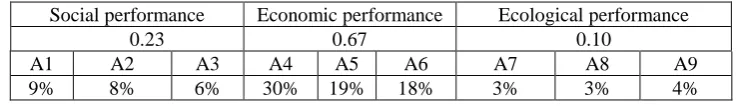
(13) Evaluation IndexTable 1. Indicators of the performance evaluation model.
Category layer Index layer Calculation
formula
The meaning of the indicator
Social performance
Satisfaction of Farmland Circulation(A1) ' 1 1 A A
The degree of farmers' satisfaction to the rural land transfer
Farmers' effective employment time index(A2)
' 2 2
2
A A
A
The change of farmers' effective employment time
Rural Engel Coefficient Realization Index(A3) ' 3 3 3 A A A
The changes in the standard of living of farmers
Economic performance
Per capita net income change index of farmers(A4)
' 4 4
4
A A
A
The change of farmers' quality of life
Labor input index in unit land(A5) ' 5 5 5 A A A
The change of farmers' labor input
The rate of output change in the unit land(A6)
' 6 6
6
A A
A
The change of land use rate
Ecological performance
Change rate of pesticide use per unit of land(A7)
' 7 7
7
A A
A
The impact of pesticide change on agricultural land
Change rate of fertilizer use per unit of land(A8)
' 8 8
8
A A
A
The influence of chemical fertilizer change on agricultural land
The change rate of the abandonment of land(A9)
' 9 9
9
A A
A
The influence on the circulation of farmland abandoned area
The data in this paper are mainly obtained by reviewing literature and studying on the pot. In order to ensure the reliability of the evaluation system, several samples from southern Shaanxi, northern Shaanxi and central Shaanxi were selected to calculate the weight of the comprehensive evaluation system. Based on the above model, the weights of the rural land transfer performance evaluation indexes are finally obtained, as shown in Table 2.
Table 2. Weights of the indexes.
Social performance Economic performance Ecological performance
0.23 0.67 0.10
A1 A2 A3 A4 A5 A6 A7 A8 A9 9% 8% 6% 30% 19% 18% 3% 3% 4%
Dynamic Monitoring and Analysis of Farmland Circulation Based on GIS
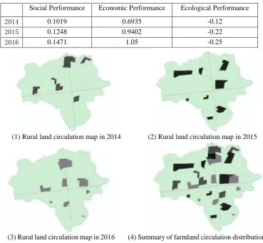
Spatial analysis is the core function of geographic information system. Through the geographical analysis of farmland circulation, the geographical distribution regularity and trend of farmland circulation are found out, and then the performance evaluation model of farmland circulation is provided to provide the basis for supervision and guidance of farmland circulation. This paper takes a township in southern Shaanxi as an example. Through the continuous observation and analysis of the agricultural land circulation in this area, find the temporal and spatial characteristics of regional agricultural land circulation, and provide the basis for the evaluation and supervision of farmland circulation. The distribution map of the farmland in the past three years and the annual distribution of agricultural land distribution are shown in Figure 1
[image:4.595.112.481.544.597.2]circulation not changed is "F". The basic data of each year's agricultural land transfer is obtained through the survey. Then use the MapInfo SQL query function to obtain the flow pattern of the flow and create a new layer, and through the superposition function to display the rural year of a year agricultural land distribution geographical distribution basic situation.
It can be seen from the figure that the rural land transfer is mainly concentrated in the northern region, the western region has a sporadic plot also carried out. The main features of the land transfer are relatively concentrated in scope and larger in scale.
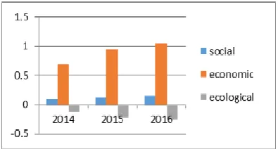
[image:5.595.116.486.232.573.2]After the data is gathered, through surveying on the pot, then process them with the model above, we can get the result of the social performance, economic performance and ecological performance from the year of 2014 to 2016 shown as the follow Table 3.
Table 3. The result of performance.
Social Performance Economic Performance Ecological Performance
2014 0.1019 0.6935 -0.12
2015 0.1248 0.9402 -0.22
2016 0.1471 1.05 -0.25
(1) Rural land circulation map in 2014 (2) Rural land circulation map in 2015
(3) Rural land circulation map in 2016 (4) Summary of farmland circulation distribution in each year
Figure 1. 2014~2016 rural land circulation distribution map.
Conclusion and Decision Analysis
Figure 2. 2014-2016 comprehensive performance of rural land transfer.
In combination with the above analysis. What the relevant departments should pay attention to the circulation of rural land is thatOn the basis of improving economic efficiency and society, strengthen ecological protection and management as much as possible, and improve the ecological environment.
References
[1] On rural land institutional change and innovation in China(II).
[2] Hua Yanling, Shi Guoqing and Liu Aiwen. Summary of theories and practices of land transfer
abroad [J]. World agriculture, 2006, 09:10-12.
[3] A. Th Ibraheem and D. A. Falih, “Applying Geographic Information System (GIS) for
Maintenance Strategy Selection,” Engineering Journal (ENG), Scientific Research Publication, Vol. 4, No. 1, 2012.
[4] Yang Xiaohui. A study on the mode of rural land circulation -- Journal of Yunnan Institute of