IN-SITU OBSERVATIONS USING TAGGED ANIMALS
Fabien Roquet (1), Lars Boehme (2), Marthan Bester (3), Horst Bornemann (4), Sophie Brasseur (5) , Jean-Benoit Charrassin (6), Daniel Costa (7) , Mike Fedak (2), Christophe Guinet (8) , Ailsa Hall (2), Robert Harcourt (9) ,
Mark Hindell (10), Kit M. Kovacs (11), Mary-Anne Lea (10), Phil Lovell (2), Andrew Lowther (11), Christian Lydersen (11), Clive McMahon (12) , Baptiste Picard (8), Gilles Reverdin (6) , Cécile Vincent (8)
(1) Department of Meterology (MISU), Stockholm University (Sweden), [email protected] (2) SMRU, University of St Andrews (UK), [email protected], [email protected],
[email protected], [email protected]
(3) University of Pretoria (South Africa), [email protected]
(4) Alfred-Wegener-Institut Helmholtz-Zentrum für Polar- und Meeresforschung (Germany),
(5) IMARES (Netherlands), [email protected]
(6) LOCEAN, Sorbonne University (France), [email protected], [email protected] (7) University of California, Santa Cruz (USA), [email protected]
(8) CEBC, Université de La Rochelle/CNRS (France), [email protected], [email protected],
(9) Macquarie University (Australia), [email protected]
(10) IMAS, University of Tasmania (Australia), [email protected], [email protected], (11) Norwegian Polar Institute (Norway), [email protected], [email protected],
(12) Sydney Institute of Marine Science, 19 Chowder Bay Road, Mosman, New South Wales, 2088, Australia,
ABSTRACT
Marine mammals help gather information on some of the harshest environments on the planet, through the use of miniaturized ocean sensors glued on their fur. Since 2004, hundreds of diving marine animals, mainly Antarctic and Arctic seals, have been fitted with a new generation of Argos tags developed by the Sea Mammal Research Unit of the University of St Andrews in Scotland, UK. These tags investigate the at-sea ecology of these animals while simultaneously collecting valuable oceanographic data. Some of the study species travel thousands of kilometres continuously diving to great depths (up to 2100 m). The resulting data are now freely available to the global scientific community at
http://www.meop.net. Despite great progress in their reliability and data accuracy, the current generation of loggers while approaching standard ARGO quality specifications have yet to match them. Yet, improvements are underway; they involve updating the technology, implementing a more systematic phase of calibration and taking benefit of the recently acquired knowledge on the dynamical response of sensors. Together these efforts are rapidly transforming animal tagging into one of the most important sources of oceanographic data in polar regions and in many coastal areas.
INTRODUCTION
The Polar oceans are changing rapidly. Ice caps in Antarctica and Greenland are melting, releasing large quantities of freshwater into surface waters. The winter sea ice cover is receding in the Arctic and in large areas of the Southern Ocean, promoting further warming. To understand the changing marine environment, it is necessary to have a comprehensive network of precise oceanographic measurements. Yet, until recently, the harsh climate and
[image:1.612.384.539.426.537.2]
remoteness of Polar marine areas in particular, but also large-scale offshore pelagic environments, made them extremely difficult to observe. Diving marine animals equipped with sensors are now increasingly filling in the gaps. In the last decade, tagged animals (Fig. 1) have
become an essential source of temperature and salinity profiles, especially for the polar oceans (Charrassin et al. 2008, Boehme et al. 2010, Fedak 2013, Roquet et al. 2013, Roquet et al. 2014). For example, elephant seals and Weddell seals have contributed 98 % of the existing temperature and salinity profiles within the Southern Ocean pack ice. The sensors are non-invasive (attached to the animal’s fur, they naturally fall off when the animal moults) and they document the animal’s behaviour in the context of its environment. More than 1000 animals have been equipped with oceanographic tags in the last decade, yielding several hundred thousand hydrographic profiles in the last decade (Fig. 2).
The international consortium MEOP (Marine mammals Exploring the Ocean Pole-to-pole) originally formed during the International Polar Year in 2008-2009, aims to coordinate animal tag
deployments, oceanographic data processing and data distribution at the global scale. The value of the hydrographic data produced by MEOP, within the existing Southern Ocean observing system, has recently been demonstrated (Roquet et al. 2013). Using seal-derived data to constrain model simulations of the ocean substantially modified the estimated surface mixed-layer properties and circulation patterns in the Southern Ocean. It improved the agreement of the model simulation with independent satellite observations of sea-ice concentration.
The oceanographic data collected in MEOP should improve significantly the quality of the projections provided by ocean-climate models (e.g. Mercator or Southern Ocean State Estimate). It is already bringing a wealth of new scientific findings, both in marine ecology (e.g. Hindell et al. 2016) and physical oceanography (e.g. Pellichero et al. 2016, Williams et al. 2016, Zhang et al. 2016).
CTD-SRDL LOGGERS
[image:2.612.307.536.115.264.2]The CTD Satellite Relay Data Loggers (CTD-SRDLs) are built at the Sea Mammal Research Unit (SMRU, University of St Andrews, UK). The miniaturized CTD unit is manufactured by Valeport Ltd (Devon, UK). The sensor head consists of a pressure transducer, a platinum resistance thermometer, and an inductive cell for measuring conductivity. The temperature and conductivity sensors have a precision (repeatability) of 0.005 °C and 0.005 mS/cm, respectively. Before being taken into the field, devices are calibrated in the laboratory by Valeport. CTD-SRDLs record hydrographic profiles during the ascent of seals (Boehme et al. 2009, Roquet et al. 2011) at a 0.5 Hz sampling frequency, retaining only the deepest dive in each six-hour time interval. Profiles are then telemetered in a compressed form (between 10 and 25 data points per profile, depending on the tag program) through the Advanced Research and Global Observation Satellite (ARGOS) system. For coastal applications, data are also sometimes telemetered using the GSM network (Cronin and McConnell, 2008). A detailed description of the protocols used by the tags to minimize size, energy and bandwith requirements can be found in
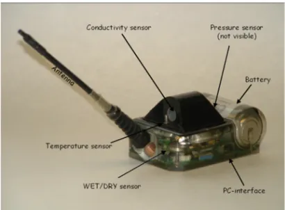
Figure 3: Photograph of a CTD-SRDL, with visible hardware components labelled (photograph by Lars Boehme, SMRU). The tag is housed in normal solid epoxy rated either to 500 m or 2000 m depth. Standard sensors include pressure, a wet/dry saltwater switch, temperature, conductivity. The tag has a PC interface, is powered by a primary cell (battery) and the standard version includes an antenna. From Photopoulou et al. (2015).
[image:2.612.338.543.481.632.2]
Photopoulou et al. (2015). Since 2012, most loggers have had an internal memory recording the logging profiles at sampling frequency. The whole data set can then be retrieved if the tag is recovered in the field. Recovering a tag has proved difficult in most cases, but there are some interesting exceptions. For example, almost 80% of tags deployed on the Kerguelen Islands have been later recovered. In this region, more than 50 loggers have been obtained providing datasets in critical areas of the Southern Ocean with unprecedented time and space resolution (C. Guinet, personal communication). The sites of Año Nuevo (California, USA) or Marion Island in the Southern Ocean are other places where recovery rates have usually been high.
First guess locations are determined based on the Doppler shifts observed from uplinks. End-of-dive locations are then estimated using a straightforward least-squares method, or a more elaborated Kalman filtering method. The latter method has been developed recently, and has been employed with most CTD-SRDLs records since 2012. A simple speed filter is then applied to exclude unrealistic locations, and a linear interpolation is finally applied between the locations that passed the filter at the time of each casts. The accuracy of ARGOS geo-positioning is typically about ±5 km (Lopez et al. 2015). A GPS Fastloc® head can also be added to improve the accuracy of geo-positioning, which can be particularly useful in coastal and shelf areas.
New sensor capabilities are also being added. One such sensor - the Cyclops 7 fluorometer is a compact cylinder
(110×25 mm after removal of the end cap), low energy consumption single channel fluorescence detector that can be
integrated to the CTD-SRDL tag (Guinet et al. 2013). It has been attached to elephant seal tags deployed in the Indian sector of the Southern Ocean since 2007, yielding a unique dataset of in-situ chlorophyll measurements in this extremely data poor, highly productive region (Blain et al. 2013). A new fluorescence sensor is currently under development with the plan to have it incorporated by default into the CTD-SRDL design with a very minor impact on the tag size.
An oxygen optode sensor has also been incorporated in a few CTD-SRDLs. The optode 4330 F is a compact cylinder (diameter: 36 mm—total length: 86 mm) designed to measure absolute oxygen concentration (Aanderaa Instruments and Precision Sensing GmbH, http://www.aanderaa.com). The measurement is based on the ability of dissolved oxygen to act as a dynamic fluorescence quencher, i.e. it decreases fluorescence intensity. Details on the oxygen data obtained with five CTD-Oxy-SRDLs deployed at Kerguelen Islands in October 2011 can be found in Bailleul et al. (2016). While this technology is still nascent, it has great potential for the future of integrated bio-physical and bio-geochemical research, as oxygen provides the most fundamental link between bio-physical and biogeochemical processes.
POST-PROCESSING AND DATA QUALITY
Temperature and salinity profiles are post-processed using a unified procedure of editing, adjustment, and validation (Roquet et al. 2011). Each individual CTD-SRDL dataset is post-processed separately, as each tag has different technical specifications and a different life history. A standard set of tests, adapted from Argo standard quality-control procedures, is first run to remove bad profiles, spikes, and outliers. Temperature and salinity adjustments are then determined, which vary from tag to tag, and they are applied identically to all profiles from a given tag. Owing to the relatively short life duration of CTD-SRDLs (typically 4 to 6 months), sensor drifts are assumed to be negligible, which is why the same adjustments are applied to all profiles from a given CTD-SRDL.
A salinity adjustment is first estimated for each tag in the form of a pressure dependent linear correction. This salinity bias is thought to be primarily induced by an external field effect on the conductivity sensor, which cannot
be corrected a priori because it depends on how the tag has been attached on the seal’s head, and must therefore be
corrected using delayed-mode techniques. The error model was suggested by numerous comparisons of CTD-SRDL profiles with ship-based CTD measurements carried out priori to the deployment. For CTD-SRDLs with profiles sampled in frozen areas, a temperature offset is also estimated using the local freezing temperature as a reference. Salinity adjustments parameters are estimated for each CTD-SRDL separately by comparisons of salinity measurements with existing historical and ARGO data. Because the southern ACC region (south of 55°S) is associated with a large-scale upwelling of circumpolar deep waters near the surface, the salinity at depth is very stable there, with a low natural variability highly suitable for use as a reference. Salinity data cross-comparisons between different CTD-SRDLs can also be used to estimate suitable adjustments for CTD-SRDLs when no profiles are available in the southern ACC region.
indicate that the thermal mass correction model of Lueck and Picklo (1990) can be successfully applied to CTD-SRDL salinity data, yielding significant improvements in sharp thermocline regions (Mensah and Roquet, in preparation). An improved knowledge of the dynamic response of temperature and conductivity sensors should allow the design of a better calibration model which will in turn lead to increased accuracy.
Once calibrated, the accuracy of post-processed CTD-SRDL measurements is estimated to be ±0.03 °C in temperature and ±0.05 psu (practical salinity unit) or better in salinity (Roquet et al. 2011). The final accuracy is highly dependent upon availability of ship-based CTD comparisons, and the type of water masses sampled during the deployment time. In best cases, an accuracy of ±0.01 °C and ±0.02 psu can be obtained.
INTEGRATION IN THE GLOBAL OBSERVING SYSTEM
An increasing number of studies now show the climatic importance of data-poor subpolar and polar oceanic regions. For example, more than 90% of extra heat in the Earth system is known to be stored in the oceans and the Southern Ocean in particular is a key site for understanding the uptake of heat and carbon. MEOP provides several thousand oceanographic profiles per year and these are helping us to close gaps in our understanding of the climate system. Instrumented animals efficiently complement other existing observing systems, such as Argo buoys, providing data in sea-ice covered areas and on high-latitude continental shelves. Miniaturized tags are also very successful in coastal areas, such as in Canadian, British, Danish or Dutch coastal areas. Such tags are also used on sea turtles in French Guiana, helping scientists to understand the foraging behaviour and ecological vulnerability of several species of turtles (Chambault et al. 2016).
A large proportion of these data is readily accessible from the MEOP-CTD database, available from the data portal meop.net into several standard file formats (netCDF Argo or ODV-style csv format). There, users (national data centers, researchers etc.) can freely and easily download the data with a guaranteed level of quality. This database is updated on an annual basis, and it has already been integrated into major oceanographic data centres including NODC, BODC, IMOS and Coriolis. Work is currently undertaken to further expand the database, implement the thermal cell correction, and distribute the fully resolved vertical profiles available from recovered tags in the next database update.
To achieve global integration, the EuroGOOS Animal-Borne Instrument (ABI) Task Team has recently been launched (chair: L. Boehme, http://eurogoos.eu/animal-borne-instruments/). Two main goals of the ABI task team
are 1) to assist in the standardization of animal-borne instrument operations, data and applications of a multi-purpose
network, including all applications of animal-borne instruments (physical and biological oceanography, animal behaviour, and management); and 2) to promote the integration of animal-borne instruments in ongoing and future European initiatives and identify relevant products required by end-users, foster interdisciplinary work, and support relevant proposals. A specific emphasis will initially be put toward coastal data integration. Indeed an enormous amount of temperature data has been sampled in European seas from tagged grey seals and harbour seals and there is a need to gather and quality control these data before they can be included in global ocean databases. Large efforts are also ongoing to provide a unified real-time data flow for operational applications.
Overall, the past decade of animal tagging has demonstrated the feasibility and value of this approach for ocean observation. At the core of this success has been a unique collaboration between biologists and physical oceanographers fostered by the MEOP consortium, which provides one of the few examples of a truly multi-disciplinary approach that has created great outputs for both communities. A new critical phase of development has now commenced, requiring further improvements in technology (smaller, cheaper, better units) and better coordination of national efforts at a global level. The prospective outcomes of these cross-disciplinary international efforts are particularly promising for advancing polar and coastal oceanography research.
ACKNOWLEDGEMENTS
REFERENCES
Bailleul, F., Vacquie-Garcia, J., and Guinet, C., 2015. Dissolved Oxygen Sensor in Animal-Borne Instruments: An Innovation for Monitoring the Health of Oceans and Investigating the Functioning of Marine Ecosystems. PLoS ONE, 10:e0132681. Doi: 10.1371/journal.pone.0132681
Blain, S., Renaut, S., Xing, X., Claustre, H., and Guinet, C., 2013. Instrumented elephant seals reveal the seasonality in chlorophyll and light-mixing regime in the iron-fertilized Southern Ocean. Geophysical Research Letters, 40:2013GL058065.
Boehme, L., Lovell, P., Biuw, M., Roquet, F., Nicholson, J., Thorpe, S., Meredith, M.P., Fedak, M., 2009. Technical Note: Animal-borne CTD-Satellite Relay Data Loggers for real-time oceanographic data collection. Ocean Science, 5:685-695. Boehme, L., Kovacs, K., Lydersen, C., Nøst, O.A., Biuw, M., Charrassin, J.-B., Roquet, F., Guinet, C., Meredith, M., Nicholls,
K., Thorpe, S., Costa, D.P., Block, B., Hammill, M., Stenson, G., Muelbert, M., Bester, M.N., Plötz, J., Bornemann, H., Hindell, M., Rintoul, S., Lovell, P., Fedak, M.A., 2010 Biologging in the global ocean observing system. In: Hall, J.; Harrison, D.E.; Stammer, D., (eds.) Proceedings of Ocean Obs 09: Sustained ocean observations and information for society. Venice, Italy, European Space Agency, 9pp. (ESA Publication, WPP-306, Vol. 2).
Chambault, P., de Thoisy, B., Heerah, K., Conchon, A., Barrioz, S., Dos Reis, V., Berzins, R., Kelle, L., Picard, B., Roquet, F., Le Maho, Y., and Chevallier, D., 2016. The influence of oceanographic features on the foraging behavior of the olive ridley sea turtle Lepidochelys olivacea along the Guiana coast. Progress in Oceanography, 142:58-71.
Charrassin, J.-B., Hindell, M., Rintoul, S. R., Roquet, F., Sokolov, S., Biuw, M., Costa, D., Boehme, L., Lovell, P., Coleman, R., Timmermann, R., Meijers, A., Meredith, M., Park, Y.-H., Bailleul, F., Goebel, M., Tremblay, Y., Bost, C.-A., McMahon, C. R., Field, I. C., Fedak, M. A., and Guinet, C., 2008. Southern Ocean frontal structure and sea-ice formation rates revealed by elephant seals. Proceedings of the National Academy of Sciences, 105:11634-11639.
Cronin, M. A. and McConnell, B. J., 2008. SMS seal: A new technique to measure haul-out behaviour in marine vertebrates. Journal of Experimental Marine Biology and Ecology, 362:43-48.
Fedak, M. A., 2013. The impact of animal platforms on polar ocean observation. Deep Sea Research Part II: Topical Studies in Oceanography, 88-89:7-13.
Guinet, C., Xing, X., Walker, E., Monestiez, P., Marchand, S., Picard, B., Jaud, T., Authier, M., Cotte, C., Dragon, A. C., Diamond, E., Antoine, D., Lovell, P., Blain, S., D'Ortenzio, F., and Claustre, H., 2013. Calibration procedures and first dataset of Southern Ocean chlorophyll a profiles collected by elephant seals equipped with a newly developed CTD-fluorescence tags. Earth System Science Data, 5:15-29.
Hindell, M. A., McMahon, C. R., Bester, M. N., Boehme, L., Costa, D., Fedak, M. A., Guinet, C., Herraiz-Borreguero, L., Harcourt, R. G., Huckstadt, L., Kovacs, K. M., Lydersen, C., McIntyre, T., Muelbert, M., Patterson, T., Roquet, F., Williams, G., and Charrassin, J.-B., 2016. Circumpolar habitat use in the southern elephant seal: implications for foraging success and population trajectories. Ecosphere, 7. doi: 10.1002/ecs2.1213
Lopez, R., Malardé, J.-P., Danès, P., and Gaspar, P., 2015. Improving Argos Doppler location using multiple-model smoothing. , 3:1-9.
Lueck, R. G. and Picklo, J. J., 1990. Thermal Inertia of Conductivity Cells: Observations with a Sea-Bird Cell. Journal of Atmospheric and Oceanic Technology, 7:756-768.
Pellichero, V., Sallée, J.-B., Schmidtko, S., Roquet, F., and Charrassin, J.-B., 2016. The ocean mixed-layer under Southern Ocean sea-ice: Seasonal cycle and forcing. Journal of Geophysical Research: Oceans. Doi: 10.1002/2016JC011970
Photopoulou, T., Fedak, M. A., Matthiopoulos, J., McConnell, B., and Lovell, P., 2015. The generalized data management and collection protocol for Conductivity-Temperature-Depth Satellite Relay Data Loggers. Animal Biotelemetry, 3:21. Roquet, F., Charrassin, J.-B., Marchand, S., Boehme, L., Fedak, M., Reverdin, G., and Guinet, C., 2011. Delayed-Mode
Calibration of Hydrographic Data Obtained from Animal-Borne Satellite Relay Data Loggers. Journal of Atmospheric and Oceanic Technology, 28:787-801.
Roquet F. et al., 2013. Estimates of the Southern Ocean General Circulation Improved by Animal-Borne Instruments. Geoph. Res. Letts., 40:1-5. doi: 10.1002/2013GL058304
Roquet F. et al., 2014. A Southern Indian Ocean database of hydrographic profiles obtained with instrumented elephant seals. Nature Scientific Data, 1:140028, doi: 10.1038/sdata.2014.28
Williams, G. D., Herraiz-Borreguero, L., Roquet, F., Tamura, T., Ohshima, K. I., Fukamachi, Y., Fraser, A. D., Gao, L., Chen, H., McMahon, C. R., Harcourt, R., and Hindell, M., 2016. The suppression of Antarctic bottom water formation by melting ice shelves in Prydz Bay. Nature Communications, doi: 10.1038/ncomms12577