A STUDY ON THE EFFECTS OF 10 KT YIELD NUCLEAR BLAST IN A HYPOTHETICAL
1
Vijayaraghavan
1
Balaji Institute of Engineering and Technology, Thandalam, Chennai, India
2Institute of Remote Sensing, College of Engineering, Anna University, Chennai, India.
3Radiological Safety Division, Indira Gandhi Centre for Atomic Research, Kalpakkam, India.
ARTICLE INFO ABSTRACT
A Nuclear bomb explosion within or immediately nearby a City or town can cause catastrophic damage on the building's, infrastructures, basic amenities, and shutting down of cr
systems. Nuclear explosions produce immediate effects such as Blast, thermal radiation, prompt ionizing radiations and delayed destructive effects such as radioactive fallout and other possible environmental effects, cause damage over an
present study a Simulated City with all basic amenities with an area of 125 Square Kilometers is developed using Satellite Data of different Cities and GIS. Data for existing City is not used in this study because of security reasons. Any how the City is planned and modeled as per second Master plan of Chennai Metropolitan Area. The Model City is detonated with a yield of 10 Kiloton of Nuclear explosions using openly available source Hotspot 2.07 as the
locations. The ill effects are predicted and modeled using Arc GIS.
INTRODUCTION
A disaster is a crisis situation that is triggered by either natural calamity or human induced accidents which out
societal capability to cope with. The features of disaster are Unpredictability, Unfamiliarity, Speed, Urgency, Uncertainty, and Threat. The Detonation of a Single Nuclear Bomb or single nuclear device exploded in any city either by accident, terrorism, or any other reason, it is likely to wipe out hundreds of thousands of people which may cause a Local Disaster on a Scale. That would cause the end of civilization in the countries concerned, and perhaps over the whole world, as well as radioactive contamination of whole continents, and terrible damage to the environment and ecology. Approximately 85 percent of the energy of a nuclear weapon produces Blast energy and Thermal energy (50% Blast energy + 35% Thermal energy). The remaining 15 percent of the energy is released as various type of nuclear radiation. Of this, 5 percent constitutes the initial nuclear radiation, defined as that produced within a minute or so of the explosion, are mostly gamma rays and neutrons. The final 10 percent of the total fission energy represents that of the residual (or delayed) nuclear radiation, which is emitted over a period of time. This is largely due to the radioactivity of the fission products present in the weapon residues, or debris, and fallout after the explosion. If a city of one million or two million would be struck by a single one megaton bomb around one third of inhabitants would be killed instantly or fatally injured, one third seriously injured and the rest uninjured or slightly injured The two bombs that have been exploded over cities,
ISSN: 0975-833X
Article History:
Received 8th August, 2011
Received in revised form
19th September, 2011
Accepted 8th October, 2011
Published online 20th November, 2011
Key words:
Building's, infrastructures, Basic amenities,
Shutting down of critical life.
*Corresponding author: [email protected]
RESEARCH ARTICLE
A STUDY ON THE EFFECTS OF 10 KT YIELD NUCLEAR BLAST IN A HYPOTHETICAL
CITY USING GIS
Vijayaraghavan, C.,
2Thirumalaivasan, D. and Venkatesan
Institute of Engineering and Technology, Thandalam, Chennai, India
Institute of Remote Sensing, College of Engineering, Anna University, Chennai, India.
Division, Indira Gandhi Centre for Atomic Research, Kalpakkam, India.
ABSTRACT
A Nuclear bomb explosion within or immediately nearby a City or town can cause catastrophic damage on the building's, infrastructures, basic amenities, and shutting down of cr
systems. Nuclear explosions produce immediate effects such as Blast, thermal radiation, prompt ionizing radiations and delayed destructive effects such as radioactive fallout and other possible environmental effects, cause damage over an extended period ranging from hours to years. In this present study a Simulated City with all basic amenities with an area of 125 Square Kilometers is developed using Satellite Data of different Cities and GIS. Data for existing City is not used in this udy because of security reasons. Any how the City is planned and modeled as per second Master plan of Chennai Metropolitan Area. The Model City is detonated with a yield of 10 Kiloton of Nuclear explosions using openly available source Hotspot 2.07 as the
locations. The ill effects are predicted and modeled using Arc GIS.
Copy Right, IJCR, 2011, Academic Journals
A disaster is a crisis situation that is triggered by either natural calamity or human induced accidents which out-strips the societal capability to cope with. The features of disaster are ty, Unfamiliarity, Speed, Urgency, Uncertainty, The Detonation of a Single Nuclear Bomb or a single nuclear device exploded in any city either by accident, terrorism, or any other reason, it is likely to wipe out which may cause a Local That would cause the end of civilization in the countries concerned, and perhaps over the whole world, as well as radioactive contamination of whole continents, and ment and ecology. Approximately 85 percent of the energy of a nuclear weapon produces Blast energy and Thermal energy (50% Blast energy + 35% Thermal energy). The remaining 15 percent of the energy is released as various type of nuclear radiation. Of this, 5 percent constitutes the initial nuclear radiation, defined as that produced within a minute or so of the explosion, are mostly gamma rays and neutrons. The final 10 percent of the total fission energy represents that of the residual (or delayed) radiation, which is emitted over a period of time. This is largely due to the radioactivity of the fission products present in the weapon residues, or debris, and fallout after the If a city of one million or two million would be ngle one megaton bomb around one third of inhabitants would be killed instantly or fatally injured, one third seriously injured and the rest uninjured or slightly injured The two bombs that have been exploded over cities,
Hiroshima and Nagasaki in Japan in August 1945, were in the 10- to 20-kiloton range.. The magnitude of a nuclear explosion is quantified in terms of the amount of conventional explosive it would take to create the same blast effect. The amount of explosive power from a nuclear explosion, or the “yield,” is measured relative to TNT, and is u
tons (kilotons, or KT) of TNT. A small nuclear device, for example, would be a 1 KT device, meaning it would produce an explosive yield equivalent to one thousand tons of TNT. Most nuclear weapons in the world today were designed deliver less than 200 KT; but, some can deliver millions of tons (MT) of yield.
EFFECTS OF 10 KT NUCLEAR EXPLOSION MODERN CITY
Blast and Thermal Effects of 10 KT yield Nuclear Explosion
A surface burst of a nominal 10
populated modern city would be even more devastating. Because of the heavy local fallout of radioactive material associated with a ground burst, a ground level detonation would greatly increase the number of deaths and injuries from radiation. In addition, there would be a fallout spot, or plume, delayed by, perhaps, 30 minutes, at a distance of 5 to 20 kilometers (km) from the ground burst. Another new phenomenon would be a crater, which, on dry soil or dry soft rock, would have a diameter of about 75
about 17 m (Glasstone and Dolan, 1977). A blast of invisible nuclear radiation would be released within microseconds, International Journal of Current Research
Vol. 3, Issue, 11, pp.057-063, November, 2011
INTERNATIONAL
A STUDY ON THE EFFECTS OF 10 KT YIELD NUCLEAR BLAST IN A HYPOTHETICAL
Venkatesan, R
3Institute of Engineering and Technology, Thandalam, Chennai, India
Institute of Remote Sensing, College of Engineering, Anna University, Chennai, India.
Division, Indira Gandhi Centre for Atomic Research, Kalpakkam, India.
A Nuclear bomb explosion within or immediately nearby a City or town can cause catastrophic damage on the building's, infrastructures, basic amenities, and shutting down of critical life-safety systems. Nuclear explosions produce immediate effects such as Blast, thermal radiation, prompt ionizing radiations and delayed destructive effects such as radioactive fallout and other possible extended period ranging from hours to years. In this present study a Simulated City with all basic amenities with an area of 125 Square Kilometers is developed using Satellite Data of different Cities and GIS. Data for existing City is not used in this udy because of security reasons. Any how the City is planned and modeled as per second Master plan of Chennai Metropolitan Area. The Model City is detonated with a yield of 10 Kiloton of Nuclear explosions using openly available source Hotspot 2.07 as the surface blast at various locations. The ill effects are predicted and modeled using Arc GIS.
Copy Right, IJCR, 2011, Academic Journals. All rights reserved.
Hiroshima and Nagasaki in Japan in August 1945, were in the The magnitude of a nuclear explosion is quantified in terms of the amount of conventional explosive it would take to create the same blast effect. The amount of explosive power from a nuclear explosion, or the “yield,” is measured relative to TNT, and is usually in the thousands of tons (kilotons, or KT) of TNT. A small nuclear device, for example, would be a 1 KT device, meaning it would produce an explosive yield equivalent to one thousand tons of TNT. Most nuclear weapons in the world today were designed to deliver less than 200 KT; but, some can deliver millions of
EFFECTS OF 10 KT NUCLEAR EXPLOSIONS IN A
Blast and Thermal Effects of 10 KT yield Nuclear Explosion
A surface burst of a nominal 10-kiloton explosive in a densely populated modern city would be even more devastating. Because of the heavy local fallout of radioactive material associated with a ground burst, a ground level detonation would greatly increase the number of deaths and injuries from tion, there would be a fallout spot, or plume, delayed by, perhaps, 30 minutes, at a distance of 5 to 20 kilometers (km) from the ground burst. Another new phenomenon would be a crater, which, on dry soil or dry soft rock, would have a diameter of about 75 m and a depth of about 17 m (Glasstone and Dolan, 1977). A blast of invisible nuclear radiation would be released within microseconds,
Fig. 1: Energy from a Nuclear Weapon
Fig. 2: Blast Effect- Buffer Zones of peak overpressure and distance for a 10 KT explosion (Not to Scale)
Fig. 3: Representative damage zones for 10 KT nuclear explosion (not to scale)
(Courtesy Homeland Security Council & Office of Science and
Technology Policy, USA)
followed within milliseconds by thermal radiation from the surface of the expanding fireball. Winds and destructive overpressure would follow, knocking down buildings in the destroyed area, breaking windows out to a radius of 5.3 km (at 0.5 psi, overpressure from a surface burst of 10 kiloton yield), and converting people and objects into lethal missiles (Glasstone and Dolan, 1977). The damages due to the blast and Thermal energy may be classified into three Zones as Light Damage Zone, Moderate Damage Zone and severe Damage Zone (Figure 3). There are no clear boundaries between damage zones resulting from a nuclear detonation, but generally, the light damage (LD) zone is characterized by broken windows and easily managed injuries; the moderate
(MD) zone by significant building damage, rubble, downed utility poles, overturned automobiles, fires, and serious injuries; and the no-go (NG) zone by completely destroyed infrastructure and radiation levels resulting in unlikely survival of victims.
Radiation Effects due to 10 KT yield Nuclear Explosion
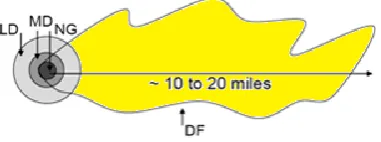
[image:2.595.333.524.369.440.2]About six seconds later, the nearest potential survivors would feel an enormous blast and wind. The intensely bright fireball would be long gone by then and some fires would be burning, but more would later be ignited by broken gas mains and the ignition of combustible materials from buildings. The crater material would give off intense, but unfelt, radiation in the immediate area; a total dose of 4 Sieverts (4 Sv or 400 rem) would be lethal to at least 50 percent of the people exposed. The bomb debris, mixed with hundreds of thousands of tons of material from the crater, would rise in the prototypical mushroom cloud into the stratosphere from which coarse debris particles, along with much of the radioactive material, would fall out over a period of 30 minutes or so. With a nominal wind speed, there would be a fallout plume about 2 kilometers (km) wide to a downwind distance of about 20 km. The area affected by lethal fallout might be on the order of 20 km2. An example of such a plume with boundaries at the dose rate of 10 rem/hr is shown in Figure 2.
Fig. 4: Nominal fallout plume bounded by 10 rem/hr initial dose rate. DF = Dangerous fallout zone; LD = Light Damage; MD =
Moderate Damage; and NG = “No Go.” (Source: Homeland Security Council, 2009 (Not to scale))
Role of GIS in analyzing the affected zones
[image:2.595.39.287.423.569.2]Fig.: 5 Raster Data of Hypothetical City (ARC GIS Edited Google Pro Imagery)
Fig. 6: Vector Data of Hypothetical City (Digitized using ARC GIS)
Fig. 8: Map showing the affected Zones and Fall Out patterns for the blast near SEZ
Fig. 9: Map showing the affected Zones and Fall Out patterns for the blast near Residential Area
be retrieved for specific purposes in decision making during disasters.
Need for present study
One of the most catastrophic incidents that could befall the India, causing enormous loss of life and property and severely damaging economic viability, is a nuclear detonation in an Indian city. It is incumbent upon all levels of government, as well as public and private parties within the country, to prepare for this incident through focused nuclear attack response planning. Nuclear explosions present substantial and immediate radiological threats to life and a severely damaged response infrastructure. Local and State community preparedness to respond to a nuclear detonation could result in life-saving on the order of tens of thousands of lives. The purpose of this study is to provide emergency planners with nuclear detonation-specific response recommendations to maximize the preservation of life in the event of an urban nuclear detonation. This paper addresses the unique effects and impacts of a nuclear detonation such as scale of destruction, blast effects and radiation dose plume path. The guidance is aimed at response activities in an environment with a severely compromised infrastructure for the first few days (i.e., 24–72 hours) when it is likely that many organizational resources will still be en route to the incident.
Study area
[image:3.595.36.290.56.360.2] [image:3.595.48.279.412.748.2]Industrial buildings, Institutional buildings, Recreational buildings, etc. The Residential buildings are assumed to be RCC structures with single storey to multi storied buildings. The roads are planned with a widening of 10 m to 30 m. Google Pro was used to collect the raster images of existing
cities all over the world and the features such as buildings and other infrastructures were edited and merged using the GIS software ARC GIS( Fig. 5). Around 125 square kilometers of
[image:4.595.75.523.79.160.2]the raster data was also digitized using the GIS software (Fig 6).
Table 1: Relation of wind speeds to peak overpressure and distance for a 10 KT explosion (Glasstone and Dolan 1977)
Overpressure (psi)
Over pressure
KN/m2
Approximate Distance from Ground Zero (miles) [km]
Maximum Wind Speed (mph) [km/h]
50 344.825 0.18 [0.29] 934 [1503]
30 206.875 0.24 [0.39] 669 [1077]
20 137.93 0.30 [0.48] 502 [808]
10 68.965 0.44 [0.71] 294 [473]
5 34.482 0.6 [0.97] 163 [262]
[image:4.595.89.508.183.291.2]2 13.793 1.1 [1.8] 70 [113]
Table 2: Area Details and % of land used for Amenities & infrastructures in Hypothetical City
Details of Infra structures Chennai City Study Area
Extent in Sq.Km. % Extent in Sq.Km. %
Residential 95.23 54.25 55.10 43.93
Commercial 12.45 7.09 8.00 6.39
Industrial 9.08 5.17 7.00 5.59
Institutional 32.43 18.48 22.8 17.57
Open Space & Recreation 3.66 2.09 3.85 3.08
Agricultural 0.99 0.57 1.2 0.96
Non Urban 0.82 0.47 0.7 0.56
Others (Vacant, Forest, Hills, Low lying, Water bodies etc.,)
[image:4.595.131.461.320.418.2]20.87 11.89 26.54 21.20
Table: 3. Damage Zones with Peak over Pressure and Radius (source- HOT SPOT)
Damage Zones Blast Overpressure
(psi)
Distance from Ground Zero [km]
Severe Damage (SD) or No-Go Zone 75 0.27
50 0.32
30 0.40
20 0.48
15 0.54
Moderate Damage (MD) Zone: 08 0.74
05 0.96
Light Damage (LD) Zone 0.5 4.09
Table 4. Damages to the structures and injuries to human bodies due to peak over pressure of 10 KT yield Nuclear Detonation (Glasstone and Dolan 1977)
Peak Overpressure (psi) Type of Structure Degree of Damage
0.15 – 0.22 Typical window glass breakage Moderate
0.5 – 1.1 Minor damage to some buildings Moderate
1.1 – 1.8 Panels of sheet metal buckled Moderate (broken)
1.8 – 2.9 Failure of concrete block walls Severe
Over 5.0 Collapse of wood framed buildings Severe
4 – 7 Serious damage to steel framed buildings Severe
6 – 9 Severe damage to reinforced concrete structures Moderate
10 – 12 Probable total destruction of most buildings Severe (collapse)
Peak Overpressure (psi) Type of Injury to People in the Open
5 Threshold for eardrum rupture
15 Threshold for serious lung damage
50 50% incidence of fatal lung damage
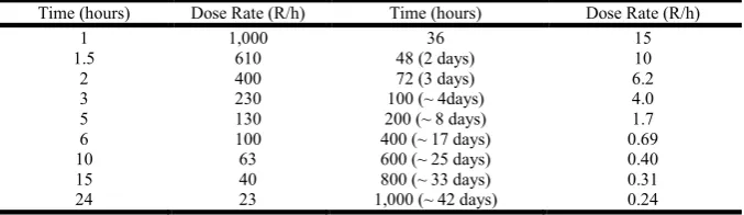
Table 5: Example dose rate decay from early fallout tracked as a function of time after a nuclear explosion; adapted from Glasstone and Dolan
Time (hours) Dose Rate (R/h) Time (hours) Dose Rate (R/h)
1 1,000 36 15
1.5 610 48 (2 days) 10
2 400 72 (3 days) 6.2
3 230 100 (~ 4days) 4.0
5 130 200 (~ 8 days) 1.7
6 100 400 (~ 17 days) 0.69
10 63 600 (~ 25 days) 0.40
15 40 800 (~ 33 days) 0.31
[image:4.595.135.461.455.581.2] [image:4.595.128.467.610.708.2]Related works
Alan F. Phillips from his study indicates that the Detonation of
a Single Nuclear Bomb or “Warhead” Would Cause a Local Disaster on a Scale That Few People in the World have seen and survived. The nuclear bombs available to the great military powers of the world range in power from several megatons down to a few kilotons. A “megaton” is the explosive power of one million tons of TNT. A “kiloton” is the power of one thousand tons of TNT. Bombs likely to be available to terrorist organizations or governments other than the great military powers would be in the 10- to 100-kiloton range. Steinmeyer. K.P, has studied that an atomic bomb explosion results in a great amount of damage due to blast and fire, followed by the highly radioactive fallout. At Chernobyl there was no nuclear detonation so the initial local damage was limited to the Unit 3 Reactor Building and adjacent structures. However, the amount of radioactive material released during the accident was far more than would have resulted from a nuclear explosion. Abdul Mannan, in his study expressed thatalthough an act of nuclear terrorism is of very remote probability in Pakistan, nevertheless, an attempt has been made to review the pre and post 9/11 threat of nuclear terrorism and its impact on Pakistan. Vamanu. D et al, in their paper indicates that it was confirmed in a consensual manner by the various authorities and technical expert parties present and participating in the exercise that RODOS is indeed a viable and functional decision support system, worth implementation in the National Emergency Center, and a commitment was publicly expressed to this effect. It became
apparent that the application of RODOS is a demanding endeavor in several respects, including, inter alia, the need of having the system implemented and fully operational in the Situation Room, wherever it may be, to avoid forbidding telecommunication stopgaps that may get aggravated in a real crisis.
Jan Beyea1 and Maureen Hatch, have studied that Geographic
[image:5.595.42.560.87.226.2]modeling of individual exposures using air pollution modeling techniques can help in both the design of environmental epidemiologic studies and in the assignment of measures that delineate regions that receive the highest exposure in space and time. Hemant B. Kaushik and Sudhir K. Jain investigate the possibilities to improve the Dutch nuclear emergency management system, a pilot study was carried out on a data assimilation method for our atmospheric dispersion model. By means of the data assimilation method, the prediction of potentially contaminated areas in the early and late phases of a nuclear accident can significantly be improved. Zakharovet al, in their paper expressed that; Accident at the Chernobyl nuclear power plant (NPP) in April 1986appeared to be one of most serious ecological catastrophes. It led to the nuclear pollution of vast surrounding territories and had severe global ecological consequences. El-Harbawi et alhave studied about the air pollution problem which received more attention during the last decades whereby there has been a significant increase in public awareness of the potential dangers caused by chemical pollutants and their effects on both human beings and the environment. DeeleshMandloi and Rajiv Gupta, in their paper presents a method by which the accident-prone
Table 7: Damage Assessment for 10 KT Nuclear Explosion near Special Buildings Zone
Nuclear Yield = 10 KT Wind Speed = 5.0 m/sec Wind Direction= 90° (East to West)
Damage Details
(Including Buildings & Human lives)
Damages due to Blast Effects Affected Zones Vs Peak over Pressure (Psi)
Total Damages I
75
II 50
III 30
IV 20
V 15
VI 8
VII 5
VIII 0.5
Distance from Ground zero 0.27 0.32 0.40 0.48 0.54 0.74 0.96 4.09 -
Area Affected (Km2) 0.057 0.023 0.046 0.055 0.048 0.201 0.294 12.42 13.144
Residential Buildings 11 13 15 15 13 23 20 2190 2300
Commercial Buildings 2 4 4 5 4 5 3 202 229
Industrial Buildings - - - 1 49 50
Institutional Buildings 1 1 2 3 4 7 7 161 186
Open space & Recreation 3 3 4 4 4 5 8 55 86
Others - - - 2 38 40
Population Affected (Approximate)
4883 2863 5108 5921 3965 22781 21007 939113 1005641
Causalities Details: Human Loss (Zone I, II, III & IV) = 18775. Severe Injuries (Zone V, VI & VII) = 47753. Light Injuries (Zone VIII) = 939113
.
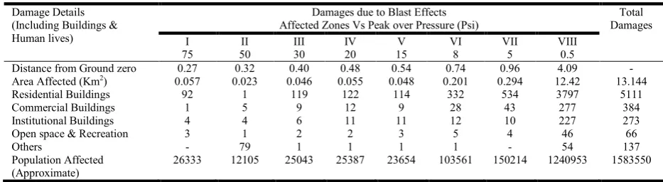
Table 8: Damage Assessment for 10 KT Nuclear Explosion near Residential Zone
Nuclear Yield = 10 KT Wind Speed = 5.0 m/sec Wind Direction= 0° (North to South)
Damage Details (Including Buildings & Human lives)
Damages due to Blast Effects Affected Zones Vs Peak over Pressure (Psi)
Total Damages I
75
II 50
III 30
IV 20
V 15
VI 8
VII 5
VIII 0.5
Distance from Ground zero 0.27 0.32 0.40 0.48 0.54 0.74 0.96 4.09 -
Area Affected (Km2) 0.057 0.023 0.046 0.055 0.048 0.201 0.294 12.42 13.144
Residential Buildings 92 1 119 122 114 332 534 3797 5111
Commercial Buildings 1 5 9 12 9 28 43 277 384
Institutional Buildings 4 4 6 11 11 12 10 227 273
Open space & Recreation 3 1 2 2 3 5 4 46 66
Others - 79 1 1 1 1 - 54 137
Population Affected (Approximate)
26333 12105 25043 25387 23654 103561 150214 1240953 1583550
[image:5.595.62.529.281.409.2]locations on roads, commonly termed as accident black spots, can be identified. The methodology incorporates a model which implements prioritization of roads for accident occurrence, followed by analysis using a Geographic Information System (GIS).
Thomas J. Cova and Richard L. Church, have studied in their
paper that a classification of this nature offers a unique approach to assessing community vulnerability in regions subject to fast-moving hazards of uncertain spatial impact. The approach is founded on an integer programming (IP) model called the critical cluster model (CCM). A heuristic algorithm is described which is capable of producing efficient, high-quality solutions to this model in a GIS context. Lu Li-zhen et al, in their paper through analysis of remote sensing technology’s application in the investigation and appraisal of geological hazard, in view of the application of remote sensing interpretation about debris flow geological hazard in small basin area, presented the remote sensing interpretation method (RSVH) based on virtual GIS and hydrology spatial analysis.
METHODOLOGY
Design of Hypothetical City
Due to the security reasons a simulated city is used in this present study instead of using Chennai City. Total area of the Model City is around 125 square kilometers. Roughly around 2.5 million (25 lakhs) is assumed to be the population of the hypothetical city. The infrastructures and the basic amenities are planned according to the second master plan of development for Chennai Metropolitan Area. Table given below is the details of the simulated city.
Analysis of Effects due to detonation 10 KT yields Nuclear Explosion using GIS
Blast Effects
The entire Hypothetical City of 125 square kilometers was divided into following three Zones (scenarios) to study the effects of Nuclear Explosion. The yield for the nuclear explosion is 10 KT and the speed of the wind is 5 meter per second (m/sec). The explosion was made as surface blast in day time. The peak over pressure for this blast was calculated from the HOT SPOT model. The following were the three scenarios developed to model the blast effects and radioactive fallouts (plume path)
Scenario 1: Special Buildings Zone (IT offices, Commercial buildings, Administrative offices)
Scenario 2: Residential Zone (Residential, Mixed Residential, Recreational, etc.)
The detonation of 10 KT Nuclear blast has produced both immediate and delayed destructive effects such as Blast, thermal radiation, and prompt ionizing radiation causing significant destruction within seconds or minutes of a nuclear detonation. Each of these effects is calculated from the point of detonation. The power of over pressure indicated in terms of psi (Pounds per square inch) will reduce with the increase in distance. The relationship between over pressure, distance and wind speeds (Table-3) and the effects of the over pressure
on the buildings and infrastructures (Table -4) are listed in the following tables.
Radiation Effects
Radiation casualties may be caused by prompt nuclear radiation or by radioactive fallout. Prompt ionizing radiation consists of x rays, gamma rays, and neutrons produced in the first minute following the nuclear explosion. Unprotected individuals could receive in excess of the prompt ionizing radiation dose required for 50% lethality (within weeks), out to a distance of 1.4 km (0.88 miles) The delayed ionizing radiation is produced by fission products and neutron-induced radionuclide’s in surrounding materials (soil, air, structures, nuclear device debris). These radioactive products will be dispersed downwind with the fireball/debris cloud. As the cloud travels downwind, the radioactive material that has fallen and settled on the ground creates a footprint of deposited material (fallout). The exposure to the fallout is the dominant source of radiation exposure for locations beyond the prompt effects of the nuclear detonation. The dose received depends upon the time an individual remains in the contaminated area. Unprotected individuals remaining in the contamination zone for the first hour following the nuclear explosion could receive in excess of the fallout dose required for 50% lethality (within weeks), out to a distance of about 7 km (5 miles). The idealized maximum width of the fallout footprint (actual width could be larger or smaller) is about 0.32 km (0.20 miles). The downwind extent of the 50% lethality contour increases to approximately 15 km (10 miles) and the 50% lethality contour width increases to about to about 0.81 km (0.50 miles). Fallout record tracked after a nuclear explosion was shown in the table (Table 5).
RESULTS AND DISCUSSION
Model of 10 KT Nuclear Explosion near Special Buildings Zone of Hypothetical City
In this scenario, a 10 Kilo ton nuclear explosion was detonated near the special buildings and IT corridor zone. The motivation is to collapse the economy of the City or country. The blast effects fall out patterns and radiation dispersion of the affected area were shown in the map given below (Figure- 8). The details of yield, Wind speed and direction and the damage assessment (both structural and human) of the affected area were also given in the Table 7.
Model of 10 KT Nuclear Explosion in the Residential Area of Hypothetical City
In this scenario a 10 Kiloton nuclear blast was detonated near the Residential zone. The motivation is to create more damage to the human and assets in the City or country. The blast effects fall out patterns and radiation dispersion of the affected area were shown in the map given below (Figure 9). The details of yield, Wind effect and Direction and the damage assessment (both structural and human) of the affected area were also given in the Table 8.
Conclusions
might expose people in a 20 square kilometers area to radiation levels that would cause 50 percent mortality. From the above study it is observed that
In the detonation which took place near the air port, around 10,000 people will be killed directly and 30,000 will be injured apart from structural damages and damages on other assets.
In the second case of explosion near the special economy zone around 12000 people killed and 32,000 injured apart from other collateral injuries.
In the third case of explosion near the residential area nearly 21,000 people killed and 140,000 people may be lightly and severely injured apart from several buildings collapse.
In the fourth case of explosion near coastal zone around 15000 people killed and 25000 people may got injure apart from structural damages.
Although not everyone in such an attack can be saved, it is the government’s responsibility to do the analysis, planning, simulation, and communication that might be needed for an attack on any one of 20 or more target cities. It would fall to local governments to prepare regulations that would facilitate the temporary sheltering of people, within tens of minutes, in office space to which they do not normally have access.
REFERENCES
Abdul Mannan, Preventing Nuclear Terrorism in Pakistan: Sabotage of a Spent Fuel Cask or a Commercial Irradiation Source in Transport, Pakistan Nuclear Regulatory Authority, April 2007.
Alan F. Phillips, the Effects of a Nuclear Bomb Explosion on the Inhabitants of a City, Physicians for Global Survival (Canada) June 2003
American Society for Testing of Materials (ASTM), 2008. Standard Practice for Radiological Emergency Response, E 2601 – 08.
Cooper, D.W., Hinds, W.C., Price, J.M. Emergency respiratory protection with common materials, Am. Ind. Assoc. Hyg. J. 44:1-6, 1983a
DeeleshMandloi& Rajiv Gupta, Evaluation of accident black spots on roads using Geographical Information Systems (GIS), Map India Conference 2003
Departments of the Army, the Navy, and the Air Force, and Commandant, Marine Corps. 2001. Treatment of Nuclear and Radiological Casualties. ARMY FM 4-02.283, NAVY NTRP 4-02.21, AIR FORCE AFMAN 44-161(I), MARINE CORPS MCRP 4-11.1B. http://www.globalsecurity.org/wmd/library/policy/army/f m/4-02-283/fm4-02-283.pdf
El-Harbawi, M., Sa’ari Mustapha and Zulkifli Abdul Rashid, Air Pollution Modelling, Simulation and Computational Methods: A Review, ICERT 2008: International Conference on Environmental Research and Technology (Penang; Malaysia)
Cooper, D.W., Hinds, W.C., Price, J.M., Weker, r., Yee, H.S. Common materials for emergency respiratory protection: leakage tests with a manikin, Am. Ind. Assoc. Hyg. J. 44:720-726, 1983b (Also published as NUREG/CR-2958/SAND82-7084, 1983).
Glasstone Samuel and Philip J. Dolan. 1977. The Effects of Nuclear Weapons. Washington, DC: US Government Printing Office.
Goans, R. E., and J. K. Waselenko. 2005. Medical management of radiological casualties. Health Physics 89:505–12.
Hemant B. Kaushik and Sudhir K. Jain, M.ASCE, Impact of Great December 26, 2004 Sumatra Earthquake and Tsunami on Structures in Port Blair, Journal of Performance of Constructed Facilities © ASCE / MARCH/APRIL 2007, pages128 – 148
International Atomic Energy Agency. 1998. Diagnosis and Treatment of Radiation Injuries. IAEA Safety Reports Series No. 2, STI/PUB/1040.
http://www
pub.iaea.org/MTCD/publications/PDF/P040_scr.pdf. International Atomic Energy Agency. 2006. Manual for First
Responders to a Radiological Emergency. http://www-pub.iaea.org/MTCD/publications/PDF/epr_Firstresponder _web.pdf
International Commission on Radiological Protection. 1991. 1990 Recommendations of the International Commission on Radiological Protection, ICRP Publication 60, Ann. ICRP 21(1–3) (New York).
Jan Beyea1 and Maureen Hatch, Geographic Exposure Modeling: A Valuable Extension of Geographic Information Systems for Use in Environmental Epidemiology Environmental Health Perspectives Vol 107, Supplement I, February 1999 Pages 181- 190. Lu Li-zhen1, Feng Hang-jian Hangzhou, Tang Xiao-ming, Ye
Yan-mei, New method research on remote sensing interpretation for debris flow geological hazard at country level, International Workshop on Education Technology and Training & International Workshop on Geoscience and Remote Sensing 2008, Pages 244 to 247
National Council on Radiation Protection and Measurements. 2005. Key Elements of Preparing Emergency Responders for Nuclear and Radiological Terrorism, Commentary No. 19 (Bethesda, MD)
National Council of Radiation Protection and Measurements (NCRP), 2010. Responding to Radiological and Nuclear Terrorism: A Guide for Decision Makers. Report 165, (Bethesda, MD). NATO – AmedP-6(b) NATO Handbook on the Medical Aspects of NBC Defensive Operations, Part I-Nuclear, 1996.
Nuclear Emergency and Radiological Decision Handbook, W. Gary Mansfield, May 1997
Richard L. Garwinm A Nuclear Explosion in a City or an Attack on a Nuclear Reactor, The Bridge, National Academy of Engineering, summer 2010, (pages 20 – 27) Steinmeyer. K.P, Fallout from a Nuclear Explosion- Small
Nuclear Explosion Compared to the Chernobyl Accident, RSO Magazine, 2005, Volume 10. No 2
Vamanu. D, D. Slavnicu, D.Gheorghiu, V. Acasandrei, B.Vamanu, Adaptive Strategies in Nuclear Emergency Assessment: The ConvEX-3 Case, Romanian Reports in Physics- 2006, Vol. 58, No. 4, pages 553-571