Runoff in Relation to Range Condition in the
the Rio Grande to about 5,500 feet elevation on the headwaters. They are approximately 80 miles in length, with an average gradi- ent of about 40 feet to the mile (Figure 1).The topography of the Alamito
Big Bend-Davis Mountain Section of Texas
HORACE L. LEITHEAD
Range Conservationist, Soil Conservation Service, U. S. Creek watershed is character- Department of Agriculture, Ephrata, Washington ized by gently to moderately
rolling hills adjacent to the val- ley floor. These valleys are The conservation program in
the Big Bend- Davis Mountain section of Texas since 1940 has been geared to the conservation of water as well as the conserva- tion of the soil resources.
Grass management practices are being applied with the goal of restoring the original vegeta- tive cover of ranges which have a condition class rating less than excellent. This is being done by a natural ecological process of plant succession, so that the soils will be tied down and a mini- mum of moisture will be lost by runoff and from other causes. Studies on ranges on the Alamito and Terlingua creek drainages have been directed toward an answer to the question: “How much can we reduce our water loss by improving the condition of our ranges?“. These drainages lie adjacent and are similar as to soils, topography and climate.
This report will present the data collected on: (1) The rate of moisture absorption by the soils on the gravelly loam site in ex- cellent, good, fair and poor con- dition; (2) the difference in mois- ture penetration after high in- tensity rainstorms on range sites that supported range in good and poor condition; (3) the rate of moisture loss from the surface foot and one-half of soil under different range condition and use; (4) th e measurable flow from Alamito and Terlingua creeks, where there was a differ- ence between the condition of the range on the two watersheds due to past management.
Description of Watersheds large, broad flats of loam soils generally over four feet deep. The Terlingua and Alamito Tobosa grass (Hilaria mutica), watersheds are each slight 1 y blue grama (Bouteloua gracilis), over 1,000 square miles in area. sideoats grama (Bouteloua curti- Both drain to the south. Eleva- pendula), and cane bluestem tions range from approximately ( A drop o g on barbinodis) were
FIGURE 1. Location map of the Terlingua Creek and Alamito Creek watersheds in
Brewster, Jeff Davis, and Presidio Counties, Texas.
the climax grasses in these over- flow draws and clay loam flat sites.
30
The soils on the hills to the west of Alamito Creek are gra- velly loams, 10 to 20 inches deep, over cemented gravels and cali- the, with slopes averaging 20 to 25 percent. The dominant climax grasses on these soils are sideoats grama, hairy grama (BouteZoua hirsuta), cane bluestem, and black grama (Bouteloua erio- poda).
25
55
B
c10
The area east of Alamito Creek has predominantly stony loam soils, 10 to 15 inches deep on the average, over basalt. It origi- nally supported black grama, hairy grama, and sideoats grama grasses.
c
0
Year 1931 32 33 34 35 36 31 38 39 40 41 42 43 44 45 a6 47 48 49
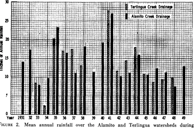
FIGURE 2. Mean annual rainfall over the Alamito and Terlingua watersheds during a 19-year period.
North of the Rio Grande and west of Alamito Creek are some dissected outwash gravelly loam soils. Although these soils origi- nally supported black grama; bush muhly (Muhlenbergia port- eri), Chino grama (Bouteloua breviseta), and Neally grama (Bouteloua uniflora), they are eroded to desert pavement in many places, and they are now dominated by creosote bush (Larrea tridentata), and mariola (Parthenium incanum).
A rock escarpment divides the two watersheds. It varies in height from 100 to 600 feet.
The headwaters of Terlingua Creek originate in numerous canyons with mesas between. The soils are loams with varying amounts of stone throughout the profile, 10 to 20 inches deep, over fractured basalt rock. The dominant vegetation on the mountain soils is composed of hairy grama, blue grama, side- oats grama and cane bluestem. Slopes are variable. The canyons have slopes over 60 percent while the mesas and ridges be- tween may average around 15 to 20 percent.
middle portion of the area. The average slope on the flat is about five percent. Soils are loams and clay loams over five feet deep. This flat at one time supported a good stand of tobosa grass and blue grama, with smaller colo- nies of sideoats grama and cane bluestem. In the main drainage ways giant sacaton (Sporobolus giganteus) could be found.
The southern portion of the watershed is an area of eroded clay loam hills with large areas covered with broken lava rocks. The major species of vegetation on this site are Chino grama, Neally grama, hairy grama, side- oats grama, lechuguilla (Agave Zechuguilla) and several other shrubs.
The outwash plains along the Chisos Mountains make up a small percentage of the area. The climax vegetation is principally the same as on the outwash plains in the Alamito Creek watershed.
Rainfall Characteristics
The 02 Flat, which makes up about one-fourth of the water- shed next to the escarpment on the west and northwest, is about 40 miles long. It covers the
The Big Bend is known for its erratic rainfall, and any rancher there may tell you he would be in “tip top shape” if he had just one more rain.
Most of the yearly rainfall comes during the growing season from June through October. The
yearly mean average rainfall over the entire watershed is about 14 inches. From 1931 through 1950 the yearly high was 32.38 inches on the Alamito Creek watershed, the low 6.95 inches. On the Terlingua Creek watershed the yearly high was 27.25 inches and the low 2.32 inches. Figure 2 shows the mean annual rainfall over both water- sheds from the best rainfall rec- ords available from the U. S. Weather Bureau, International Water and Boundary Commis- sion, Soil Conservation Service, and local rancher records.
The mean annual rainfall was computed from the records of ten stations on the Alamito Creek drainage and six stations on the Terlingua Creek drainage. These stations were selected be- cause of the uniformity of cov- erage in percent of the total watersheds.
Table 1. Wafer intake rates and production of forage by range condition fair condition, the same rain only
class on the Gravelly Loam Site, Highland Soil Conservaflon soaked into the soil to a depth
District, 1950. of 5 inches.
Excellent
Water intake-inches per hour 9.5
Pounds of forage per acre 1065
Range Condition
Good Fair
5.8 4.25
666 511
Poor 2.75 341
On an overflow site where runoff water was diverted onto rangeland from an arroyo, mois- ture penetrated to over 5 feet on good condition range. On range in poor condition moisture did not penetrate more than a foot. These measurements were taken after water flowed over the soil for approximately 20 hours.
During the winter of 1950 the author made a study on a ranch that had an overflow site near a rain gage. A fence separated two range condition classes that had been grazed at different inten- sities. There were 2.18 inches of moisture that fell in a five-week period at such a gentle rate that none ran off, and all was ab- sorbed by the soil where it fell (Table 2). Moisture penetrated the clay loam soil under both good and poor range conditions to a depth of 18 inches. Soil samples were taken once a week to the depth which moisture penetrated. The samples were oven-dried to determine the per- cent of moisture.
1.25 inches per hour. The local thunder storms seldom cover a large area, but often yield 2 to 3 inches of rain during one storm.
These local thunder storms fit the expression so often used, “Someone knocked a hole in the bottom of the bucket.” A large amount of water falls in a very short period of time and yields a large volume of runoff locally, which can cause severe erosion, especially on ranges in poor con- dition (Figure 3).
The storms that move in from the Gulf of Mexico generally cover an area that greatly ex- ceeds the size of the two water- sheds. These storms are of much lower intensity and of a longer duration. These storms often last for two and sometimes three days. For the period covered by this report there have been on the average two to three of these coastal storms over the area each year, and they yield, on the aver- age, l/2 to 2 inches of moisture.
Inf ilfr afion Studies
Infiltration rings were used to determine the correlation be- tween range condition and rate of water absorption by the soil (Leithead, H. L. 1950. Field methods used to demonstrate range condition. Jour. Range Mangt. 3:95-99.). This study was made on the gravelly loam and overflow sites. Data are present- ed on the gravelly loam site be- cause it was one range site where all four range condition classes could be found. The same cor- relation was found to exist be- tween range condition and rate of water absorption on the good, fair, and poor conditions on the overflow site, even though the
rate of absorption was corre- spondingly slower.
Water was absorbed at the rates shown in Table 1 on the four range condition classes on the gravelly loam site using in- filtration rings. Production of these same ranges was measured by plot clippings on I ungrazed pastures.
Field observations were made after many storms to check the depth of moisture penetration on the various range sites that sup- ported range in different condi- tion classes. A spade was used to check the depth of penetra- tion. When it was possible, sites were selected where a fence sep- arated range in two different condition classes. This was to eliminate the possibility of com- paring moisture penetration un- der different intensities and amounts of rain.
After one general rainstorm moisture penetrated to 30 inches on a loamy upland site in good condition. Across the fence, where the range was in a low
The soil supporting poor con- dition range that was closely grazed continued to lose mois- ture after it was first moistened, even though light showers con- tinued to fall (Table 3). The area
FIGURE 3. Water concentrating in an arroyo after a 3-inch rain that fell in 1.2 hours
near Valentine, Texas, June 25, 1938. When rains like this fall on poor condition range they cause a lot of damage. Soil and water losses are great from the area covered by
Table 2. Amount and disiribution of
rainfall on infiltration study area
during ihe period January 19-Febr-
uary 23, 1950. Inches of
Date Precipitation
January 19 .78
22 .44
23 .08
24 .lO
29 .23
February 1 .23
13 .18
23 .Ol
__-
Total precpltation 2 18
100 al
f 1 Terlingua Creek Drainage
I m Alamito Creek Drainage I
supporting good condition range that had been properly grazed maintained its soil moisture sup- ply for a long time.
1932 33 34 35 36 37 38 39 40 41 42 43 44 45 46 47 48 49 50 51
FIGURE 4. Acre-feet of water lost per square mile of drainage during a 20-year period on the Alamito and Terlingua drainages.
The soil that supported heavily used, poor-condition range lost on the average one-fourth inch of moisture per week. This loss was attributed primarily to evap- oration from the soil surface. There were light winds every few days, and for the most part the atmosphere was dry. The m ax i m u m daily temperatures were less than 70 degrees, which is too cold for active plant growth of warm season species such as blue grama, sideoats grama, and cane bluestem. These were the major species on the site in good condition. Fluff- grass (Tridens pulchellus), bur- rograss (Scleropogon brevi- folius), and annual three-awn were the major species on the poor-condition range.
lingua creeks. Therefore, it was decided to analyze this flow data to determine if a correlation ex- isted between range condition and runoff from these two water- sheds that were each over 1,000 square miles in area.
It should be brought out here that all dates showing any meas- urable amount of runoff above normal were checked against the rainfall records. The records showed that 9 out of 10 storms that were of such magnitude to produce a measurable amount of runoff were from coastal storms that covered both watersheds and yielded, on the average, more than .75 inch of moisture.
In a 2?&month period prior to
active plant growth the range in poor condition lost approximate- ly 74 percent of the moisture that had entered the soil. The range in good condition that had been properly grazed lost about 42 percent. The wilting coefficient of these soils is about 4.5 per- cent.
When storms covered less than one-third or one-fourth of either watershed, measured discharge from runoff was quite small. Coastal storms have usually con- tributed less than one-fourth of
Table 3. Percent of moisture in fhc
that supported range in different condition and intensifies of grazing, 1950.
Runoff and Condition The International Boundary and Water Commission had maintained water stage re- corders since January 1931, at the mouth of Alamito and Ter-
Date
January 19 21.15
February 2 26.44
8 23.75
18 23.92
24 23.20
April 7 15.22
the annual rainfall.
The recorded annual discharge in acre-feet per square mile of drainage on the Alamito and Terlingua Creek watersheds was computed from data taken from International Boundary and Water Commission Bulletins Nos. 2 through 21, 1933-1951, and is expressed in Figure 4. Low flows were based on meter meas- urements, and medium and high flows were a continuous record of gage heights and rating curve, the higher points of which were determined by meter measure- ment, computations by shifting channel methods. In analyzing this figure it should be kept in mind that a diversion dam was constructed across Calamity Creek and Chalk Draw into the Maravillas drainage. This re- duced the drainage area of Ter- lingua Creek by 219 square
firsf 18 inches of clay loam soil
Percent of moisture in the soil Good condition
range - lightly used
Poor condition range - heavily used
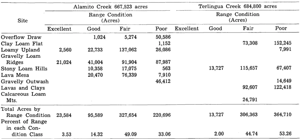
Table 4. Range condition by sites on ihe Alamito and Terlingua Creek Watershed.
Alamito Creek 667,523 acres ~ __ Terlingua Creek 684,800 acres
Range Condition Range Condition
Site (Acres) (Acres)
Excellent Good Fair Poor Excellent Good Fair Poor
Overflow Draw 1,024 5,274 50,586
Clay Loam Flat 1,152 73,308 152,245
Loamy Upland 2,560 22,733 137,062 26,086 7,991
Gravelly Loam
Ridges 21,024 41,004 91,904 87,987
Stony Loam Hills 10,358 17,075 563 13,727 115,657 67,407
Lava Mesa 20,470 76,339 7,910
Gravelly Outwash 46,412 14,649
Lavas and Clays 92,607 122,418
Calcareous Loam
Mts. 24,791
Total Acres by
Range Condition 23,584 95,589 327,654 220,696 13,727 306,363 364,710
Percent of Range in each Con-
dition Class 3.53 14.32 49.09 33.06 2.00 44.74 53.26
miles. In 1948 this diversion dam washed out and the runoff water from these two headwater drain- ages again flowed into Terlingua Creek.
The average yearly amount of moisture to leave the Alamito Creek watershed by runoff would amount to less than one- fourth inch of the total annual rainfall over the watershed. The Terlingua Creek watershed lost on the average about one-half inch of the annual rainfall by runoff.
In order to have a comparison of the range condition on each watershed, the author carried out a range site and condition survey in 1951, using the method developed by the Soil Conserva- tion Service. A large portion of the Alamito Creek watershed had been surveyed before that time for developing ranch con- servation plans. The Terlingua Creek watershed was not in an organized Soil Conservation Dis- trict until 1948. The range con- dition on Alamito Creek was checked in 1951. There were in- dications that the ranges were improving, but few of them had improved as much as one condi- tion class. Range improvement by natural plant succession in this area is, of course, slow.
There were nine major range sites recognized on these water- sheds. Table 4 gives an acreage breakdown of range condition by sites on each watershed.
Conclusions
Runoff is increased in the Davis Mountain-Big Bend area as ranges deteriorate in range condition because the soil ab- sorbs moisture slower. A range site in good condition absorbs moisture five to six times faster than the same range site in poor condition.
The loss of moisture by evap- oration from the first foot of soil is about three times greater on closely grazed, poor condition range than it is from the same sites in good condition that have been properly grazed. Moisture lost to evaporation can be just as serious as moisture lost by runoff, even though it is less noticeable.
Moisture lost by runoff on Alamito and Terlingua Creek drainages is from general storms that yield more than .75 inches of moisture per storm and cover more than two-thirds of the watershed. Alamito Creek has lost, on the average, over the 25- year period, about one-fourth
inch of the annual rainfall. Ter- lingua Creek lost about one-half inch of rainfall during the same period. However, it is question- able if the difference in runoff from these watersheds can be attributed altogether to the dif- ference in range condition, since comparable range does not oc- cur on each tiatershed in the same percentage. Although the soils are similar, there is a higher percentage of clay in the soils in three of the range sites found on Terlingua Creek.
Runoff from the local thunder storms does not leave the water- shed even though it leaves the area on which the rains fall. This runoff is absorbed in the dry beds of the arroyos, and very seldom reaches the gaging sta- tions at the mouths of these drainages.