Gravity structure of Akan composite caldera, eastern Hokkaido, Japan:
Application of lake water corrections
Takeshi Hasegawa1, Akihiko Yamamoto2, Hiroyuki Kamiyama3, and Mitsuhiro Nakagawa1
1Department of Natural History Sciences, Graduate School of Science, Hokkaido University, Sapporo, Japan 2Department of Earth Sciences, Graduate School of Science and Engineering, Ehime University, Matsuyama, Japan
3Institute of Seismology and Volcanology, Graduate School of Science, Hokkaido University, Sapporo, Japan
(Received October 1, 2008; Revised January 6, 2009; Accepted January 9, 2009; Online published August 31, 2009)
Akan volcano, eastern Hokkaido, Japan, is characterized by a rectangular-shaped caldera (Akan caldera: 24 km by 13 km) with a complex history of caldera-forming eruptions during the Quaternary. A new Bouguer anomaly map of the caldera is presented on the basis of a gravity survey around Akan volcano. As part of and in addition to this survey, we applied gravimetry over the frozen caldera lake including lake water corrections. The Bouguer map shows the distribution of at least three sub-circular minima indicative of multiple depressions inside the caldera. Lake water corrections, performed by a numerical integration method using rectangular prisms, sharpen edges of the sub-circular minima. This gravity feature is consistent with geological investigations suggesting that caldera-forming eruptions of Akan volcano occurred from at least three different sources. It is concluded that Akan caldera can be described as a composite caldera with three major depressed segments.
Key words:Gravity anomaly, Akan volcano, composite caldera, lake water correction.
1.
Introduction
Gravity studies have widely been used to constrain sub-surface structures and formation processes of caldera vol-canoes (e.g., Yokoyama and Ohkawa, 1986; Frogeret al., 1998; Gudmundsson and H¨ognad´ottir, 2007). These stud-ies demonstrate that calderas formed by explosive eruptions are generally marked by gravity lows that are interpreted as a lack of mass due to depression structures inside the caldera. In terms of gravity anomalies, however, most of these studies ignored the effect of caldera-filling lake wa-ter. Because terrain corrections are commonly computed by using digital elevation models (DEM), which lack wa-ter depth information of lakes, the Bouguer correction con-sists of the replacement of the lake water with rock mate-rial. These calculations lead to an overcompensation of the Bouguer anomaly, which depends on the size and depth of the caldera-filling lakes. Although several studies concern water effects caused by relatively large-sized caldera lakes (e.g., Davy and Caldwell, 1998), they do not show the cal-culating procedures in detail. Some studies also simplify the procedures by replacing lake geometry as an inverted flat-bottomed cone (e.g., Fournieret al., 2004). In the case of relatively small-sized lakes water effects have been ig-nored because it is likely that the correction may not change the overall trend of gravity structure. However, in order to discuss smaller-scale complex structure and related forma-tion processes of a caldera volcano, accurate and detailed gravity maps are needed.
Akan volcano, located in eastern Hokkaido, Japan
Copyright cThe Society of Geomagnetism and Earth, Planetary and Space Sci-ences (SGEPSS); The Seismological Society of Japan; The Volcanological Society of Japan; The Geodetic Society of Japan; The Japanese Society for Planetary Sci-ences; TERRAPUB.
(Fig. 1), has a rectangular-shaped caldera (Akan caldera: 24 km by 13 km) with a complex, long eruptive history of caldera-forming eruptions (Hasegawa and Nakagawa, 2007). Relatively small-sized caldera lakes (e.g., Lakes Akan, Panke-toh and Onne-toh: ∼a dozen km2in area) are present at the basin. Although the gravity investigation by Ohkawa and Yokoyama (1979) showed that Akan caldera is characterized by an oval-shaped gravity low, fine-scaled features remain unclear due to the lack of lake water cor-rections and poor spatial distribution of the gravity stations. In order to reveal the fine gravity structure and formation mechanism of the characteristic rectangular caldera, we per-formed additional gravity surveys (including those on the frozen lake) and quantitative lake water corrections. In this paper, we present a new gravity map of Akan volcano show-ing that the caldera is composed of at least three distinct de-pression segments. In addition, we discuss the significance of lake water corrections of caldera lakes.
2.
Geological Background
Akan volcano is situated at the southern end of Akan-Shiretoko volcanic chain, eastern Hokkaido, Japan (Fig. 1). It consists of a caldera (Akan caldera) and four post-caldera volcanoes. Somma lavas with K-Ar ages of 3.9–2.8 Ma (NEDO, 1992; Gotoet al., 2000) constitute the rim of Akan caldera, and these presumably represent pre-caldera stra-tovolcanoes. The basement of Akan volcano consists of Cretaceous-Tertiary sedimentary and volcanic rocks, part of which is characteristically exposed at the center of the caldera basin. Measured densities of the basement rocks were reported as 2.27×10³∼2.60×10³kg m−3(NEDO, 1992).
The construction of Akan volcano was initiated by
Fig. 1. (a) Simplified geological map of Akan volcano based on Hasegawaet al.(2006), and maps of (b) eastern Hokkaido and (c) Japanese Islands. Closed triangles and dashed lines in (a) represent major summits and topographic rim of Akan caldera, respectively. Triangles in (b) indicate major Quaternary volcanoes. Note that Cretaceous-Pliocene rocks are exposed at the basin of the Akan caldera. Abbreviations; OAK: Mt. O-Akan-dake, MAK: Mt. Me-Akan-dake, FUP: Mt. Fuppushi-dake, FRB: Mt. Furebetsu-dake, KIK: Mt. Kikin-dake, IYD: Mt. Iyudaninupuri-yama, LA: Lake Akan.
ing of the pre-caldera volcanoes, followed by large-scale caldera-forming activities. The caldera-forming activities continued for more than 1 million years (ca. 1.4–0.2 Ma: Hasegawa and Nakagawa, 2007), producing a large volume of pyroclastic flow and fall deposits (Akan pyroclastic de-posits) that are widely distributed around the caldera. These pyroclastic deposits are divided into 40 eruptive units, each separated by significant time intervals that are often marked by paleosols (Hasegawa and Nakagawa, 2007). Total erup-tive volume of the pyroclastic deposits is estimated to be more than 150 km3 DRE (Hasegawa et al., 2006). Post-caldera volcanoes were generated successively after the lat-est caldera-forming activity. Volcanic materials discharged from these post-caldera volcanoes widely filled the caldera basin, and then resulted in formation of several dammed lakes. Lake Akan, the largest of these caldera-filling lakes, has an area of 13 km2and maximum depth of approximately 50 m.
3.
Methods
3.1 Gravity survey
We obtained 15 gravity data on the frozen lake surface and 184 data on land using the Scintrex gravimeters (S227 and S315) with a precision of±0.05 mGal (reproducibility error). Elevations were determined using differential GPS positioning, spot heights and contours on 1/25,000 topo-graphic maps published by Geotopo-graphical Survey Institute
of Japan. This amounts to 509 gravity data points includ-ing published data of Geological Survey of Japan (GSJ) (2000, 2004) and unpublished data of Hokkaido University. The data were reduced for free-air and Bouguer corrections as well as for terrain effects imposing a density of 2.4× 10³kg m−3, which is the median value of actual densities of basement rocks of Akan volcano (NEDO, 1992). Terrain corrections are based on the method of Yamamoto (2002). 3.2 Lake water correction
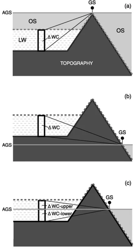
Fig. 2. Schematic illustration of the geometry of lake water corrections. The situations that need to be considered are those in which the altitude of gravity stations (AGS: light-gray solid horizontal lines) is (a) higher than that of lake surface, (b) lower than that of lake bottom, and (c) ranging from that of lake bottom to the surface. Topography and lake water (LW) are shown by dark shaded and crossbars-filled patterns, re-spectively. GS: gravity station, OS: open space (light shade patterns), WC: vertical column of lake water having the density difference of 1.4×10³(=2.4×10³–1.0×10³) kg m−3. Conventional terrain cor-rections are performed along the boundary between OS and LW/rocks (topography) bounded by solid dotted lines because DEM includes no water-depth information. The effects of LW are calculated by numerical integrals over vertical columns (WC) of lake water (LW), so that LW recovers over (or under) -corrected component of conventional terrain correction.
caused by one vertical prism at each gravity station on the basis of the ‘TC50’ program of Yamamoto (2002). The sum of the contributions from each rectangular prism pro-duces total lake water corrections in a single gravity station. Thus we can carry out the calculation of gravitational ef-fects of whole lake water (1.0 ×10³ kg m−3 in density) of Lake Akan by numerical integration in all gravity sta-tions. In practice, we considered the following three cases depending on the elevation difference between the gravity stations and the lake surface: (a) altitude of a gravity station (AGS) is higher than that of the lake surface, (b) AGS is lower than that of the lake bottom, and (c) AGS is ranging
from that of the lake bottom to its surface. Figure 2 shows a schematic illustration of the three different cases. Gravity correction idea is simple and as follows: Bouguer slab be-tween sea level and station model is made with terrain cor-rection at first, and Bouguer slab is removed with Bouguer correction later. Although the effects of open space (OS) should be terrain correction, lake water (LW) is not cor-rected with the conventional DEMs because no water-depth information is included in Japanese DEMs of topography. Therefore, the terrain correction values of LW in case (a) (mass deficit) and (b) (mass surplus) are positive and neg-ative, respectively. These over- and under-subtracted con-tributions should be recovered for TCWD as the lake water correction. This can be evaluated as a sum of the effect of rectangular prisms (WC) whose density is given by 1.4
×103kg m−3 (=2.4×10³ – 1.0×10³ kg m−3). In the case (c), both the cases (a) and (b) should be considered at the same time. This is becauseWC exists below and above AGS (Fig. 2(c)); it consists of positive and negative parts. In this case, WC-lower (below AGS) and WC-upper (above AGS) should be added to and subtracted from TCWD respectively.
4.
Results
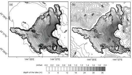
Figure 3(a) shows the contour map of estimated lake wa-ter corrections around Lake Akan. In this map, there is no area of negative values of lake effect (case (b) in Fig. 2). The pattern of equi-contour lines on the lake is very much similar to that of bathymetric map of the lake (Fig. 3(b)). The correction values are almost same, or a little small, as the lake depth multiplied with 1.4(2.4−1.0)by 0.04192 (2πG). The lake water effects gradually increase as water depth increases, and reach the largest value (about 2 mili-gals) at the eastern region of the lake, where water depth also reaches the maximum value (approximately 50 m). Outside the lake, the effects are mostly less than 0.1 mGal (The minimum effect value in studied area is about 1.0× 10⁻⁴ μGals). We also estimated lake correction by using 10 m grid spacing model of the lake, in order to assess the sensitivity for the grid resolution. There is no significant change of the contour map from that of 20 m grid model (maximum difference value at the same point is about 1.0
×10−1μGals).
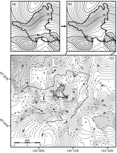
Figures 4(a) and (b) show a comparison of Bouguer anomaly maps around Lake Akan before and after the lake corrections, respectively. In both maps, two centers of low gravity are recognized at the south of Lake Akan. The lake water corrections remarkably changed the contour pattern of the region between the two lows; a high gravity ridge between the two sub-circular minima was emphasized, and separation of the two minima became more apparent. Dis-tribution of the gravity ridge separating the two minima is in accordance with surrounding geology; basement rocks narrowly exposed along the gravity ridge (Figs. 1 and 4).
1
0.0 0.2 0.4 0.6 0.8 1.0 1.2 1.4 1.6 1.8 2.0 (mGal)
0
depth of the lake (m) 6 12 18 24 30 36
(a) (b)
Fig. 3. Contour map showing the effect of lake water correction (a) and topographic map (b) around Lake Akan. Heavy black lines indicate coasts of Lake Akan and four islands (=420 m above sea level). The contour interval inside the lake of (a) is 0.1 mGal. The reduction density is 2.4× 10³kg m−3. Topographic contours inside and outside the lake of (b) are expressed as bathymetry and above sea level, respectively. The contour intervals of the former and the latter are 2 m and 20 m, respectively.
center of the caldera; (2) This value gradually increases towards topographic caldera rim and reaches its maximum around the rim; (3) The gravitational low region inside the caldera is composed of at least three sub-circular closed minima. The geometry of this minima is several kilometers long trending in a ENE-WSW direction. These features are also apparent when reduction densities of 2.2 × 10³ and 2.67×10³ kg m−3 are used (The maximum difference of Bouguer anomaly value at the same points when changing the reduction densities 2.2∼2.4×10³ kg m−3and 2.4∼ 2.67×10³kg m−3is about 10 mGal).
5.
Discussion
Gravity lows associated with silicic calderas are gener-ally attributed to the caldera infilling within depressed struc-tures by pyroclastic rocks (e.g., Yokoyama, 1963; Rymer and Brown, 1986). The new Bouguer anomaly map of Akan volcano shows that the caldera is characterized by three closed gravitational lows. This suggests that there are three distinct major depressions filled by pyroclastic rocks inside the caldera. A geological study of Akan pyroclastic de-posits (Hasegawa and Nakagawa, 2007) suggests that Akan caldera might be a composite one because of the rectangular shape and its long, complex eruptive history. Hasegawaet al.(2006) also inferred that Akan pyroclastic deposits were derived from at least three different vent areas, on the ba-sis of the method of component analyba-sis of lithic fragments used by Suzuki-Kamataet al.(1993) and Coleet al.(1998). These suggestions of geological studies are well consistent with the result of our gravitational investigation.
Although basement rocks are generally not exposed at the bottom of low gravity anomaly type calderas, there exist Tertiary basement rocks at the center of the basin of Akan
caldera. Distribution of the basement rock corresponds to the region of a gravitational ridge between two eastern sub-circular closed minima (Figs. 1 and 4), suggesting that the ridge of high gravity may be caused by a remnant mass of the denser basement rock. This basement rock can be interpreted as part of a buried caldera rim bounding the distinct caldera depressions.
On the basis of these gravity data combined with previ-ous geological studies, it is concluded that Akan caldera is a composite caldera, whose rectangular shape reflects a dis-tribution of spatially distinct, and relatively small calderas, trending east-west. Composite calderas evidenced by ge-ological and geophysical studies, especially by gravimetric study, were already reported in Japan (e.g. Aso caldera: Ko-mazawa, 1995). Another instance of a composite one is re-ported in Taupo volcano located on Taupo Volcanic Zone, North Island, New Zealand (e.g., Wilson, 1993; Coleet al., 1998; Davy and Caldwell, 1998).
Recently, Lipman (2000) and Cole et al. (2005) em-phasized that many calderas are geometrically complex, containing elements of more than a single structural type and formation processes envisaged by the classical piston and funnel models proposed after Williams and McBirney (1979) and Lipman (1997). Furthermore, multiple magma bodies rather than a single large one are increasingly recog-nized as an important element that leads to composite struc-tures with complex geometries (e.g., Reubi and Nicholls, 2005; Smithet al., 2005). The case of Akan caldera is one of the good examples supporting the recently-emphasized complex system of caldera formation.
75
L L
(a)
75
L L
(b)
(c)
KIK
IYD
FUP
FRB MAK
OAK
Fig. 4. Bouguer anomaly maps of Akan volcano: close views around Lake Akan (a) before and (b) after the lake water corrections, with contour intervals of 1 mGal, and (c) an overview after the lake water correction, with contour intervals of 2 mGal. Reduction density is 2.4×10³kg m−3. Solid lines indicate the coasts of Lake Akan. Hachured areas show a Bouguer gravity anomaly less than 60 mGal. Dots and triangles in (c) indicate gravity stations and major summits, respectively. See the caption of Fig. 1 for the abbreviations.
of correction generally tend to obscure a structure of low gravity anomaly type calderas. Since the maximum lake water effects are estimated to be 2 mGal even on a rela-tively small-sized Lake Akan (Fig. 3), greater changes of gravity features can be expected in case of relatively large-sized lakes. Caldera lake water is an obstacle for making gravity maps in terms of difficulty of measuring gravity on the lake surface and complicated procedure of water cor-rection. However, high-resolution gravity investigation in-cluding quantitative lake corrections is necessary, even for a small-sized lake, to determine exact gravity features of calderas, whose internal structures and formation processes
might not be simple but complex.
Acknowledgments. We thank J. R. Brown of the Department of Geophysics, Stanford University for reading our manuscript. Thanks are also due to the editor of EPS A. Takada, and to N. Fournier and anonymous reviewer for constructive comments. This study was supported by the Fukada Grant-in-Aid from Fukada Geological Institute.
References
Geotherm. Res.,80, 217–237, 1998.
Cole, J. W., D. M. Milner, and K. D. Spinks, calderas and caldera structure: a review,J. Volcanol. Geotherm. Res.,69, 1–26, 2005.
Davy, B. W. and T. G. Caldwell, Gravity, magnetic and seismic surveys of the caldera complex, Lake Taupo, North Island, New Zealand,J. Volcanol. Geotherm. Res.,81, 69–89, 1998.
Fournier, N., H. Rymer, G. Williams-Jones, and J. Brenes, High-resolution gravity survey: investigation of subsurface structures at Po´as volcando, Costa Rica,Geophys. Res. Lett.,31, L15602, doi:10. 1029/2004GL020563, 2004.
Froger, J.-L., J.-F. L´enat, J. Chorowicz, J.-L. Le Pennec, J.-L. Bourdier, O. K¨ose, O. Zimitoglu, N. M. G¨undogdu, and A. Gourgaud, Hidden calderas evidenced by multisource geophysical data; example of Cap-padocian Calderas, Central Anatolia,J. Volcanol. Geotherm. Res.,185, 99–128, 1998.
Goto, Y., A. Funayama, N. Gouchi, and T. Itaya, K-Ar ages of the Akan-Shiretoko volcanic chain lying oblique to the Kurile trench: Implications for the tectonic control of volcanism,Island Arc,9, 204–218, 2000. GSJ (Geological Survey of Japan),Gravity CD-ROM of Japan (CD-ROM),
Digital Geoscience Map Series P-2, Geol. Surv. Jpn., Tsukuba, Ibaraki., 2000.
GSJ (Geological Survey of Japan),Gravity CD-ROM of Japan (ver. 2) (CD-ROM), Digital Geoscience Map Series P-2, Geol. Surv. Jpn., Tsukuba, Ibaraki, 2004.
Gudmundsson, M. T. and Th. H¨ognad´ottir, Volcanic systems and calderas in the Vatnaj¨okull region, central Iceland: Constraints on crustal struc-ture from gravity data,J. Geodyn.,43, 153–169, 2007.
Hasegawa, T. and M. Nakagawa, Stratigraphy of Early to Middle Pleis-tocene pyroclastic deposits around Akan caldera, eastern Hokkaido, Japan,J. Geol. Soc. Jpn.,113, 53–72, 2007 (in Japanese with English abstract).
Hasegawa, T., E. Ishii, and M. Nakagawa, Evolution of Akan Caldera, East Hokkaido, indicated by analysis of lithic fragments in pumice fall deposits,The Earth (Chikyu) Monthly,28, 283–289, 2006 (in Japanese). Komazawa, M., Gravimetric analysis of Aso Volcano and its interpretation,
J. Geod. Soc. Jpn.,41, 17–45, 1995.
Lipman, P. W., Subsidence of ash-flow calderas: relation to. caldera size and chamber geometry,Bull. Volcanol.,59, 198–218, 1997.
Lipman, P. W., Calderas, inEncyclopedia of Volcanoes, edited by H. Sig-urdssonet al., 643–662, Academic Press, San Diego, 2000.
NEDO (New Energy and Industrial Technology Development
Organiza-tion), Akan area,Report of Geothermal development promotion survey, 26, 1133 pp., New Energy and Indus. Technol. Dev. Org., Kawasaki, Kanagawa, 1992 (in Japanese).
Ohkawa, S. and I. Yokoyama, Subsurface structure of Akan caldera based on gravity anomalies,Geophys. Bull. Hokkaido Univ.,38, 17–29, 1979 (in Japanese with English Abstract).
Reubi, O. and I. A. Nicholls, Structure and dynamics of a silicic mag-matic system associated with caldera-forming eruptions at Batur Vol-canic Field, Bali, Indonesia,J. Petrol.,46, 1367–1391, 2005.
Rymer, H. and G. C. Brown, Gravity fields and the interpretation of vol-canic structures: geological discrimination and temporal evolution,J. Volcanol. Geotherm. Res.,27, 229–254, 1986.
Smith, V. C., P. Shane, and I. A. Nairn, Trends in rhyolite geochemistry, mineralogy and magma storage during the last 50 kyr at Okataina and Taupo volcanic center, Taupo Volcanic Zone, New Zealand,J. Volcanol. Geotherm. Res.,148, 372–406, 2005.
Suzuki-Kamata, K., H. Kamata, and C. R. Bacon, Evolution of the caldera-forming eruption at Crater Lake, Oregon, indicated by component anal-ysis of lithic fragments,J. Geophys. Res.,98(B8), 14059–14074, 1993. Wessel, P. and W. H. F. Smith, New version of the generic mapping tools
released,EOS Trans. AGU,76, 329, Suppl., Aug. 15, 1995.
Williams, H. and A. R. McBirney, Calderas and cauldrons, inVolcanology, 207–238, Freeman, Cooper and Co., San Francisco, 1979.
Wilson, C. J. N., Stratigraphy, chronology, styles and dynamics of late Quaternary eruptions from Taupo volcano, New Zealand,Phil. Trans. R. Soc. London,A343, 205–306, 1993.
Yamamoto, A., Spherical terrain corrections for gravity anomaly us-ing a digital elevation model gridded with nodes at every 50 m,J. Fac. Sci. Hokkaido Univ.,11, 845–880, http://eprints.lib.hokudai.ac.jp/ dspace/bitstream/2115/8866/1/11%286%29 p845-880.pdf, 2002. Yokoyama, I., Volcanic calderas and Meteorite craters with the special
relation to their gravity anomalies,J. Fac. Sci. Hokkaido Univ.,2, 37– 47, 1963.
Yokoyama, I. and S. Ohkawa, The subsurface structure of the Aira Caldera and its vicinity in southern Kyushu, Japan,J. Volcanol. Geotherm. Res., 30, 253–282, 1986.