Published by Central Fisheries Research Institute (SUMAE) Trabzon, Turkey in cooperation with Japan International Cooperation Agency (JICA), Japan
R E S E A R C H P A P E R
Tracking Skipjack Tuna Fishing Ground in West Banda Sea relations
with Sea Surface Temperature Parameters from Aqua MODIS
Satellite
Muslim Tadjuddah
1,*1University of Halu Oleo, Fisheries Cupture, Southeast Sulawesi, Indonesia.
Article History
Received 08 September 2017 Accepted 28 March 2018 First Online 02 April 2018
Corresponding Author
Tel.: 628128932030
E-mail: [email protected]
Keywords
Fishing ground Skipjack Tuna
Sea Surface Temperature West Banda Sea
Abstract
Skipjack tuna is one of the most important economical fish and is found in almost all Indonesian waters. The skipjack tuna fishing ground in Southeast Sulawesi located around of Minui island waters and western waters of Banda sea. The purpose of this research is to analyze sea surface temperature at location fishing ground skipjack tuna using satellite data of Aqua MODIS then mapping of location points fishing ground. The study was conducted for three months, from May to July 2014. Recording of fishing ground positions is performed on every fishing operation using GPS. The results showed that around of skipjack fishing ground found the highest SST in May with a temperature of 31.64°C and the lowest in June with a temperature of 25°C. The highest CPUE was obtained on June 13, 2014, with a total of 101 tail with an average temperature of 27.59°C while CPUE occurred on June 13, 2014, with a total of 72 tails with an average temperature of 26.45°C. From results of tracking of fishing ground shows skipjack tuna fishermen in every fishing operation actually has a fishing orientation based on the existence of fish and from the experience of conducting fishing operations in the area that has been done continuously.
Introduction
Fishery resources of large pelagic fish in the northwest of Banda Sea is abundant. One of abundant fish resources such as skipjack tuna. Skipjack tuna (Katsuwonus pelamis) in the west waters of Banda Sea is one of the most important economical fish, where these skipjack tuna fishing activities have grown year by year (Wild and Himpton, 1994 in Sala, 1999). In general, the length of skipjack tuna caught in Indonesian waters ranges from 40-60 cm, at the age of one year in length approximately 37 cm, in the second year can reach 46 cm, third-year 55 cm, the fourth year 64 cm, the fifth year 72 cm and even skipjack tuna can reach a length of one meter at the age of more than seven years weighing 25 kg (Tadjuddah, 2005). The length of skipjack tuna caught in the study location ranged from 36.54-51.30 cm with the growth pattern L∞ = 70.1 cm and K = 0.260, would reach the value of L∞ at their age of 45.5 months or 3.7 years (Tadjuddah M., Anadi L., Mustafa A., Arami H., Abdullah, Kamri S., & Wianti N. I., 2017). Furthermore, according to Laevastu and Hela (1970) states that the distribution of skipjack tuna in the waters
is determined by various factors, both internal factors of the fish itself such as age, behavioral size and genetic factors that cause differences in morphology and external factors from the environment such as temperature, salinity, density and thermohaline depth, currents, water circulation, oxygen and food abundance. Swimming layer of skipjack tuna varies depending on the type and size of the fish. Skipjack tuna generally caught at a depth of 0-400 m, preferred salinity of 32-35‰ and temperature ranged from 17-31°C
catching is best done at a brightness level of 15 m to 30 m. In Indonesia's eastern waters itself, the brightness level in some fishing ground ranges from 10-30 m.
In utilization of these capture fishery resources, availability on potential fishing ground provides benefits as a decisive factor in the success of fishing operations. Other determinants such as oceanographic parameters including sea surface temperature, chlorophyll-a, and the use of appropriate methods and capture technology as well. Sea surface temperature observation is carried out by utilizing satellite image generated from the Aqua MODIS satellite (Tadjuddah, Mustafa, Pangerang, & Yasidi, 2012).This study tried to provide information about oceanographic parameters such as sea surface temperature (SST) which was adjusted to date and time of fishing and to conduct tracking fishing ground starting from fishing base to fishing ground. This effort was carried out in the hope that sustainable fisheries resources management would be achieved in the west of Banda Sea. This research aimed (a) to identify the parameters of sea surface temperature around the west waters of Banda Sea based on time and date, including month of capture, (b) to perform tracking skipjack tuna fishing ground based on the position (Lat/Lon) during the capture previously recorded.
Materials and Methods
Time and Location
This research was carried out during three months, in May, 2014 until July, 2014 which is the peak season of skipjack fishing in west waters of Banda Sea, in Province of Southeast Sulawesi, and the position was at 2°25' - 4°25' S and 122°75' - 124°00' E (Figure 1).
Materials which were used in this research were (Table 1) among others:
Data image of sea surface temperature derived from Aqua MODIS satellite was 2nd level daily data that has been geometric and radiometric corrected from May until July 2014. The process of downloading Aqua MODIS satellite data was adjusted to the date of fishing operation was held. by using pole and line, enumerator then records coordinates fishing grounds using GPS and calculates the number of catches at each catching setting and at each fishing ground, fish caught are skipjack tuna that appears to surface of the waters interested in the bait dispersed in the waters. Catch per unit effort is calculated using of fishing vessel units. Process of cropping and processing SST image data using software seaDAS 7.2 which is operated in windows program by using canal 31 and 32 from satellite MODIS using the algorithm which already exists in menu seadisp that is sst algorithm is as follows: modis_SST = c1+c2*T31-32+c4*(sec (Ø)-1)*T31-32, where T31 and T32 are brightness temperature from canal 31 and 32, Ø is angle zenith satellite (Minnet and Brown, 2001; NASA. 2015), while to get the ASCII value for the dominant temperature and temperature range using Microsoft Excel 2013.
Results
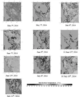
Distribution of SST Around of Skipjack Tuna Fishing Ground
In May 2014, average SST around skipjack tuna fishing ground was found around 28.58°C, meanwhile on date of May 5th, variation SST ranged from 26.00-31.64oC. SST spread dominantly almost evenly in the
Turk. J. Fish.& Aquat. Sci. 19(3), 191-197
eastern part of Southeast Sulawesi, the image of May 7th, 2014 showed SST variation ranged from 26.00-30.95oC, while in the image on May 9th, 2014 SST variation ranged between 26.00-29.67oC. In general, the movement of SST from day to day in May 2014 showed that there was a symptom of decreased sea water
temperature, therefore it looked more progressively the east the lower SST (Figure 2).
The image on June, 2014 showed the average SST was about 26.68oC. In June, 2014 the average SST image looked significantly decreased when compared to average SST image in May, 2014. On June 7th, 2014
Table 1. Materials which were used in this research were (Table 1) among others
No Materials Utilization
1 Materials :
- SeaDAS 7.2 - Google Earth
- GPS - Binoculaire - Pole and line fishing gears
- Microsoft Excel 2013
To process the Sea Surface Temperature data
To track the DPI To determine the position
fishing ground To detect skipjack tuna
schooling To catch skipjack tuna
fishes To analyze and visualize Sea Surface Temperature
data
2 Data:
- Sea Surface Temperature data which were acquired by cloud free Aqua MODIS satellite in May-July, 2014 (daily data) 2nd level, resulted of downloading from URL
http://www.modis.gsfc.nasa.gov
- The position (Lat/Lon) of skipjack tuna fishes fishing area
average SST showed variation between 25.15-29.19oC. The image on June 9th, 2014 showed the average SST variation ranged from 25.00-28.89oC. The image on June 11th, 2014 showed the average SST variation ranged from 25.03-27.21oC. While the image on June 13th, 2014 showed the average SST variation ranged between 25.00-29.36oC. The distribution of SST in June indicated cold temperatures began to flatten around northwest waters of the Banda Sea.
In July, 2014 average SST around skipjack tuna fishing ground was 26.15oC, while the dominant SST was found between 25.00-28.15°C. Comparing to May and June images, the SST image in July looked cooler than SST image in both months. However, for warmer temperatures the SST image appeared warmest temperature in May compared to SST images in June and July at the northwest waters of the Banda Sea. In general, the movement of cold temperatures moved dynamically to the east waters of the Banda Sea, while the warm temperatures which had seen in May look gradually faded and were replaced by cold temperatures which moved to the east (Figure 2).
Spacial and Temporal Pattern in Skipjack Tuna Fishing Ground in West Waters of Banda Sea
Tracking skipjack tuna fishing ground in special
and temporal manner were carried out to identify accurately the movement of fishes from the coordinate position of a fishing area and to know the number of catches from the point of fishing area temporarily. This study was conducted to analyze the movement of skipjack tuna fishing positions in the west waters of Banda Sea in May, June and July 2014.
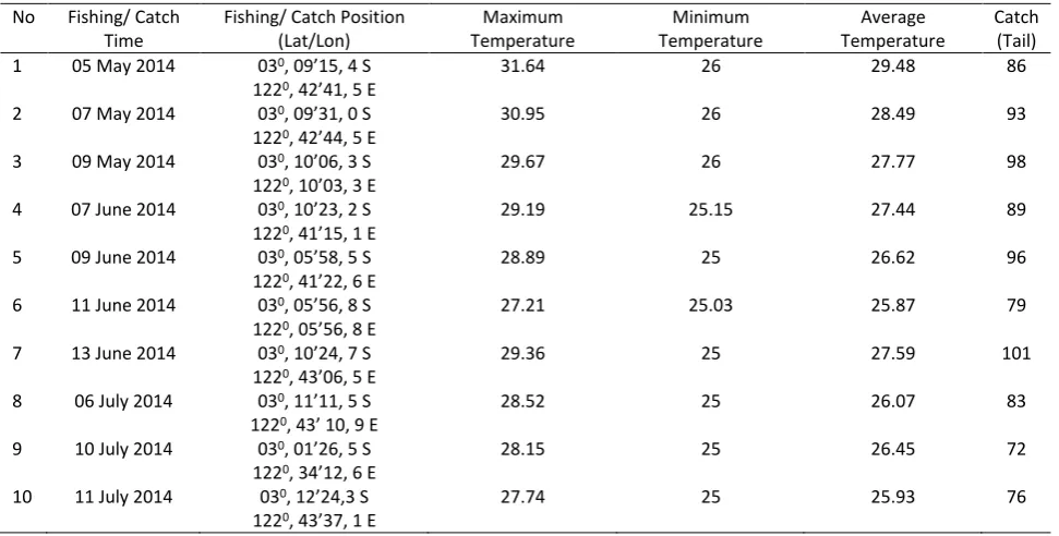
In May 2014, there were three points of skipjack tuna fishing positions held on May 5th, 7th and 9th, 2014. The fishing position on May 5th, 2014 was at 030, 09"15, 4 'S 1220, 42" 41, 5' E, and total number of catches was 86 tails. The fishing position on May 7th, 2014 was at 030, 09'31, 0 S1220, 42'44,5 E and gained the number of catches of 93 tails. While the fishing position on May 9th , 2014 was at 030, 10"06, 3 'S 1220, 10" 03, 3, and the number of catches was 98 tails.
In June, four fishing positions were found on June 7th, 9th, 11th, and 13th, 2014. The catch position on June 7th, 2014 was at 030, 10"23, 2 ' S 1220, 41" 15, 1 'E, and the number of catches was 89 tails. The catch position on June 9th, 2014 was at 030, 05 "58, 5 ' S 1220, 41" '22, 6 E, and the number of catches was 96 tails. While on June 11th, 2014, the catch position was at 030, 05 "56, 8 'S 1220, 05" 56, 8' E, and the number of catches was 79 tails and on June 13th, 2014 the catch position was at 030, 10 "24 , 7 'S 1220, 43'06, 5 E, and the number of catches was 101 tails.
Turk. J. Fish.& Aquat. Sci. 19(3), 191-197
In July 2014, there were three skipjack tuna fishing area positions were found on July 6th, 10th, and 11th, 2014. On June 6th, 2014 the fishing position was at 030, 11 "11, 5 'S 1220, 43" 10, 9' E, and the number of catches was 83 tails. On July 10th, 2014, the fishing position was at 030, 01, 26, 5 'S 1220, 34'12, 6 E, and the number of catches was 72 tails. While on July 11th, 2014 the fishing position was at 030, 12 "24.3' S 1220, 43" 37, 1 ' E, and the number of catches was 76 tails, as shown in Table 2.
The orientation fishing of skipjack tuna in spatial and temporal manner in May and June, 2014 showed that the orientation pattern of skipjack tuna fishing ground was on the east side of Labengki island and the west of Minui island. On the other side, the skipjack tuna fishing orientation in June, 2014 tended to shift going into north of Labengki island, whereas in July the orientation pattern of skipjack tuna fishing area was going into the west of Labengki island. Yet in this month it indicated that skipjack tuna fishing position started to show dispersed pattern from previous months. From these three orientation patterns, it indicated that the orientation pattern of skipjack tuna fishing ground in the west waters of the Banda Sea had a similar trend in every month that was located in the west of Labengki island. A slightly different orientation in July 2014, but orientation pattern tended towards the west of Labengki island. Tracking of skipjack tuna fishing areas in the west waters of Banda Sea in May, June and July as shown in Figure 3
Discussion
During the observation period towards SST images in the west waters of the Banda Sea it was found that
in general the lowest SST occurred in June, 2014 and the highest was in May, 2007. The results of this study are in line with research conducted by Tadjuddah, et al (2012) conducted around waters the islands of Wakatobi stating that the lowest sea surface temperature was found in June. The low temperature of SST in June, 2014 was estimated due to the influence of the east monsoon between June-July, while in May much due to transition season where the intensity of irradiation on the water surface was relatively stronger.
In general demonstrating, warm temperatures around the waters of the Banda Sea are occurred in May, while in June warm temperatures begin to show a decline, and this continues until July. The decrease of SST was in accordance with Tadjuddah (2015) research result which showed that in July which was the second month in east season, where the water temperature tend to be cooler than the previous month. Further supported by the statement Boely et al (1995). In Tadjuddah (2015) stated that the lowest temperature waters in the Banda Sea that is in the east season that took place in June, July and August so that this season allows the discovery of upwelling events. This statement was supported by Nontji (1993) which stated that in the waters of the Banda Sea, upwelling permits occured and reached the maximum for the east season.
Furthermore, in May 2014, on the image, the cooler water masses around the west waters of the Banda Sea were surrounded by warmer water masses, whereas in July 2014 the water masses pockets were no longer seen to melt into a cooler water mass. This event can be explained by the statement of Tadjuddah (2015), which stated that it occurred because of the change of warm water mass with cold water mass that
Table 2. Distribution of sea surface temperature and skipjack tuna fish caught
No Fishing/ Catch Time
Fishing/ Catch Position (Lat/Lon) Maximum Temperature Minimum Temperature Average Temperature Catch (Tail) 1 05 May 2014 030, 09’15, 4 S
1220, 42’41, 5 E
31.64 26 29.48 86
2 07 May 2014 030, 09’31, 0 S
1220, 42’44, 5 E
30.95 26 28.49 93
3 09 May 2014 030, 10’06, 3 S
1220, 10’03, 3 E
29.67 26 27.77 98
4 07 June 2014 030, 10’23, 2 S
1220, 41’15, 1 E
29.19 25.15 27.44 89
5 09 June 2014 030, 05’58, 5 S
1220, 41’22, 6 E
28.89 25 26.62 96
6 11 June 2014 030, 05’56, 8 S
1220, 05’56, 8 E
27.21 25.03 25.87 79
7 13 June 2014 030, 10’24, 7 S
1220, 43’06, 5 E
29.36 25 27.59 101
8 06 July 2014 030, 11’11, 5 S
1220, 43’ 10, 9 E
28.52 25 26.07 83
9 10 July 2014 030, 01’26, 5 S
1220, 34’12, 6 E
28.15 25 26.45 72
10 11 July 2014 030, 12’24,3 S
1220, 43’37, 1 E
began to dominate almost in the entire waters of the west of the Banda Sea.
In May, 2017 the highest number of caught fishes was on May 9th, 2014 with an average temperature of 27.77°C and CPUE of 98 tails, while the lowest number of caught fishes was on May 5th, and average temperature was 29.48°C with CPUE was 86 tails. In June, 2014 the highest number of caught fishes was on June 13th, and average temperature was 27.59°C with CPUE was 101 tails. The lowest number of caught fishes was on June 11th, and average temperature was 25.87°C with CPUE was 79 tails. In July, 2014 the highest number of caught fishes was on July 6th, and average temperature was 26.07°C with CPUE 83 tails. Meanwhile the lowest number of caught fishes was on July 10th with an average temperature was 26.45°C and CPUE was 72 tails. The high catch in June compared
with the May and July month catches was in line with the results of Tadjuddah (2017) study which showed that in the eastern season (June, July and August) the skipjack tuna catches were more abundant with larger catch sizes than previous seasons.
It can be explained generally that based on the number of catches showed that skipjack tuna in the west waters of the Banda Sea tended to enjoy waters with a cooler temperature range. Then Simbolon and Halim (2006) stated that the fluctuation of CPUE in fishing operations are largely determined by oceanographic conditions affecting the life and existence of fish, availability of food sources and different weather conditions each month.
Turk. J. Fish.& Aquat. Sci. 19(3), 191-197
there was a similar pattern of catching orientation around southern of Labengki island. In July 2014 the pattern of catches orientation seems slightly different, but in fact the orientation pattern in this month still lead to the south of Labengki island. From the tracking of the skipjack tuna fishing ground, it can be explained that actually the skipjack tuna fishermen in this area already had fishing orientation in every month in every catching season based on the existence of fishes and from the experience of conducting catching continuously operation in the area.
Acknowledgements
We would like to thank Directorate of Research and Community Service, Ministry of Research and Higher Education (Kemenristek-DIKTI) who fund this research with SKIM MP3Ei PERPRIMNAS fiscal year 2015, and to my all students who helped in data collection. This article was presented on Scientific Annual Meeting National XIII Indonesian Association of Oceanologists, held on 01-02 December 2016 in Surabaya, Indonesia
References
Blackburn, M. (1965). Oceanography and the Ecology of Tunas, In H. Barnes (Eds), Oceanography and Marine Biology Annual Revue, No. 3, (pp 299-322)
Demena, J E., Miswar E., & Musman, M. (2017). The Determination Of Potential Fishing Area Of Skipjack Tuna (Katsuwonus Pelamis) using Satellite Imagery in the Waters of South Jayapura, Jayapura City, Jurnal Ilmiah Mahasiswa Kelautan dan Perikanan Unsyiah . Vol 2, No 1: 194-199 pp http://jim.unsyiah.ac.id/fkp/article/view/2774
Husair, Tadjuddah, M. Abdullah, La Anadi, Mustafa A, & Arami, H. (2015). Analysis of Skipjack Tuna Catch
(Katsuwonus pelamis) On Fishing Ground in the West
Banda Sea. Proceding of the National Symposium on Sustainable Fishing Tuna Management (pp 103-114). WWF Indonesia Publisher 1259 pp
Minnet ER, & Brown O. (2001). Terra Sea Surface Temperature Thermal (SST) and Mid-Infrared (SST- 4).http://modarch.gsfc,nasa.gov/MODIS/ATBD/atbd-MOD-25.pdf/.html.
NASA. (2015). Ocean Color. Retrivied from http://www.oceancolor.gsfc.nasa.gov.html
Nontji, A. (1993). Laut Nusantara. Jakarta: Publisher Djambatan. 368 pp.
Kakiay,T.J. (1965).The Spread and Movement Skipjack Tuna around Waters of Tanjung Nusaniwe-Tanjung Alang during November-February (1964-1965) [In Bahasa] (MSc Thesis) Bogor Agricultural University, Bogor, Indonesia
Laevastu, T, & Hela. (1970). Fisheries Oceanography and
Ecology : London,Fishing News Book Ltd. 238 p
Simbolon D., & Halim, A. (2016). Sea Surface Temperature Relation with Skipjack Tuna and Yellowfin Tuna Catch in West Sumatra Waters. PSP Bulletin, Department of PSP. Faculty of Fisheries and Marine Sciences, Bogor Agricultural University. 15 (3): 122-138 http://journal.ipb.ac.id/index.php/jpsp
Suhentrata, T., & I.G.S. Merta (1986). Length-Weight Relationships, Gonad Maturity Level, and fecundity of skipjack tuna (Katsuwonus pelamis Linneus) in Sorong Waters. Marine Fisheries Research Journal 34: 11-19p http://issn.lipi.go.id/issn.cgi?daftar&1474602564&501 &&2016
Tadjuddah, M. (2017). Mapping of Fishing Ground and Remote Sensing in Wawonii Island West of Banda Sea, Bogor Indonesia, Publisher IPB Press, 102 pp
Tadjuddah M., Anadi L., Mustafa A., Arami H., Abdullah, Kamri S., & Wianti N. I., (2017) Growth pattern and size structure of skipjack tuna caught in Banda Sea, Indonesia. AACL Bioflux 10(2):227-233.pp
http://www.scopus.com/inward/record.url?eid=2-s2.0 85016406547&partnerID=MN8TOARS
Tadjuddah, M., Mustafa, A, Pangerang, U.K, & Yasidi F. (2012). Application of satellite multi-sensor techniques to detect upwellings and potential fishing grounds in Wakatobi Marine National Park, Southeast http://dx.doi.org/10.1080/14634988.2012.709814 Tadjuddah,M. (2005). Analysis of skipjack tuna and
madidihang fishing ground by using satellite data in the waters of Wakatobi Regency Southeast Sulawesi [In Bahasa] (MSc Thesis) Bogor Agricultural University, Bogor, Indonesia
Tampubolon, N.(1990).Study of skipjack tuna and thunnus sp
fishing and possible development in Pelabuhan Ratu, West Java. [In Bahasa] (MSc Thesis) Bogor Agricultural University, Bogor, Indonesia