www.geosci-instrum-method-data-syst.net/5/143/2016/ doi:10.5194/gi-5-143-2016
© Author(s) 2016. CC Attribution 3.0 License.
The abandoned surface mining sites in the Czech Republic:
mapping and creating a database with a GIS web application
Richard Pokorný and Marie Tereza Peterková
Faculty of Environment, Jan Evangelista Purkynˇe University, Králova Výšina 3132/7, Ústí nad Labem, 40096, Czech Republic
Correspondence to: Richard Pokorný ([email protected])
Received: 11 January 2016 – Published in Geosci. Instrum. Method. Data Syst. Discuss.: 26 January 2016 Revised: 5 April 2016 – Accepted: 14 April 2016 – Published: 19 May 2016
Abstract. Based on the vectorization of the 55-volume book series the Quarry Inventories of the Czechoslovak Repub-lic/Czechoslovak Socialist Republic, published in the years 1932–1961, a new comprehensive database was built com-prising 9958 surface mining sites of raw materials, which were active in the first half of the 20th century. The mapped area covers 40.9 % of the territory of the Czech Republic. For the purposes of visualization, a map application, the Quarry Inventories Online, was created that enables the data visual-ization.
1 Introduction
The sites of former surface winning of mineral raw materials mirror a notable part of the heritage of every nation. They provide an overview of cultural, economic, and industrial history; they enable the study of architecture and arts; they reflect development and maturity of technologies; and they can also serve the geoscientific education of the important sites of national geoheritage (Petersen, 2002; López-García et al., 2011). Finally, they represent remarkable objects from the point of view of landscape ecology (Raška et al., 2011). In particular, small quarries in towns or villages used to be left for natural succession, and nowadays they represent im-portant refugia increasing the biological diversity.
2 History of the surface mining sites in the Czech Republic
The registration of surface mining sites in the territory of the Czech Republic has a long tradition dating back to the
turn of the 19th and 20th centuries. The catalogue Österre-ichs Steinbrüche, written in German, seems to be the oldest comprehensive list of surface mining sites in the territory of the Austro-Hungarian Empire. It mentions 1502 quarries, of which 625 are located in today’s Czech Republic (436 in Bo-hemia, 86 in Moravia, 103 in Silesia) (Hanisch and Schmid, 1901).
In 1918, after the establishment of the independent Re-public of Czechoslovakia, the distinguished Czech scientist, geologist, and contemporary head of the Czech Geological Survey (formerly the State Geological Survey of the Repub-lic of Czechoslovakia, later renamed the Central Geologi-cal Institute) Cyril Purkynˇe (1862–1937) started an extensive project, the Quarry Inventories of the Czechoslovak Repub-lic/Czechoslovak Socialist Republic (in Czech Soupisy lom˚u
ˇ
CSR/ ˇCSSR, hereinafter referred to as “Quarry Inventories”). The main object of the mapping was to create the catalogue of the occurrence of both abandoned quarries and locations where the mining was running. It should have given a view of the occurrence, estimated quality, and prediction of thickness and possibilities of resource utilization. Further, it should have enabled estimating the areal extension of the needed raw materials in the given area, to assess the traffic accessi-bility and so on. Aside from the quarries, other types of sur-face mining sites were also objects of interest, e.g. clay pits, loam pits, sand pits, and gravel pits. The newly established “quarry department” of the State Geological Survey was en-trusted with mapping and with the formation of the Quarry Inventories (Purkynˇe, 1933).
144 R. Pokorný and M. T. Peterková: The abandoned surface mining sites in Czech Republic
1951. Forty-one of them were mapped (Gotthard, 1932; Vachtl, 1933, 1934a, b, 1935, 1947, 1949a, b; Kratochvíl and Zabloudil, 1934; Urban, 1935; Procházka, 1939; Soukup, 1940; Tuˇcek, 1940; Vavˇrínová, 1940, 1946, 1948a, 1949, 1950; Žebera, 1941; Hejtman, 1942, 1948a, b; Rost, 1942; Polák, 1946a, b, c, 1948a, b, 1949; Pauk, 1947; Pokorný, 1947, 1948, 1950; Prokop, 1948, 1949a, b; Kalášek and Polák, 1950; Šob, 1950; Prokop and Vachtl, 1951), for the following two districts separate supplements were published (Pauk, 1948; Vavˇrínová, 1948b), and one district belongs to the Slovak Republic nowadays (Fiala, 1934).
The area of interest in the single volumes of the Quarry Inventories was unified according to map sheets on a scale of 1:75 000 in the period 1947–1961, whereas in sporadic cases duplicate mapping of the already processed area was performed. In such cases the data were updated in the new volume – for instance when the quarry was no longer func-tioning, or when a newly opened mining site was detected next to an already known object, when new details on mining were obtained. In this period, 13 map sheets were mapped and published (Polák, 1951a, b, 1956; Vavˇrínová, 1951, 1952, 1961; Frejková, 1952; Kalášek, 1952; Prokop, 1952; Vavˇrínová and Líbalová, 1959; Líbalová, 1961a, b; Fajst and Holásek, 1961).
Concurrently to the Quarry Inventories project, primar-ily targeted on the Bohemian part of Czechoslovakia, 20 map sheets named “Map of the Building Materials in the Czechoslovak Republic” (in Czech Mapa stavebných hmôt
ˇ
Ceskoslovenskej republiky) were edited in Slovakia by the – at that time still independent – State Geological Insti-tute in Bratislava. Only a part of this set of 20 map sheets were printed in the form of an explanatory text to the Quarry Inventories (Katyk, 1949, 1950a, b, 1951a, b, c, d, e; Zorkovský, 1951); the rest are located as author manuscript map sheets at ˇCGS – department Geofond.
Single volumes of the Quarry Inventories project were published in the form of sewn-bound, hardbound, or paper-back booklets in A5 size (or similar). In the exordium, basic data concerning the geology of the mapped area and the his-tory of preceding research in the area of interest are briefly summarized. Lists of surface mining sites represent the cen-tral part of each volume. The lists are aligned according to appropriate cadastral areas, and they describe about 20 char-acteristic of the mining site, using a unified template. Men-tioned are the owner of the site, mileage to the nearest railway station, form of the access road, petrographic name of the rock, geological period, colour, granularity, porosity, hard-ness, polishability, method of mining, size of the site, number of employees, annual amount extracted, etc. The list of re-markable buildings where constructional materials from the site were used is an important but not always mentioned cat-egory.
The volumes have separate appendices – schematic or to-pographic maps of former districts or map sheets. Some of the volumes of the Quarry Inventories also contain attached
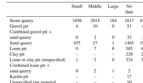
Table 1. Size characteristics of the mining sites. Small: up to 1000 m2; medium: 1000–10 000 m2; large: above 10 000 m2. Note: “–” is the category of mining sites not classified in detail.
Small Middle Large No 6 data
Stone quarry 3498 2014 184 1017 6713
Gravel pit 4 10 0 51 65
Combined gravel pit+
sand quarry 0 2 0 33 35
Sand quarry 455 27 1 1465 1948
Loam pit 0 7 8 585 600
Clay pit – – – 228 228
Loam or clay pit (unspecified) 1 2 0 334 337 Combined loam pit+
sand quarry 0 2 1 2 5
Kaolin pit – – – 17 17
Unspecified raw material – – – 10 10
sections that – on a smaller scale – illustrate selected parts of the surveyed area with a higher density of mining sites.
At the beginning of the 1960s, the quarry department of the State Geological Survey was abolished and the project Quarry Inventories was terminated without having mapped the whole territory of Czechoslovakia. We may assume that the reason for the shutdown was the fact that for commu-nist Czechoslovakia – where the proprietorship of raw mate-rial deposits was suppressed – running small local quarries was non-profitable when new large opencasts were opened up (Peterková, 2015).
Disregarding the fact that the Quarry Inventories project had not been finalized, 40.9 % of the territory of the con-temporary Czech Republic in 55 published volumes was pro-cessed.
3 Methods of georeferencing, vectorization, and building the database
Map attachments of the published Quarry Inventories were digitized by a large-format scanner into the form of a non-compressed raster in tiff format. In ArcGIS 10.2, control points, identical both in the referential background map and in the embedded raster, were identified and created. Geo-referencing was done in the geographical grid system S-JTSK_Krovak_East_North.
After georeferencing of all raster data, a punctual vector layer file with a table of attributes was created, containing columns for a follow-up adding of text information (type, extent, character of the mining site, serial number in the pub-lished volume, district). The metadata database creation al-lowed sorting the mining sites by their type, size, and main used technology (Tables 1, 2). The consecutive handmade vectorization of opencast objects from raster maps was the most time-consuming activity (Figs. 1, 2).
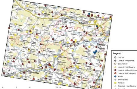
Figure 1. Example of the mining site distribution in the map sheet of the special map 1:75 000 Horšovský Týn 4150.
Table 2. Mining sites sorted by main used technologies. Note: “–” is the category of mining sites not classified in detail.
Pit Shelf No 6
quarry quarry data Stone quarry 1586 5043 84 6713 Gravel pit 35 10 20 65 Combined gravel pit+sand quarry 11 24 0 35 Sand quarry 226 1417 305 1948 Loam pit 47 232 321 600 Clay pit 31 126 71 228 Loam or clay pit (unspecified) 18 292 27 337 Combined loam pit+sand quarry 1 4 0 5 Kaolin pit 2 0 15 17 Unspecified raw material – – 10 10
manuscripts were used for localization and vectorization (Polák 1951a, b, 1956; Prokop, 1952; Kalášek, 1952). In three volumes, the maps were not preserved. In these cases the localization and consecutive vectorization of surface min-ing sites were carried out based on a written description only (Frejková, 1952; Vavˇrínová, 1951, 1952).
In all, 9958 objects have been vectorized. The standard de-viation of the vectorization accuracy is up to 150 m because of the inconsistent quality of graphic processing and preser-vation of map supplements of the Quarry Inventories.
For the purpose of spatial analyses, the vector layer in form of polygons was generated which should be instrumental for recording the area of particular districts and map sheets. The calculation of areas was done by means of the function “Cal-culate Geometry” (Fig. 3).
In order to enable the online visualization of generated data, the GIS project was appended with metadata (title, sum-mary, description, and tags); then the project with all vec-tor layers was saved by means of the function “Create Map Package” and uploaded to the mapping cloud platform Ar-cGIS Online. Herein a web map composition and lastly a fi-nal web map application in form of the hosted feature service the Quarry Inventories Online was created and configured.
4 Discusion and conclusions
146 R. Pokorný and M. T. Peterková: The abandoned surface mining sites in Czech Republic
Figure 2. Example of the mining site distribution in three districts (top: Semily; right: Nová Paka; bottom: Jiˇcín).
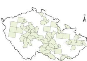
Figure 3. Areal extents of the districts and the map sheets processed in the published Quarry Inventories project volumes.
cultural heritage (Koutník, 2015), or the equally specialized application “Decorative Stones” (Dudíková Schulmannová and Skarková, 2010; Paleˇcek et al., 2014). Historical sites of opencast mining of raw materials in a wider European space are mapped by the project “Historic Quarries”, which covers – aside from several locations in the Czech
Repub-lic – mainly the territory of Slovakia, Poland, Hungary, Aus-tria, and Ukraine (Uhlir and Schaller, 2008–2010; Uhlir et al., 2013). Available online, in form of a database without map application, are the services “Italithos” (Giampaolo et al., 2000–2013) and the “Stone Quarries Database” (Russell, 2010), specialized mainly in raw materials mining in the era of the Roman Empire.
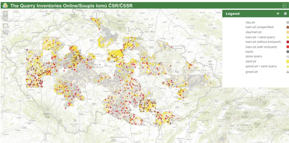
Figure 4. Screenshot of “the Quarry Inventories Online” web map application.
(40.9 %) was mapped, the real number of active quarries in the first half of the 20th century can be estimated at ca. 20 000–25 000. This corresponds to the average distributions of the quarries per each 3–4 km2(Peterková, 2015).
In time to come, therefore, a widening of the database is planned in several steps. First, data will be processed from similarly specialized manuscripts written after the publish-ing of the Quarry Inventories had been terminated (theses, paper card indexes, etc.). In areas where no inventory anal-yses have been done, air photos from the years 1937–1970 will be utilized (SINE, 2010).
The final and most time-consuming phase will be a field survey focused both on verification of existing entries and on completely new and still unmapped objects.
Data availability
The web map application Quarry Inventories Online is ac-cessible at http://mapserver.ujep.cz/seminarky/bp-peterkova/ (Fig. 4). GIS software users can display all layers as web map service sublayers (WMS) based on the client-server prin-ciple at http://195.113.140.12/arcgis/services/Projekty/ (Pe-terková, 2015).
Acknowledgements. The project was supported by a grant within the student grant competition at UJEP (Jan Evangelista Purkynˇe University) in Ústí nad Labem (no. 1/2014). Authors gratefully ac-knowledge the two last living authors of the “Quarry Inventories”, Jana Líbalová and Oldˇrich Holásek, for their constructive comments and discussions of the manuscript. Special thanks to the referees for their thoughtful and thorough reviews.
Edited by: L. Eppelbaum
References
Dudíková Schulmannová, B. and Skarková, H.: New internet database of decorative and building stones of the Czech Repub-lic, Czech Geological Survey, Prague, Geoscience Research Re-ports for 2009, 297–299, 2010 (in Czech, English abstract). Fajst, M. and Holásek, O.: The quarry inventories of the
Czechoslo-vak Socialist Republic. 55 – map sheet of the special map 1: 75 000 Náchod 3856, Central Geological Institute, Prague, 1961 (in Czech).
Fiala, F.: The quarry inventories of the Czechoslovak Republic. 4 – Banská Štiavnica district, Czech. Uni. Res. Test. Tech. Imp. Mat. Struct. and St. Geol. Sur. (in Czech: ˇCeskoslovenský svaz pro výzkum a zkoušení technicky d˚uležitých látek a konstrukcí spolu se Státním ústavem geologickým), Prague, 1934 (in Czech). Frejková, L.: The quarry inventories of the Czechoslovak Republic.
45 – map sheet Nový Jiˇcín 4160, Central Geological Institute, Prague, 1952 (in Czech).
Giampaolo, C., Adanti, B., and Di Pace, A.: Italithos. Roma Tre University, Roma, available at: http://www.italithos.uniroma3.it, last access: 10 December 2015, 2000–2013.
Gotthard, J.: The quarry inventories of the Czechoslovak Republic. 1 – Semily district, Czech. Uni. Res. Test. Tech. Imp. Mat. Struct. and St. Geol. Sur., Prague, 1932 (in Czech).
Hanisch, A. and Schmid, H.: Austrian Quarries, Verlag von Carl Graeser & Co, Wien, 1901 (in German).
148 R. Pokorný and M. T. Peterková: The abandoned surface mining sites in Czech Republic
Hejtman, B.: The quarry inventories of the Czechoslovak Republic. 25 – Písek district, Czech. Uni. Res. Test. Tech. Imp. Mat. Struct. and St. Geol. Sur., Prague, 1948a (in Czech).
Hejtman, B.: The quarry inventories of the Czechoslovak Republic. 26 – ˇCeský Brod district, Czech. Uni. Res. Test. Tech. Imp. Mat. Struct. and St. Geol. Sur., Prague, 1948b (in Czech).
Kalášek, J.: The quarry inventories of the Czechoslovak Repub-lic. 49 – map sheet Hodonín 4458, Central Geological Institute, Prague, 1952 (in Czech).
Kalášek, J. and Polák, A.: The quarry inventories of the Czechoslo-vak Republic. 41 – Moravské Budˇejovice district, Central Geo-logical Institute, Prague, 1950 (in Czech).
Katyk, M.: Building materials of the Czechoslovak Republic. Map sheet Piešˇtany 4559 – Slovakia, Stud. St. Geol. Inst., Bratislava, 19, 1–99, 1949 (in Slovak).
Katyk, M.: Building materials of the Czechoslovak Republic. Map sheet Senec 4759 – Slovakia, Stud. St. Geol. Inst., Bratislava, 21, 1–67, 1950a (in Slovak).
Katyk, M.: Building materials of the Czechoslovak Republic. Map sheet Trnava 4659 – Slovakia, Stud. St. Geol. Inst., Bratislava, 22, 1–71, 1950b (in Slovak).
Katyk, M.: Building materials of the Czechoslovak Republic. Map sheet Dunajská Streda 4859 and Klížska Nemá 4959 – Slovakia, Slov, Geot., 4, 1–39, 1951a (in Slovak).
Katyk, M.: Building materials of the Czechoslovak Republic. Map sheet Komárno 4860 and Iža 4960 – Slovakia, Slov, Geot., 5, 1– 28, 1951b (in Slovak).
Katyk, M.: Building materials of the Czechoslovak Republic. Map sheet Lanžhot 4558 – Slovakia, Slov, Geot., 1, 1–36, 1951c (in Slovak).
Katyk, M.: Building materials of the Czechoslovak Republic. Map sheet Malacky 4658 – Slovakia, Slov, Geot., 2, 1–47, 1951d (in Slovak).
Katyk, M.: Building materials of the Czechoslovak Republic. Map sheet Šurany 4658 – Slovakia, Slov, Geot., 3, 1–35, 1951e (in Slovak).
Koutník, P.: Stones, sandpits and limestone quarries in the Czech Republic, Faculty of Environment, J. E. Purkynˇe Uni-versity in Ústí nad Labem, Ústí nad Labem, Czech Re-public, available at: http://mapserver.ujep.cz/Projekty/Databaze_ dekorativniho_kamene/ (last access: 10 December 2015), 2015. Kratochvíl, J. and Zabloudil, J.: The quarry inventories of the
Czechoslovak Republic. 5 – Humpolec district, Czech. Uni. Res. Test. Tech. Imp. Mat. Struct. and St. Geol. Sur., Prague, 1934 (in Czech).
Líbalová, J.: The quarry inventories of the Czechoslovak Social-ist Republic. 52 – map sheet of the special map 1:75 000 Horšovský Týn 4150, Central Geological Institute, Prague, 1961a (in Czech).
Líbalová, J.: The quarry inventories of the Czechoslovak Social-ist Republic. 53 – map sheet of the special map 1:75 000 Karlovy Vary 3950, Central Geological Institute, Prague, 1961b (in Czech).
López-García, J. A., Oyarzun, R., López Andrés, S., and Manteca Martínez, J. I.: Scientific, Educational, and Environmental Con-siderations Regarding Mine Sites and Geoheritage: A Perspec-tive from SE Spain, Geoheritage, 3, 267–275, 2011.
Paleˇcek, M., Pospíšil, V., and Skarková, H.: Decora-tive stones. Czech Geologic Survey, Prague,
avail-able at: http://mapy.geology.cz/dekoracni_kameny/ and http://dekoracni-kameny.geology.cz, last access: 10 December 2015, 2014.
Pauk, F.: The quarry inventories of the Czechoslovak Republic. 21 – Chotˇeboˇr district, Czech. Uni. Res. Test. Tech. Imp. Mat. Struct. and St. Geol. Sur., Prague, 1947 (in Czech).
Pauk, F.: The quarry inventories of the Czechoslovak Republic. 24 – Nová Paka district (addendum), Czech. Uni. Res. Test. Tech. Imp. Mat. Struct. and St. Geol. Sur., Prague, 1948 (in Czech). Peterková, M. T.: Digitalization of the book series “Soupisy lom˚u
ˇ
CSR/ ˇCSSR”, BSc thesis, J. E. Purkynˇe University in Ústí nad Labem, 2015 (in Czech, English abstract).
Petersen, J.: The role of roadcuts, quarries, and other artificial ex-posures in geomorphology education, Geomorphology, 47, 289– 301, 2002.
Pokorný, M.: The quarry inventories of the Czechoslovak Republic. 20 – Holešov district, Czech. Uni. Res. Test. Tech. Imp. Mat. Struct. and St. Geol. Sur., Prague, 1947 (in Czech).
Pokorný, M.: The quarry inventories of the Czechoslovak Repub-lic. 34 – Opava district, Czech. Uni. Res. Test. Tech. Imp. Mat. Struct. and St. Geol. Sur., Prague, 1948 (in Czech).
Pokorný, M.: The quarry inventories of the Czechoslovak Republic. 40 – Olomouc district, Czech. Uni. Res. Test. Tech. Imp. Mat. Struct. and St. Geol. Sur., Prague, 1950 (in Czech).
Polák, A.: The quarry inventories of the Czechoslovak Republic. 17 – Tišnov district, Czech. Uni. Res. Test. Tech. Imp. Mat. Struct. and St. Geol. Sur., Prague, 1946a (in Czech).
Polák, A.: The quarry inventories of the Czechoslovak Republic. 18 – Nové Mˇesto na Moravˇe district, Czech. Uni. Res. Test. Tech. Imp. Mat. Struct. and St. Geol. Sur., Prague, 1946b (in Czech). Polák, A.: The quarry inventories of the Czechoslovak Republic. 19
– Velké Meziˇríˇcí district, Czech. Uni. Res. Test. Tech. Imp. Mat. Struct. and St. Geol. Sur., Prague, 1946c (in Czech).
Polák, A.: The quarry inventories of the Czechoslovak Republic. 28 – Jihlava district, Czech. Uni. Res. Test. Tech. Imp. Mat. Struct. and St. Geol. Sur., Prague, 1948a (in Czech).
Polák, A.: The quarry inventories of the Czechoslovak Republic. 30 – Znojmo district, Czech. Uni. Res. Test. Tech. Imp. Mat. Struct. and St. Geol. Sur., Prague, 1948b (in Czech).
Polák, A.: The quarry inventories of the Czechoslovak Republic. 35 – Daˇcice district, Czech. Uni. Res. Test. Tech. Imp. Mat. Struct. and St. Geol. Sur., Prague, 1949 (in Czech).
Polák, A.: The quarry inventories of the Czechoslovak Republic. 43 – map sheet Pardubice – Hradec Králové 3955, Central Geologi-cal Institute, Prague, 1951a (in Czech).
Polák, A.: The quarry inventories of the Czechoslovak Republic. 44 – map sheet of the special map Šumperk 4058, Central Geologi-cal Institute, Prague, 1951b (in Czech).
Polák, A.: The quarry inventories of the Czechoslovak Republic. 50 – map sheet Brno 4357, Central Geological Institute, Prague, 1956 (in Czech).
Procházka, V.: The quarry inventories of the Czechoslovak Repub-lic. 9 – Nˇemecký Brod district, Czech. Uni. Res. Test. Tech. Imp. Mat. Struct. and St. Geol. Sur., Prague, 1939 (in Czech). Prokop, F.: The quarry inventories of the Czechoslovak Republic.
Prokop, F.: The quarry inventories of the Czechoslovak Republic. 32 – Blatná district, Czech. Uni. Res. Test. Tech. Imp. Mat. Struct. and St. Geol. Sur., Prague, 1949a (in Czech).
Prokop, F.: The quarry inventories of the Czechoslovak Republic. 37 – Chrudim and Hlinsko district, Czech. Uni. Res. Test. Tech. Imp. Mat. Struct. and St. Geol. Sur., Prague, 1949b (in Czech). Prokop, F.: The quarry inventories of the Czechoslovak
Repub-lic. 48 – map sheet Javorník 3858, Central Geological Institute, Prague, 1952 (in Czech).
Prokop, F. and Vachtl, J.: The quarry inventories of the Czechoslo-vak Republic. 42 – Prague-city and Prague-countryside/north districts, Central Geological Institute, Prague, 1951 (in Czech). Purkynˇe, C.: Report on the activities of the State Geological
Insti-tute of the Czechoslovak Republic, Bull. St. Geol. Inst., 9, 1–24, 1933 (in Czech).
Raška, P., Balej, M., and Raška, M.: Differential evolution of rock-wall and talus cones in abandoned basalt quarries and its impli-cations for restoration management: case study from the Radobyl Hill, N Czech Republic, International Journal of Mining, Recla-mation and Environment, 25, 297–312, 2011.
Rost, R.: The Quarries of Bohemia and Moravia. 14 – Kralupy nad Vltavou district, Agency for Research on Soil in Bohemia and Moravia, Prague, 1942 (in Czech).
Russell, B. (database coordinator): Stone Quarries Database, in The Oxford Roman Economy Project. University of Oxford, Ox-ford, available at: http://oxrep.classics.ox.ac.uk/databases/stone_ quarries_database/, last access: 10 December 2015, 2010. SINE: Historical aerial images, CENIA and GEODIS Brno,
avail-able at: http://kontaminace.cenia.cz/, last access: 10 December 2015, 2010.
Šob, A.: The Quarry Inventories of the Czechoslovak Republic. 36 – Hodonín district, Czech. Uni. Res. Test. Tech. Imp. Mat. Struct. and St. Geol. Sur., Prague, 1950 (in Czech).
Soukup, J.: The Quarry Inventory. 10 – Jiˇcín district, Cz. Uni. f. Res. and Test. of Tech. Imp. Mat. and Struct. in coop. w. Geol. Inst. of Boh. and Mor. (in Czech: ˇCeský svaz pro výzkum a zkoušení technicky d˚uležitých látek a konstrukcí spolu s Geologickým ús-tavem pro ˇCechy a Moravu), Prague, 1940 (in Czech).
Tuˇcek, K.: The Quarry Inventory. 11 – Nová Paka district, Cz. Uni. f. Res. and Test. of Tech. Imp. Mat. and Struct. in coop. w. Geol. Inst. of Boh. and Mor., Prague, 1940 (in Czech).
Uhlir, C. and Schaller, K.: Historic Quarries. University of Salzburg, Salzburg, available at: http://www.historic-quarries.org/map, last access: 10 December 2015, 2008–2010.
Uhlir, C., Schaller, K., and Unterwurzacher, M.: Historic Quarries: Case Studies, in: Scientific Computing and Cultural Heritage: Contributions in Computational Humanities, edited by: Bock, H. G., Jäger, W., and Winckler, M. J., Springer-Verlag, Berlin, Heidelberg, 245–254, 2013.
Urban, K.: The quarry inventories of the Czechoslovak Republic. 7 – Louny district, Czech. Uni. Res. Test. Tech. Imp. Mat. Struct. and St. Geol. Sur., Prague, 1935 (in Czech).
Vachtl, J.: The quarry inventories of the Czechoslovak Republic. 2 – Sedlˇcany district, Czech. Uni. Res. Test. Tech. Imp. Mat. Struct. and St. Geol. Sur., Prague, 1933 (in Czech).
Vachtl, J.: The quarry inventories of the Czechoslovak Republic. 3 – Jílové district, Czech. Uni. Res. Test. Tech. Imp. Mat. Struct. and St. Geol. Sur., Prague, 1934a (in Czech).
Vachtl, J.: The quarry inventories of the Czechoslovak Republic. 6 – Benešov district, Czech. Uni. Res. Test. Tech. Imp. Mat. Struct. and St. Geol. Sur., Prague, 1934b (in Czech).
Vachtl, J.: The quarry inventories of the Czechoslovak Republic. 8 – Pˇríbram district, Czech. Uni. Res. Test. Tech. Imp. Mat. Struct. and St. Geol. Sur., Prague, 1935 (in Czech).
Vachtl, J.: The quarry inventories of the Czechoslovak Republic. 22 – Rakovník district, Czech. Uni. Res. Test. Tech. Imp. Mat. Struct. and St. Geol. Sur., Prague, 1947 (in Czech).
Vachtl, J.: The quarry inventories of the Czechoslovak Republic. 31 – Beroun district, Czech. Uni. Res. Test. Tech. Imp. Mat. Struct. and St. Geol. Sur., Prague, 1949a (in Czech).
Vachtl, J.: The quarry inventories of the Czechoslovak Republic. 39 – Prague-south district, Czech. Uni. Res. Test. Tech. Imp. Mat. Struct. and St. Geol. Sur., Prague, 1949b (in Czech).
Vavˇrínová, M.: The Quarries of Bohemia and Moravia. 12 – Žam-berk district, Geological Institute of Bohemia and Moravia, Prague, 1940 (in Czech).
Vavˇrínová, M.: The quarry inventories of the Czechoslovak Repub-lic. 16 – ˇRíˇcany district, Czech. Uni. Res. Test. Tech. Imp. Mat. Struct. and St. Geol. Sur., Prague, 1946 (in Czech).
Vavˇrínová, M.: The quarry inventories of the Czechoslovak Repub-lic. 27 – Tˇrebíˇc district, Czech. Uni. Res. Test. Tech. Imp. Mat. Struct. and St. Geol. Sur., Prague, 1948a (in Czech).
Vavˇrínová, M.: The quarry inventories of the Czechoslovak Repub-lic. 29 – Žamberk district (addendum), Czech. Uni. Res. Test. Tech. Imp. Mat. Struct. and St. Geol. Sur., Prague, 1948b (in Czech).
Vavˇrínová, M.: The quarry inventories of the Czechoslovak Repub-lic. 33 – Vysoké Mýto district, Czech. Uni. Res. Test. Tech. Imp. Mat. Struct. and St. Geol. Sur., Prague, 1949 (in Czech). Vavˇrínová, M.: The quarry inventories of the Czechoslovak
Repub-lic. 38 – Ledeˇc nad Sázavou district, Czech. Uni. Res. Test. Tech. Imp. Mat. Struct. and St. Geol. Sur., Prague, 1950 (in Czech). Vavˇrínová, M.: The quarry inventories of the Czechoslovak
Re-public. 46 – sheet Kralovice 4051, Central Geological Institute, Prague, 1951 (in Czech).
Vavˇrínová, M.: The quarry inventories of the Czechoslovak Repub-lic. 47 – map sheet ˇCeská Tˇrebová 4057, Central Geological In-stitute, Prague, 1952 (in Czech).
Vavˇrínová, M.: The quarry inventories of the Czechoslovak So-cialist Republic. 54 – map sheet of the special map 1:75 000 Chomutov 3851, Central Geological Institute, Prague, 1961 (in Czech).
Vavˇrínová, M., and Líbalová, J.: The quarry inventories of the Czechoslovak Republic. 51 – map sheet of the special map 1:75 000 Teplá 4050, Central Geological Institute, Prague, 1959 (in Czech).
Zorkovský, B.: Building materials of the Czechoslovak Republic. Map sheet Ružomberok 4362, Slovak Geotechnics, 6, 1–29, 1951 (in Slovak).