Volume 1, Issue 5, Pages 137-141, June 2017
© 2017 AJAST All rights reserved. www.ajast.net
Lane Detection using GPS-PPP and VISUAL Method
B.Shrivathsa
1and Jaishri Panjwani
21UG Student, Department of ECE, MVJ College of Engineering, Bangalore, India. Email: [email protected]
2Assistant Professor, Department of ECE, MVJ College of Engineering, Bangalore, India. Email: [email protected]
Article Received: 18 May 2017 Article Accepted: 04 June 2017 Article Published: 07 June 2017
1.INTRODUCTION
Lane detection is a process of locating the lane on which the motor vehicle is moving. With the rapid increase in the traffic, the traffic safety becomes more and more significant. The distraction and fatigue of the driver cause the vehicles to move out of their lanes which result in accidents. The intelligent Transport system, vehicles co-operate with the infrastructure to achieve a better and safer environment. Intelligence transport system works by measuring traffic, analyzing the reasons for control measures and applying the same. One of the methods required for traffic control is specific lane measurement and specific lane control. Therefore the car system requires both accurate position and width of the lane. Some of the methods used to detect lanes include LASER, range image, GPS, LIDAR, RADAR, with the aid of vision.
In paper [1]the position of the vehicle using differential GPS (D-GPS). The GPS-PPP techniques [2], does not need expensive equipment, hence it works in all weather and light conditions. In visual method [3], [4] the lanes are determined by markings on the surface of roads. Here many problems are observed such as parked and moving vehicles shadow of a tree, bad quality of lines, irregular lines, slope, writing, and marking. Several algorithms have been published on lane detection. The current article deals with GPS-PPP and visual method to provide better accuracy and robustly.
The structure of the paper is as follows, the first section includes various vehicle positioning techniques proposed by others, section II deals with monitoring of the position of vehicles, section III deals with GPS-PPP techniques. In the IV Section about the visual method and V sections about lane detection by both GPS-PPP and visual method.
2.MONITORING THE POSITION OF THE VEHICLE
Various sensors can be used to monitor the position of the vehicles. Here different types of sensors and techniques can be used to get the position of the vehicles. The GPS techniques are described first followed by vision techniques.
An overview of the GPS techniques is given in [5]. Mapping of the vehicle position to the road, an algorithm to map the position of the vehicle to the road have been developed. The usual problem in the GPS positioning techniques is that the accuracy of position is not within the lane-width. Hence it is impossible to do lane-mapping or the mapping the position of the vehicle to the lane. The accuracy decreases in the city or urban areas since there is no line of sight to a satellite under certain conditions or areas [6]. The problems of this technique can be solved by Differential GPS (D-GPS) [7], [8] which provides the more accurate position of the vehicle and help to improve lane determination. High-end dual-frequency GPS receiver in differential processing setup (carrier-waves) is used to create a specific lane map [9]. Here they discussed problems with driver errors and difficulties in finding the lane boundary demarcation. They also proposed another method that has geo-corrected aerial photography and manual lane finding to find a lane. But this method is expensive because it uses dual-frequency GPS receiver. It does not need any special types of equipment, manual lane finding, and dedicated mapping campaigns [2]. The performance of precise point positioning in real time demonstrated in [2] and for the static application. In [10], [11], a fusion of GPS and data from the video are used to increase location accuracy. The Vision method is one more method to find the accurate position of the vehicles using camera which detects the lane markings. A. B. Hillel, R. Lerner, D. Levi, and G. Raz have made a survey on recent progress in road and lane detection [12]. They have said that we can detect lanes and all lane markings. In all visual and video processing technique, a very good algorithm is needed to analyze image, video and detect lanes [13], [14]. These vision causes are not sufficient for finding the lane markings [15]. The dimensionality of the video is reduced by making appropriate transformations in order to speed up and detect the lane [16]. These techniques are also used to make autonomous vehicles. The method of finding lanes using visuals may depend on the quality of the video and type of the camera. In all these cases, the value of result can be changed by the bad weather and darkness. A B S T R A C T
A modern technique in transportation can achieve an improvement of traffic flow for a motor vehicle. Lane detection systems are useful in avoiding accidents and provide safety. Lane detection is a challenging task because of the variation in road condition while driving. With specific lane measurement and specific lane control, it is possible to increase the number of measurements. Lane can be determined with visual and global position system. The latest and affordable technique to achieve sub-meter accuracy in positioning is Single Precision Point Positioning (PPP). This paper presents a methodology to map the lanes using GPS Precise Point Positioning (GPS-PPP) and visual method. The GPS Precise point positioning trajectory data are collected by GPS-PPP equipped vehicle which drives a specific motorway. This is repeated for many times. Using trajectory data, the position of the vehicle along with the width of lanes are estimated. In the visual method, the lane is detected using Canny edge detector and Hough transformation. In this paper, we shall discuss lane determination using GPS precise point positioning and Visual method.
Volume 1, Issue 5, Pages 137-141, June 2017
© 2017 AJAST All rights reserved. www.ajast.net
The method to measure vehicle’s position down to the accuracy of the lane and create this map is lacking. This paper introduces this method with both visual and GPS-PPP, providing both the positioning techniques as well as the algorithm used.
3. SINGLE FREQUENCY GPS PRECISE POINT POSITIONING
The Global Position system has become a popular method for personal and vehicle navigation system. The normal GPS is sufficient for vehicle navigation system under most conditions. Moreover, the cost of the simple GPS receiver has been decreased over time. Several different positioning strategies are based on a method called Global Navigation Satellite System (GNSS). GPS positioning is the most basic positioning techniques. In GPS technique, pseudo-range measurement is used which requires at least four satellites. These four satellites are used to receive coordinates and its clock offset. The major errors of the GPS measurements are in the atmospheric disturbances and predicted trajectory which extends for several meters. The atmospheric disturbances are mainly seen in ionosphere and troposphere layers which lead to errors for several meters. A prior troposphere model can be used to reduce the delays in the troposphere which leads to high effect. Alternately, High-end dual-frequency receivers can be used to estimate the delays. Regional Satellite Based Augmentation System can improve accuracy by computing accurate satellite positions, clock offsets and modeling ionosphere delays. Nearby reference stations can be used to get much higher accuracy those in which accurate coordinates are available. Pseudo range measurement used in the D-GPS accuracy can reach centimeter or millimeter level. The disadvantages of differential positioning are:
(1) It needs large data transfer between users and reference station.
(2) It replies on the dense local or regional network of the reference station.
Due to all these reasons, it is unsuited for mass production applications. The GPS precise point positioning uses both pseudo-range measurement and carrier phase measurement [17]. It combines them with accurate satellite orbit and clock information, instead of measurement from nearby reference networks. Even by using these techniques, precise point positioning has many limitations:
1) Dual frequency measurements are needed to remove the ionosphere delay in measurements
2) Clock information and accurate satellite orbit information are initially available with significant delays.
Latest technologies have succeeded in overcoming most of the limitations by GPS-PPP. Now, accurate satellite orbit in real-time is available together with real-time satellite clock estimations, which are helpful to overcome these limitations [18], [19]. As mentioned above the ionosphere delay is one of the limitations for receiving a signal from the satellite. One method of reducing this limitation is known as GRAPHIC (Group and Phase Ionosphere Correction) [20]. It can be used to average the pseudo-range and carrier phase measurements for every satellite. The average of the signals are taken to remove the first order ionosphere delay that has the same magnitude but opposite sign on pseudo- range and carrier phase measurement. This will reduce the pseudo-range
measurement to half in single frequency receiver, but this makes the above limitation worse [21]. In order to improve accuracy and eliminate the limitation in the GRAPHIC method, single frequency PPP algorithm has been developed by the Delft University of Technology which uses ionosphere maps instead of calculating the ionosphere delay. This method is much faster than Dual-frequency PPP and GRAPHIC method [22]. This method can be used over cheap GPS receiver in order to provide high accurate positioning of the vehicle. Due to this, it can be used in many applications including Lane Detection. The GPS- PPP can be used in many places such as, seafloor mapping, land surveying [23], precision farming, navigation, surveying and mapping, aviation, shipping and railway transportation, security applications etc.
Fig.1. The test performed on 5km length of the A13 motorway between Delft and Rotterdam
Fig.2. The u-box TIM Lp single frequency receiver evaluation kit (left) and Tri-Big Brother patch antenna
Volume 1, Issue 5, Pages 137-141, June 2017
© 2017 AJAST All rights reserved. www.ajast.net
Rondenrijis) as in figure 1. For this road, the position of the lane is calculated by using the file recorded by the Dutch Road Authority (DTF). The algorithm is, GPS-PPP trajectory data are collected, the position of the data is then mapped to the road.
Fig.3. The GPS-PPP equipment mounted on the vehicle
4. VISION BASED LANE DETECTION
One more method to determine the lane is the vision-based approach. The vision-based approach uses the camera on the vehicle to sense and recognize the lane marking, road curvature, and road environment. The vision-based approach is divided into two tasks:
1) Lane detection and 2) Lane tracking
Lane tracking is easier than lane detection. Lane detection is the problem of locating lane boundaries without knowledge about road geometry. The general method of detecting the lane is to take an image of the road with help of camera attached to the motor vehicle. The image which is taken from the camera is then processed by converting the given image into grayscale image. Noise will be present in the image. This noise will cause an error in detecting the edge of the lane. Therefore filtering techniques are used to remove noise in the images. Some of the common filtering methods are a bilateral filter, Gabor filter, and trilateral filter. With canny filter and edge detector, edge images are obtained. The obtained edge images are then sent to the line detector which produces a left and right lane boundary segments. The lane boundary uses Hough Transformation which scans and returns a series of points on the left and right side of the image. The detection speed can be increased by converting the original image into gray scaling. F. Mariut, C. Fosalau and D. Petrisor proposed a simple algorithm to detect the lane marks, lane marks characteristics and also determine the traveling direction. The potential lines in the images are detected by the Hough transform. The Hough transform is a feature extraction technique which is used in image analysis, computer vision, and digital image processing in order to identify the lines in the image. The extended Hough transform is used to identify the positions of arbitrary shapes. There are some limitations of the Visual based approach. They are
1) Computation is complex for objects with many parameters.
2) Looks for only one single type of object.
3) The length and the position of a line segment cannot be determined.
Fig.4. Gray converting (a) and filtering (b)
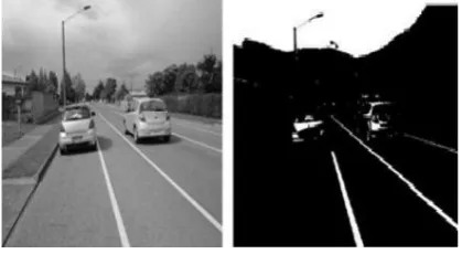
Fig. 5. Colouring the image
Fig.6. Various challenges in lane detection. [a] A vehicle occluding nearby lane [b] Presence of shadow [c] Rainy road [d] Extreme illumination on left side of image
5.LANE DETECTION USING GPS-PPP AND VISUAL METHOD
GPS and Visual method have their own limitations like GPS require dual frequency receiver and ionosphere delay while in the visual method, it is very complex to detect and track the lane. In this paper, both GPS-PPP and visual method is used to get the more accurate position of the vehicle. The algorithm of this is given below. Flow chart is divided into four parts, 1) Lane detection using GPS-PPP.
2) Lane detection using visual approach
Volume 1, Issue 5, Pages 137-141, June 2017
© 2017 AJAST All rights reserved. www.ajast.net
First, the GPS-PPP signals are detected by using a signal receiver, which is used to find the road where the vehicle is positioned. The obtained GPS-PPP is mapped to already available tracks. In the visual method, the image obtained from the camera is blurred or filtered. Then it is converted into a gray image. The top of the image is removed to speed up the process. Canny edge detector is used to detect the edges and Hough Transformation to determine the Lane. Lane is colored using image processing technique. The output of both first and second part is combined and compared to get more accurate and precise value.
This value is used to track the vehicle. This process is repeated continuously to check whether the motor vehicle is in the lane or not. If the vehicle departs or changed its lane, the system will give a warning.
Fig. 7. Flowchart
6. CONCLUSION
The lane detection techniques play a significant role in Intelligent Transport system. The use of lane detection
techniques is whenever the specific vehicle goes out of the lane, the system detects it and warns the vehicle driver. This will help in prevent road accidents. It also used in self-driving cars, in order to drive the car. In this paper, lane detection using GPS-PPP and visual methods have been studied. The GPS precise point positioning is accurate to track the vehicle down to lane, but it requires a road map with individual lanes. Whereas, the visual method uses Hough transformation in order to recognize the lane. Therefore, both visual and GPS-PPP methods are used to overcome the limitation of the above-proposed method. Still, these methods won't be 100% accurate. In near future, one can modify the existing Hough transformation and GPS-PPP method, so it can measure in any environmental conditions like sunny days, foggy days, rainy days etc.
REFERENCES
[1] A. Chen, A. Ramanandan, and J. A. Farrell, ―High-precision lane-level road map building for vehicle navigation,‖ in Proc. IEEE/ION Position Location Navigator. Symp. (PLANS), Apr. 2010, pp. 1035–1042.
[2] Victor L. Knoop, Peter F. de Bakker, Christian C. J. M. Tiberius, and Bart van Arem "Lane Determination with GPS Precise Point Positioning", IEEE Intell. Transp. pp. 2017 1524-9050
[3] Y.-W. Seo, C. Urmson, and D. Wettergreen, ―Ortho-image analysis for producing lane-level highway maps,‖ in Proc. 20th Int. Conf. Adv. Geogr. Inf. Syst., 2012, pp. 506–509.
[4] A. Joshi and M. R. James, ―Generation of accurate lane-level maps from coarse prior maps and Lidar,‖ IEEE Intell. Transp. Syst. Mag., vol. 7, no. 1, pp. 19–29, Jan. 2015.
[5] I. Skog and P. Handel, ―In-car positioning and navigation technologies—A survey,‖ IEEE Trans. Intell. Transp. Syst., vol. 10, no. 1, pp. 4–21, Mar. 2009.
[6] Y. Cui and S. S. Ge, ―Autonomous vehicle positioning with GPS in urban canyon environments,‖ IEEE Trans. Robot. Autom., vol. 19, no. 1, pp. 15–25, Feb. 2003.
[7] J. Farrell and T. Givargis, ―Differential GPS reference station algorithm design and analysis,‖ IEEE Trans. Control Syst. Technol., vol. 8, no. 3, pp. 519–531, May 2000.
[8] J. Du and M. Barth, ―Bayesian probabilistic vehicle lane matching for link-level in-vehicle navigation,‖ in Proc. IEEE Intell. Vehicles Symp., Jun. 2006, pp. 522–527.
[9] W. Wang, H. Chen, and M. C. Bell, ―Vehicle breakdown duration modeling,‖ J. Transp. Statist., vol. 8, no. 1, pp. 75–84, 2005.
[10] M. A. Sotelo, F. J. Rodriguez, and L. Magdalena, ―VIRTUOUS: Vision-based road transportation forunmanned operation on urban-like scenarios,‖ IEEE
Trans. Intell. Transp. Syst., vol. 5, no. 2, pp. 69–83, Jun.
2004.
Volume 1, Issue 5, Pages 137-141, June 2017
© 2017 AJAST All rights reserved. www.ajast.net
lane markings,‖ in Proc. IEEE/RSJ Int. Conf. Intell. Robots Syst. (IROS), Oct. 2015, pp. 3119–3124.
[12] A. B. Hillel, R. Lerner, D. Levi, and G. Raz, ―Recent progress in road and lane detection: A survey,‖ Mach. Vis. Appl., vol. 25, no. 3, pp. 727–745, 2014.
[13] Y. U. Yim and S.-Y. Oh, ―Three-feature based automatic lane detection algorithm (TFALDA) for autonomous driving,‖ IEEE Trans. Intell. Transp. Syst., vol. 4, no. 4, pp. 219–225, Dec. 2003.
[14] J. McCall and M. M. Trivedi, ―Video-based lane estimation and tracking for driver assistance: Survey, system, and evaluation,‖ IEEE Trans. Intell. Transp. Syst., vol. 7, no. 1, pp. 20–37, Mar. 2006.
[15] Z. Kim, ―Robust lane detection and tracking in challenging scenarios,‖ IEEE Trans. Intell. Transp. Syst., vol. 9, no. 1, pp. 16–26, Mar. 2008.
[16] Q. Li, N. Zheng, and H. Cheng, ―Springrobot: A prototype autonomous vehicle and its algorithms for lane detection,‖ IEEE Trans. Intell. Transp. Syst., vol. 5, no. 4, pp. 300–308, Dec. 2004.
[17] J. F. Zumberge, M. B. Heflin, D. C. Jefferson, M. M. Watkins, and F. H. Webb, ―Precise point positioning for the efficient and robust analysis of GPS data from large networks,‖ J. Geophys. Res., vol. 102, no. B3, pp. 5005–5017, 1997.
[18] R. J. P. van Bree, C. C. J. M. Tiberius, and A. Hauschild, ―Real time satellite clocks in single frequency precise point positioning,‖ in Proc.22nd Int. Tech. Meeting Satellite Division Inst. Navigat. (ION GNSS), v Savannah, GA, USA, Sep. 2009, pp. 2400–2414.
[19] S. Loyer, F. Perosanz, F. Mercier, H. Capdeville, and J.-C. Marty, ―Zero-difference GPS ambiguity resolution at CNES–CLS IGS analysis center,‖ J. Geodesy, vol. 86, no. 11, pp. 991–1003, 2012.
[20] T. Yunck, Global Positioning Systems: Theory and Applications. Progress in Astronautics and Aeronautics (Orbit Determination), vol. 163. Washington, DC, USA: AIAA, 1996.
[21] Y. Chen et al., ―Lane detection based on a visual-aided multiple sensors platform,‖ in Proc. IEEE/ION Position Location Navigat. Symp. (PLANS), Apr. 2012, pp. 740–747.
[22] R. van Bree and C. Tiberius, ―Real-time single-frequency precise point positioning: Accuracy assessment,‖ in GPS Solutions, vol. 16. Berlin, Germany: Springer-Verlag, 2012, pp. 259–266.
[23] S. Bisnath and Y. Gao, ―Current state of precise point positioning and future prospects and limitations,‖ in Observing Our Changing Earth. Berlin, Germany: Springer, 2009, pp. 615–623.
[24] F. Mariut, C. Fosalau and D. Petrisor, ―Lane Mark Detection Using Hough Transform", In IEEE International