www.nat-hazards-earth-syst-sci.net/6/779/2006/ © Author(s) 2006. This work is licensed under a Creative Commons License.
and Earth
System Sciences
Development of a methodology to assess man-made risks in
Germany
D. Borst1,2, D. Jung1,2, S. M. Murshed1,2, and U. Werner1,2
1University of Karlsruhe (TH), Institute for Finance, Banking and Insurance, 76128 Karlsruhe, Germany 2Center for Disaster Management and Risk Reduction Technology (CEDIM), 76128 Karlsruhe, Germany
Received: 27 April 2006 – Revised: 11 July 2006 – Accepted: 11 September 2006 – Published: 22 September 2006
Abstract. Risk is a concept used to describe future poten-tial outcomes of certain actions or events. Within the project “CEDIM – Risk Map Germany – Man-made Hazards” it is intended to develop methods for assessing and mapping the risk due to different human-induced hazards. This is a task that has not been successfully performed for Germany so far. Concepts of catastrophe modelling are employed including the spatial modelling of hazard, the compilation of different kinds of exposed elements, the estimation of their vulnera-bility and the direct loss potential in terms of human life and health.
The paper is divided in two sections: First, an ana-lytic framework for assessing the broad spectrum of human-induced risks is introduced. This approach is then applied for three important types of human-induced hazards that are representative for a whole class of hazards: Accidents due to nuclear power plants (NPP) or air traffic, and terrorism.
For the analysis of accidents, risk is measured with respect to getting injured or dying when living in certain buffer zones around hazard locations. NPP hazard expert knowledge is used and supplemented with observations on aging effects leading to a proprietary index value for the risk. Air traf-fic risk is modelled as an area related phenomenon based on available accident statistics leading to an expected value of risk.
Terrorism risk is assessed by the attraction certain ele-ments (like embassies in the case of conventional threats) dis-play in the eye of potential aggressors. For non-conventional targets like football games, a detailed approach measuring their susceptibility to different kinds of attacks within prede-fined scenarios was developed; this also allows a ranking of attack modes.
Correspondence to: D. Borst ([email protected])
1 State of the art of mapping man-made risks in Ger-many
The objective of the paper is to develop a methodology for as-sessing major man-made risks in Germany based on a spatial analysis of their impacts on people and physical assets. Such an approach is needed for mapping this type of risk alongside with risks related to natural hazards. A map server solution, the “Risk Explorer” (cf. M¨uller et al., 2006), will show both natural and human-induced hazards, exposures, vulnerabili-ties, and risks within one viewer system. This is a crucial first step towards the integrated assessment of a multitude of hazards. Such maps are fundamental to risk mitigation and risk management planning at the individual, company, and societal level – but up to date no comprehensive risk maps are publicly available for the whole of Germany.1
In 2004, Bundesamt f¨ur Bev¨olkerungsschutz und Katas-trophenhilfe (BBK, Federal Office for Civil Protection and Disaster Response) started a project to collect information about the main hazards in each state in order to derive a “Harmonized Hazard Assessment” for Germany. Not all of the federal states are complied, and the incoming re-ports differed in quantity and detail. The risk analysis of Hessen is considered exemplary and can be accessed via the internet (http://www.nassauischer-feuerwehrverband.de/ Downloads/KatSGefaehrdungsanalyse.pdf [17/07/2006]). It provides some statistics and qualitative descriptions of nat-ural hazards, technological accidents, malicious actions of persons, hysteric behaviour at mass events, and war. It also gives a first idea about the mitigation capacity available to manage these risks. However, none of the hazards mentioned is mapped or assessed in conjunction with others.
1The hazard maps of insurance companies cover a wide range of
780 D. Borst et al.: A methodology to assess man-made risks in Germany Another approach considered as a pilot study for
country-wide risk mapping is the Schutzdatenatlas (Protection Data Atlas: http://www.kfs.uni-kiel.de/∼sda/ [17/07/2006]) de-veloped at the Disaster Research Center of the Christian-Albrechts University of Kiel. This GIS-based platform has been serving as a research tool for the development of meth-ods dedicated to vulnerability analyses. As a starting point, it relies on object data of a county (Ditmarschen) in Northern Germany.
BBK developed DeNIS II – a geo-referenced informa-tion system for mapping hazardous objects and events in Germany as well as weather conditions and mitigation re-sources. It can also integrate remote sensing data and is available both for the federal and the state level and for non-governmental relief organizations. The general public, how-ever, has to rely on the web-site (http://www.denis.bund.de [17/07/2006]) which provides links to articles and other kind of information from various, mostly scientific, sources. Top-ics listed range from natural disasters to chemical and nuclear accidents, traffic accidents, terrorism, fire, and explosions. The user is expected to integrate the information provided and to assess his/her risk. The problems resulting from the approach employed for the public website are evident: No-body – neither layperson nor expert – is able to make up a comprehensive ad hoc-assessment of the risks related to a specific geographic area.
To sum up, there are several lacunae to be filled regard-ing the mappregard-ing of man-made risks in Germany: First of all, more data has to be collected for a harmonized and country-wide hazard assessment as intended by the BBK. Second, this data needs to be collected and analyzed following a stan-dardized approach in order to assure its comparability across various kinds of hazards, exposure, and vulnerability. Pub-lic security permitting the information then has to be made available to the public in an intelligible way.
Maps are good instruments for integrating complex geography-related and other data, but there are hardly any approaches for mapping man-made risks on German terri-tory. One exception is the European Union (EU) wide re-search program ESPON2where partners from various Euro-pean countries have been conducting research on natural and technological hazards. However, due to the focus on spa-tial planning responses, a thorough filtering of the research objects was done which reduced the technological hazards considered to a relatively small number including major ac-cident hazards of Nuclear Power Plants (NPP) and chemical plants, air traffic as well as oil processing, transport and stor-age. “Social hazards” (following the terminology of EEA, 2003:VI) like terrorism or war have not been investigated in detail.3 Despite limited access to data on technological
2European Spatial Planning Observation Network (ESPON):
http://www.espon.eu [17/03/2006], cf. Schmidt-Thom´e (2006).
3Risk consulting companies like Risk Management Solution
(RMS) or EQECAT, on the other hand, do offer integrated
anal-hazards (Schmidt-Thom´e, 2006:65f.), the international con-sortium was able to construct preliminary synthetical maps regarding hazard, vulnerability, and risk for the EU 27+2.
We chose to develop our approach based on a generic catastrophe model as used in geographic information sys-tems. It is laid out in Sect. 2. To facilitate a comprehensive assessment of man-made risks and their mapping by means of more standardized data, a detailed typology of man-made risks is presented, too. Additionally, we highlight some gen-eral problems in assessing these risks and briefly state the reasons for selecting certain hazards for a detailed consider-ation within this paper. Section 3 provides an overview of the general methodological approach used for data analysis and visualisation of risks in maps. Section 4 explains in detail our work done for assessing and mapping these risks. Ac-cording to the project context, only direct loss potentials are assessed for drawing the risk map; at the same time, consid-erations about individual or societal risk perception have to be disregarded. Section 5 finally provides a short summary and gives an outlook of future research necessities and pos-sibilities. Our analytic framework for risk specific analyses and the mapping of selected man-made risks might serve as a starting point for integrated risk research in this area.
2 Concept of risk
2.1 Quantitative approach for assessing and mapping man-made risks
There is a multitude of risk concepts and a large variety of taxonomies defining aspects like hazard, exposure or vulner-ability. Renn (2005:114–138) gives an exhaustive overview of the risk terminology currently used in scientific and en-gineering literature or in documents published by interna-tional organizations like the United Nations Internainterna-tional Strategy for Disaster Reduction (UN/ISDR). Additionally (multi)national approaches prepared by political or technical government advisory bodies and standard setting committees are presented.
For our purposes the terminology suggested by the UN/ISDR (2004) is adequate. Even though this approach has been developed for investigating the impact of natural forces on humans and their socio-economic or environmen-tal context, it can be adapted to the modelling of other kinds of hazards and their effects. In the report risk is defined as “the probability of harmful consequences, or expected losses (deaths, injuries, property, livelihoods, economic activity dis-rupted or environment damaged) resulting from interactions between natural or human-induced hazards and vulnerable conditions” (UN/ISDR, 2004:3).
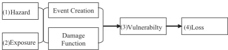
Among natural scientists, engineers, and economists, risk is modelled as the function of an interaction between four basic components: (1) certain hazards, (2) elements exposed to hazardous events with specified characteristics, (3) the susceptibility of the exposed elements to the hazardous im-pact, and (4) the resulting consequences (see, e.g., Mech-ler, 2004:16–20; Sinha and Goyal, 2004:107; UN/ISDR, 2004:6). Catastrophe models4 have a similar structure (cf. Fig. 1).
In the hazard module extreme natural events such as hur-ricanes or human-induced events due to terrorism are de-scribed regarding cause-effect relationships. In the case of human-induced events data is quite scarce, and the informa-tion available might not be representative for other events to come (Kunreuther et al., 2005:218). Additionally, human ac-tions can be directed to produce damages of a certain extent (such as sabotage, terrorism, and war), or they may uninten-tionally result in damages (like accidents and gradual envi-ronmental degradation). For estimating the frequency, sever-ity and locations of future actions of malicious intent, input from experts on threat assessment is needed (Kunreuther et al., 2005:220). The modelling of accidents involves other specific problems: In general, it is very difficult to obtain hazard data, and the data collection process is not standard-ized, with missing data on small-scale events.
The exposure module contains geographic data on the lo-cation of the elements at risk (address, postal code, etc.) as well as information on typical characteristics of the exposed objects and subjects. This includes, e.g., the construction type of buildings, or data regarding the average daytime pop-ulation and the maximum capacity of schools, shopping cen-tres or stadiums (Balmforth et al., 2005).
The creation of synthetic events is possible via probabilis-tic models and computer simulation or by the determinis-tic approach of scenario planning. In conjunction with the hazard module, both approaches are able to differentiate be-tween various qualities of events (is it an industrial accident or vicious sabotage?), related intensities (e.g., in terms of pressure waves of bomb blast) and estimated frequency.
Damage functions are a quantitative estimate of the impact produced by a hazard phenomenon on the elements at risk. Damage functions are region specific and reflect a thorough and detailed understanding of the local conditions and prac-tices (Clark, 2002:185). These are “determined by physical, social, economic, and environmental factors or processes, which increase the susceptibility of a community to the im-pact of hazards” (UN/ISDR, 2004, vol. II:3), and thus its vul-nerability. Location, and its mapping, is an essential
compo-4FEMA (http://www.fema.gov/plan/prevent/hazus/) offers an
open-source multi-hazard catastrophe model (HAZUS-MH MRl); proprietary modelling software and services have been devel-oped by AIR Worldwide (http://www.air-worldwide.com/), EQE-CAT (http://www.eqecat.com/), and RMS (http://www.rms.com/) [all 17/07/2006].
Vulnerabilty Loss
Hazard
Exposure
Event Creation
Damage Function
(1)
(2)
(3) (4)
Fig. 1. Structure of risk and catastrophe models (adapted from
Grossi et al., 2005:261).
1There, components (1)–(4) are represented and “exposure” is
called “inventory”. We prefer to retain the former term as it is used both in risk concepts and catastrophe models.
nent of vulnerability assessment. It helps to explain what makes people and places where they live, work and play vul-nerable to natural, technological, and purposeful threats like terrorism (Abler and Richardson, 2003:123–126).
The definition of risk by UN/ISDR (2004) refers to direct and indirect, economic and human losses including latent (environmental) conditions that may represent future threats. Not all of these can be modelled for mapping. The following section, therefore, introduces a screening approach that ex-plains our selection of human-induced risks based on hazard characteristics, exposure, vulnerability, damage and losses. Instead of the concept of losses, we mainly use a concept of damage which is more general: Losses only contain the economic evaluation of damage of any kind. However, this economic aspect is not covered in this paper. We focus on potential harm to people which is traceable in its immedi-ate, short-term effects. These damages to life and health can, therefore, be categorized as potential direct damages. They are assessed in terms of their physical outcome, without a translation into monetary values.
2.2 Selecting man-made hazards for detailed analysis In its summary account on Germany’s hazard potential, BBK5(BVA, 2003:15) states that a special focus is needed regarding major nuclear, chemical and biological accidents, large-scale fires, heavy weather-related events like flood-ings and storms or earthquakes, and events affecting a very high number of people. These include military conflicts, terrorism, sabotage, organized crime, major accidents and havaries, extreme natural events and epidemics. This account mirrors experiences of past events, assessments of damage potential, and expectations regarding the risk mitigation ca-pacity in Germany.
Not all of the hazards listed above show distinctive spa-tial features that allow a modelling by the mapping approach
5To be consistent throughout the article, we use the current
782 D. Borst et al.: A methodology to assess man-made risks in Germany intended here6. Potentially ubiquitous and very dynamic
hazards such as military conflicts or health risks due to epi-demics have to be represented differently for further insights. This also relates to health hazards stemming from the former use of asbestos in construction projects all over Germany, or from fires of the built environment. That kind of hazard is static but scattered over the whole country which makes it hard to point out important localizations of potential dam-ages.
Frequent events resulting in damages that are unlikely to exceed the mitigation capacity of individuals, communities or regional authorities are also not considered. This refers, e.g., to traffic accidents on roads involving human casual-ties.7 It has to be acknowledged, however, that the trans-portation of hazardous materials can have disastrous conse-quences and may affect larger areas in Germany. But again it is ubiquitous, not publicly documented and, therefore, dif-ficult to map.
There are other reasons for neglecting minor events when doing research on human-induced hazards: Small incidents in complex systems like industrial plants elude an external observation by non-technical experts. These are hardly doc-umented, and the information regarding small incidents is not published.
To sum up, data availability, coping capacity, cause-effect observations and mapping-related demands serve as exclu-sion criteria for certain hazards. They also guide the selec-tion process for hazards to be modelled for mapping.
Air traffic accidents have the potential of hurting a large number of people at the same time, thus imposing high de-mands on rescuing efforts and other risk management mea-sures in case of secondary effects. Industrial facilities as well, namely NPP, are potential sources of major hazardous events. Also mass gatherings at sports or arts events, at fairs, shopping centres or large office buildings, etc. may be af-fected by problems of varied origin. Since a comprehen-sive assessment of all mass rallies in Germany seems to be an insolvable task, we decided to consider disasters at foot-ball games as a pilot example. This also serves as prepara-tory work for the field of malicious attacks. Another pilot study deals with terrorist attacks on attractive targets like em-bassies.
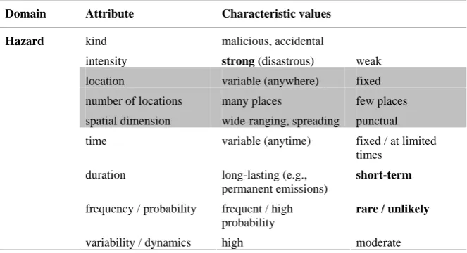
2.3 Hazard characteristics of man-made risks
Both the criteria used for selecting certain man-made risks and aspects of particular relevance for risk mapping serve as a starting point for the typology to be developed. In the
fol-6For another spatial filtering compare the ESPON 1.3.1-project
as described in Schmidt-Thom´e (2006:15).
7For assessing (and managing) societal vulnerability the
fre-quent events of road traffic accidents, occupational accidents and traditional, everyday crime are normally excluded (Hovden, 2004:631). Societies have developed coping schemes for these risks that are accepted to a certain extent (Starr, 1969).
lowing, accidents resulting from technical, human or organ-isational failures are differentiated from events of deliberate origin.
Accidents displace a normal flow of events. Failures orig-inally happening independently of each other may coincide in their effects, conglomerate, and reinforce or attenuate each other, which makes their analysis quite complex.
Regarding industrial accidents, hazard identification meth-ods based on Failure Modes and Effects Analyses, Hazard and Operations Analysis8may help to provide an extensive overview of what can go wrong and how likely this might be, but as long as human actions are integrated with technol-ogy surprises are possible. For achieving a comprehensive modelling of accidental man-made hazards, it is, therefore, necessary to complement the understanding of processes by other means (cf. Sect. 4).
This is also essential for the assessment of malicious ac-tions. As an outcome of continuously evolving motivations to attack they cannot be fully explained by either observ-able events or analyses of structural vulnerabilities. Mali-cious actions arise out of deliberate preparations of people who are informed about the history of past attacks while tak-ing into account possible countermeasures to fend them off. This generates a dynamic uncertainty in time regarding all deliberate malicious actions, and an interdependent vulnera-bility between potential targets of terrorism. The targets who prepare for threats are less likely to be attacked because of heightened costs for the aggressors (Michel-Kerjan, 2003). Consequently, this raises the probability of attacks on other targets. But as long as potential targets are interrelated (e.g., by business connections or physical links like supply-chains) the threat remains high even for the partners that do not have to experience any direct attacks (Kunreuther and Heal, 2003). Regarding the mapping of risk, it is important to distin-guish the location and spatial dimensions of perils as well as the number of possible sources of unwanted events. As-pects with this particular relevance are highlighted by the grey background colour in Table 1.
There are fixed locations as for accidents at industrial plants or variable ones as in the case of air traffic accidents that can literally occur anywhere. The boundaries with re-spect to spatial dimensions may be marked by the location of a hazard itself (accident in a football arena), but others like hazardous releases from chemical plants may spread past the zoning of the source. The number of possible locations of a certain type of hazard ranges from only a few as in the case of nuclear power plants in Germany to an unmanageably high number of, e.g., chemical, facilities using or producing haz-ardous materials.
Concerning temporal aspects of hazards, the time of occur-rence can either be restricted – for example to the schedule of mass rally events – or be variable as for accidents at industrial
8A short overview of various approaches in quantitative risk
D. Borst et al.: A methodology to assess man-made risks in Germany 783
Table 1. Hazard characteristics of man-made risks (grey background and bold fonts imply aspects of particular relevance for risk mapping and criteria used for selecting certain man-made risks, respectively).
understanding of processes by other means (cf. chapter 4).
This is also essential for the assessment of malicious actions. As an outcome of continuously
evolving motivations to attack they cannot be fully explained by either observable events or
analyses of structural vulnerabilities. Malicious actions arise out of deliberate preparations of
people who are informed about the history of past attacks while taking into account possible
countermeasures to fend them off. This generates a dynamic uncertainty in time regarding all
deliberate malicious actions, and an interdependent vulnerability between potential targets of
terrorism. The targets who prepare for threats are less likely to be attacked because of
heightened costs for the aggressors (Michel-Kerjan, 2003). Consequently, this raises the
probability of attacks on other targets. But as long as potential targets are interrelated (e.g., by
business connections or physical links like supply-chains) the threat remains high even for the
partners that do not have to experience any direct attacks (Kunreuther and Heal, 2003).
Regarding the mapping of risk, it is important to distinguish the location and spatial
dimen-sions of perils as well as the number of possible sources of unwanted events. Aspects with
this particular relevance are highlighted by the grey background colour in Table 1.
Table 1. Hazard characteristics of man-made risks (grey background and bold fonts imply aspects of particular relevance for risk mapping and criteria used for selecting certain
man-made risks, respectively)
Domain Attribute Characteristic values
kind malicious, accidental
intensity strong (disastrous) weak
location variable (anywhere) fixed
number of locations many places few places
spatial dimension wide-ranging, spreading punctual
time variable (anytime) fixed / at limited
times
duration long-lasting (e.g.,
permanent emissions)
short-term
frequency / probability frequent / high
probability
rare / unlikely Hazard
variability / dynamics high moderate
9
plants that may happen any time. The duration of a hazard may range from short-term (for most of man-made risks) to long-lasting as in continuous emission of small amounts of radiation to the environment by a nuclear power plant.
A fact of great influence on risk assessment is the fre-quency of a hazard ranging from very rare to rather frequent events with low to high probability, respectively. Whereas a maximum credible nuclear accident can be considered un-likely on German territory, cases of fire are happening quite frequently, therefore displaying a high probability. At the same time, they can be managed to a large extent with the existing resources provided.
One aspect that marks a clear distinction between acci-dental risks and risks of malicious nature is the dynamics of hazards. Most man-made perils change moderately over time as a result of technological and other developments – the use of larger aircrafts and the global increase of travellers result in a shift of the hazard in the domain of air traffic accidents. Terrorism, however, can alter almost immediately, e.g., by changes in the doctrines of the assaulters regarding the usage of weapons of mass destruction. The dynamics of terrorism risk is, therefore, immensely high.
As explained before (and highlighted in Table 1 in bold), we have chosen to concentrate our efforts on hazards of dis-astrous intensity. Realizations thereof are rare, and especially the short-term consequences ask for coordinated prepara-tions to manage the risk. Our contribution consists in the mapping of the selected hazards.
2.4 Exposure, vulnerability and damages in the domain of man-made risks
Special characteristics of human-induced risks are not re-stricted to the hazard domain; they also extend to aspects
of exposure, vulnerability and damages. These are listed in Table 2 and, once again, aspects with a special relevance for mapping are highlighted in grey.
Regarding exposure, a basic distinction is given by the different kinds of elements at risk which comprehend hu-mans, the environment, physical assets like buildings, pro-duction processes and cultural values. Traffic accidents and mass rally events tend to primarily generate human casual-ties whereas industrial accidents have the potential to addi-tionally harm assets, production processes and the environ-ment. In the case of terrorism, cultural values form an im-portant part of exposure. As the undermining of society by the means of attacking its fundamental values forms one part of the bundle of aims of the assaulters (OECD, 2003:104; Laqueur, 2003), they accordingly choose their targets.
Due to differences in spatial dimensions, the granularity of risk-prone areas varies. At least two cases can be distin-guished:
– man-made risks with the potential of affecting extended geographical areas, like accidents in NPP,
– events happening on a limited local dimension, espe-cially when a major part of the elements at risk is rep-resented by the hazardous object or system itself, for example the venues of mass gatherings like football sta-diums.
784 D. Borst et al.: A methodology to assess man-made risks in Germany
Table 2. Characteristics of exposure, vulnerability and damages regarding man-made risks (grey background and bold fonts imply aspects of particular relevance for risk mapping and criteria used for selecting certain man-made risks, respectively).
2.4 Exposure, vulnerability anddamages in the domain of man-made risks
Special characteristics of human-induced risks are not restricted to the hazard domain; they
also extend to aspects of exposure, vulnerability and damages. These are listed in Table 2 and,
once again, aspects with a special relevance for mapping are highlighted in grey.
Table 2. Characteristics of exposure, vulnerability and damages regarding man-made risks (grey background and bold fonts imply aspects of particular relevance for risk mapping and
criteria used for selecting certain man-made risks, respectively)
Domain Attribute Characteristic values
elements at risk human, environment, physical assets, production
processes, cultural values
Exposure
granularity general local
degree of structural vulnerability of elements at risk with respect to each hazard
very vulnerable to all kinds of hazards
no structural vulnerability to many hazards
Vulnerability
distance of object / person to origin of hazard
close remote
Damages kind direct/indirect: physical, psychological,
economical, political, societal
temporal aspects of occurrence
delayed, long-lasting immediate,
short-term
traceability non-traceable traceable (clear
cause-effect-relationship)
Regarding exposure, a basic distinction is given by the different kinds of elements at risk
which comprehend humans, the environment, physical assets like buildings, production
processes and cultural values. Traffic accidents and mass rally events tend to primarily
gener-ate human casualties whereas industrial accidents have the potential to additionally harm
assets, production processes and the environment. In the case of terrorism, cultural values
form an important part of exposure. As the undermining of society by the means of attacking
its fundamental values forms one part of the bundle of aims of the assaulters (OECD, 2003:
104; Laqueur, 2003), they accordingly choose their targets.
11
this information is not sufficiently precise; the same holds true when a detailed analysis of possible local effects of a large-scale event is intended. Hence, it is necessary to com-plement general aggregate data with a regional stock of expo-sure, which means that an additional case-specific inventory of individual elements at risk has to be built up. Thieken et al. (2006) provides such a mapping approach to disaggregate exposure data for all the communities in Germany.
For several reasons, vulnerability marks the most difficult topic within the context of mapping human-induced risks: First of all, its degree is distance-related – it is generally in-creasing with a declining physical distance to the possible locale of an accident or malicious attack. An object close to a road but far away from railway lines would thus be more vulnerable to car accidents than to railway accidents. Some hazards like air traffic, however, are not locally bound inas-much as they cover extended geographic areas. Additionally, risk can be altered by the exposed elements themselves. For example, the vulnerability of football fans to a harmful event taking place in a stadium undoubtedly depends on their deci-sion of becoming a participating spectator of a certain match or not.
Even though the points mentioned above also apply to nat-ural hazards, they pose a special problem for the mapping of man-made risks. This is related to the very heterogeneous hazard characteristics. In theory, vulnerability has to be de-fined with respect to each specific form of hazard, which we will name “structural vulnerability”.9 Protection measures
9The intrinsic vulnerability of a person or an object that is
related to the condition of being young or old, strong or weak,
that may, e.g., prevent the intrusion of fire into a house might be ineffective against toxic substances, therefore leaving the house vulnerable to the latter peril.
But considerations that detailed are hardly feasible within the scope of risk assessment intended here, i.e. covering the whole of Germany: The necessary inventory of exposure would not only have to include the geographical location of all elements at risk, one by one, but also information on its characteristics with respect to structural vulnerability of all man-made risks considered. Therefore, the development of a methodology to assess the risks has do be done for specific types of hazards10, and starting at selected areas of limited dimensions that will be gradually expanded.
Another reason for being selective is that it is very hard to get statistical data or detailed case studies on the elements at risk actually affected by a human-induced disaster. Di-rect losses might be documented, but reports hardly reveal aspects like the distance to the locale of an event or criteria with respect to structural vulnerability. Especially data on elements sensitive to terrorist actions such as critical infras-tructure is confidential (Kunreuther et al., 2005:220). Data gaps, therefore, have to be filled: The vulnerability
stem-retrofitted or not, is part of the structural vulnerability and deter-mines the amount, kind and quality of risk mitigation necessary.
10The typology presented here is intended to facilitate risk
ming from a hazard is estimated by designing appropriate proxy parameters from the available data. Coarse estimates during the early stages of our research, in conjunction with greater uncertainties, can be improved along with the knowl-edge developed over time.
Another view on the risks is provided by dealing with the realisation thereof, i.e. the respective outcome of disasters. Damages may be categorized depending on their kind or on temporal aspects of occurrence and traceability. For all dis-astrous accidents and malicious actions that might happen in Germany, the damages can consist to an important extent of human casualties surpassing those with respect to physi-cal assets. Although psychologiphysi-cal consequences and socio-economic damages form an important part of the outcome of disasters, especially in the case of accidents in nuclear power plants and also terrorism, they are beyond the focus of the “Risk Map Germany” (RM) research framework. This is also the case regarding delayed effects with respect to human health that may be connected to immissions of toxic agents resulting from accidents in chemical facilities or NPP. The limited traceability of adverse effects to particular events, combined with difficulties to record potential causes and ef-fects and to evaluate them statistically, forces us to exclude this aspect of human-induced risks from mapping. Only the direct damages/casualties to the people living around the haz-ardous object are considered.
Many man-made hazards like traffic accidents or mass rally events primarily produce direct kinds of damages such as vehicle or cargo destruction and human casualties. Espe-cially industrial risks like NPP and chemical facilities have the potential to trigger major additional indirect damages due to the interruption of their business and the one of business partners or of normal life in the affected area. Aside from the economic damages due to activity reduction and follow-up effects (unemployment, emigration, living expense surges, real estate depreciation), further consequences occur when critical functions are hit that have to be re-established as quickly as possible.
Terrorism is special in so far as its consequences are di-rectly linked to the form of attack chosen by the assaulters and, therefore, hard to predict. However, it can be assumed that a huge proportion of indirect damages might be a prior intention by certain assaulters. These happen when important structural elements like traffic nodes (e.g., railway stations) are hit. Another form of indirect damage of terrorist acts (in-cluding sheer threatening) is marked by psychological con-sequences. However, for maintaining the comparability with research on natural catastrophes within RM we only consider direct damages. For accidental risks, they are assessed as po-tential human casualties, and for terrorist threats they enter as an important factor determining the attractiveness of certain targets.
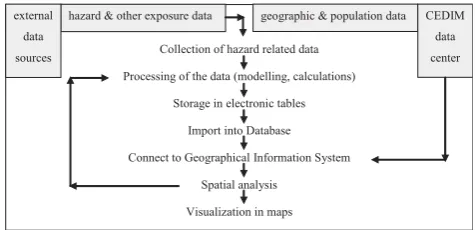
Collection of hazard related data
Processing of the data (modelling, calculations)
Storage in electronic tables
Import into Database
Connect to Geographical Information System
Spatial analysis
Visualization in maps
geographic & population data CEDIM
data
center hazard & other exposure data
external
data
sources
Fig. 2. Flowchart for the visualisation of information.
3 Processing and visualization of information
The presented typology of risks clearly shows that human-induced risks are very heterogeneous. As a consequence, it is hard to find spanning scientific concepts and studies as well as detailed overall event data for this field of research. Haimes (1998) gives a comprehensive summary of work in risk assessment in general.
In order to implement the risk analysis concept through mapping, Geographic Information Systems (GIS) and database systems are widely used. Our data collected from diverse sources is processed for modelling and calculation purposes. If necessary, extraterritorial experiences serve as a backup for the collection of corresponding German data at the micro-, meso- and macro level. Data collection, process-ing and visualization procedures are illustrated in Fig. 2.
Hazard and exposure related statistical data are collected from both primary and secondary sources including the inter-net and concerned organisations such as authorities or com-panies. The data of potentially hazardous objects or ex-posed elements (stadiums, NPP, etc.) include real world ge-ographic coordinates, addresses, and hazard specific infor-mation which are stored in tables (Microsoft Excel). After-wards, they are imported into a database management system software (MySQL) for further analysis and data base opera-tions before being included into the GIS software (ESRI11 ArcGIS) for spatial analyses.
Different geo-data such as administrative boundaries, road network, rivers, digital elevation models as well as popula-tion data at different resolupopula-tions within the spatial framework of Germany are gathered internally from the CEDIM data center and handled with ArcGIS software.
ArcGIS provides various facilities for the spatial analysis and visualization of data: The buffer function, e.g., allows to create buffer polygons to a specified distance around an input feature. We use this in order to model air traffic risk by designing buffers around airports (cf. Sect. 4.2). The overlay
11Environmental Systems Research Institute (ESRI), one of the
786 D. Borst et al.: A methodology to assess man-made risks in Germany
Table 3. Factors influencing the hazard of radioactive releases from German NPP at facility level.
Influencing factor Mode of influence Characteristic values in
Germany1
Power2 The maximum quantity of radioactivity to be released from a
NPP depends on its inventory. More power means a bigger inventory (not proportional, though, as both technology and efficiency of the plant must be taken into account).
The NPP have an electri-cal power of 806 MW up to 1400 MW.
Reactor type3 In Germany two different types exist: Pressurized water
reac-tors (PWR) and boiling water reacreac-tors (BWR). PWR are in-trinsically safer because they have two separate cooling water circulations, the steam in the reactor is from a separate source and the special construction cares for a falling pressure with a rising temperature.
11 PWR, 6 BWR
Age4 Aging in NPP causes different problems:
- Technical: Mechanical components, buildings and built in-frastructure, electronic and information technologies - Operation systems
- Documentation
- Maintaining quality of staff (loss of employees, difficulties in finding well-educated personnel)
In 2005 the NPP had an average age of 23.4 years, with the oldest one being built in 1974, the most re-cent one in 1989.
1Cf. Bundesamt f¨ur Strahlenschutz (BfS, Federal Office for Radiation Protection) – Kernkraftwerke in der Bundesrepublik Deutschland
(Nuclear Power Plants in Germany), http://www.bfs.de/kerntechnik/ereignisse/standorte/karte kw.html [17/03/2006].
2Own consideration and comparison with the exposure rates of NPP in normal operation as published by Koelzer (2005).
3 Technical details can be found at http://www.wien.gv.at/wua/atom/glossar/s.htm and http://leifi.physik.uni-muenchen.de/web ph10/
umwelt-technik/13kkw/index.htm [both 17/03/2006].
4Cf. considerations of RSK (2004).
function combines different layers and creates a new layer with combined attributes. For example, after having created a buffer zone around NPP, it can be overlaid with a population density layer to extract further attributes (cf. Sect. 4.1).
Thus, the spatial analysis functionality of GIS can reveal new aspects, and thereby help to analyse and understand the effects of any disaster. This may improve the risk modelling process. In addition, the GIS facilitates the illustration of hazard, exposure, and risk by various maps that can be cre-ated within the computer system.
4 The implementation of the risk assessment concept: mapping man-made risks
4.1 Nuclear power plants
At present, 17 NPP with a total power of 21 GW are operat-ing in Germany. The German government has decided to de-commission all German NPP within the next twenty years12 due to the aging of the facilities, extensive public discussion 12Deutscher Bundestag: Gesetz zur geordneten Beendigung der
Kernenergienutzung zur gewerblichen Erzeugung von Elektrizit¨at.
(German Parliament: Law concerning the orderly termination of nuclear energy usage for commercial production of electricity)
on the safety of these plants and problems with safe storage of atomic wastes. As long as these governmental plans are not fully carried through, it is worthwhile to consider this wide-ranging hazard. We focus on short-term effects of pos-sible, although low-probability, releases of radioactive sub-stances during continuous operation.
4.1.1 State of the art and results of previous risk assess-ments
The hazardousness of NPP originates from potential releases of radioactive substances. It is affected by the amount of radioactive materials contained in the facilities and by their technical standards regarding substance release prevention. Institutions like the Gesellschaft f¨ur Anlagen- und Reaktor-sicherheit (GRS, Society for Facility and Reactor Safety) – a German organization responsible for supervising technical aspects of nuclear power plants – have been publishing de-tailed studies about safety issues in such facilities (cf. GRS, 2005). Based on these studies we derive some primary fac-tors influencing the hazard of radioactive releases in German NPP. They are shown in Table 3.
technical safety for all German NPP13. PSA is meant to es-timate the likelihood of an accident with damage to the core of the reactor or one that cannot be enshrined by the internal safety barriers of the plant, respectively. The estimates are made by looking at both the technical components of the re-actor and the safety barriers for each scenario defined. A methodology including large event trees and several com-puter models is used to analyse possible events of impor-tance. Although the methodology by itself is probabilistic, the results are not: Only few likelihood values for certain de-terministic events are given without distinguishing between different release intensities. This does not allow any further probabilistic analysis of the release hazard. The probability for core melt phenomena (core damage frequency, CDF, as one kind of events considered) of all intensities of a German NPP lies between 2.0E-07 and 5.3E-06 per year. Figure 3 gives some examples of CDF values for German plants.
PSA allows figuring out and improving the problems which the technical safety concept might include (cf. Berg, 2004). But PSA does not yet contain information on other factors relevant to the hazard of radioactive releases. For ex-ample, the source term (or its probability function, respec-tively) is determined by constructional characteristics of the reactor like its type and electrical power produced. These are incorporated into PSA whereas the factor “type of incident” is only partly worked in. The aging of NPP (cf. Smith et al., 2001)14as well as human mistakes and errors in connexion with the general safety management in plants are also not covered. As a consequence, there is, e.g., continuous effort to systematically incorporate aging phenomena into the de-termination of PSA values. In Europe, a research “Network on Incorporating Ageing Effects into Probabilistic Safety Assessment (APSA)” funded by EU has started to address this task since 2004.15 Regarding the safety management or safety culture in the operating company, M¨uller et al. (1998) and Sorenson (2002) conclude that human aspects should be considered an integral part of safety systems. They show up in organizational performance and individual striving for safety in the work area. Employees leaving the NPP take away a lot of valuable knowledge. Therefore, it is necessary to train the staff continuously and to educate new personnel. The last part of this claim is a problem for German plants be-cause of the intended shutdowns of NPP which makes these jobs less attractive. According to our own findings,16 19.9%
13For an overview on foundations and methods of PSA as a
stan-dardized successor of former probabilistic approaches called Prob-abilistic Risk Analysis, cf. Bedford and Cooke (2001).
14One problem with respect to aging of the plants is that they
contain steel reactors that wear out. The microscopic splitting of a steel reactor can only be measured by complicated analyses.
15 APSA website: http://www.energyrisks.jrc.nl/APSA/
[19/03/2006].
16Calculations based on http://www.bfs.de/kerntechnik/
ereignisse/berichte [19/03/2006].
PSA Results for core melt in German NPP
3. 6 E -0 6 1. 6 E -0 6 2. 0 E -0 7 2. 0 E -0 7 3. 8 E -0 6 1. 4 E -0 6 5. 3E -06 0.0E+00 1.0E-06 2.0E-06 3.0E-06 4.0E-06 5.0E-06 6.0E-06 Bibl isB Neckar west heim 1 Unte rwes er Pr e-KONV OI* Brun sbüt tel Isar 1 Krüm mel Fr eq ue nc y 1/ y
*Pre-KONVOI is a modern reactor type with a high requirement on safety. NPP are Grohnde, Grafenrheinfeld, Philippsburg 2, and Brokdorf.
Fig. 3. PSA results for German NPP. Data source: Bundesamt f¨ur Strahlenschutz (BfS, Federal Office for Radiation Protection).
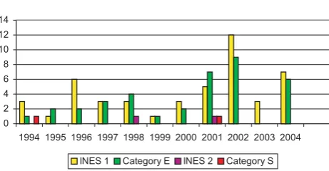
of unwanted events (reportable events, cf. Sect. 4.1.3) in Ger-man NPP during the period of 1994–2004 were caused by human errors and mistakes.
Despite their omissions and limitations, concepts like PSA have been forming the basis of advanced technical studies regarding the risk of NPP. Some studies – for example, US NRC (1990) – are very complex and require lots of technical knowledge as well as an extensive amount of data. Consider-ing the fact that this data is not always available in the qual-ity needed for detailed analysis, other studies like Schmidt-Thom´e (2006) use simplified concepts and indicators.
The ESPON-project as outlined in Schmidt-Thom´e (2006) is a study covering risks of different hazards. It uses a very simple hazard indicator with respect to NPP, namely the ex-istence of a plant in operation. Based on the experiences of the Chernobyl accident, it is assumed that a NPP imposes a very high hazard for its immediate neighbourhood within a radius of 30 km, a medium hazard for the surrounding area of up to 300 km and no hazard for greater distances. Vulnerabil-ity is not modelled case-specifically with respect to different hazards in this study.
The study of Kromp et al. (1999) is a recent example for detailed hazard research based on quantitative safety anal-ysis values like PSA. It was done on behalf of the Expert Authority of the ¨Osterreichisches Umweltbundesamt (Aus-trian Federal Office for Environmental Protection and Con-trol). The authors investigate the probability of radiological exposure stemming from all European NPP. With respect to the likelihood of release events, the study uses values gener-ated probabilistically similar to PSA17. The source term of all substances and their amounts released, thereby determining the local intensity of a radioactive hazard, is given by em-ploying one typical scenario. The subsequent deposition of nuclear substances to the ground is calculated by using a sim-ulation of certain meteorological conditions determining the
17One part of the study uses Large Release Frequencies for each
788 D. Borst et al.: A methodology to assess man-made risks in Germany
Reportable events (INES = 1, Category = E)
0 2 4 6 8 10 12 14
1994 1995 1996 1997 1998 1999 2000 2001 2002 2003 2004
INES 1 Category E INES 2 Category S
Fig. 4. Number of reportable events of German NPP between 1994 and 2004 (Data: BfS).
spreading of radioactive agents. As a result, the researchers created a map showing the geographical distribution of the probability of being exposed to radioactivity, and tables indi-cating the radiological exposure of various countries. Unfor-tunately, the study is almost completely limited to the hazard part of the risk and – with the only exception of a value of soil contamination – neglects the elements at risk exposed to it (like humans and property), and their vulnerability.
Since there is usually no direct damage to property due to radioactivity releases except to the plant area itself we fo-cus on humans with respect to exposure and vulnerability. Complex connexions in the absorption of radiation doses by the human body may generate a broad array of medical con-ditions. At least two assessment strategies regarding health risks can be discerned in the literature: A very detailed ap-proach is used, e.g., by BMU (2001) or US NRC (1990), and a simplified approach is used by Weil (2003).
Weil (2003), head of the core safety department of the BfS, assesses the monetary value of health risks and property dam-age for the hazard scenario of a major accident at the German NPP located in Biblis. The health risk considered is defined as the danger of getting cancer, which leads to costs for treat-ment or lethal consequences. For determining health risks Weil (2003) does neither differentiate between ways of in-corporation of radioactivity nor between certain groups of the population as stemming from gender and age, but just gives an average percentage of people affected. This ratio is multiplied with the number of the local population. Together with assumptions on treatment costs and costs of lethality as given by Ottinger et al. (1990) and Hohmeyer (1989), the sum of health costs is obtained and added to the costs due to property damages.
BMU (2001), in contrast, demonstrate clearly that calcu-lating health effects and health costs from radiological activ-ity rates can be an extremely complex task. They distinguish between different medical mechanisms caused by different forms of incorporation of radioactivity to the human body – via external radiation, breathing and ingestion – while con-sidering that these effects are also influenced by dose
mitiga-tion measures of emergency response acmitiga-tions.
Another study, US NRC (1990:3–17), which includes both hazard and vulnerability assessment, distinguishes four types of indicators for determining the vulnerability of humans to-wards radioactive releases, i.e. early fatality risk, latent can-cer fatality risk, population dose within 50 miles of the site and population dose within the entire site region. The values, however, are calculated only for certain US-plants and they are based on assumptions covering both the local technical plant features as well as their environment. Consequently, the assessment cannot be directly transferred to the German context. Furthermore, the calculations are, again, quite com-plex and go beyond the scope of this study.
4.1.2 Data for assessing the risk of NPP
Existing PSA values for German NPP can serve as a basis for hazard assessment. Since this primary indicator has some shortcomings, we have looked for data in support of other ap-proaches suitable to flank PSA values. Besides that, Green-peace states a critical view of relying solely on this main-stream indicator and shows contradictory study results with respect to the assessment of nuclear risk (cf. Greenpeace, 1998).
Since 1975, BfS has constantly supervised the nuclear fa-cilities and regularly informed the public about all German NPP both on basic technical data like reactor types, inven-tory, starting time of operation and age, respectively, as well as on their findings regarding the safety of the plants. Back-ing their work, by the act of law a reportBack-ing system was installed to document safety problems, enabling the BfS to publish descriptive findings from statistical evaluations on reported incidents.
In the case of an unwanted event taking place in a facil-ity, the operating company (operator) is obliged to report to the BfS (reportable events). The operator documents, catego-rizes and publishes these events in order to improve the safety status in the plants. The German scaling system for these re-portable events is categorized into 4 levels: S, Sofortmeldung (immediate notification); E, Eilmeldung (urgent notification, report within 24 h after the event); N, Normalmeldung (nor-mal notification, 5 days) and V, Vor Beladung des Reaktors (before charging the reactor, 10 days). The internationally applied INES (International Nuclear Events Scale) system differs from the German scaling as it is using a numerical system: No significance (category 0), termed incidents (1– 3), and termed accidents (4–7).
Between 1994 and 2004, according to BfS, German NPP reported 2300 events but none was categorised higher than INES 2, as illustrated in Fig. 4.
densi-ties18 within the communities as calculated by Thieken et al. (2006). Their study is based on information on residential population provided by INFAS Geodaten (2001) as well as on land use information developed by the European project CORINE land cover (CLC).
4.1.3 Methods for assessing and mapping the nuclear risk in Germany
Despite the limitations already discussed in Sect. 4.1.1, some results of former studies on nuclear risk are fundamental to the development of our methodology for assessing and map-ping the risk of NPP in Germany.
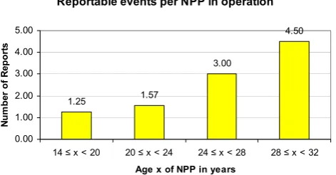
In our studies done on NPP aging19the following contin-gency between the frequency of reportable events of INES 1 and 2 and the facilities’ age can be observed.
Figure 5 shows the number of reports in German reactors which are categorized into age-classes for a better overview. In Germany, 17 NPP are in operation, none is older than 32 years and none is younger than 14 years20. The reports of all NPP counted over a period of the last 11 years are used. They are categorized as INES 1 or 2 without exception. The differ-ence in severity of these categories is taken into account by a weighting factor two for INES 2 events which means that these events are counted twice. Although the set of NPP is small, Fig. 5 clearly shows that the older reactors have more reportable events. This is in line with research conducted on aging of NPP in different parts of the world: With respect to the risk of core damages, studies mention “from 10 to more than 1000% [of] increasing by year in operation” (Vesely et al., 1990 as cited in IRSN, 2005:16) for CDF. For our hazard assessment we, therefore, include a correction factor based on empirical findings reflecting the age of the facilities.
The hazard per se is of international dimensions, espe-cially due to the influence of meteorological conditions such as direction and speed of wind, stability of atmospheric lay-ers, humidity, and rainfall. Together they form a very com-plex interplay of factors impinging on the dispersion of the nuclear agent. Kromp et al. (1999) argue conclusively that up to 89 percent of the probability of radiological exposure in Germany stem from foreign countries. Unfortunately, this has to be considered a rough estimate, as the data on NPP in foreign countries, if available at all, are not directly com-parable to the data on German reactors, thus imposing great uncertainties with respect to this hazard. As there is hardly any justification to model the dispersion of radioactivity for
18A homogeneous mean population density is assumed in areas
with the same land use. The mean values are corrected per commu-nity.
19While most international studies on this topic like Smith et
al. (2001) are cause-based, i.e. an aging reliability-physics model is applied to the existing PSA risk model, our approach, on the con-trary, is effect-based.
20In 2004, source: http://www.bfs.de/kerntechnik/ereignisse/
standorte/karte kw.html [19/03/2006].
Reportable events per NPP in operation
1.25 1.57
3.00
4.50
0.00 1.00 2.00 3.00 4.00 5.00
14 ≤ x < 20 20 ≤ x < 24 24 ≤ x < 28 28 ≤ x < 32 Age x of NPP in years
N
um
be
r of
R
epor
ts
Fig. 5. Reports per NPP in operation
Figure 5 shows the number of reports in German reactors which are categorized into
age-classes for a better overview. In Germany, 17 NPP are in operation, none is older than 32
years and none is younger than 14 years25. The reports of all NPP counted over a period of the
last 11 years are used.They are categorized as INES 1 or 2 without exception. The difference
in severity of these categories is taken into account by a weighting factor two for INES 2
events which means that these events are counted twice. Although the set of NPP is small,
Figure 5 clearly shows that the older reactors have more reportable events. This is in line with
research conducted on aging of NPP in different parts of the world: With respect to the risk of
core damages, studies mention “from 10 to more than 1000 % [of] increasing by year in
operation” (Vesely et al., 1990 as cited in IRSN, 2005: 16) for CDF. For our hazard
assessment we, therefore, include a correction factor based on empirical findings reflecting
the age of the facilities.
The hazard per se is of international dimensions, especially due to the influence of
meteorological conditions such as direction and speed of wind, stability of atmospheric layers,
humidity, and rainfall. Together they form a very complex interplay of factors impinging on
the dispersion of the nuclear agent. Kromp et al. (1999) argue conclusively that up to 89
percent of the probability of radiological exposure in Germany stem from foreign countries.
25
In 2004, source: http://www.bfs.de/kerntechnik/ereignisse/standorte/karte_kw.html [19/03/2006].
24
Fig. 5. Reports per NPP in operation.
Germany without detailed information from abroad, we con-fine ourselves to the local areas, which would be undoubt-edly and severely affected by a radioactive release. In BMU (2001), a buffer zone with a radius of 30 km around a plant is proposed for immediate action regarding protection mea-sures.21 We introduce the same buffer zone in our modelling and mapping approach.
To sum up our considerations on the choice of an appropri-ate model, we decided to use a simple hazard model based on information available for Germany, i.e. PSA values and age data combined with empirical findings on the number of in-cidents, resulting in the following index:
Hazard indexh=f (PSA, age factor) (1) In detail, we use an age factor reflecting the relative in-crease in reportable events for NPP of different age classes compared to the youngest cluster. These factors ranging from 1 for the most recently built class of reactors to 3.622 for the oldest NPP are multiplied with the PSA value for each plant. The resulting values are then normalised, i.e. the high-est value is given the index value 1 while the other values are adjusted accordingly.23 Consequently, the “safest” plant is assigned an index value of only 0.0146 in comparison with 1.00 for the most hazard prone one.
As we do not model dispersion effects, we cannot calcu-late detailed health risk and consequently only include the predecessor of such calculations in our vulnerability model, namely values of population densities. This results in the following index:
Vulnerability indexv=f (population density within
a radius of 30 km around NPP) (2)
21This is the same radius as chosen for evacuation following the
Chernobyl accident.
22The NPP pertaining to the oldest age-class had to report on
average 3.6 times as many events as the most recently built NPP, i.e. 4.5 reports/1.25 reports.
23The respective product of PSA and age factor is divided by the
790 D. Borst et al.: A methodology to assess man-made risks in Germany
Stuttgart Karlsruhe
Mannheim Ludwigshafen
Pforzheim
Heilbronn
Ludwigsburg Heidelberg
Obrigheim
Philippsburg 2
Neckarwestheim 2 Neckarwestheim 1
Nuclear power plants at Neckarwestheim and Philippsburg -local risk influenced by PSA values, aging factors and population densities
Institute for Finance, Banking and Insurance, University of Karlsruhe (TH) Data Source: CEDIM data center
Legend
Nuclear power plants
Roads
Community boundaries
Risk Index values within buffers (theoretical max. value = 10,000)
0 - 15
> 15 - 40
> 40 - 400
> 400 - 1000
> 1000 - 3862
0 5 10 20 30km
Fig. 6. Local risk map around the nuclear power plants Neckarwestheim 1, Neckarwestheim 2 and Philippsburg 2.
Population density values in Germany vary between 0 and 14 419 inhabitants per km2for areas of homogeneous mean population density within a community as given by Thieken et al. (2006). This data is again normalised for mapping pur-poses to obtain values between 0 and 1.24
For calculating the final risk index r within the buffer zones, we multiply the hazard index valueshand the vul-nerability index valuesv. Due to the normalisation effected in the former steps, this results in very low values of magni-tudes smaller than one. That is why this product is multiplied by 10 000 for displaying purposes, leading to the formula:
Risk indexr=h∗v∗10 000 (3)
24As mentioned before, these values only reflect the residential
population, which means at night-time. People moving in or out of certain areas during day-time – for work, school, shopping, etc. – are not registered. For a more detailed approach see Balmforth et al. (2005).
4.1.4 Results of the risk assessment
Looking at the spatial distribution of NPP reveals that most of them are located at the northernmost and southernmost parts of Germany with some agglomeration at a very close distance to each other. Figure 6 – as an example of the re-sults of this risk assessment process – shows the environment of three German reactors at Neckarwestheim and Philipps-burg including both hazard and vulnerability information. Within a radius of 50 km of these plants one further reactor (Philippsburg 1) cannot be taken into account due to missing PSA values (although PSA values exist for all 17 NPP, they have been published only for 10 NPP so far), a second one (Obrigheim) was decommissioned in May 2005.
It is evident that some cities25are located within the buffer zones of 30 km around the NPP. Their population is endan-gered, therefore, by nuclear accidents. In the exemplary case
25These are Karlsruhe, Mannheim, Ludwigshafen and
mapped in Fig. 6, the values of the risk indexrvary between below 1 (very low risk) for nearly one fourth of the cases and above 1000 (high risk) for the top 3.6 percent, the ma-jority of the values (64%) being at a low to medium level of risk between 1 and 100. Although many densely populated cities are located near the Philippsburg plant, the highest in-dex value within these cities is 139 (for parts of Heidelberg), at a medium level of risk. This is due to the low hazard in-dex valuehfor NPP Philippsburg (0.018) which is nearly 24 times lower than the sum of those for the Neckarwestheim plants (0.421+0.015=0.436). Consequently, areas with con-siderably higher values of risk (above 3000) are located in Stuttgart, Ludwigsburg, Heilbronn, and Fellbach where both hazard and vulnerability values are elevated. The risk index values for the area located in the intersection of the buffer zones around the NPP are still low because of the very low population density there.
4.1.5 Discussion of the NPP risk assessment approach The methodology and parameters chosen for building our risk index are subject to discussion. Within a multi-hazard study of limited scope, the degree of detail in the assessment of hazard, vulnerability and risk has to be chosen carefully.
For the hazard assessment regarding plant safety, it seems reasonable to draw upon the scientifically accepted concept of PSA supplying individual values for each reactor. Other approaches use no distinction between different plants as in Schmidt-Thom´e (2006) or only values for certain reference NPP and minimum safety goal values, respectively (Kromp at al., 1999). Adding correction factors based on statistical findings can help to overcome the problem of passing over aging effects by PSA. Nevertheless, the use of PSA for Ger-man NPP is limited due to the nondisclosure of the results for some plants thus restricting the implementation of the methodology for whole Germany as for now. Further re-search should incorporate all existing values.
Regarding the vulnerability assessment, we use population density information at the highest resolution available for dif-ferentiation with respect to this parameter. Since a more de-tailed assessment of the vulnerability of people by in-depth medical considerations cannot be part of this study, it is left to further research. One step that should also be included in fu-ture research is a consideration regarding the whereabouts of people during day-time. Other very important aspects within the risk of NPP are indirect economic effects, which are to be subsumed under vulnerability assessment, too. However, within the first stage of the framework of the overall CEDIM project they are not included in the considerations.
As a conclusion, the risk index is a simple approach for assessing the risk due to NPP. It is specifically adopted to the characteristics of this very complex form of risk and, there-fore, hardly comparable to our assessment of other forms of man-made perils.
4.2 Air traffic
In Germany, there are 17 international airports (as of 2004) and some regional airports handling in total about 2.7 mil-lion Instrument Flight Rules (IFR) flights26 per year as well as even more small airports exclusively used for air sports purposes. Deutsche Flugsicherung (DFS, German Organi-sation for Flight Security) controls and guides the non-sport flights from start till landing. The number of flights as well as of passengers and goods transported has been dynamically growing (on average by 5.3 percent per year within the last 20 years; DFS, 2005). Thus, the structure of air traffic has been changing, too: Low fare airlines have entered the mar-ket once dominated by mostly state-owned airlines, also di-verting some traffic from main airports within metropolitan areas to more or less remote regional airports that are often subsidized by local state governments. Due to the difficult economic situation of these regional airports – depending on subsidies and the continuous devotion of few low fare air-lines making up the main share of their business – it is hard to predict their future and thus the accurate regional distribu-tion of flights in Germany. Apart from decentralized traffic, the big airports too have seen substantial growth and there have been constant construction works going on at many of them to cope with the increasing competition and volume of flights. In consequence of these structural changes, the following assessment of the regional distribution of risk due to air traffic has to be seen as a temporary snap-shot. The assessment method, however, can be further developed and used for risk updates.
4.2.1 State of the art of assessment of air traffic risk Over the years, there have been common efforts of govern-ment authorities, science and the commercial stakeholders of air traffic (aircraft industry, airlines, airports, air traffic con-trols) to reduce the hazard due to air traffic despite the in-crease in traffic volume. In Germany, Bundesstelle f¨ur Flug-unfalluntersuchung (BFU, German Federal Bureau of Air-craft Accidents Investigation) is in charge of collecting data on civil air traffic accidents and the investigation thereof. On the European level, within the conjoint project European Co-ordination Centre for Aviation Incident Reporting Systems (ECCAIRS)27of the membership countries, a databank sys-tem has been developed for the collection and analysis of air traffic accidents. In the US, extensive data on such accidents as well as on near misses is stored in specific databases estab-lished by the National Aviation Safety Data Analysis Center (NASDAC) as part of the Federal Aviation Administration28.
26IFR: Flights are operated using the plane’s instruments, not
only human sight.
27Website: http://eccairs-www.jrc.it/Start.asp [20/03/2006].
28Aviation Accident and Incident Data System (AIDS), Aviation