www.nat-hazards-earth-syst-sci.net/12/1923/2012/ doi:10.5194/nhess-12-1923-2012
© Author(s) 2012. CC Attribution 3.0 License.
and Earth
System Sciences
Development of tsunami early warning systems and
future challenges
J. W¨achter1, A. Babeyko2, J. Fleischer3, R. H¨aner1, M. Hammitzsch1, A. Kloth3, and M. Lendholt1 1Helmholtz Centre Potsdam, GFZ German Research Centre for Geosciences, CeGIT Centre for GeoInformation Technology, Germany
2Helmholtz Centre Potsdam, GFZ German Research Centre for Geosciences, Section 2.5: Geodynamic Modelling, Germany 3SpaceTech GmbH, Seelbachstrasse 13, 88090 Immenstaad, Germany
Correspondence to: J. W¨achter ([email protected])
Received: 19 December 2011 – Revised: 6 May 2012 – Accepted: 15 May 2012 – Published: 18 June 2012
Abstract. Fostered by and embedded in the general develop-ment of information and communications technology (ICT), the evolution of tsunami warning systems (TWS) shows a significant development from seismic-centred to multi-sensor system architectures using additional multi-sensors (e.g. tide gauges and buoys) for the detection of tsunami waves in the ocean.
Currently, the beginning implementation of regional tsunami warning infrastructures indicates a new phase in the development of TWS. A new generation of TWS should not only be able to realise multi-sensor monitoring for tsunami detection. Moreover, these systems have to be capable to form a collaborative communication infrastructure of dis-tributed tsunami warning systems in order to implement re-gional, ocean-wide monitoring and warning strategies.
In the context of the development of the German In-donesian Tsunami Early Warning System (GITEWS) and in the EU-funded FP6 project Distant Early Warning Sys-tem (DEWS), a service platform for both sensor integration and warning dissemination has been newly developed and demonstrated. In particular, standards of the Open Geospatial Consortium (OGC) and the Organization for the Advance-ment of Structured Information Standards (OASIS) have been successfully incorporated.
In the FP7 project Collaborative, Complex and Critical Decision-Support in Evolving Crises (TRIDEC), new devel-opments in ICT (e.g. complex event processing (CEP) and event-driven architecture (EDA)) are used to extend the exist-ing platform to realise a component-based technology frame-work for building distributed tsunami warning systems.
1 Introduction
The Boxing Day Tsunami in 2004 triggered various interna-tional efforts focused on tsunami early warning for the In-dian Ocean Basin. Stimulated by developments in the field of tsunami science and information and communications technology (ICT), the technological concepts of tsunami early warning systems (TWS) have been improved consid-erably. The warning system architecture has been specifi-cally addressed in two complementary projects: firstly, Ger-man Indonesian Tsunami Early Warning System (GITEWS), funded by the German Federal Ministry of Education and Research BMBF, and, secondly, Distant Early Warning Sys-tem (DEWS), a European project co-funded under FP6. The development is continued by the FP7 large-scale inte-grated project Collaborative, Complex and Critical Decision-Support in Evolving Crises (TRIDEC).
further constrain forecasting uncertainty. In order to inte-grate these heterogeneous upstream sensor data flows, an in-tegration platform for sensor systems, the GITEWS Tsunami Service Bus (TSB), has been implemented (Fleischer et al., 2010).
Complementary to the TSB, DEWS addressed the down-stream flow of information from a TWS to different types of message recipients. For this purpose procedures and compo-nents for the dissemination of customised warning messages and tsunami bulletins in a multilingual environment, suited for a broad range of individual message recipients, have been developed. Additionally, the information flow between na-tional TWS in the Indian Ocean Basin (i.e. Indonesia, Thai-land, and Sri Lanka) has been analysed and a basic concept for a wide area warning centre communication has been de-veloped.
Both projects delivered contributions for the drafting and promotion of an initial concept for a service platform for TWS and developed a set of modules for the construction of warning centres in general. These results provided substan-tial input for TRIDEC focusing on new concepts of ICT for real-time intelligent information management in Earth man-agement. One key topic is the design and implementation of a robust and scalable service infrastructure supporting the management of crisis situations, e.g. in the context of and resulting from tsunami disasters. The event-driven behaviour of this type of complex infrastructures is of special impor-tance for the design and the core components of the TRIDEC architecture.
All research and developments activities have been and will be guided by the ongoing work of Intergovernmental Oceanographic Commission of UNESCO (UNESCO/IOC) on the implementation of tsunami warning systems. In-tergovernmental Coordination Groups responsible for the implementation of regional tsunami warning infrastruc-tures (e.g. Intergovernmental Coordination Group for the Indian Ocean Tsunami Warning and Mitigation System (ICG/IOTWS) or the Intergovernmental Coordination Group for the Tsunami Early Warning and Mitigation System for the North-eastern Atlantic, the Mediterranean and Connected Seas (ICG/NEAMTWS)) have developed concrete imple-mentation plans, including service levels and performance indicators (UNESCO, 2011; ICG/NEAMTWS, 2011).
In this paper we present the results of our research and de-velopment activities in the field of TWS with the specific fo-cus on system architecture and system components. In Sect. 2 we will address aspects of the architecture of tsunami warn-ing systems in general, includwarn-ing design criteria, information flows and main architectural building blocks. Subsequently, in Sects. 3, 4, and 5, the building blocks and main compo-nents are described in detail. The paper concludes with an overview about future challenges for tsunami warning sys-tem technology.
2 Architecture of tsunami warning systems
2.1 Design criteria
TWS are long-lasting and successively evolving systems. In their life-time new sensor systems, as well as decision sup-port and warning dissemination components, will be devel-oped. Old components therefore have to be replaced, and both new functionality and improved software versions have to be deployed. Beyond that, it is probable that business pro-cesses and operational procedures have to be modified or added (H¨aner and Kriegel, 2008). As a consequence the ar-chitecture of tsunami warning systems has to be flexible and adoptable by complying with the following design criteria (Erl, 2008):
– Abstraction and encapsulation of data and functionality on data in standardised services: the access to the pro-prietary sensor data can be achieved via well-defined interfaces specified in appropriate service contracts. In-terfaces that can be used in TWS to access heteroge-neous sensor systems are comprehensively described in the Sensor Web Enablement (SWE) specifications of the OGC.
– Loose coupling of system components: coupling refers to the degree of direct knowledge that one component has of another and aims at resilient relationship between two or more systems and components. Loose coupling reduces the risk that a change made within one compo-nent results in unanticipated changes within other com-ponents. It also minimises the dependencies on each other to the least practicable extent.
– Location transparency of services: services can be pro-vided everywhere and can be re-used in a federation of systems. Location transparency enables infrastruc-tures that integrate proprietary and heterogeneous ap-plications. Thus, it is possible to share and integrate re-sources beyond static utilisation to dynamically request information.
– Separation of concerns: breaking a system into distinct features that overlap in functionality as little as possi-ble. This allows services to be commonly used and com-bined within different business processes. Thus, distinct components processing information independently can be utilised in other domains as well.
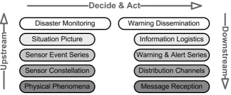
Fig. 1. Upstream and downstream flow of events and information
in early warning systems (W¨achter et al., 2009; Lendholt and Ham-mitzsch, 2011).
providing a standards based integration platform for hetero-geneous resources (Chappell, 2004). In particular, standards of Open Geospatial Consortium (OGC) and Organization for the Advancement of Structured Information Standards (OA-SIS) have been incorporated.
2.2 Information flows
According to USIOTWS (2007) the key operational compo-nents of a TWS are to provide real-time monitoring, alert of seismic and tsunami activities, timely decision making, and dissemination of tsunami warnings, advisories, and in-formation. A TWS enables and controls upstream and down-stream information flows. The overall information flow in-cludes three segments (Fig. 1):
1. Upstream: acquisition of sensor data and transmission to the warning centre, including processing and event detection;
2. Decide-and-act: information flows within the warning centre, including situation analysis, decision support and warning dissemination planning;
3. Downstream: preparation of customised tsunami mes-sages for the dissemination via selected channels. The upstream information flow delivers observations about physical phenomena measured by sensor systems necessary for decision support processes into the warning centre. For each sensor system the upstream includes complex process-ing and transformation steps. Time series data measured by sensors have to be filtered and analysed in order to extract relevant events for decision making. The resulting aggre-gated data sets represent the input important for the deci-sion support components of the TWS. The concrete decideci-sion processes are executed in the decide-and-act segment of the overall information flow. In this segment sensor events have to be analysed in order to determine if a tsunami has been triggered. Depending on this decision, the concrete risks for defined coastal areas have to be determined. This process is supported by what-if prognostic tsunami propagation models delivered by the simulation component. Based on this input
the downstream information flow includes the transformation of tsunami hazard information into customised warning mes-sages and situation reports delivered to defined target groups, including authorities, the public in case of emergencies, and other regional as well local warning centres.
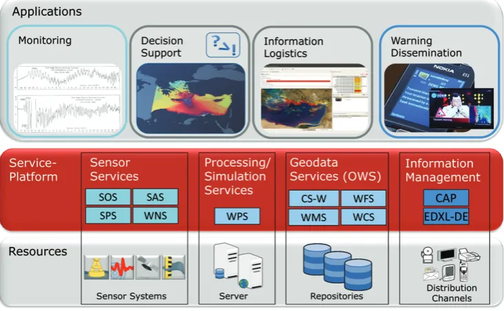
2.3 Overall architecture
Following a simplified SOA model, a warning system sup-porting the information flows outlined above consists of three layers (Fig. 2). The basic layer comprises a pool of resources including, for example sensor systems and compute servers, as well as databases for spatial data and context information and also access points to warning dissemination channels. These resources are accessible via a set of services:
– Sensor services for the monitoring of earthquake activi-ties and sea level changes make use of services specified in SWE documents of the OGC.
– Decision support services support the detection of tsunami and the planning of warning activities, and as-sociated components and services support prognostic modelling and the management of context information. Standardised OGC Web Services (OWS), i.e. Web Map-ping Service (WMS), Web Processing Service (WPS), and Web Feature Service (WFS) help to create the over-all situation picture and support the prognostic tsunami wave simulation.
– Information logistics and dissemination services han-dle the downstream information flow and are responsi-ble for compiling and disseminating customised warn-ing messages. OASIS standards, mainly the Common Alerting Protocol (CAP) and the Emergency Data Ex-change Language – Distribution Element (EDXL-DE) provide the foundation.
Fig. 2. Schematic architecture of multi-sensor warning systems. The access to computing services, sensor systems, repositories, and
distri-bution channels is realised via standardised interfaces.
the current situation, to determine the hazard status in rel-evant coastal areas and in case of need to initialise the tar-geted dissemination of customised warning messages (Ham-mitzsch and Lendholt, 2011). The other main function of the CCUI is the management of downstream activities, includ-ing the generation and dissemination of specific customised warning products for defined target groups.
3 Upstream
3.1 Information processing
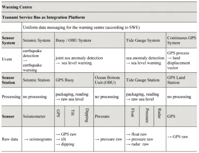
The upstream information flow from the sensor system to the warning centre is characterised by a stepwise process-ing of raw event data comprocess-ing from the sensors into deci-sion relevant information that is used in the warning centre. Processing includes the filtering of time series data and the extraction of significant changes (i.e. events). Additionally, the upstream process includes the merging with other events and the amendment of context information (e.g. sensor sta-tus data). Signals measured by the sensor are transformed into context and decision relevant information. For example, irregular signals extracted from Earth tremor measurements of geographically distributed geophones are combined and become earthquake information. Upstream information pro-cessing results in a considerable reduction of data volumes. Table 1 summarises the information refinement in GITEWS for different sensor types. The columns represent the different types of sensor systems, i.e. seismic (Hanka et al., 2010), buoy and ocean bottom unit (Sch¨one et al., 2011a),
tide gauge (Sch¨one et al., 2011b), and cGPS (Falck et al., 2010) systems. Vertically, from the bottom to the top, the se-quence of processing steps and their respective results are displayed. For example, the tide gauge system collects water level data using three independent sensors (radar, float, pres-sures) reducing the risk for a complete sensor failure caused by the impact of a tsunami wave. The different data streams are then packaged and distributed by the sensor station to the tide gauge system of the responsible agency, forwarding it to the national TWS. In its turn the tide gauge system inte-grates the incoming three raw data streams into a single sea level measurement (at a given place and time). By examining the resulting time series for anomalies, the tide gauge system eventually alerts the TWS if any anomalies were found.
3.2 Sensor integration
Fig. 3. Upstream, decide-and-act, and downstream segments unfolded and mapped to system components (Lendholt and Hammitzsch, 2011).
Table 1. Summary of data refinement levels for GITEWS sensors. Data volumes decrease from raw data (bottom) to aggregated data (top)
suited for complex decision processes in warning centres.
of many sensors to transmit only essential information to the TWS. A good example is the measurement of a buoy’s tilt and inclination to determine the position offset between the GPS antenna and the water surface to correct the GPS mea-surement (Sch¨one et al., 2011a).
Another important approach for smooth sensor integration is a standardised interface between the warning centre and sensor systems. Despite the fact that most sensors have their own (proprietary) protocols for data exchange and command-ing, the sensor system provides a high level of abstraction to receive commands or requests from the warning centre.
In order to switch to a high resolution measurement mode, a sensor system is commanded by the warning centre. The mode change for each single sensor of the system is per-formed autonomously on site. Hence, a sensor system does not only comprise a set of sensors and a power supply, but also provides the first level of abstraction that is needed for the execution of its specific tasks within a TWS.
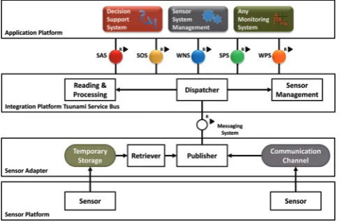
this layer offers a uniform interface for end-user applications, e.g. the decision support system. The implementation follows the paradigm of SOA by using SWE standards and services (Fig. 4). The SWE-based TSB framework accomplishes the integration task by providing a set of services:
– the Sensor Observation Service (SOS) for obtaining sensor observations;
– the Sensor Planning Service (SPS) for tasking the sen-sors;
– the Web Notification Service (WNS) for asynchronous messaging; and
– the Sensor Alert Service (SAS) for sending alerts.
In general, all TSB interfaces were designed as simple as possible by concealing the proprietary data formats and func-tions that are used inside specific sensor systems (Fleischer et al., 2010). However, the advantages of SWE are only ex-posed towards the application side. In contrast, the sensor in-tegration itself cannot be standardised and imposes individ-ual solutions for each sensor type by implementing specific adapters. An even more difficult task of semantic integration takes place inside the TSB within the dispatcher component and its respective plug-ins. This central processing compo-nent analysis processes, stores, and publishes all incoming sensor data. Depending on the received sensor data type, the dispatcher chooses at run time the appropriate process-ing mechanism, provided by “plug-ins”. The content, for-mat, frequency, and size of the incoming sensor data or data streams are in general not restricted, as long as a matching plug-in exists.
4 Decide-and-act
4.1 Graphical User Interface (GUI)
An important component of a TWS is the command and con-trol unit’s GUI concentrating all relevant information offered to human operators for decision making. According to Ham-mitzsch et al. (2012), the GUI has to support operators per-forming their tasks in complex workflows successfully. In critical situations operators have to make proper and reli-able decisions in a very limited time frame. The GUI of the command and control unit therefore has to work reliably and stably, providing the relevant information and functionality timely with the required quality.
The design of the operator’s interface is essential in the development of any TWS to manage hazards effectively and also to facilitate and enhance the decision making processes. The CCUI is a rich client application based on the Eclipse Rich Client Platform (RCP) and the free and open source Geographic Information System (GIS) uDig (Hammitzsch et al., 2010). Wherever possible, the architecture of the CCUI
Fig. 4. High level sensor system integration by Integration Platform
TSB.
component is based on accepted standards. OGC standard compliant services support the access to geo-spatial data, e.g. WMS and WFS are used to compose the situation picture. The simulation system identifying affected areas is integrated via a WPS. The warning message content is structured fol-lowing the CAP.
Based on a typical TWS command and control workflow supporting plausible scenarios, a user interface has been de-signed and implemented based on the modular and dynamic approach of Eclipse RCP with so-called perspectives and views. All functionality associated with a large task in a TWS workflow process is supported by the specific perspec-tive integrating views and editors to cover appropriately de-tails connected to that task (Hammitzsch et al., 2012). In the CCUI four main perspectives, arranged in a workflow, sup-port the operators in their duty to manage a tsunami threat covering objectives of a TWS, including hazard detection and forecast, threat evaluation and alert formulation, and alert dissemination of public safety messages as specified by UNESCO (2011). These requirements are implemented in a workflow including the following main perspectives:
1. The “monitoring perspective” provides the survey of a specific area and contributes an overall situation picture to the operator with geo-spatial information to track run-ning events;
2. The “forecasting perspective” supports the operator in analysing different probable forecasts provided and se-lected by the simulation system based on available sen-sor measurements;
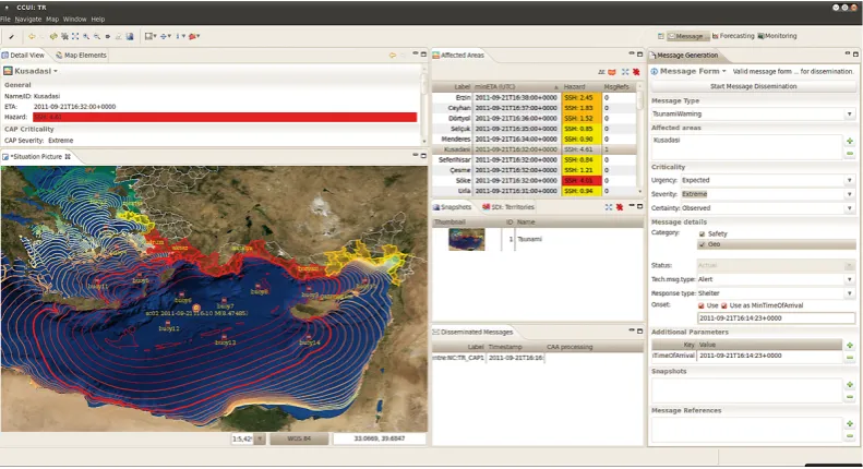
3. The “message composition perspective” (see Fig. 5) en-ables the operator to prepare and send warning mes-sages or system mesmes-sages;
Fig. 5. Message Composition Perspective of CCUI deployed at the Kandilli Observatory and Earthquake Research Institute (KOERI), Turkey
(Ozel et al., 2012).
sent through the different dissemination channels and allows observing all disseminations initiated for specific user groups.
4.2 Simulation system
The simulation system is another core component of a TWS. Its main goal is to provide current situation assessment and tsunami impact forecasting. For this purpose, the simula-tion system relies on available sensor data, on one hand, and numerical models, on the other hand. Modern numeri-cal models provide high accuracy of tsunami simulation and hence have a high prognostic potential. They have been ex-tensively tested and routinely used for many years in all TWS (Babeyko et al., 2010; Behrens et al., 2010). However, tsunami propagation scenarios are very sensitive to the initial conditions. Due to this reason, real-time sensor observations provide absolutely necessary feedback to adjust numerical models in order to provide a reliable tsunami forecast.
In case of a tsunami threat, the simulation system is re-quested to provide a prognostic model of tsunami propaga-tion and impact. This model should be consistent with cur-rent sensor observations. With an increasing number of sen-sor observations, the forecasting becomes more constrained and hence more reliable. Reconciling of numerical models with sensor observations is usually performed by different ways of comparing model predictions for sensors with real sensor data. Reconciling could be done either in fully auto-matic mode as implemented in GITEWS (Steinmetz et al., 2010) or by means of direct interaction of the officer-on-duty as implemented in DEWS.
Traditionally, scenarios of tsunami generation and propa-gation are pre-computed for a large set of initial conditions
and stored in a database of virtual scenarios. This is done due to the fact that computation of tsunami propagation sce-narios is time-consuming and, hence, cannot be done “on-the-fly” in real-time during the early warning process. De-spite its dominant use, the technique of pre-computed sce-narios has several important drawbacks like sampling effects or expensive database management. That is why TRIDEC, in addition to the traditional database approach, also started to implement real-time tsunami simulations for prognostic modelling. Real-time simulations make use of new high per-formance computing techniques such as Graphic Processing Unit (GPU) computing.
5 Downstream
5.1 Generation of customised warning messages
Fig. 6. Overall concept for the information logistics of early warning systems (Lendholt and Hammitzsch, 2011).
control sequences directly sent to automatic devices, e.g. power line switches (actuators).
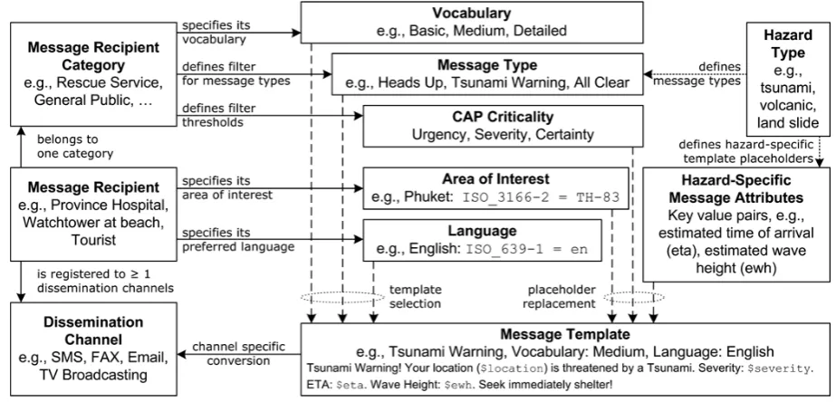
The specification of a generic Information Logistics Com-ponent (ILC) is a main result of the DEWS project. Although similar technological concepts were realised for other, lo-cally bounded projects, they have never been adopted to the realm of ocean-wide tsunami early warning systems. So the key challenge has been the development of a model that would serve in different geographic areas, for heterogeneous message recipient groups, such as rescue services, civil de-fence agencies, and civilians. The model provides message filtering strategies as well as multilingualism and different target group vocabulary.
The warning dissemination is initiated by the decision support component. The concrete generation of customized warning products is executed to another building block of the reference architecture, namely the ILC. The generation of hundreds or even thousands of tailored warning products is a resource-intensive task, which should be handed over to a scalable system. Moreover, the system architecture should be flexible to allow a replacement of one component without replacing the other. Therefore, the decision support applica-tion releases an initial warning message providing all rele-vant information of a present hazard. These so-called haz-ard centric messages (HCM) are taken by the ILC to gener-ate user centric messages (UCM) customized to the needs of each identified message recipient. These warning products must be converted into dissemination channel-specific for-mats and protocols. The required conversion of UCMs into channel-specific products is based on the respective chan-nel characteristics and is managed by the Information Dis-semination Component (IDC). IDC channel adaptors convert
messages into formats suited for respective dissemination channels (Esbr´ı et al., 2012).
Standards of OASIS are used to communicate warning messages by means of CAP and EDXL-DE between these components. While CAP is used to encode tsunami warn-ings, alerts and other official bulletins, EDXL-DE serves as a routing envelope with addressing information. The back-channel, the feedback information from ILC and IDC to the decision support application, is also realised by using EDXL-DE messages with domain-specific payload informing about the number of generated, disseminated, and processed mes-sages.
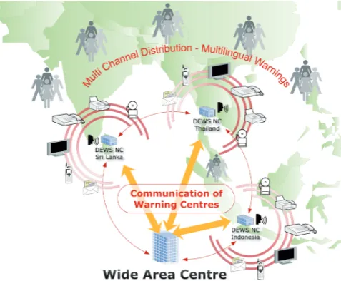
Fig. 7. Centre-to-centre communication in a system-of-systems.
5.2 Information logistics in centre-to-centre communication
A main objective of the IOC Tsunami Programme is the in-tegration of national TWS towards ocean-wide networks of early warning systems to ensure information exchange dur-ing tsunami events. The centre-to-centre communication in a system-of-systems requires a new generation of interopera-ble message products introduced by Lendholt et al. (2012). The information flow in a system-of-systems setup between warning centres combines up- and downstream information flow of a standalone system (Fig. 7). Therefore, message ex-change in crisis situations relies on both
– sensor measurements such as sea level data and earth-quake measurements; however, only pre-processed and verified data will be exchanged to ensure reliability and confidence among the different centres. As discussed, the OGC SWE standards are best suited to communi-cate sensor data and observations.
– warning products such as tsunami bulletins: bulletins are disseminated by authorities in the context of inter-national warning networks and serve other warning cen-tres in decision processes. As discussed, CAP serves all needs to transport both human readable messages as well as structured information for (automatic) post-processing by other centres.
For setting up a network of TWS, the challenge is to com-bine both protocols into a common message format. This is realized by using EDXL-DE as container format for both message types. Special attention must be drawn to the spa-tial reference scheme used in tsunami bulletins. In national systems the coastal forecast points (CFP) are used by simu-lations as reference points for the wave propagation. These
points are mapped to administrative units or coastal fore-cast zones (CFZ) to establish an adequate and well-known spatial reference for warning dissemination. However, in the international context such proprietary solutions are not suit-able. Therefore, Intergovernmental Coordination Group for the Indian Ocean Tsunami Warning and Mitigation Sys-tem (ICG/IOTWS) has introduced a standardised set of CFZs for the Indian Ocean to ensure interoperability among inter-linked warning centres. The DEWS project has implemented a prototype for centre-to-centre communication based on these precedent-setting concepts (further details in Lendholt et al., 2012).
6 Future challenges
6.1 Current status
In the last decade tsunami warning systems have shown a significant development from far-field to near-field monitor-ing systems. With respect to architecture far-field monitormonitor-ing systems are built upon seismic systems responsible for earth-quake localisation. This input is used by simulation tools for predicting the tsunami wave propagation in the ocean in order to calculate available time frames for initialising ap-propriate reactions. For GITEWS and the specific geological setting for Indonesia, near-field warning systems with dras-tically reduced time warning activities had to be addressed. These increased performance requirements and the integra-tion of addiintegra-tional sensor system resulted in more complex warning system architectures. The design of a sensor integra-tion platform adoptable for addiintegra-tional types of sensors was an important step in the GITEWS project. These TSB upstream services were complemented in the DEWS project, and spe-cific components for the downstream information manage-ment have been added. As a result, the GITEWS TSB has been extended to a service platform covering the complete range of services supporting the upstream and downstream information flows and as well as basic decision support pro-cesses.
6.2 Unconventional sensors for rapid situation assessment
In addition to “conventional” sensor systems, such as in-situ sensor networks providing time series measurements from seismic sensors, tide gauges and deep water buoys, in recent years vast amounts of Web 2.0 content has become avail-able, such as Twitter messages, YouTube videos and RSS feeds (Middleton et al., 2012). These Web 2.0 “unconven-tional” sensors provide rapid in-situ crowd-sourced measure-ment actually experiencing the crisis event, e.g. using mo-bile devices, albeit with variable quality and a high noise-to-signal ratio. The application of unconventional sensors for wide area monitoring of coastal areas based on the exploita-tion of crowdsourcing approaches and social media or local webcams is a very promising approach for TWS.
The main goal of these new types of sensors is to acquire additional information on tsunami wave arrival and the ef-fects on the coastal areas. In this sense, unconventional sen-sors operate like “light-weight sensen-sors” providing simulation units and decision makers with data on the wave propagation. The expected data quality of this type of sensors is lower compared to traditional sensor systems. However, the poten-tially huge amounts of covered coastal locations, especially in high-populated areas such as Mediterranean, will compen-sate these quality deficits. Additionally, the consequent dis-tribution of high numbers of low-cost sensor systems includ-ing accelerometers will become of increasinclud-ing importance, e.g. for deriving early damage estimations in crisis situations. 6.3 Test strategies in a system-of-systems environment
Tsunamis are rare but potentially very disastrous events of-ten affecting many regions around respective ocean basins. According to the results of the communication test exercise NEAMTWS-ECTE1 (2011), all warning system elements must keep a high level of readiness so as to be able to act effi-ciently and effectively during fast-onset and rapidly-evolving natural disasters like tsunamis. Regular tests of TWSs are conducted in other regions as well, e.g. in the Indian Ocean (IOWave11, 2011) and the Pacific Ocean (PacificWave11, 2011). To maintain a high state of operational readiness and especially for infrequent events such as tsunamis, tsunami watch/warning centres and emergency agencies must regu-larly practice their response procedures.
Additionally, a complementary set of tests has to be de-signed and implemented focussing on the technological per-formance of the warning system and the warning system components. All system parts have to work properly to guar-anty the availability of the system in case of a crisis. This includes sensor systems and dissemination channels and also other system resources, e.g. compute servers and storage sys-tems as well as telecommunication lines. The performance of all components has to be validated against defined criteria. Especially in a system-of-system environment, the concepts
of IT Service Management (e.g. OGC/ITIL, 2010) and the negotiation of and the compliance with Service Level Agree-ments (SLA) have to be considered carefully. Tests of the complete system have to be executed on a regular basis or in case of need, e.g. after new software components or new sensor systems have been deployed.
All tests will depend on and will be conducted with sim-ulations i.e. computed data sets describing virtual tsunami scenarios. For these reasons the sound understanding of tsunami generation and propagation derived from historic events plays a key role for a comprehensive set of system tests. Test scenarios do not only have to cover simple test cases, but also complex settings. Tests and embedding traing activities have to take place on all levels of warntraing in-frastructures: regionally, nationally, and locally.
6.4 Event-driven architecture
The requirements for TWSs outlined above will have a strong influence on the design, implementation, deployment, and successful operation of future warning systems. System-of-systems approaches have been agreed on for the concrete im-plementation of large-scale infrastructures, e.g. the Global Earth Observation System of Systems initiated and organ-ised by the Group on Earth Observation (GEOSS, 2011). In the context of TWS special attention has to be paid to per-formance and robustness criteria safeguarding the agile re-action and flexible behaviour of this system-of-systems in crisis situations. A technological core objective therefore is the design and implementation of a robust and scalable ser-vice infrastructure supporting the integration and utilisation of existing resources as well as the management of very large volumes of data.
The intended evolution of today’s TWSs to regional or even global system-of-systems will benefit considerably from new architectural patterns for information systems that have been designed for event-driven systems. Events result from changes or developments in the respective system en-vironment. Event-driven architectures (EDA; Taylor et al., 2009) are the new paradigm for the design of this type of system. EDA are the specific application of SOA concepts in areas where independent, very loosely coupled systems have to cooperate and synchronise their activities in order to re-act properly on complex events, e.g. a large-scale regional tsunami. Key concepts and essential methods for CEP have been developed and published by Luckham (2002).
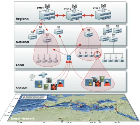
Fig. 8. Architectural levels of a regional tsunami warning system.
processes and facilitates information sharing between orga-nizations. The consequent application of workflows and de-cision tables for the organisation of processes in this level provides a considerable increase in the flexibility to adopt the warning system to specific requirements (Riedel et al., 2012).
6.5 From system-of-systems to multi-hazard warning infrastructure
Important requirements for the design of the TRIDEC frame-work are currently being developed in the UNESCO/IOC framework. The specification process of NEAMTWS (and its general architecture) is on-going (ICG/NEAMTWS, 2009, 2011; see also TOWS-WG, 2011 and UNESCO, 2011). The main structural elements and components of the architec-ture have been identified including their basic functionality, standard operational procedures (SOP), as well as interac-tion patterns between nainterac-tional and regional warning centres. The NEAM region consists of sub-basins with individual conditions and challenges for tsunami warning. For each of these sub-basins, specific RTSPs/RTWCs (RTSP: Regional Tsunami Advisory Service Provider according to TOWS-WG, 2011; RTWC: Regional Tsunami Watch Centre accord-ing to ICG/NEAMTWS, 2011) could implement defined re-sponsibilities by working as a hub and message broker for several NTWCs, respectively.
The NTWCs are responsible for the management of tsunami crises on a national level. The NTWCs together with the National Tsunami Focal Points (NTFP) operate within their national legal framework and provide warn-ings, watches, and advisories to their citizens, and public and private agencies. These warnings are based either on the NTWC’s own analysis of the situation, on the advisory
messages received from TWPs or on a combination of all (ICG/NEAMTWS, 2011). As a result a future tsunami warn-ing infrastructure in the NEAM region will be a system-of-systems with a complex multi-layer architecture (Fig. 8).
The objectives of UNESCO/IOC even go beyond the perspectives summarised above. The Working Group on Tsunamis and Other Hazards Related to Sea-Level Warn-ing and Mitigation Systems (TOWS-WG, 2011) is develop-ing terms of reference for a global early warndevelop-ing infrastruc-ture not only for tsunamis, but also expanding the existing infrastructures to other sea related hazards, and in coopera-tion with organizacoopera-tions such as Group of Earth Observacoopera-tion (GEO) and GEOSS to implement a global multi-hazard in-frastructure (summarised in Lauterjung et al., 2010b).
Appendix A
Acronyms and abbreviations
CAP – Common Alerting Protocol
CCUI – Command and Control User Interface CEP – Complex Event Processing
DEWS – Distant Early Warning System Eclipse RCP – Eclipse Rich Client Platform EDA – Event-Driven Architecture
EDXL-DE – Emergency Data Exchange Language – Distribution Element
ESB – Enterprise Service Bus GEO – Group of Earth Observation
GEOSS – Earth Observation System of Systems GIS – Geographic Information System
GITEWS – German Indonesian Tsunami Early Warning System
GPU – Graphic Processing Unit GUI – Graphical User Interface HCM – Hazard Centric Messages
ICT – Information and Communications Technology IDC – Information Dissemination Component ILC – Information Logistics Component
ICG/IOTWS – Intergovernmental Coordination Group for the Indian Ocean Tsunami Warning and Mitigation System
ICG/NEAMTWS – Intergovernmental Coordination Group for the Tsunami Early Warning and Mitigation System for the North-eastern Atlantic, the Mediterranean and Connected Seas
IOC – Intergovernmental Oceanographic Commission of UNESCO
OASIS – Organization for the Advancement of Structured Information Standards
OGC – Open Geospatial Consortium
OGC/ITIL – Office of Government Commerce/IT Infrastructure Library
SAS – Sensor Alert Service SLA – Service Level Agreements SOA – Service Oriented Architecture SOS – Sensor Observation Service SPS – Sensor Planning Service SWE – Sensor Web Enablement
TRIDEC – Collaborative, Complex and Critical Decision-Support in Evolving Crises
TSB – Tsunami Service Bus TWS – Tsunami Warning System UCM – User Centric Messages
uDig – user-friendly Desktip Internet GIS
UNESCO – United Nations Educational Scientific and Cultural Organisation
USIOTWS – US Indian Ocean Tsunami Warning System WMS – Web Mapping Service
WFS – Web Feature Service WNS – Web Notification Service WPS – Web Processing Service
Acknowledgements. This article is based on the work of the authors
the German Indonesian Tsunami Early Warning System (GITEWS) funded by the German Federal Ministry of Education and Research BMBF and in the European FP6 project Distant Early Warning System (DEWS). These developments are continued by the FP7 project Collaborative, Complex, and Critical Decision-support in Evolving Crises (TRIDEC) funded under the European Union’s FP7. TRIDEC started in September 2010 and will be concluded in August 2013.
The service charges for this open access publication have been covered by a Research Centre of the Helmholtz Association.
Edited by: S. Tinti
Reviewed by: S. Kumar and another anonymous referee
References
Babeyko, A. Y., Hoechner, A., and Sobolev, S. V.: Source model-ing and inversion with near real-time GPS: a GITEWS perspec-tive for Indonesia, Nat. Hazards Earth Syst. Sci., 10, 1617–1627, doi:10.5194/nhess-10-1617-2010, 2010.
Behrens, J., Androsov, A., Babeyko, A. Y., Harig, S., Klaschka, F., and Mentrup, L.: A new multi-sensor approach to simulation as-sisted tsunami early warning, Nat. Hazards Earth Syst. Sci., 10, 1085–1100, doi:10.5194/nhess-10-1085-2010, 2010.
Chappell, D. A.: Enterprise Service Bus, O’Reilly, 2004.
Erl, T.: SOA, Entwurfsprinzipien f¨ur serviceorientierte Architektur, M¨unchen, Addison-Wesley, 2008.
Esbr´ı, M. A., Hammitzsch, M., and Lendholt, M.: A hazard-independent approach for the standardised multi-channel dissem-ination of warning messages, in: European Geosciences Union (EGU) General Assembly 2012, Vienna, Austria, 22–27 April 2012, Geophys. Res. Abstr., EGU2012-10014, EGU General As-sembly 2012, Vienna, Austria, 2012.
Falck, C., Ramatschi, M., Subarya, C., Bartsch, M., Merx, A., Hoe-berechts, J., and Schmidt, G.: Near real-time GPS applications for tsunami early warning systems, Nat. Hazards Earth Syst. Sci., 10, 181–189, doi:10.5194/nhess-10-181-2010, 2010.
Fleischer, J., H¨aner, R., Herrnkind, S., Kloth, A., Kriegel, U., Schwarting, H., and W¨achter, J.: An integration platform for heterogeneous sensor systems in GITEWS – Tsunami Ser-vice Bus, Nat. Hazards Earth Syst. Sci., 10, 1239–1252, doi:10.5194/nhess-10-1239-2010, 2010.
GEOSS: Group on Earth Observation, GEO 2012-2015 Work Plan, available at: http://www.earthobservations.org/documents/ work%20plan/GEO%202012-2015%20Work%20Plan Rev1. pdf (last access: 6 May 2012), 2011.
H¨aner, R. and Kriegel, U.: From GITEWS to InaTEWS: An Archi-tectural Blue Print, Potsdam, 2008.
Hanka, W., Saul, J., Weber, B., Becker, J., Harjadi, P., Fauzi, and GITEWS Seismology Group: Real-time earthquake moni-toring for tsunami warning in the Indian Ocean and beyond, Nat. Hazards Earth Syst. Sci., 10, 2611–2622, doi:10.5194/nhess-10-2611-2010, 2010.
Hammitzsch, M. and Lendholt, M.: Evolving an infor-mation logistics database for geospatial early warn-ing systems, Geomatics, Nat. Hazards Risk, 2, 95–109, doi:10.1080/19475705.2011.563448.2, 2011.
Hammitzsch, M., Lendholt, M., and W¨achter, J.: Distant Early Warning System for Tsunamis – A wide-area and multi-hazard approach, in: European Geosciences Union (EGU) General As-sembly 2010, Vienna, Austria, 02–07 May 2010, Geophys. Res. Abstr., EGU2010-4496, EGU General Assembly 2010, Vienna, Austria, 2010.
Hammitzsch, M., Lendholt, M., and Esbr´ı, M. ´A.: User in-terface prototype for geospatial early warning systems – a tsunami showcase, Nat. Hazards Earth Syst. Sci., 12, 555–573, doi:10.5194/nhess-12-555-2012, 2012.
ICG/NEAMTWS: Tsunami Early Warning and Mitigation Sys-tem in the North Eastern Atlantic, the Mediterranean and Con-nected Seas, NEAMTWS Implementation Plan, Version 3.4, In-tergovernmental Oceanographic Commission Technical Series 73, 2009.
ICG/NEAMTWS: Interim Operational Users Guide for the Tsunami Early Warning and Mitigation System in the North-eastern Atlantic, the Mediterranean and Connected Seas (NEAMTWS), Version 1.9, 2011.
IOWave11: Indian Ocean Tsunami Warning and Mitigation System (IOTWS), Exercise Indian Ocean Wave 2011 (IOWave11) An Indian Ocean-wide Tsunami Warning and Communication Ex-ercise, IOC Technical Series No. 99, UNESCO, 2011.
Josuttis, N.: SOA in der Praxis, Heidelberg, dpunkt.verlag, 2008. Kamigaichi, O.: Tsunami forecasting and warning, in:
Encyclope-dia of Complexity and Systems Science, edited by: Meyers, R. A., Springer, 9592–9618, 2009.
Lauterjung, J., M¨unch, U., and Rudloff, A.: The challenge of in-stalling a tsunami early warning system in the vicinity of the Sunda Arc, Indonesia, Nat. Hazards Earth Syst. Sci., 10, 641– 646, doi:10.5194/nhess-10-641-2010, 2010a.
doi:10.5194/nhess-10-2623-2010, 2010b.
Lendholt, M. and Hammitzsch, M.: Generic Information Logistics for Early Warning Systems, Proceedings of the 8th International ISCRAM Conference, Lisbon, 2011.
Lendholt, M., Esbr´ı, M. ´A., and Hammitzsch, M.: Integrating na-tional tsunami early warning systems – towards ocean-wide system-of-systems networks Proceedings of the 9th International ISCRAM Conference, Vancouver, 2012.
Luckham, D. C.: The Power of Events, an Introduction to Complex Event Processing in Distributed Enterprise Systems, Addison-Wesley, Reading, 2002.
Middleton, S. E., Sabeur, Z. A., L¨owe, P., Hammitzsch, M., Tavakoli, S., and Poslad, S.: Multi-disciplinary approaches to in-telligently sharing large-volumes of real-time sensor data during natural disasters, Data Science Journal, in press, 2012.
Moßgraber, J., Middleton, S., Hammitzsch, M., and S. Poslad, S.: A Distributed Architecture for Tsunami Early Warning and Col-laborative Decision-support in Crises, in: European Geosciences Union (EGU) General Assembly 2012, Vienna, Austria, 22–27 April 2012, Geophys. Res. Abstr., EGU2012-8040-2, EGU Gen-eral Assembly 2012, Vienna, Austria, 2012.
NEAMTWS-ECTE1: Tsunami Early Warning and Mitigation Sys-tem in the North-Eastern Atlantic, the Mediterranean and connected seas, First Enlarged Communication Test Exercise (ECTE1), Exercise Manual and Evaluation Report, IOC Tech-nical Series No 98, UNESCO/IOC, 2011.
OGC: OGC® Standards and Supporting Documents, available at: http://www.opengeospatial.org/standards, last access: 6 May 2012.
OGC/ITIL: The Official Introduction to the ITIL® Service Lifecy-cle, TSO, 2010.
Ozel, N. M., Necmioglu, O., Yalciner, A. C., Kalafat, D., Yilmazer, M., Comoglu, M., Sanli, U., Gurbuz, C., and Erdik, M.: Tsunami Early Warning in the Eastern Mediterranean, Aegean and Black Sea, in: The 22nd International Offshore and Polar Engineering Conference, Rhodes (Rodos), Greece, 17–22 June 2012, 2012. PacificWave11: Exercise Pacific Wave 11, A Pacific-wide Tsunami
Warning and Communication Exercise, 9–10 November 2011, Vol. 1, IOC Technical Series No 97., UNESCO/IOC, 2011.
Riedel, F., Chaves, F., and Zeiner, H.: Flexible Early Warning Sys-tems with Workflows and Decision Tables, in: European Geo-sciences Union (EGU) General Assembly 2012, Vienna, Aus-tria, 22–27 April 2012, Geophys. Res. Abstr., EGU2012-7735-1, EGU General Assembly 2012, Vienna, Austria, 2012.
Sch¨one, T., Pandoe, W., Mudita, I., Roemer, S., Illigner, J., Zech, C., and Galas, R.: GPS water level measurements for Indonesia’s Tsunami Early Warning System, Nat. Hazards Earth Syst. Sci., 11, 741–749, doi:10.5194/nhess-11-741-2011, 2011a.
Sch¨one, T., Illigner, J., Manurung, P., Subarya, C., Khafid, Zech, C., and Galas, R.: GPS-controlled tide gauges in Indonesia – a Ger-man contribution to Indonesia’s Tsunami Early Warning System, Nat. Hazards Earth Syst. Sci., 11, 731–740, doi:10.5194/nhess-11-731-2011, 2011b.
Steinmetz, T., Raape, U., Teßmann, S., Strobl, C., Friedemann, M., Kukofka, T., Riedlinger, T., Mikusch, E., and Dech, S.: Tsunami early warning and decision support, Nat. Hazards Earth Syst. Sci., 10, 1839–1850, doi:10.5194/nhess-10-1839-2010, 2010. Taylor, H., Yochem, A., Phillips, L., and Martinez, F.:
Event-Driven Architecture: How SOA Enables the Real-Time Enter-prise, Addison-Wesley, 2009.
TOWS-WG: Working Group on Tsunamis and Other Hazards Re-lated to Sea-Level Warning and Mitigation Systems (TOWS-WG), Fourth Meeting, Paris, France 20–21 March, Intergovern-mental Oceanographic Commission Reports of Meetings of Ex-perts and Equivalent Bodies, 2011.
UNESCO: Indian Ocean Tsunami Warning and Mitigation System IOTWS. Implementation Plan Eighth Session of the Intergovern-mental Coordination Group for the Indian Ocean Tsunami Warn-ing and Mitigation System (ICG/IOTWS-VIII), Melbourne, Aus-tralia, 3–6 May 2011, IOC Technical Series No. 71. (Revision 4), 2011.
USIOTWS: Tsunami Warning Center Reference Guide, US Indian Ocean Tsunami Warning System Program, 2007.