A web-gis geo-data catalogue
application for analysis and comparison of data availability
and information required for land planning and
management
Giovanni Borga
Department of Urban and Regional Planning IUAV University of Venice, [email protected]
Phone number: +39-347-6492111
Keywords:
web-gis; geo-CMS; geo-data catalogue; online catalogue; metadata; geographic information catalogue; information demand; geo-data supply
Abstract
The application presented is part of the integrated research “New Technologies, Land and Environmental Information” that University IUAV of Venice is carrying out. It is a web-based application using DBMS and GIS technologies, developed with the aim of :1) storing, managing and exploring geo-data provided by public administrations and private companies; 2) testing several models of representing data availability compared with information needed for land planning and management. Probably the implementation of the European thesaurus GEMET is one the most interesting items of the study. GEMET has the important function of contents semantic classification system with which is possible to evaluate how geo-data available meets information needed; GEMET contains a group of keywords with internal hierarchies and classifications that makes possible semantic comparisons and put in evidence the gap between available data and needed information. All information collected within research activities are stored in three databases mutually connected by an integrated structure which is the main data provider for the web-gis application. The web based interface offers two different ways to explore integrated database contents. The first way allows user to select a specific activity in the field of land management, showing the list of the needed geo-information and geo-data availability; the second way directly gives the “view” of data available in a specific geographical area.
Project, databases and web-gis application
About land planning and management
The complexity of the issues related to the protection and management of the environment involves a need for increasing amounts of knowledge and data in support of planning processes. Due to the great than ever
complexity of urban phenomena and planning processes it’s more important to understand the relationship between data supply available from new technology sources and public administration archives and the demand for information from urban policy-makers and managers.
New technologies offers extraordinary opportunities for a joint public and private sector effort to improve our understanding of territorial and environmental states and problems.
However, at least as regards Italy, environmental and territorial information systems suffer both from cultural underdevelopment and a lack of public initiative. Political and cultural effort is needed to promote action designed to provide better understanding of the environment, with a view to ensuring its protection and enhancement
The most important aim of the project is to explore techniques and technologies useful to perform permanent monitoring of data supply and information demand but it also provide an overview of the various institutions that work in the field of environmental and urban information management with a view to proposing the creation of a new institutional arrangement whereby a National Agency and series of Regional Agencies would be responsible for setting up an integrated system for the collection, processing and dissemination of environmental and territorial information.
To this end, a prototype application has been created for testing such a system with information collected about a limited - specific geographical area.
The database system for collation of information supply and demand
The permanent monitoring of the activities carried out by operators in charge of territorial administration and protection of the environment, proposed as one of the functions of the Regional Agencies, therefore provides material to three different databases:
• the supply of data coming from technological equipment (“Sensors DB”);
• the supply of data supplied by institutional activities (“GeoData DB”);
• the demand for territorial-environmental information to carry out the tasks of territorial administration
(“Info Demand DB”).
A fourth database contains the elements that enable the integration of the first three. Altogether they make up what we have called the “integrated database”, that is the database that constitutes the main ‘data provider’ for the application to consult the databases. Before giving a detailed description of the interface and functionality of the access application, we must expand on the techniques used to integrate the different databases and briefly introduce the use of the General European Multilingual Thesaurus, GEMET, which is the key element of the integration. The use of the DBMS technology to monitor, record and relate the supply and demand of territorial information presupposes the design of a logical model to identify, among other things, a semantic mediator that will allow demand records to be matched against those of the supply. While it is evident that a normal textual description of information contents does not allow analysis of “matching” between demand and offer, it is not so easy to find another way to describe/present these contents. On reflection, the best solution appeared to be the use of a list of “keywords”, three definitions of which were considered:
• a dynamic list, auto-expanded through free input by the user; • a static or dynamic list compiled or expanded by an administrator;
• a static list taken from other disciplinary contexts.
At this point, analysis of the GEMET proved interesting, in particular its rich internal system of hierarchies and semantic classifications. This led to the third of the above options being chosen and the GEMET was duly included in the database. GEMET’s main component is the list of descriptors in which elements are explained briefly and translated into various languages. The descriptors are classified by means of two different systems:
• the first type involves “assembling” groups and macro-groups (so the relation is one to many);
• the second type involves direct “assignment” to one or more topics in a list of forty terms (so the relation is many to many).
These two systems “coexist without interfering” with each other and therefore constitute a double system of classification. In addition to being classified, the descriptors are reciprocally related, again with a double system:
major elements “Dataset” and “Agencies/Companies”: the former is a catalogue of all the information resources registered; the latter is a record of the public/private subjects connected for various reasons to these resources. This database also includes a specific relationship table containing the multiplicity of links between a database and all the descriptors that provide a brief explanation of its information contents. Finally, the “Info Demand DB” is used to register the information demand and contains the principal elements “Activities”, “Acts/Rules”, “Agencies/Companies/Planners”; respectively, these represent:
• the territorial administration actions carried out by agencies; • the regulatory provisions that form the reference framework;
• the typologies of the subjects involved in the performance of the above “Activities”.
Another element within the “Info Demand DB” – “Demand” – connects the other three and makes it possible to deal with the demand extrapolated from the regulatory framework of reference and with that expressed directly by public authorities working in the field of territorial governance and management. Consequently the results are associated to one or more descriptors, which characterize their information contents and enable them to be related with the supply. Technically, the relation between demand and supply is established when “joints” linking the GEMET descriptors are inserted into the database and by executing the queries that provide the synoptic framework of the relation between supply and demand. It is interesting to note that the GEMET system of hierarchical relations can be exploited to explore “indirect” as well as “direct” matches. For example, a “direct match” is one that connects a database concerning, say, landslide phenomena with a demand for information about areas that are subject to landslides, using the descriptor “landslide”. By contrast, if we consider a specific sensor used for meteorological investigations and forecasts, associated with the descriptor “meteorological phenomena”, and a demand for information about wind speeds associated with the descriptor “wind”, the two elements can still be linked, in this case through an “indirect match”, in that the descriptors “meteorological phenomena” and “wind” are in turn linked to each other by a hierarchical relationship inside GEMET. If we consider the complexity of the hierarchy of descriptors it is easy to imagine that exploration of the hierarchy will produce many more matches between supply and demand than would be possible through “direct matches”. It is equally clear that the higher the number of connections matching supply and demand descriptors the less significant the match will be.
The integrated database therefore provides an instrument capable of comparing the information demand with the available data of relating the monitoring activity and the high or poor quality of the information related with territorial/environmental data. For this reason, inside the database, each element of the demand requires an indicator which is based on the amount of resources connected to the descriptors matched and weighted according to the importance attributable to each individual match.
The Application to consult the integrated database
The application providing access to the integrated database has been designed with two necessities in mind:
• to enable the contents to be consulted by a network of operators and stakeholders;
• to supply an innovative technological instrument for the activities of monitoring and support to
operators in the field provided by an institutional authority for territorial/environmental information. To attain these objectives, the web is the natural choice as the platform for primary development of the application and for the conveyance of data. In effect, the first point constitutes the “front-end” of the database, while the second is the “back-end” with which the system administrator can record the permanent monitoring activity. The administrator will also use the “back-end“ functions to develop a parallel activity of devising “packages” that combine data from sensors with information layers to obtain “added information value” and orientates them to specific segments of the demand.
While the way the back-end of the system functions is substantially analogous that of a classic CMS, the public interface features a number of distinctive characteristics.
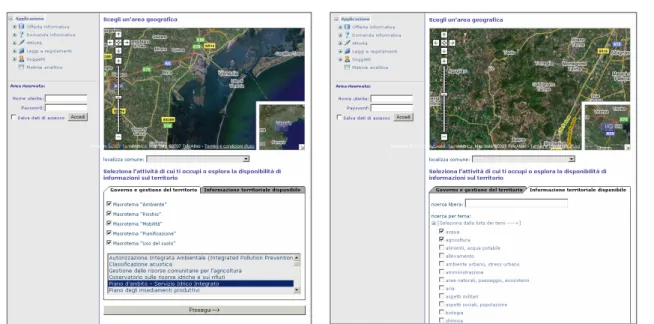
Fig. 1: the prototype interface and the two approaches for the consultation of the integrated database The navigation system introduces a unique initial access phase that follows two distinct routes: the first invites the user to choose one of the territorial government activities in the database and then givers access to the analytical phase of matching information supply and demand; the second allows the user to explore all data availability, regardless of the use that can be made of it; for both approaches the user may choose a geographical area of reference. After the initial choice of activity and geographical area, the user choosing the analytical demand/supply route enters a page containing more customizable elements; the upper part of the page shows the list of the demand items connected with the activity chosen, each with a short description, and a score that indicates how much the supply repository offers in response to each single item. The score indicator can be increased to allow the exploration to focus on the detail of a single semantic descriptor, visualizing the related information resources.
Amongst the more interesting tools assisting the user to explore information supply is a navigable map with selectable content with which the user can visualize one or more supply layers superimposed on a generic two-dimensional cartographic base and the preview of the data on Google Earth through which it is also possible to visualize data in three dimensions. In both the lists of demand and supply it is possible to highlight the matched items, i.e. to indicate which resources satisfy a given demand and which demands can a given resource contribute a response to.
Unlike the first approach, the second leads directly to analysis of the available resources for the chosen territorial area irrespective of the demand in question. The research tools include a first filter through which certain topics can be removed from the complete list inherited from the GEMET dictionary in order to focus the research on those which are of interest. The next page shows the same interface used for the first approach as regards supply; above this section, a series of mutually integrable criteria allows the user to set up custom filters and thereby reduce a potentially long list of information layers; searches can be conducted on the basis of words contained in titles or descriptions and the database can be filtered by descriptor, minimum and maximum scale, date of updating and data type.
Conclusions
The project have so far led to the creation of a first prototype and to its testing inside a study area.
Future targets, in the light of considerations prompted by the test phase, involve passing from the prototype phase of the system to a more operational and consolidated phase.
It is planned in particular:
• to create a simplified interface for access to the information (forms, metadata, information on costs, etc.)
• to focus on automatic methods of updating data, as regards both supply (“Sensors DB” and “GeoData
DB”) and demand (“Info Demand DB”).
• to start a debate about the institution of national and regional agencies.
Reference list
Books:
Lagomarsino L. & Ghiara H. & Cristoforetti G. 2002, Riqualificazione urbana e territoriale ed informazione geografica, Firenze, Alinea.
CNIPA: Comitato Nazionale per l’Informatica nella Pubblica Amministrazione (presso la Presidenza del Consiglio dei Ministri) 2006. Repertorio Nazionale dei Dati Territoriali - Linee guida per l’applicazione dello Standard ISO 19115 Geographic Information – Metadata
Consorzio di Bonifica Delta Po Adige. 1991. Relazione di sintesi del Piano Generale di Bonifica e di Tutela del Territorio Rurale
CNR (Consiglio Nazionale delle Ricerche) 2002, Environmental Application Reference Thesaurus – Thesaurus di Riferimento per Applicazioni Ambientali – Edizione bilingue GEMET-compatibile per il Ministero dell’Ambiente e della Tutela del Territorio, Edizioni Publications
Atzeni, P. & Ceri, S. & Fraternali, P.& Paraboschi, S. & Torlone, R. 2002, Modelli e linguaggi di interrogazione. Milano: McGraw-Hill-Italia.
Atzeni, P. & Ceri, S. & Paraboschi, S. & Torlone, R. 2003. Basi di Dati, Architetture e linee di evoluzione. Milano: McGraw-Hill-Italia
Van Der Lans R.F. 1990. Introduzione a SQL, Milano, Addison- Wesley
Cammelli, M.& Guerra, M. P. 2002. Informazione e funzione amministrativa. Rimini: Maggioli Editore
Carbone, L. & Caringella, F. & Romano, F. 2001. Il nuovo volto della Pubblica Amministrazione. Napoli: Edizioni Giuridiche Simone
Cassano, G.& Giurdanella, C. 2005. Il codice della pubblica amministrazione digitale: Commentario al d. lgs. n. 82 del 7 marzo 2005. Milano: Edizioni Giuffrè
Cavalieri, P. & Venturini, F. 2004. Documenti e dati pubblicati sul web. Guida all'informazione di fonte pubblica in rete. Bologna: Edizioni Mulino
Fraden, J. 1999. Handbook of Modern sensors, Physics, Designs, and Applications. New York: American Institute of Physics, American Institute of Physics
Mather ,P. M. 2004. Computer Processing of Remotely- Sensed Images- Third Edition. Chichester: John Wiley & Sons
Merloni, F. 2002.L'informazione delle pubbliche amministrazioni. Rimini: Maggioli Editore
Skidmore, A.& Prins, H. 2002. Environmental Modelling with Gis and Remote Sensing. London: Taylor and Francis
Directive 2007/2/EC of the European Parliament and of the Council of 14 March 2007 establishing an Infrastructure for Spatial Information in the European Community (INSPIRE)
Journal Articles:
Liguori F. & Rossi M. & Corongiu M. 2005. La realizzazione del database topografico secondo le specifiche intesaGIS - Stato dell’arte emerso dagli incontri con Regioni ed Enti Locali, problemi aperti e primi approfondimenti , attività svolte su incarico del C.I. e come contributo del SGR della Regione Toscana
Guazzetti F. & Rao S. Specifiche intesaGIS nella realizzazione di DB topografici a cura di aggregazioni di piccoli comuni: prototipo sull’unione collina torinese.
Web sites:
EEA: European Environmental Agency. Official website [Online]. Available: http://www.eea.europa.eu/ EEA: European Environmental Agency. EIONET: European Environment Information and Observation Network [Online]. Available: http://www.eionet.europa.eu
EEA: European Environmental Agency. GEMET: GEneral Multilingual Environmental Thesaurus [Online]. Available: http://www.eionet.europa.eu/gemet
Intesa stato – regioni - enti locali per la realizzazione dei sistemi informativi geografici. Official website [Online]. Available: http://www.intesagis.it
INSPIRE – Infrastructure for Spatial Information in Europe. Official website [Online]. Available: http://www.ec-gis.org/inspire
CNIPA – Comitato Nazionale per l’Informatica nella Pubblica Amministrazione. Official website [Online]. Available: http://www.cnipa.gov.it
EKOLab. EARTh Thesaurus. [Online]. Available: http://uta.iia.cnr.it/earth.htm
CNR (Consiglio Nazionale delle Ricerche). EARTh Thesaurus [Online]. Available: http://www.t-reks.cnr.it/docs/EARTh_pdf/Vol_00.pdf
Federal Geographic Data Committee. Official website [Online]. Available: http://www.fgdc.gov/
CEN – European Commitee for Standardization. Official website [Online]. Available: http://www.cenorm.be/ ISO – International Organization for Standardization. Official website [Online]. Available: http://www.iso.org/ Provincia di Siena. Metadata del SIT [Online]. Available: http://geoserver.etelnet.it/metadata
Provincia di Treviso. Metadata [Online]. Available: http://siti.provincia.treviso.it/metadata AATO Laguna di Venezia. Official website [Online]. Available: http://www.atolagunadivenezia.it