DESIGN CONSIDERATIONS FOR CLUSTERING
LOCALIZATION TECHNIQUE IN AN INDOOR WIRELESS
NETWORK
1SITI ZAKIAH HASAN, 2ROSDIADEE NORDIN
1,2Department of Electrical, Electronics, and Systems Engineering, Faculty of Engineering & Built
Environment, Universiti Kebangsaan Malaysia, Bangi 43600, Selangor, MALAYSIA
E-mail: [email protected], [email protected]
ABSTRACT
Indoor positioning technique, also known as localization is an application that can benefit from the Wireless Local Area Network (WLAN) infrastructure and WLAN enabled devices. This paper discusses implementation of an indoor wireless localization network by using the existing WLAN infrastructure based on a novel clustering technique. Design criteria and parameters involved to form a cluster group has been defined and presented. The preliminary results from this study indicates the proposed clustering technique able to perform indoor localization, whereby total of 17 cluster groups have been generated from the 82 anchor points in an indoor area. Several proposal enhancements also presented in order to enhance the accuracy and improve the selection criteria of the clustering method.
Keywords: Cluster, Indoor Localization, Positioning Technique, RSS, WiFi, WLAN
1. INTRODUCTION
The indoor network application is one of the popular applications in the wireless communication, which leveraged from the existing WLAN infrastructure. Some examples of indoor network applications are home or office automations, inventory tracking and monitoring in hardware or furniture industries [1]. These applications require a robust indoor positioning system to ensure stability, reliability and accuracy in providing location information to the end users.
Currently, there are many localization techniques that can be applied to extract the location information of an object, such as vision based image processing and dead reckoning techniques [1]. However, these techniques are not very suitable and unreliable due to its high random, noise biases and high accumulated errors in determining the location of the users [2]. Another popular application in localization network is Global Positioning Systems (GPS) technology. GPS allows people to locate their intended destination. However, GPS depends on Line-of-Sight (LoS) communication between the transmitter and the receiver. It is hard to establish a LoS scenario within an indoor environment, since it is difficult for the GPS signals from the satellite to penetrate through walls, building and furniture in order to reach the mobile device or any other WLAN receivers [3].
With the fast growth of wireless technology and wide availability of the wireless hotspots in indoor areas, wireless network system is now considered as the best option in developing a robust indoor localization network. This is due to its scarcity and the availability of the network when the users are in indoor location. WLAN technology does not require any additional hardware to be installed, efficient in cost utilization and affordable to be implemented.
This paper presented a clustering technique for an in indoor wireless localization network by using the existing WLAN Access Points (APs). Section II presented some of the previous works related to indoor clustering technique, Section III discuss the research methodology, Section IV include the results and analysis while Section V concludes the paper with some proposed future works to improve the clustering criteria and accuracy
2. PREVIOUS WORKS ON INDOOR
CLUSTERING TECHNIQUES
2.1 Research by Ning, C. et al. [3]
involved anchor points and mapped into radio map, and (ii) the online phase or localization phase, where the process of measuring RSS in real-time will be established. The real-time measurement will be compared against the measurement results that have been mapped onto the radio map.
Ning [3] also discussed the complex measurement algorithm, which is one of the factors that may lead to high power and energy consumption of the measuring tool, i.e. WLAN mobile devices. Compressing the radio database can reduce the algorithm complexity – this is where the clustering-based technique becomes useful.
By applying the clustering-based technique, the anchor points will be clustered together according to its RSS measurement from the selected Access Point (APs). Ning also concluded that the process of choosing the number of APs that can be seen by one location must be done with consideration of the distinctiveness and variability.
2.2 Research by Yiming, J. et al. [10]
There are two-phase involved in the indoor clustering method. Phase one is data collection and initial cluster preparation, while in phase two involve the application of clustering process.
Data collection and clustering preparation phase involve comparison between the current RSS and the measured RSS, which has been tabulated in the database during the offline fingerprinting method. The Mean Square Error (MSE) threshold that has been predetermined earlier will become the reference for comparison. Since there is many target locations that will be considered in the comparison process, the scattered and isolated locations must be well detected so that the correct locations are chosen.
[image:2.612.319.513.79.219.2]Figure 1 shows an example of how the locations are isolated between three different cluster groups. It can be seen that position 5 and 7 are located close to each other and it will be treated as one cluster group. Cluster group consists of position 5 and 7 is separated from the rest other positions. Same goes to positions 1,2,3,4 and 6, where they will form another cluster group. It can be seen that, position 1,2,3,4,6 have formed one cluster group, and position 8 is another cluster group. The positions of each clustered group are then measured, as shown in Figure 2.
[image:2.612.323.510.261.400.2]Figure 1: Position Isolation Sample [10]
Figure 2: Distance between Clusters [10]
Clustering phase will start to take place where the clustered groups have been chosen for the estimation purpose. There are two clustering methods, which are (i) hierarchical clustering
method and (ii) K-clustering method. Hierarchical
clustering will structure out the original data of
locations into hierarchy, while K-clustering will
searches the best K cluster centroids. At this level,
the most optimum method will be chosen in order to give better accuracy for the location information
2.3 Research by Matteuci, M. [10]
Clusters according to Matteuci happen based on the similarities between each objects in the same cluster and the dissimilarities between objects that are not in the same clusters. There are four algorithms that usually being used in the clustering based technique, which are:
i.) K-Means Clustering
ii.) Fuzzy Means Clustering
iii.) Hierarchy Clustering
iv.) Gaussian Clustering
Figure 3:Distance Difference Scale between Anchor Points
The difference in distance scale between anchor points will gives different results in determining the cluster group for each points.
If there are differences in the distance scale between the anchor points, the clusters that generated also will be different. For example, point A might be in the same cluster with point B if distance A measured in height scale. However, point A will be in the same cluster as point C when it being measured in width scale. The determination of scale must be done uniformly so that it will give an accurate position on the object.
To determine the distance between each anchor point in a cluster, Euclidean metric is one of the important references. Equation 1 shows the distance between the anchor points are determined based on the Euclidean metric distance:
p d
K
p k j k i j
i
p x x x x
d
/ 1
1
, ,
) ,
(
−
=
∑
=
(1)
where d is the dimensionality of the data, p is the
Euclidean distance and assumed equals to 2 in this study, xi and xj are both the scaling coordinate.
3. RESEARCH METHODOLOGY
3.1 Location
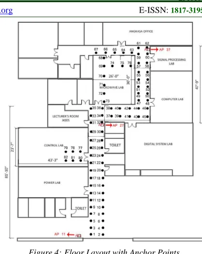
During this phase, the target location and the WiFi APs that involved in this research work are chosen. The chosen location is at Level 2, academic building of Faculty of Engineering and Built Environment, where the selected area nearby to the Institute of Space Science (ANGKASA), control lab, power lab and digital signal processing lab.
There are three APs that available in the chosen location, which are labeled as AP#37, AP#27 and AP#11. These APs provide an open
network service labeled as ‘UKM-Tetamu’. This
[image:3.612.310.519.71.333.2]location is chosen because it has a complete criterion to test the capability of wireless localization network in an indoor environment.
Figure 4:Floor Layout with Anchor Points
Among the criteria are:
i.) Has typical floor layout for indoor building
(approximately 90 - 95% of indoor coverage area) as illustrated in Figure 4.
ii.) This area has more indoor closure, compared to
the other places around the building and its interior designs increased the possibility of signal reflections
iii.) Every rooms and areas at the chosen location
being occupied by researchers and lecturers. As there are a lot of researchers and lecturers move around the area, the human absorption effects can be considered for future study.
iv.) Electronic devices and the electronic
measurement tools surrounding this area might also affect the RSS reading.
3.2 Access Points (APs)
There are total of 82 anchor points selected in the considered working area, and each of them is separated by 1.5m. All these anchor points cover almost the whole area including the laboratory rooms such as the control lab and the microwave lab. Distance between anchor points is fixed at 1.5m based on following reasons:
that can affect the accuracy of the RSS readings.
ii.) Exposure to reflection and fading: This area has a multiple wall partitioning especially near and inside the surrounding labs, thus will consider the reflection and multipath fading mechanisms.
iii.) Accuracy: Anchor points that are closed to
each other will give more accurate object localization. This is because in a closed, walled and limited moving area; the location of an object must be determined accurately.
3.3 Mobile Devices and Measurement Software InSSIDer Wi-Fi Network Discovery Tool [12] is chosen to measure the RSS at the chosen location. This software is installed inside the laptop version Fujitsu L Series. In addition to RSS, InSSIDer can measure the Medium Access Control (MAC) address and maximum data rate of each AP.
3.4 Clustering Phase – Localization of Users Mattteuci [11] explained how the clustering technique could be applied by using certain
algorithms such as K-means, hierarchy and
Gaussian probability. In this process, the clustering
preparation is done by using the K-means
algorithm. This means that the exclusive anchor points will be chosen to generate a new cluster group. In choosing the anchor points exclusively, there are some criteria that must be taking into account, which are:
i.) Signals from APs
ii.) Distances between anchor points
iii.) RSS readings at each anchor points
3.5 Clustering Phase – Signals from APs Each of the anchor points that served by the same APs would be considered as one cluster. This is because their RSS is based on their APs and it helps to limit the coordinate scope to be checked due to small number of anchor points serving the same APs. The inter-cell interference effect between three APs is not considered in this study to simplify the clustering process.
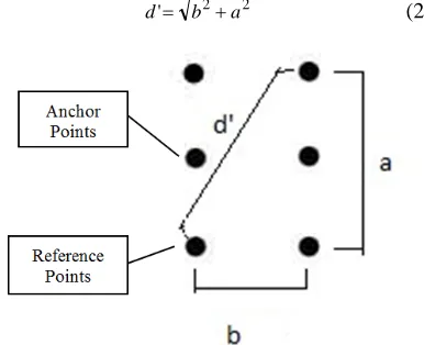
3.6 Clustering Phase – Distance between Anchor Points
The criteria to choose an anchor point based
on their APs is assumed to occur at the same time, based on the distance between the anchor points. From Equation(1), the Euclidean metric distance is measured to determine the distance between anchor points and APs in a cluster. However, the position
of the anchor points using this equation is random and does not have a fix distance.
Thus, estimation can be made so that it will give consistent results for different set of cluster that will be generated from the clustering criteria. Figure 5 shows the distance estimation process. As the distance between two anchor points is 1.5m, the accepted maximum distance between the anchor points and the reference anchor point to consider
the anchor point to b in the cluster is d’. The
reference anchor point in this case is the anchor point that is nearby to the serving AP.
Distance d’ is chosen to be the maximum
distance because its RSS readings at the anchor
point distance d’ is the minimum one. Thus, the
clustering process can be simplified because only the anchor points that received the highest RSS from the same APs are considered to form the same
cluster group. The equation to calculate d’ can be
expressed in Equation (2) where parameter b is the
horizontal distance between the anchor points
(measured 1.5m) and a is the vertical distance
between two anchor points (distance 3m).
[image:4.612.324.517.364.521.2]d'= b2+a2 (2)
Figure 5: Distance Estimation To Generate The Cluster Member From The Reference Points
3.7 Clustering Phase – RSS Readings at Anchor Points
After choosing the anchor points and the distance between anchor points, the RSS level will be used as the second criteria to form a cluster group. Only the anchor points with the same (or higher) RSS level is chosen to be in the same cluster group, while the others will be considered to form the next cluster group.
allow the anchor points that located closed to each other is chosen to be in one cluster. This also can help to determine the location of the object or users more accurately.
After the entire anchor points have been assigned to the specific clusters (based on the clustering criteria), the comparison process then takes place. During this process, the users’ location is compared with the anchor points’ location at each cluster.
4. RESULTS & DISCUSSIONS
4.1 Measurement Results
The RSS measurement was taken in the morning, at 11 am by using InSSIDer software [12]. It can be observed that the working area is quite busy with people moving in and out from the surrounding labs. From the RSS measurements, some analysis is done in order to establish a criterion to generate a cluster group
4.2 Clustering Results
The proposed clustering criteria can be described as follow:
i.) Choose the anchor points that received signals
from the same APs.
ii.) Distance between APs which is not more than
3.35m from any direction
iii.) Anchor points receiving signals not more than
30% difference
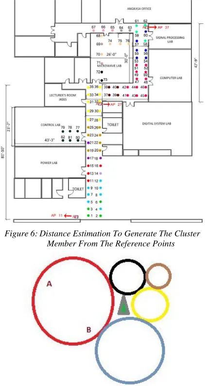
From the clustering criteria, 17 cluster groups have been generated, which is shown in Figure 6, where each colors at the anchor points in the floor layout represent each cluster group.
4.3 Localization Accuracy
From the generated cluster groups, user’s location can be predicted. A radio map can be developed, where it become the reference to determine the location of the users. Based on RSS readings and active APs, location of a user can be
known from the (x,y) coordinate. Measuring the
accuracy of the clustering technique can be done by comparing the readings from the offline and online phase. These comparisons are important to get accurate readings, either the readings that have been recorded during offline phase or the one in real time, which is directly received by the user.
To measure the accuracy of the clustering method, the cluster size must be taken into account. Accuracy improvement can be explained from Figure 7. Point A in the red cluster located at the most upper left while point B from the same cluster located at most lower right. Based on the cluster
[image:5.612.314.525.154.550.2]algorithm that has been presented earlier, both of these two points will become the same cluster member, hence their location appear the same to the mobile user.
Figure 6: Distance Estimation To Generate The Cluster Member From The Reference Points
Figure 7: Example Of Clusters That Have Been Developed
5. CONCLUSIONS & FUTURE WORKS
Localization of an indoor object can be done by using the clustering technique from the RSS measurement taken at the considered location area. It can be observed that the cluster size influencing the accuracy of the user location.
i.) Clusters within clusters technique: The location of the users is narrowed down to the inner cluster and hence, more accurate point can be localized.
ii.) Reducing the percentage of RSS differences: By reducing the percentage of RSS difference between the anchors points, fewer points can be considered in one cluster groups. Fewer points in a cluster group will generate more cluster members. Thus, it is expected to increase the accuracy of user’s location estimation.
iii.) Scalability of the cluster size: When working in
large indoor area, more cluster groups are needed. This is to improve the location estimation accuracy. The more the cluster groups generated, more accurate the user location estimation, thus user location can be predicted more accurately compared to fewer cluster groups available in the area.
In the online phase, application of fingerprinting technique will be installed in the mobile device to measure the location and the position of the user in real time.
6. ACKNOWLEDGEMENT
This work was supported by the Malaysia’s Ministry of Science, Technology and Innovation (MOSTI), under the grant ref: 01-01-02-SF0788
REFERENCES:
[1] H. Liu, H. Darabi, P. Banerjee, J. Liu “Survey
of Wireless Indoor Positioning Techniques
and Systems”, Journal IEEE Transactions on
Systems, Man, and Cybernetics, Part C: Applications and Reviews archive, Vol. 37(6), Nov 2007
[2] Hyo-Sung, A. & Wonpil, Y. “Indoor
Localization Techniques based on Wireless
Sensor Networks.” Electronics and
Telecommunications Research Institute (ETRI) Report, pp. 277-302. Korea.
[3] Ning, C., Rashid, R. & Majid, A. “Robust
Indoor Positioning using Differential Wi-Fi
Access Points.” IEEE Transactions on
Consumer Electronic”. 56(3):1860-1867. 2010
[4] Andrew, L. M., Kostas, B. E., Algis, R. P.,
Dan, W. S. & K. E. Lydia. “On the Feasibility of Using Wireless Ethernet for Indoor
Localization” IEEE Transactions on Robotics
and Automation, pp.555-559. 2004.
[5] Chao, C. “Design of a Child Localization
System on RFID and Wireless Sensor
Networks” Journal of Sensors, pp.1-8. 2010
[6] Lingxuan, H. & David, E. “Localization for
Mobile Sensor Networks.” MobiCom. pp.
1-13. 2004.
[7] Mert, B., Henry, X., Weiming, S. & Hamada,
G. “A 3-D Indoor Location Tracking and Visualization System Based on Wireless
Sensor Networks.” Proc. IEEE. pp.1-7. 2008
[8] Oliver, W. & Robert, H. “RF-Based
Initialization for Inertial Pedestrian Tracking” University of Cambridge Computer Laboratory Report. pp. 1-18
[9] Pavani, T., Costa, G., Mazzoti, M., Conti, A.
& Dardari, D. “Experimental Results on Indoor Localization Techniques through
Wireless Sensors Network.” 2010 IEEE
International Conference on Systems Man and Cybernetics (SMC), pp. 663-666. 2006
[10] Yiming, J., Saad, B., Santosh, P. & Prathima,
A. “ARIADNE: A Dynamic Indoor Signal Map Construction and Localization System.”
MobiSys, pp. 151-164. Uppsala, Sweden. 2006
[11] Matteuci, M. Politecnico di Milano. A
Tutorial on Clustering Algorithm [Online] http://home.deib.polimi.it/matteucc/Clustering /tutorial_html/index.html
[12] inSSIDer,http://www.metageek.net/products/i
nssider
![Figure 2: Distance between Clusters [10]](https://thumb-us.123doks.com/thumbv2/123dok_us/8914295.960939/2.612.323.510.261.400/figure-distance-between-clusters.webp)