White Rose Research Online URL for this paper: http://eprints.whiterose.ac.uk/107031/
Version: Accepted Version Article:
Prescott, T.J. (1996) Spatial representation for navigation in animats. Adaptive Behavior, 4 (2). pp. 85-123. ISSN 1059-7123
https://doi.org/10.1177/105971239600400201
[email protected] https://eprints.whiterose.ac.uk/
Reuse
Unless indicated otherwise, fulltext items are protected by copyright with all rights reserved. The copyright exception in section 29 of the Copyright, Designs and Patents Act 1988 allows the making of a single copy solely for the purpose of non-commercial research or private study within the limits of fair dealing. The publisher or other rights-holder may allow further reproduction and re-use of this version - refer to the White Rose Research Online record for this item. Where records identify the publisher as the copyright holder, users can verify any specific terms of use on the publisher’s website.
Takedown
If you consider content in White Rose Research Online to be in breach of UK law, please notify us by
Spatial Representation for Navigation in Animats
1Tony J. Prescott
Department of Psychology,
Sheffield University,
Sheffield S10 2TP,
United Kingdom.
Telephone +44 114 2826547
Fax +44 114 2766515
Email: [email protected]
To appear in Adaptive Behaviour 4(2), 1996.
Abstract
This article considers the problem of spatial representation for animat navigation
systems. It is proposed that the global navigation task, or wayfinding, is best supported
by multiple interacting sub-systems, each of which builds its own partial representation of
relevant world knowledge. Evidence from the study of animal navigation is reviewed to
demonstrate that similar principles underlie the wayfinding behaviour of animals
including man. A simulated wayfinding system is described that embodies and illustrates
several of the themes identified with animat navigation. This system constructs a network
of partial models of the quantitative spatial relations between groups of salient landmarks.
Navigation tasks are solved by propagating egocentric view information through this
network using a simple but effective heuristic to arbitrate between multiple solutions.
Keywords:
Animat AI; spatial representation; navigation; multiple sub-systems; quantitative models.
1
Introduction
The approach of ÔBehaviour-basedÕ or ÔanimatÕ artificial intelligence (AAI) (Brooks,
1995; Maes, 1992; Meyer & Guillot, 1990; Wilson, 1990) emphasises the role of the
agentÕs continuous interaction with its environment in driving the selection and
performance of behaviour. Further important themes include decentralized control;
targeting perception to the acquisition of task-relevant information (rather than the
delivery of a general description of the world); and incremental layering of competences
to provide robustness to error or failure. A typical AAI system is constructed from a
heterarchy of sub-systems each linking perception to action and fulfilling a specific
behavioural role.
AAI has something of an Ôanti-representationÕ bias. This is based in part on its success
in excising representational elements from control systems. The classic example (see e.g.
Maes, 1992) is the Ôwall-followingÕ robot that tracks the contour of a wall, negotiating
bends and corners, by exploiting some simple, pre-wired reflexes and biases. This robot
has little or no internal state, and certainly has no internal representation of the wall or of
its own relationship to it. AAI has had considerable success in applying similar
techniques to a range of local navigation skills, enabling mobile robots to move around in
the immediate environment quickly and safely (Brooks, 1989; Connell, 1990; Soldo,
1990). For any mobile agent, however, an immensely valuable skill is that of finding and
following paths to target locations in large-scale space (i.e. where targets may lie outside
the visible scene). This skill will be referred to as global navigation or, to use a term
common in the psychological literature, wayfinding. Unlike local navigation, which can
be achieved with minimal internal state, wayfinding requires internal structures that
encode at least some aspects of the agentÕs past experience of its environment. The
second section of this article therefore seeks to identify some characteristics that might
AAI looks to biology to provide examples of robust solutions to difficult problems,
and also seeks to inform biology by providing models of the mechanisms underlying
animal behaviour. The literature on animal and human wayfinding has been an important
source of inspiration for several navigational systems used in real and simulated
autonomous robots (Kortenkamp, Weymouth, Chown & Kaplan, 1992; Kuipers & Byun,
1987; Mataric, 1990; Touretzky, 1994). Section 3 of the article therefore gives a brief
review of evidence from the study of animal and human navigation, while section 4
attempts to find some convergent principles for navigation in both animals and animats.
A central objective of the article, and the topic of section 5, is to describe a simulated
wayfinding system that embodies and illustrates several of the themes identified with
animat navigation. This system, which has been partially described in (Prescott, 1993a;
Prescott, 1993b), supports global navigation behaviour through the construction and use
of multiple partial models of the quantitative spatial relations between groups of salient
landmarks. The description given here introduces and proves a novel heuristic that
substantially improves the effectiveness of the system in the presence of noise.
2
Representation for wayfinding in AAI
The notion of representation is sufficiently controversial to justify a brief definition.
Following Beer (1995) and Clark (to appear) identifiable elements of the agentÕs internal
state will be described as ÔrepresentationsÕ where assigning a content-bearing role is
helpful in understanding the overall causal process (the agent-environment interaction).
This definition puts the distinction between representation and not-representation firmly
in the mind of the observer, where its value is in determining concise and predictive
explanationsi. It also leaves open the debate about the nature of representations, and in
particular, does not equate representation with the notion of a central world model.
In fact, there is a clear lead for an AAI view of representation presented in the
literature (Brooks, 1995; Maes, 1992; Mataric, 1995; Roitblat, 1994) that converges with
follows. Each of the multiple sub-systems, that comprise the overall control architecture,
maintains representations of those aspects of the world that it finds relevant. Accordingly,
instead of a central and unified model of the world, knowledge is distributed between
many partial representations focused on specific tasks. Where appropriate such
representations may encode the agentÕs interaction with the world rather than modelling
the structure of the world directly. There is no strong distinction between memory and
processÑknowledge may be intricately bound up with processing mechanisms. Finally,
representations may be implicit and distributed in the Connectionist sense (e.g. Hinton,
McClelland, & Rumelhart, 1986), in that an entity may be represented by a pattern of
activity across many processing elements that emerges in the context of appropriate
perceptual and internal states.
The following sub-sections consider the implications of this view for AAI approaches
to the wayfinding problem.
2.1 Multiple, partial representations of the world
The focus of much of the research in global navigation for mobile robots has been the
task of planning optimal paths using an appropriately detailed and accurate metric map of
the spatial layout of the environment (Chatila, 1986; Crowley, 1985; Iyengar, Jorgensen,
Rao & Weisbin, 1985; Lozano-Perez, 1983; Rao, Stoltzfus & Iyengar, 1988; Turchan &
Wong, 1985). The AAI approach suggests an alternative view in which the navigation
problem is fragmented into a number of distinct, interacting sub-systems, where each
subsystem builds its own partial representation of the world. Alternative sub-systems
differ in the environmental characteristics, sensor modalities, and computational
mechanisms they exploit, and the sorts of representations they construct. There are
significant advantages to this fragmentation. First, the ability to exploit different
wayfinding methods provides robustness by reducing the dependence on specific cues
and sensor channels. Second, by exploiting multiple representations, alternative
hypotheses about the structure of the environment can be encoded. Mutually consistent
navigation goes wrong (i.e. when the Ôfirst choiceÕ hypothesis fails there are other
plausible candidates to be investigated). It will be appropriate to maintain separate models
for these different sub-systems in as much as they exploit different spatial constraints,
maintain useful alternative hypotheses, or suit representational forms that may not be
easily or cheaply integrated into a unified model. A navigation system of this sort may
exploit distributed representations of the environment (in the sense defined above)Ñthat
is, rather than coding explicit representations of estimates of spatial relationships,
appropriate estimates may be generated dynamically through the interaction of multiple
models, with each other and with available perceptual data, in the context of a specific
navigation task.
2.3 Agent-centered representations
One of the simplest forms of representation for wayfinding is a sequential record of the
agentÕs own actions in specific perceptual contexts. Memory for such sequences provides
the basis for what is termed route knowledge (OÕKeefe, 1990b; OÕKeefe & Nadel, 1978).
The ability to memorise and follow routes seems to account for many aspects of animal
and human navigation behaviour (OÕKeefe & Nadel, 1978). This principle has also been
used to guide autonomous robots (Connell, 1988). The underlying representational form
of route knowledge can be characterised as a chain of stimulus x action -> next stimulus
associations. One of the attractions of such chains is that each link is built from the
elementary sensorimotor experiences of the agent. There is no need to maintain an
allocentric (world-centred) frame of reference, or to translate the (egocentric) experience
of the agent into such a frame. The world itself is represented only in an indirect fashion.
OÕKeefe (1990c) identifies two categories for the elements of route knowledgeÑ
associations that involve approaching or avoiding specific cues are termed guidances,
whilst those that involve performing a body-centred action (generally a rotation) in
response to a cue are termed orientations. Such associations have a ÔdeicticÕ quality as
defined by Agre (1991) in that objects are indexed according to the properties that make
Òmove towards the red beaconÓ, or the orientation Òturn left at the lightsÓ, is each
meaningful and unambiguous only in the context of appropriate circumstances and goals.
Although route knowledge can support effective wayfinding behaviour it is important
to recognise that it has significant limitations. Since route models do not explicitly encode
the underlying invariant spatial relations between locations in the environment, they are
unsuited to the problem of determining novel paths between places. This lack of
knowledge about how different places in the environment are related also means that it is
difficult to find and re-establish position on a route if the agent becomes lost.
2.4 World-centered representations
To support more flexible wayfinding behaviour than is possible on the basis of route
knowledge, requires representations that encode the spatial layout of the environment.
Further choices exist, however, as to the nature of the spatial relations that are learned.
An important distinction, that has been a focus of interest in AAI research on wayfinding,
is that between qualitative and quantitative spatial models. Several researchers associated
with AAI (Kortenkamp et al., 1992; Kuipers & Byun, 1991; Shšlkopf & Mallot, 1995)
have advocated the use of qualitative, non-metric models of space, based principally on
representations of topological spatial relations (connectedness, containment, and order),
in preference to the quantitative, metric modelling approach that has been the norm in the
robot navigation literature. A topological model of the layout of the environment can be
assembled from sequential models of the type that underlie route knowledge. The
development from route models to topological models is therefore of an incremental
character fitting the ÔevolutionaryÕ bias of AAI that sees the development of complex or
powerful systems as a process that exploits the building blocks provided by simpler and
weaker systems (Brooks, 1995; Kuipers & Byun, 1991). Forming a layout representation
requires the ability to recognise where route models overlap, implying the use of place
identification skills that allow the agent to judge when experiences separated by arbitrary
Though it has been suggested that topological modelling is less demanding in terms of
sensor accuracy and computational resources than metric modelling (Kuipers & Byun,
1991; Kortenkamp, et al., 1992) such arguments are difficult to prove. Clearly topological
modelling has a lesser need for accurate metric sense data, however, the problem of place
identification is such that robustness to inaccurate or absent metric data must be achieved
by improving the pick-up of non-spatial sensory characteristicsÑpoor metric sensing
must be compensated for by better pattern matching (an extended argument for view is
given in Prescott, 1993b). Arguments about the relative computational expense of metric
and non-metric systems will also be hard to make without direct comparisons between
systems of similar competence. Costs will depend as much on the type of representation
stored and the nature of the mechanisms used to handle inaccuracy and uncertainty, as on
any inherent differences due to geometric character. Finally, the overheads associated
with a given method will depend on its appropriateness to the navigational task, for
instance, topological models may suit constrained environments of corridors and tunnels
that are easy to segment into the vertices and edges of a graph representation but be less
suited to open terrain (again see Prescott, 1993b).
Topological modelling is at one end of a range of alternatives to the use of metric
models of spatial layout. One of the senses of qualitative navigation is the use of
categorical or relative judgements of geometric relations implied by terms such as ÔnearÕ,
ÔfarÕ, ÔcloserÕ, ÔfurtherÕ, ÔmiddleÕ. Some of these judgements can be based on
uncalibrated sensor readings, for instance, a robot can follow the middle of a corridor by
keeping left and right sensor readings in balance (e.g. Kuipers & Byun, 1991). Other
qualitative judgements will require rough calibration or the use of fuzzy sets to classify
sensor readings. Projective and affine geometries introduce additional, more quantitative,
constraints and may be appropriate in some circumstances. For instance, the system
described in Section 5 encodes affine spatial relations (although metric relations are
recoverable given calibrated metric sensors), which allows co-ordinate transforms to be
easily computed. Non-Euclidean geometries such as the Ôcity-blockÕ metric may also be
Qualitative models of spatial layout have an important advantage over route
knowledge, in that they allow the agent to generate novel routes (using known path
segments). However, such models do not allow the determination of Ôstraight-lineÕ routes
or of short-cuts that cross unexplored terrainÑsuch skills require knowledge of the
quantitative spatial relations, direction and distance, between locations. In view of the
importance of effective wayfinding to autonomous agents this is a very significant point
in favour of the use of quantitative spatial knowledge.
As noted above, many quantitative navigation systems seek to construct maximally
accurate metric world models. Such an aim can justify the construction of a unified
model, into which all available observations are integrated, as the most efficient way to
minimise errors in estimates of spatial position (Smith, Self & Cheeseman, 1990).
However, from the point of view of a navigator, accuracy may not be the key criterion for
determining the adequacy of its spatial knowledge. This is shown by recognizing that
effective wayfinding rarely needs an accurate assessment of the position of a remote
targetÑa navigator who begins with just a coarse estimate of the required heading can
Ôhome-inÕ on the distant goal by making successive corrections based on incoming
perceptual data (Jamon, 1990). Rather than seeking to maximise accuracy, the AAI
approach emphasises strategies for coping with the inevitable error and uncertainty
attached to acquired knowledge. This can involve the use of opportunistic planning
techniquesÑof which the homing-in strategy is an exampleÑto exploit sensor data
whenever possible and minimise the use of stored knowledge, and the use of the
redundancyÑprovided by multiple competencesÑto provide robustness to sensor error
or failure. The position of this article is that quantitative navigation methods, developed
along these lines, can support robust and effective wayfinding in autonomous agents.
3
Representation in natural navigation systems
There are several good reasons why AAI looks for clues in the understanding of
domain of folk psychology and introspection that has been a fertile ground for several
questionable ideas, not least those concerned with the notion of central world model. A
further reason is that natural systems embody robust solutions to difficult problems.
Although on a species level these may be somewhat specialised, the existence of
characteristic properties that extend across species suggest principles of general
importance to the design of autonomous agents. The literature on navigation in natural
systems, suggests that there is, indeed, a great diversity of solutions to the wayfinding
problem, and that many natural systems are highly specialised to specific environmental
niches. It is argued below, however, that there is a commonality across many species
which relates to the use of multiple sub-systems for the control of navigation behaviour,
and the exploitation of quantitative knowledge of environmental spatial relations.
2.1 Animal navigation
The literature on animal spatial learning differentiates the wayfinding skills of most
invertebrates and lower vertebrates, from those of higher vertebrates (birds and
mammals). In particular, it suggests that wayfinding in many invertebrates uses path
integration mechanisms (integrating changes in position from sensory signals), compass
senses (determining orientation by using non-local cues such as the sun, or by sensing
physical gradients such as geomagnetism), and piloting (orienting to specific remembered
stimulus patterns)
(Cartwright & Collett, 1979; Cartwright & Collett, 1983; Cartwright & Collett, 1987;
Wehner, 1983; Wehner & Menzel, 1990). Invertebrates do not appear to memorise the
spatial layout of their environment, and as a consequence, their wayfinding behaviour
may be restricted to homing and retracing familiar routesii. In contrast, there is evidence
that higher vertebrates do learn the spatial layout of their environments (see, for example,
Gallistel, 1990; OÕKeefe, 1990c; OÕKeefe & Nadel, 1978; Olton, 1982) enabling them to
generate and follow more efficient paths to distant targets. The literature on vertebrate
navigation further suggests a discontinuity between route knowledge and the use of
For instance, OÕKeefe (OÕKeefe, 1990b; OÕKeefe & Nadel, 1978) has argued that there
are two largely separate navigation systems used by mammals including man. The first of
these, which he calls the taxon system, is supported by chains of guidance and orientation
associations and underlies some of the route-following abilities seen in animals.
OÕKeefeÕs second system, called the locale system, constructs a layout model describing
the metric spatial relations between locations in the environment. Evidence for the
existence of this system and its independence from taxon strategies consists of both
observational and laboratory studies of animal behaviour (e.g. Chapuis, Thinus-Blanc, &
Poucet, 1983; Poucet, Thinus-Blanc, & Chapuis, 1983), and neurophysiological studies
suggesting that different brain structures underlie the two systems (Morris, Garrud,
Rawlins & OÕKeefe, 1982). Gallistel (1990), who provides an extensive review of
research on animal navigation, also concludes that many animals navigate on the basis of
metric models of space.
OÕKeefeÕs distinction between taxon and locale systems follows a long line of research
into ÔresponseÕ versus ÔplaceÕ knowledge in animal navigation (see Olton, 1979; Olton,
1982; Gallistel, 1990) that shows the existence of complimentary navigation systems in
animals. This literature also demonstrates, that there may be no simple hierarchical
arrangement of control. For instance, in experiments on the maze learning behaviour of
rats, response knowledge (chained motor responses) appeared to predominate in some
experimental situations and place knowledge (encoded spatial relations) in others. The
importance in animal navigation of multiple, redundant, mechanisms for achieving
navigational goals, and the existence of mechanisms for arbitrating between available
alternatives is demonstrated by a number of studies. The following briefly reviews some
of this research.
Poucet and co-workers (Poucet, et al., 1983; Chapuis, et al., 1983) provide evidence
from cats and dogs for the distinction between taxon and locale systems and demonstrate
some of the characteristics of the arbitration process that chooses between them. In their
experiments, animals were forced to choose between two paths from a starting point to a
the goal was determined by an arrangement of screens that were either transparent or
opaque. When the screens were transparent, the animals preferred the path with the
smallest angular deviation even where this involved travelling a greater distance. When
the screens were opaque animals preferred the shortest route regardless of the angular
deviation. These results suggest that, when the goal is visible, a guidance system (taxon)
is triggered that causes the animal to try to move along the direct line toward the goal,
whereas, when the goal is not visible, the locale system is operated which selects the
shortest available path. Interestingly the taxon system predominates over the locale
system in the case of a visible goal, even though, in this case, it results in sub-optimal
navigation behaviour.
Etienne (1992) reports experiments that show the existence, in the golden hamster, of
independent wayfinding mechanisms derived from different sensory modalities,
specifically, by dead-reckoning (proprioception) and with respect to (visual) landmarks.
Hamsters have effective dead reckoning skills that are sufficient to relocate their nest in
darkness. However, in lighted conditions, hamsters were found to orient primarily using
visual information about local landmarks. In conflict situations, where a landmark (a
single light spot) was rotated relative to the learned position, the hamsters homed using
either the landmark information or their dead-reckoning sense. When the visual
information and dead reckoning produced highly divergent paths dead reckoning was
used, however, with smaller discrepancies visual information took priority over path
integration. This last finding suggests a relatively sophisticated arbitration process for
handling inconsistencies between different sources of direction information.
Experiments by Collett, Cartwright, and Smith (1986) with gerbils demonstrate the use
of multiple redundant spatial representations derived from a common source. These
animals appear to encode goal positions (buried sunflower seeds) in terms of individual
visible landmarks by using some form of direction sense. In one experiment, gerbils were
trained to locate a food cache at the centre of an array of two landmarks. When the
distance between landmarks was doubled the gerbils searched at two sites each at the
locations (as some theories of a landmark ÔmapÕ might predict). In a further experiment
the gerbils were trained to go to a goal-site at the centre of a triangle of three landmarks.
During testing the distance of one landmark to the centre was doubled. Collett et al. report
that the animals spent most of their search time around the place specified by the two
landmarks, ignoring the one that broke the pattern. They interpreted this result in the
following way:
ÒThe gerbil is thus equipped with a useful procedure for deciding between discrepant
solutions. When most of the landmarks agree in specifying the same goal, with just a
few pointing to other sites, the chances are that the majority view is correct and that
the additional possibilities result from mistakes in computation or from disturbances
to the environment.Ó (Collett, et al., 1986).
Collett et al. are therefore suggesting that the multiple encoding of landmark-goal
relations by gerbils occurs to provide the system with robustness. The gerbils appear to
maintain distinct representations of the relative position of the goal to each landmark,
rather than constructing a unitary representation of the landmark array and the goal. The
Ôbest guessÕ as to where the target is located is decided by some form of ÔvotingÕ
arbitration scheme at the moment when such a decision is needed.
Among researchers who regard the locale system in animal navigation as a metric
cognitive map (Gallistel, 1990; McNaughton, Chen & Markus, 1991; OÕKeefe, 1990b;
OÕKeefe & Nadel, 1978) there is some disagreement over the relative importance of dead
reckoning and environmental fixes in constructing the map. This may suggest that the
locale system is less of a unitary system than has been supposed. McNaughton, Chen, and
Markus (1991), and Gallistel (1990) have argued that the principal sources of position
information for map-building are dead-reckoning skills and compass senses. These skills
are used to maintain an estimate of current position and heading relative to the origin (e.g.
the nest) of a global allocentric frame. Places are coded in terms of the distance and
direction from this origin or from single landmarks whose positions in the global frame
coding system. An alternative view, proposed, for instance, by OÕKeefe (1990c), is that a
place is encoded in terms of the array of local landmarks visible from that position. In
other words, that the cognitive spatial representation stores the locations of potential goals
in allocentric coordinate frames determined by groups of salient cues. Such a system is
here called a relational coding. Both vector and relational coding theories are backed up
by substantial empirical evidence, hence, it seems unlikely that this debate will be easily
resolved in favour of one side or the other. It seems plausible instead, that, in appropriate
circumstances, animals may exploit both vector and relational coding mechanisms to
generate complimentary models of space.
2.2 Human navigation
One of the motivations often cited (Kuipers & Byun, 1991; Yeap, 1988) for
investigating qualitative navigation systems is research on human wayfinding. Much of
this literature follows a theory originating with Piaget (Piaget, Inhelder & Szeminska,
1960) that human spatial knowledge has a hierarchical structure and is acquired through a
stage-like process. Specifically, Piaget, and later Siegel and White (1975), argued that a
fundamental stage in the acquisition of spatial knowledge is the construction of
qualitative models of the environment from more elementary sensorimotor associations.
This representation may be supplemented later by distance and direction information to
form a more detailed quantitative map. Computational models, inspired by the (Piagetian)
human wayfinding literature, have been described by Leiser (Leiser & Zilbershatz, 1989)
and by Kuipers (Kuipers, 1982; Kuipers & Byun, 1991; Kuipers & Byun, 1987; Kuipers
& Levitt, 1988). Kuipers, in particular, has developed a number of robot simulations
based on the hypothesis of a Ôsemantic hierarchyÕ of spatial knowledge, which has been
influential in other recent work on robot wayfinding (e.g. Levitt & Lawton, 1990). The
Ôsemantic hierarchyÕ hypothesis sees the acquisition of spatial knowledge as assembling
spatial knowledge on four levels termed sensorimotor, procedural, topological, and
metric, it thus proposes, as in this article, that navigation behaviour should be supported
One of the difficulties with some of the early studies on human navigation was the
assumption that a metric Ôcognitive mapÕ would be something like an image of a
cartographic map. Experiments that found errors in spatial knowledgeÑdistortion, gaps,
holes, fault-lines, and asymmetriesÑwere therefore taken as evidence against the use
metric representations and in favour of more qualitative systems. However, although
there is little support for this notion of a metric Òpicture in the headÓ (see, for instance,
Kuipers, 1982), there is good evidence that metric spatial representations, of a quite
different kind, form an important element of human wayfinding competence (see Presson
and Hazelrigg, 1984; Scholl, 1992; and McNamara, 1992, for reviews). Some of the
distinctive properties of these representations are demonstrated in an experiment by
Scholl (1987), which contrasted the spatial knowledge acquired through direct experience
of the environment with that acquired indirectly by memorising a cartographic map. In
the case of knowledge acquired from a map, a task of Ôpointing to unseen targetsÕ showed
that the stored representation had a preferred orientationÑpointing was easier when the
subject was aligned with the North-South axis of the map. Further, with this type of
knowledge all coded locations could be accessed with equal ease (as though one was
Ôlooking downÕ on an aerial map of the environment). In contrast knowledge acquired
from direct experience showed no preferred (absolute) orientation although, importantly,
targets in front of the body were located more easily than ones behind. Scholl (1992)
argues, on the basis of a number of studies of this nature, that human cognitive spatial
representations encode allocentric spatial relations abstracted from the stream of local
egocentric views experienced during movement. Furthermore, this store of knowledge
has no inherent orientation. Whenever it is accessed, the representation of the world
appears to be automatically aligned with the body, anticipating objects that are about to
become visible. From this view, the internal representation is not a static and explicit
model within which the navigator tracks his or her own position and orientation. Instead,
spatial knowledge seems to be encoded in an implicit and distributed store, from which
perceptual experience evokes a set of expectations that are always centred and oriented to
4
A Multiple schemata view of animat navigation
Arbib (1989, 1990) has proposed the term schemata to describe active representational
systems or Òperceptual structures and programs for distributed motor controlÓ (Arbib,
1989). A similar definition is given by Neisser (1976) for whom a schema is an Òactive
information seeking structureÓ defined by Òinformation pickup and actionÓ. NeisserÕs
conception of human cognitive maps as Ôorienting schemataÕ has been adopted by Scholl
(1987, 1992) as a framework for understanding the dynamic nature of the spatial
representations underlying human wayfinding. Here, and in (Prescott, 1993b; Prescott,
1994), I argue for a Ômultiple schemataÕ view of the use of spatial representations for
navigation in animats.
The emphasis of a multiple schemata approach, as defined here, is not on constructing
unified representations such as global topological or metric maps but rather on
establishing multiple, partial models. Each schema will encode spatial constraints derived
from the interaction with the environment, which in the context of appropriate sense data,
can determine navigation behaviour. For instance, as in EtienneÕs experiments with the
golden hamster, a Ôdead reckoningÕ schema can maintain an estimate of the homing
vector based on proprioception, whilst a second ÔlandmarkÕ schema represents the relative
position of the home with respect to a salient landmark. Both schemata can then
independently direct homing behaviour, or can combine for a more robust result.
Different schemata are defined, not so much by the sort of geometric relations they
preserve, but by the channels and mechanisms through which the encoded relations are
derived and applied. For instance, separate metric schemata can derive from different
sensory modalities as is the case with the Ôdead reckoningÕ and ÔlandmarkÕ schemata.
They can also derive, however, from within a single sensory modality by reference to
different environmental cues. For example, the observed position of a single distant
landmark (e.g. the sun) can be employed to encode a direction constraint distinct from
spatial localisations obtained with respect to local landmarks. Indeed, different individual
Collett et al.Õs experiments with gerbils, and in the system described below. Distinct
schemata may also be derived from within a given modality and by reference to the same
external cues but by employing different computational mechanisms. For instance, the
visual characteristics of landmarks might be used to model topological relations while
other mechanisms extract distance and direction from the visual scene. Only in this latter
sense will geometric content provide an important criterion for distinguishing between
schemata.
For a given navigational task, arbitration schemes will be needed to determine the
relative contributions of available schemata to navigation behaviour. This arbitration
could be carried out through some fixed subsumption mechanism whereby, for instance,
knowledge derived from a metric representation of spatial layout could override
route-following strategies. Alternatively a more sophisticated system would seek to
discriminate between multiple schemata by judging each according to its expected
accuracy or reliability. In this way, reliable identification of a distinctive landmark might
override estimates of spatial position or orientation determined by some metric reckoning
process. Although some tasks may require the temporary creation of a unified model
(drawing a graphical map of the environment might constitute such a task), in general the
underlying representations will remain distinct so that (possibly conflicting) alternatives
are not lost.
A multiple schemata view can help in understanding the evolution of multiple
wayfinding competences in animals (as reviewed above). It also provides support for the
essentially pragmatic approach in AAI to robot navigation. AAI has rightly begun by
developing competences similar to OÕKeefeÕs taxon systems that exploit the good
odometry information available to robots and use orienting and guidance strategies to
implement route-following behaviours (e.g. Connell, 1988). To achieve wayfinding skills
of the more powerful and flexible variety seen in vertebrates, taxon mechanisms must be
complimented by navigation systems that encode the spatial layout of the environment.
Such systems may, however, consist of multiple, partial models of the kind proposed
5
A distributed animat navigation system
This section describes in detail a distributed mapping system that constructs multiple
partial models of quantitative spatial relations. The system is built using local co-ordinate
frameworks defined by groups of salient landmarks. Specific locations are redundantly
coded by their relations to a number of local landmark frames. Large-scale spatial
relations are implicitly encoded in a network of nodes encoding local landmark/frame
relations. The computations required to construct these models from noisy, egocentric
metric data require only simple mathematics (indeed a connectionist learning rule can
suffice) and have memory requirements roughly proportional to the number of goal-sites
and landmarks stored. The task of determining direction or path information to a distant
goal is performed by a parallel, spreading activationiv
search in which estimates of
landmark positions are propagated through the network. As landmark positions are
redundantly encoded, the system generates multiple solutions for any task and uses an
arbitration procedure to select between alternatives. While moving towards a goal the
system exploits run-time error-correction by incorporating egocentric fixes on sighted
landmarks to increase its robustness to noise in the representation or perceptual system.
There is no permanent, explicit representation of the environment layout in this system,
instead, the changing local view of the agent triggers a changing pattern of activity in the
network that can be interpreted as a dynamic ÔmapÕ centred on and oriented to the agent.
It will be proposed that this method can provide robust support for wayfinding without
being expensive in terms of computational power or memory, and without requiring
complex coding mechanisms. These properties encourage the view that similar
mechanisms could support wayfinding for an autonomous mobile robot. Although the
system is not proposed as a model of any natural navigation system, it will also be
5.1 Relational models of space
A quantitative model of environmental layout is achieved by integrating observations
from different egocentric view-points into representations with respect to
environment-centred co-ordinate frames. There are two principle methods for representing spatial
relations in allocentric co-ordinate frameworks. The first is that all objects are referenced
with respect to a single global framework. As has already been noted, this method has
certain advantages if the goal is to maintain the most accurate overall model. The second
method is to form a network of local frameworks, where each frame is defined with
respect to an individual object or group of objects. The relation between any two distant
objects is then found by a sequence of transformations between adjoining reference
frames (Brooks, 1985; Levitt & Lawton, 1990). This second, relational coding method,
which exploits multiple partial representations, is preferred here for the reasons given in
the previous section. The system to be described makes no use of many important sources
of location information such as compass senses or dead reckoning. Clearly a robust
navigation system will seek to use spatial knowledge derived through such channels. The
aim here, however, is limited to the investigation of a distributed architecture that
generates multiple redundant codings using information from a single modality.
The task of navigating a large-scale environment using relational methods divides into
three problems: identification and re-identification of salient landmarks; encoding, and
later remembering, goal locations in terms of sets of visible local cues; and finally,
calculating paths between positions that share no common view. The first task, landmark
identification, has been considered (though not entirely solved!) elsewhere, both from the
point of view of animal and robot navigation systems (Levitt & Lawton, 1990; OÕKeefe,
1990b; Zipser, 1983a; Zipser, 1986). In this article, landmarks are taken to be objects (or
parts of objects) with locally distinctive secondary characteristics that can be identified
with (roughly) zero-dimension locations in egocentric space. The agent is assumed to be
able to detect suitable landmarks and determine, at least approximately, their positions
relative to itself. This simplification is made in order to allow the investigation of the
If position estimates can be accurately determined from the stored relational models
then the place identification problem, which is critical to the task of constructing any
layout model, is easily resolvedÑplaces (or landmarks) are identical that have the same
coordinates with respect to the allocentric frame. Generally, however, we wish to assume
error, possibly of a large or cumulative nature, in the estimates of spatial position. In this
case, the identification problem still exists though the estimates of spatial position now
provide powerful constraints to any matching process that exploits non-spatial sensory
characteristics.
5.1.1 Proposed relational coding methods
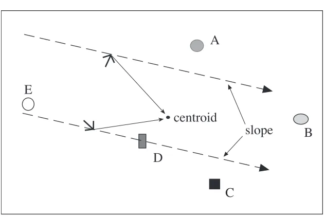
A proposal for a relational coding system, presented as a theory of the hippocampal
mapping system in the rat, has been provided by O'Keefe (1990a, 1990c) who suggests
that the rat brain computes the origin and orientation of a polar coordinate frame from the
vectors giving the egocentric locations of the set of salient visible cues. Specifically, he
proposes that these location vectors are averaged to compute the origin (or centroid) of
the polar frame, and that the gradients of vectors between each pair of cues are averaged
to compute its orientation (or slope). Goal positions can then be recorded in the
coordinate system of this allocentric frame in a form that will be invariant regardless of
the position and orientation of the animal. This idea is illustrated in Figure 1.
---
Figure 1 about here.
---
This proposal has, however, a number of problematic characteristics. First, the
computation of the slope is such that the resulting angle will differ if the cues are taken in
different orders. Since any ordering is essentially arbitrary, a specific sequence will have
to be remembered in order to generate the same allocentric frame from all positions
within sight of the landmark set. Second, as landmarks move out of sight, are occluded by
Rather than changing the global frame each time a landmark appears or disappears it
seems more judicious to maintain multiple local frames based on subsets of the available
cues. These would supply several mutually-consistent encodings making the mapping
system robust to changes in individual landmarks.
The use of multiple local frames has been proposed by Levitt and Lawton (1990).
They observe that the minimum number of landmarks required to generate a coordinate
frame is two (in two-dimensions, three in three-dimensions). They also provide a useful
analysis of how the constraints generated by multiple local frames can be combined, even
in the presence of very poor distance information, to provide robust location estimates. To
calculate, from a novel position, a goal location that has been encoded in a two-landmark
frame requires non-linear computations (trigonometric functions and square roots). It
also requires that an arbitrary ordering of the two landmarks is remembered in order to
specify a unique coordinate system. Among the concerns that has motivated the recent
interest in qualitative modelling has been the resource demands of this need for
continuous, computationally expensive co-ordinate transforms (Kortenkamp et al., 1992).
Zipser (1986), who had earlier considered a landmark pair method (Zipser, 1983b),
points out that if one more landmark is used to compute the local frame then all the
calculations are greatly simplified. In fact, all that is required to encode a goal location
using three landmarks (in two dimensions, four in three dimensions) is that one constant
is associated with each cue. Zipser called these constants beta-coefficients, they are,
however, identical to the barycentric coordinates that have been known to
mathematicians since Moebius (see for instance Farin, 1988). The system for large-scale
navigation described below uses this three landmark method and it is therefore described
in detail in the following section. In the remainder of the article the navigation problem
will be considered as two-dimensional, however, the extension of these methods to three
5.1.2 The Beta-coefficient coding system
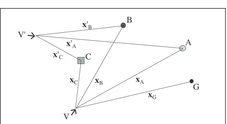
Figure 2 shows the relative locations of a group of three landmarks, hereafter termed
an L-trie, labelled A, B, and C, seen from two different viewing positions V and V ʹ. A
goal site G is assumed to be visible only from the first viewpoint.
---
Figure 2 about here.
---
The column vectors xi =(xi,yi,1)
Τ
and x ʹi =
(
x ʹi,y ʹi,1)
Τ
give the location in
homogeneous coordinates of object i in the egocentric frames centred at V and V ʹ
respectively. The two frames can therefore be described by the matrices
X=
[
xA xB xC]
, and X ʹ=[
x ʹA x ʹB x ʹC]
(1)If the three landmarks are distinct and not collinear then there exists a unique vector
β=(βA,βB,βC)Τ such that
Xβ =xG and X ʹβ =x ʹG. (2)
In others words, by remembering the invariant β the egocentric goal position from
any new viewing position V ʹ can be determined by the linear sums
ʹ
x G =βAx ʹA +βBx ʹB +βCx Cʹ, ʹ
y G=βAy ʹA +βBy ʹB +βCy ʹC, (1 =βA +βB +βC).
(3)
Note that since each constant is tied to a specific cue the ordering of the landmarks is
irrelevant.
The beta vector can be determined directly by computing the inverse matrix X−1 since
β=X−1Xβ
=X−1x
G
Though this inverse calculation uses only simple arithmetic, the value of the
beta-encoding as a possible biological model has been questioned on the grounds of its
apparent mathematical complexityv (Worden, 1992). However, as Zipser (1986) points
out, the same computation can be achieved by a gradient descent method, and so can be
viewed as adapting the connection strengths of a simple learning unit using a supervised
learning rule. A network architecture that instantiates such a mechanism is as follows.
The network consists of two types of processing unit. The first are object-position units
(object-units henceforth) whose (vector-valued) activations represent the locations in
egocentric space of specific goal-sites and salient landmarks. The activations of these
units can be set in two possible ways. First, for goals and landmarks that are visible,
sensor systems identify the relevant objects and determine their positions in the agentÕs
current egocentric reference frame. Second, for objects outside the current field of view,
activations can be determined by propagating egocentric position estimates through the
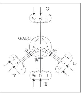
network as explained below. The second type of processor is termed a beta-unit. This unit
receives input from three object-units and adapts its connection strengths (the beta
coefficients) to match its output to the activation of a fourth.
An example of this architecture is illustrated in Figure 3, which shows a beta-unit
G/ABC that receives the positions of the landmarks A, B, and C, and the goal, G, as its
inputs. When all three landmarks and the goal are visible, the unit can adapt the weights
(βA,βB,βC) to reduce the discrepancy between its output (x,y,z) and the goal vector
(xG,yG, 1). When the three landmark nodes (A, B, and C) are active, and the goal G is
inactive, a egocentric position estimate for G can be computed, according to equation 3,
and propagated to the goal unit. To adapt the beta values by gradient descent, a suitable
rule for the update at each iteration of the weight βi from the ith object is
Δβi =α
[
(xG −x)xi +(yG −y)yi+(1−z)]
(5)---
Figure 3 about here.
---
To provide a more intuitive understanding of the beta-coding a geometrical
interpretation can be given. Consider landmark A in L-trie ABC in Figure 4. The
perpendicular hA from A onto the line BC, defines one of the three axes of the
barycentric coordinate frame generated by the spatial configuration of the three reference
cues. For a given goal position G, the coefficient βA with respect to landmark A, is the
projection of G onto this axis. In other words, βA is the ratio of the two perpendiculars
hG hA (or, equivalently, the ratio of the areas of the triangles GBC and ABC).
---
Figure 4 about here.
---
This coding system in fact records affine rather than metric spatial relations, hence,
another term for the coefficients is affine coordinates. However, assuming that the agent
detects metric egocentric spatial relations according to a calibrated Euclidean measure,
metric relations will be recoverable from the stored model.
5.2 Recognising poor cue configurationsÑa simple technique for improving the beta-coding
An important problem that arises in using the beta-coding method with noisy data is
that the spatial arrangement of the reference and target landmarks has a marked affect on
the size of the error in the beta-coefficients and in any subsequent estimate of the targetÕs
position. For instance, if all the landmarks in the L-trie group lie exactly along a line, the
matrix X will be singular and the beta-coefficients for any target will be undefined. In
general, landmark groups that are near collinear will also give large errors when
computing cue positions in the presence of noisevii. The position of the target landmark
close to, or inside, the L-trieviii. Estimating the covariance of the errors in the
beta-coefficients is difficult because of the non-linearities in their calculation, however, there
is a simple heuristic that is effective at identifying poor cue configurations. Specifically
the size of the beta-coefficient vector can be used to indicate the likely size of the error in
the computed target position. This is possible because, as is shown below, the component
of the error that changes with the configuration of landmarks is scaled by the value of the
estimated beta vectorÑcodings with larger vectors will, on average, have relatively large
errors in the presence of perceptual noise. This technique makes few assumptions about
the structure of the perceptual data and should therefore be applicable across a range of
noise distributions. The following sub-sections show the derivation of this heuristic, and
suggest how it can be applied in an estimator that improves the accuracy of a beta coding
by combining repeated measures.
5.2.1 The size of the beta vector as an estimate of target error
In order to examine the relative stability of different cue configurations, the
relationship between perceptual error, in observed cue positions, and the error in a
computed target position is analysed. To account for noise in the perceptual system both
of the expressions in equation (2) are expanded to show the (unknown) errors, hence,
xG +δxG=
(
X+δX)
(
β+δβ)
, and (6)ʹ
x G +δ ʹ x G =
(
X ʹ +δ ʹ X)
(
β+δβ)
(7)We wish to see how the perceptual errors δX,δxG, and δX ʹ affect the computed error
δx ʹG in the estimate of the target position. First, note that the matrix X Xʹ −1
represents the
co-ordinate transform between the reference frames X and X ʹ. The two noise-free
measures of the goal position are therefore related by
ʹ
x G =X Xʹ −1
xG. (8)
Multiplying both sides of (6) by this transform gives
ʹ
Now subtract (9) from (7) to give the error in the target
δ ʹx G =
(
X ʹ+δ ʹX)
(
β+δβ)
−X Xʹ −1(
X+δX)
(
β+δβ)
+X Xʹ −1δx
G
=
(
δ ʹX −X Xʹ −1δX)
(
β+δβ)
+X Xʹ −1δxG. (10)
Since X Xʹ −1 is a (noise-free) transformation that involves only rotation and translation
it will be well-conditioned. Acting on δxG, the error in the original measure of the target
position, this transformation therefore causes a rotation of the error but no change in its
magnitude. From this we can conclude that the second term in equation 10 will be largely
unaffected by the spatial configuration of the cues. The first term shows that the
contribution to the target error δx ʹG due to noise in the measured reference cue positions
is scaled exactly by the estimated beta vector. A suitable method of assessing the likely
error generated by any beta coding is therefore to look at the size β of the vector
estimateix. In the following this will be referred to as the beta-size heuristic.
The above demonstrates analytically that the beta-size measure predicts a major
component of the target error. The effectiveness of the measure has also been evaluated
by Monte Carlo simulation using one thousand randomly generated L-trie/target
configurations. For each configuration the beta vector was computed by matrix inversion
under conditions of additive Gaussian noisex in all measured cue positions. An estimate of
the target position for each configuration was then made using this estimated beta vector
and new noisy measures of the L-trie. The error in the target estimate showed a
SpearmanÕs rank correlation of 0.8 with the size of the estimated beta vectorxi confirming
the latter as a good predictor of the relative error of alternative beta codings.
5.2.3 A robust estimator for the beta vector
When multiple estimates of the beta vector are obtained for the same landmark
configuration, equation 10 indicates that accuracy will be better for estimates that are
smaller than the mean observation. This suggests that a robust mechanism for combining
estimates. This can be achieved by using a simple recursive estimator based on the
standard Kalman filter (Maybeck, 1979). This estimator maintains two measures, βö , the
current estimate of the vector, and a scalar c that substitutes for the variance estimate of a
standard filter. A third quantity k is temporarily computed in order to perform each
update but is not stored. Given a sequence of estimates β1,β2,β3,É, appropriate updates
are
ö
β1 =β1, βö i = ö
βi−1+ki(βi− ö
βi−1), (11)
c
1 = β1 , ci =
(
1+α)
(1−ki)ci−1, (12)k
1 =1, ki =
ci
−1
ci
−1 +βi
(
)
, (13)(where α is a constant which is either zero or takes a small positive value, see below).
This estimator is robust in that it prevents bad outliers (very large beta values) from
skewing the estimate βö . The estimate itself will be biased to be below the mean, since,
for the reasons outlined in the previous sub-section, it is better to under-estimate in this
task than to over-estimate.
The beta-size estimator was also evaluated using a Monte Carlo simulation of one
thousand L-trie/target pairs. Each cue configuration was sampled five hundred times with
additive Gaussian noise in position estimates for each sample. The estimator was
compared with a unweighted average computed using the same cue configurations and
noise data. On average the beta-size estimator produced smaller errors at every stage of
the estimation process than the unweighted estimatorxii .
If there is considerable variation in the number of samples taken for different beta
units this can significantly effect the relative accuracy of alternative codings making the
beta-size measure a less effective means of selecting between them. However, if α in
equation 12 takes a small, non-zero value (e.g. 0.02) then βö will converge to a weighted
running average of sampled beta estimates, and c will converge to be proportional to the
shown that c can be used in place of βö as an indicator of the accuracy of alternative
codings that is more robust to variation in sampling.
5.3 Modelling large-scale space
The beta coding method can be extended to determine the spatial relations between
points over a wide environment that share no common landmarks. This is achieved by
building a two-layer relational network of object and beta-units, which stores the
positions of landmarks in the local frames defined by neighbouring L-trie groups. The
resulting structure records the relationships between multiple local frames. Thereafter, the
locations of distant landmarks (and goal sites) can be found by propagating local view
information through this network. Zipser (1983b) and Levitt and Lawton (1990) have
both discussed methods of this type for large-scale navigation using landmark-pair
coordinate frames. The advantage of using the three-landmark method, however, is that
following a sequence of transformations through the network is significantly simpler.
Since all calculations are linear in the observed cue positions and independent of
landmark order, the process can be carried out by spreading activation through the
relational network (using the mechanism described in section 5.1.2 to accomplish each
transition step). In contrast, a landmark-pair method would require networks of local
processing units of considerably greater complexity in order to perform the necessary
non-linear transformations between frames.
5.3.1 Constructing a large-scale representation
The relational network that encodes the large-scale spatial model is constructed whilst
exploring the environment. Specifically, each time the agent moves, new object-units are
recruited to the networkÕs lower layer to encode any visible landmarks that have not been
encountered previously, and new beta-units are recruited to the upper layer for every
novel L-trie/landmark combination in the set of visible cues. Each new beta unit is
therefore connected to four object unitsÑthree representing the reference L-trie, and the
calculated either by matrix inversion or by the iterative gradient descent rule as the agent
moves within sight of the relevant cues.
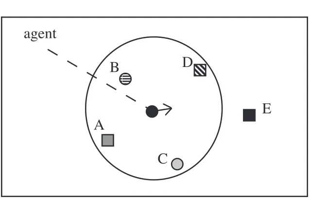
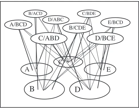
Figure 5 shows an example of this learning process for a simple environment of five
landmarks. From the current view-point, and assuming 360¡ perceptual capability four
landmarks A, B, C, and D are visible for which the agent generates beta-units A/BCD,
B/ACD, C/ABD, D/ABC. Following adequate exploration the network illustrated in
Figure 6 will have been generated.
---
Figure 5 about here.
---
---
Figure 6 about here.
---
Given this network the agent can determine the location of any target landmark when
it is within sight of any group of three others. For instance if cues A, B, and C are visible
and E is required, then the active object units will trigger D/ABC (activating object unit
D) and hence E/BCD to give the egocentric location of the target. The method clearly
generalises to allow the position of any goal site that is encoded with respect to an L-trie
frame to be found. Note that the representation formed by the relational network encodes,
in a direct manner, only the local spatial relations between neighbouring landmarks.
Hence, although individual landmarks may be encoded in multiple local frames, the
memory requirements for any environment is potentially O(n)Ñproportional to the
number of landmarks, rather than O(n2) as would be the case if all global relations
5.3.2 The topology of the relational network
The connectivity of the relational network implicitly defines an adjacency graph of the
topological arrangement of local landmark frames. For instance, the network shown in
figure 6 instantiates the graph shown in Figure 7. The links between nodes in this graph
correspond to the beta-units, the nodes themselves are the L-trie co-ordinate frames (that
are not explicitly represented in the relational network). The topological model of
overlapping frames encoded in the adjacency graph constitutes a more abstract level of
representation which is appropriate for some way-finding procedures (see below).
---
Figure 7 about here.
---
Although the graph shown here has entirely bilateral connections, there is nothing
intrinsically symmetrical about the coding method. For instance, it would be quite
possible to encode the relationship D/ABC and not the reverse A/BCD. This could
happen if the agent, whilst moving through the environment, encodes the positions of
landmarks in front with respect to those it is already passing, but not vice versa. This
property of the mapping mechanism accords with observations of asymmetric spatial
knowledge in humans (see Kuipers, 1982; McNamara, 1992).
5.4 Wayfinding using the relational model
5.4.1 OrientingÑdetermining large-scale spatial relations from a single view-point
The ability to determine the direction and distance to distant locations is a useful
competence that can support behaviours such as orienting toward a remote target, and
moving in the direction of that target with the hope of finding a straight-line route. As has
already been suggested, such estimates do not need to be very accurate in order to be of
considerable useÑit is often sufficient to start out in roughly the right direction and then