White Rose Research Online URL for this paper:
http://eprints.whiterose.ac.uk/912/
Article:
Stokes, C.R. and Clark, C.D. (2002) Are long subglacial bedforms indicative of fast ice
flow? Boreas, 31 (3). pp. 239-249. ISSN 0300-9483
https://doi.org/10.1080/030094802760260355
[email protected] https://eprints.whiterose.ac.uk/ Reuse
Unless indicated otherwise, fulltext items are protected by copyright with all rights reserved. The copyright exception in section 29 of the Copyright, Designs and Patents Act 1988 allows the making of a single copy solely for the purpose of non-commercial research or private study within the limits of fair dealing. The publisher or other rights-holder may allow further reproduction and re-use of this version - refer to the White Rose Research Online record for this item. Where records identify the publisher as the copyright holder, users can verify any specific terms of use on the publisher’s website.
Takedown
If you consider content in White Rose Research Online to be in breach of UK law, please notify us by
CHRIS R. STOKES AND CHRIS D. CLARK
Stokes, C. R. & Clark, C. D. 2002 (September): Are long subglacia l bedforms indicative of fast ice ow?
Boreas, Vol. 31, pp. 239–249. Oslo. ISSN 0300-9483 .
It has been suggeste d that extremely long subglacia l bedforms (e.g. attenuate d drumlins and mega-scal e glacial lineations ) record former areas of fast-owing ice and that bedform elongation ratio is a useful proxy for ice velocity. Despite the availabilit y of much data pertaining to the measurement and analysis of subglacia l bed-forms, these assumption s have rarely been explicitl y addressed in detail. In this paper, we demonstrat e that long subglacia l bedforms (length:widt h ratios¶10:1) are indicativ e of fast ice ow. Using satellite imagery, we mapped over 8000 lineaments associate d with a highly convergen t ow pattern near Dubawnt Lake, District of Keewatin, Canada. This ow pattern is unusual in that it displays a large zone of convergenc e feed-ing into a main ‘trunk’ and then divergfeed-ing towards the inferred ice margin. The ‘bottleneck ’ pattern is taken to record an increase and subsequen t decrease in ice velocity and we analyse d transverse and longitudina l variation s in bedform morphometry. The main trunk of the ow pattern (down-ice of the convergen t zone) is characterize d by mega-scal e glacial lineations of great length (up to 13 km) and high elongatio n ratios (up to 43:1). The down-ice variations in elongation ratio reect exactly what we would expect from a terrestria l ice stream whose velocity increases in the onset zone passes through a maximum in the main trunk and slows down as the ice diverges at the terminus. It is suggeste d that any unifying theory of drumlin formation must be able to account for the association between long subglacial bedform s and fast ice ow, although it is not as-sumed that fast ice ow always produces attenuate d bedforms. A further implication of this work is that many more ice streams may be identied on the basis of attenuate d subglacial bedforms, radicall y altering our views on the ow dynamics of former ice sheets.
Chris R. Stokes (e-mail: [email protected]) , Landscape and Landform Research Group, Department of Geography, The University of Reading, Reading, RG6 6AB, UK; Chris D. Clark (e-mail: c.clark@shef eld. ac.uk), Department of Geography and Shefeld Centre for Earth Observatio n Science , The University of Shefeld, Shefeld, S10 2TN, UK; receive d 16th July 2001, accepte d 19th December 2001.
Elucidating the inuence of ice sheets on the ocean-atmosphere system and predicting their future stability demands an understanding of former ice sheets and their interactions with climate change (MacAyeal 1992; Hughes 1992; Clarket al. 2001). A range of geomor-phological evidence is available to reconstruct the spatial extent and thickness of palaeo-ice sheets (e.g. terminal moraines and trimlines), but the distribution of subglacial bedforms is arguably the most informative evidence, providing information regarding their ow patterns and position of ice divides (Boulton & Clark 1990a, b; Kleman & Ha¨ttestrand 1999; Clark et al. 2000). It has also been recognized that specic subglacial bedforms can be attributed to certain condi-tions at the ice-bed interface and mapping them at the ice-sheet scale has uncovered the dynamic nature of palaeo-ice-sheet behaviour and associated changes in their basal thermal regime (e.g. Boulton & Clark 1990a; Kleman & Ha¨ttestrand 1999).
The geometry of subglacial bedforms may reveal something about the processes acting at the ice-bed interface. Despite no general consensus on the origin of drumlins, for example, many workers would agree that the diversity in their morphometry reects the large variability of controlling factors (e.g. sediment avail-ability, ice velocity, etc.). However, clear-cut relation-ships have often remained elusive. In a comprehensive
review of the drumlin literature, Menzies (1979) commented that ‘many relationships that have been suggested in the past remain untested and therefore exist only as hypothetical statements’. Here, we examine the assumption that attenuated drumlins and mega-scale glacial lineations are indicative of fast ice ow. It has been argued that these bedforms record former areas of fast owing ice (Clark 1993) and that bedform elonga-tion ratio is a useful proxy for ice velocity (e.g. Hart 1999). Despite the availability of data pertaining to the measurement and analysis of subglacial bedforms, these hypotheses have rarely been rigorously tested.
Long subglacial bedforms and fast ice ow:
a brief history
Much of the early work on drumlin morphometry established the view that they were an equilibrium form produced by the action of overriding ice. It was logical, therefore, that faster ice velocities and/or uni-directional ice ow would produce more streamlined features and several authors noted this apparent rela-tionship (e.g. Alden 1905; Wright 1912; Hollingworth 1931; Charlesworth 1957; Chorley 1959).
Quantitative work by Heidenreich (1964) on the
Peterborough drumlin eld (Ontario, Canada) found that drumlin length and width tend to increase in a predictable manner until a critical width is reached. Thereafter, only an increase in length is observed. He speculated that the increase in elongation ratio after a critical width is likely to be governed by sediment availability and/or ice velocity. In contrast, Trenhaile’s (1971) analysis of six drumlin elds in southern Ontario found no evidence that the width:length ratio is dependent upon width attaining an equilibrium value after which only length continues to increase.
Other workers have argued that the constancy of ow direction is likely to be a more signicant factor than ice velocity in controlling the elongation of a bedform (Doornkamp & King 1971; Mills 1987). Mills (1987) presented evidence which showed that high elongation ratios occur where the standard deviation of drumlin orientation is least (i.e. parallel bedforms), arguing that longer drumlins tend to occur along the central axis of glacier lobes, where the ice-ow direction is more constant (cf. Charlesworth 1957). It should be remem-bered, however, that the central zone of a lobe is likely to be owing faster than those areas nearer the lateral margins.
Variations in drumlin elongation ratios have also been explained in terms of variations in ice velocity and thickness. Jauhiainen (1975) analysed several drumlin elds in north Central Europe and concluded that the large variability in elongation ratios both within and between individual drumlin elds can be explained by variations in ice pressures. This work was criticized by Menzies (1979) because it failed to recognize the importance of the differing properties of the underlying sediment. For example, in the Woodstock drumlin eld, Ontario, Canada, Piotrowski (1987) found that smaller, more elongate drumlins are comprised mainly of ner grained material, whereas the larger more ‘oval’ drumlins are comprised of generally coarser grained till. Rose (1987) viewed these ‘lithological’ factors as independent controls which introduce variability to what would otherwise be a relatively uniform subglacial bedform continuum where longer bedforms are pro-duced by thicker, faster ice ow.
More recent work has invoked the activity of palaeo-ice streams to explain attenuated subglacial bedforms and the observed variations in elongation ratios within specic drumlin elds. Dyke & Morris (1988) reported a zonation of drumlin sizes within a convergent erratic dispersal plume associated with ice stream activity on Prince of Wales Island, Arctic Canada. Drumlins within the dispersal plume were larger near its axis, where presumably ow was fastest. Smaller drumlins were found in the upstream convergent zone and towards the margins of the inferred ice stream, reecting the expected patterns in ice velocity.
Mitchell (1994) discovered similar relationships in the western Pennines of northern England. He found that shorter drumlins occurred in close approximation to
inferred ice divides and the more elongated bedforms depicted zones of convergent (and presumably faster) ice ow. Mitchell (1994) argued that drumlin elonga-tion records the former driving stresses of the ice sheet (i.e. higher stresses produce longer bedforms) but that the resistance of the bed to deformation is also important.
If subglacial till deformation is an important control on the fast ow of some ice streams (cf. Alley et al. 1986), then the deforming material might be attenuated in the downstream direction. However, if pervasive deformation is inhibited, some workers have suggested that the development of elongated bedforms may be hindered. This scenario was invoked by Boyce & Eyles (1991), who suggested that decreased duration of subglacial sediment deformation was responsible for a downstream decrease in drumlin elongation ratio in the Simcoe Lobe of the Laurentide Ice Sheet. A similar downstream decrease in drumlin elongation ratio characterizes the M’Clintock Channel palaeo-ice stream bed, Victoria Island, Arctic Canada (Clark & Stokes 2001). They argued that it is related to a reduction in the availability of sediment for subglacial deformation immediately prior to ice stream shut-down. Several arguments were given by Clark (1993) to suggest why mega-scale glacial lineations (up to 70 km in length) are most likely to record the location of former ice streams. Assuming point initiation of features and their downstream attenuation, long bed-forms may arise from high velocities over short time-scales or slower velocities over longer timetime-scales. As more evidence is being uncovered which suggests that former ice sheets changed their volume and area rapidly, the latter option becomes less likely (cf. Andrews et al. 1983; Boulton & Clark 1990a, b; MacAyeal 1993). This led Stokes & Clark (1999) to postulate highly attenuated bedforms (elongation ratios
>10:1) as a specic geomorphological criterion for
identifying palaeo-ice streams. Hart (1999) performed a more quantitative analysis to substantiate this proposi-tion by matching variaproposi-tions in elongaproposi-tion ratios across the Lake Cayuga area of the New York State drumlin eld with the lateral velocity patterns across two contemporary ice streams. This lateral variation in elongation ratios, whereby longer bedforms occur towards the central axis of ow within a lobe/ice stream, is well documented (e.g. Dyke & Morris 1988; Mitchell 1994) and provides strong evidence that bedform attenuation is related to ice velocity.
To summarize, three main factors have been advo-cated to account for attenuated bedforms both within and between drumlin elds:
1. Long duration of ice ow combined with constancy of direction.
2. High ice velocities.
Methodology
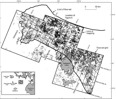
Our study focuses on a distinctive ow pattern trending in a northwesterly direction, north of Dubawnt Lake, District of Keewatin, Canada (Fig. 1). This ow-set has been mapped previously (e.g. Bird 1953; Lee 1959; Shilts et al. 1979; Aylsworth & Shilts 1989a, b) and is also represented on the Glacial Geological Map of Canada (Prestet al. 1968). Aylsworth & Shilts (1989b) speculated that the ow pattern could have been produced by an ice stream, and Boulton & Clark (1990b) attributed it to a late glacial event (c. 10 000 yrs BP) related to a southeast shift in the Keewatin Ice Divide. Kleman & Borgstro¨m (1996) identied the ow pattern as a type landscape for a ‘surge fan’ in their
glaciological inversion model for reconstructing former ice sheets.
[image:4.533.36.503.223.621.2]Of most importance to this investigation is the unusual shape of the ow pattern (Fig. 1). It can be seen that it exhibits a highly convergent zone up-ice that feeds into a narrow ‘trunk’ and then diverges again towards the inferred ice-sheet margin (Fig. 1). We take this ‘bottleneck’ pattern to reect ice velocities that increase down-ice, reach a maximum in the narrow trunk and then decrease again towards the lobate terminus. Furthermore, the ow-set is in no way topographically controlled, adding to the evidence that the ow convergence is attributable to an increase in ice velocity and was not simply steered by underlying topography (Stokes 2000). The shape of this ow
pattern provides an ideal template for testing the assumption that long bedforms are indicative of fast ice ow. If this assumption is valid, then we would expect to nd more elongated bedforms in the narrow trunk of the ow-set and smaller bedforms up-ice and down-ice.
Satellite imagery (Landsat MSS; spatial resolution 80 m) was geocoded and processed to highlight geo-morphology and over 11 000 lineaments were digitized on screen, mainly from the southern half of the ow-set (cf. Clark 1997 for review of methodology). Lines were digitized representing the long axis of the bedform and the following lineament parameters were measured: length and width (used to calculate elongation ratio: length/width), orientation, and parallel conformity (standard deviation of orientation for a sample of lineaments). In addition, the surface area of each bedform was calculated by approximating it with an ellipsoid so that the degree of packing (surface area of bedforms per unit area) could be calculated in addition to density (number of bedforms per unit area).
Bedform characteristics of the Dubawnt Lake
ow-set
All of the lineaments that were identied as part of the Dubawnt Lake ow-set are shown in Fig. 1 with the inferred palaeo-ow lines, gridded into ow corridors at 20 km intervals. In the centre of the ow-set, lineaments were binned into 20 by 20 km grid squares parallel to ice ow. Immediately up-ice and down-ice the ow corridors were broadened to reect the convergence and divergence of the former ow lines. The ow-set is reconstructed as having a maximum length of around 450 km. In the convergent ‘onset zone’ (c. 0–100 km down-ice) the ow-set approaches widths of 305 km and this narrows into the main ‘trunk’, which maintains
a fairly constant width of around 140 km. Towards the inferred margin, the lobate terminus broadens to around 190 km. The surface area of the ow-set is estimated to be around 72 000 km2.
The geology of the ice sheet bed is characteristic of the Canadian Shield, comprised of granitic gneiss interrupted in places by sedimentary and volcanic strata (Aylsworth & Shilts 1989a). The basement rocks (e.g. granites) can be broadly described as ‘hard rock’, largely resistant to glacial erosion. In contrast, the sedimentary outcrops were more friable, yielding abundant glacial debris which probably inuenced the glacier dynamics (Aylsworth & Shilts 1989a).
Elevations across the ice-sheet bed (taken from 1:250 000 topographic maps; contour interval 20 m) range from 170 to 250 m in the onset zone, lowering to 150 to 200 m in the main trunk of the ow-set before climbing to between 200 and 300 m towards the terminus. Any topographic control on the ow pattern or its margins is negligible given its large size (Stokes 2000).
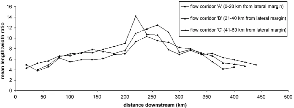
The down-ice variation in mean bedform length for each of the three ow corridors A, B and C is shown in Fig. 2. A distinctive pattern reveals that bedforms are longest approximately half way down the ow-set between around 200 and 280 km down-ice. The linea-tions increase from an average length of 750 m (maxi-mum 9636 m) in the onset zone to an average of 4000 m (maximum 12 248 m) in the main trunk (between 100 and 300 km down-ice), after which they steadily decrease in length towards the terminus.
[image:5.533.38.503.488.658.2]Down-ice variations in average lineament width are shown in Fig. 3. It can be seen that the peaks in average width do not coincide with the peaks in average length. Average widths of 400 m (maximum 990 m) peak between 100 and 160 km down-ice and this indicates that the longest bedforms are not necessarily the widest bedforms. Rather, an increase in streamlining is observed around 200 km down-ice. This is conrmed
by plotting the down-ice variation in average elongation ratio for each of the three ow-corridors (Fig. 4).
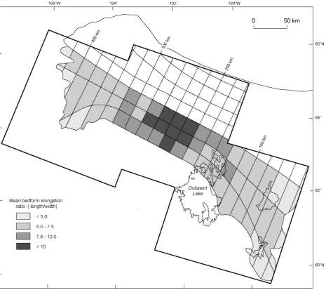
Average elongation ratios (length/width) peak between 200 and 300 km down-ice (Fig. 4). Here, the bedforms comprise mega-scale glacial lineations (cf. Clark 1993) of great length (up to 13 km) and high elongation ratios (up to 48:1). Fig. 5 is a map of mean elongation ratios for the southern half of the ow-set which illustrates how the bedforms become more attenuated immediately down-ice of the ow conver-gence. Fig. 6 is a Landsat ETM‡image of a sample of these bedforms from the centre of the ow-set. They exhibit a remarkable degree of parallel conformity with their neighbours and over an area of 720 km2 in the main trunk, the standard deviation of lineament orientation does not exceed 3.8°.
In addition, bedforms are generally longer, wider and more elongated towards the central axis of the ow-set (comparing results between ow corridors A, B and C
on Figs. 2–4). Lineaments also tend to become more closely packed together and occupy greater surface areas towards the central axis of the ow-set (c. 240 km down-ice). Fig. 7 is a map of bedform packing (percentage lineament surface area per unit area) for the southern half of the ow-set. It can be seen that the pattern resembles that of bedform elongation ratio, indicating that lineaments not only get longer in the narrowest part of the ow-set, but also become more closely packed together and occupy greater surface areas.
Discussion
Are long bedforms (attenuated drumlins and mega-scale glacial lineations) indicative of fast ice ow?
The attenuated drumlins and mega-scale glacial
[image:6.533.36.501.38.206.2]linea-Fig. 3.Down-ice variations in mean bedform width along the Dubawnt Lake ow-set. See Fig. 1 for ow corridor location.
[image:6.533.33.504.474.647.2]tions from the Dubawnt Lake ow-set bed could have been formed by (i), rapid ice velocities, (ii) slow ice velocities over a long time period, or (iii), arise from variations in sediment characteristics beneath the ice sheet.
Given the strongly convergent ow pattern, the abrupt southern margin of the ow-set (a characteristic of ice streams), and the fact that neither was controlled by topography (cf. Kleman & Borgstro¨m 1996; Stokes 2000), we reject the idea that the ow-set was produced by slow ice velocities over a long time period. In addition, we argue that the parallel conformity of the bedforms, which gives the appearance of a ridge/groove structure, can only have been generated by rapid ice ow (see Fig. 6). If the ow pattern were produced over
longer time periods we would expect lineaments to display a variety of orientations, arising from uctua-tions in ow direcuctua-tions, producing a time-transgressive or ‘smudged’ imprint (cf. Clark 1999). The super-imposition of the Dubawnt Lake ow-set across older ow patterns also conrms that it was a relatively short-lived event prior to deglaciation (cf. Boulton & Clark 1990b; Kleman & Borstro¨m 1996).
[image:7.533.38.504.228.641.2]The alternative, therefore, is that the attenuated bedforms and mega-scale glacial lineations resulted from variations in sediment characteristics rather than from enhanced ice ow. It is difcult to reconcile this hypothesis with the evidence in favour of fast ice ow (i.e. abrupt lateral margin, convergent ice ow), but we acknowledge that sedimentary characteristics beneath
the ow-set were important. Aylsworth & Shilts (1989a) commented that the most spectacular stream-lined drumlins in the study area occur immediately down-ice of sedimentary basins. The Thelon Sedimen-tary Basin was particularly susceptible to glacial erosion and produced relatively large volumes of friable sediment eroded from poorly consolidated sandstone outcrops (Aylsworth & Shilts 1989a). This basin underlies a large part of the ow-set trunk, but signicantly also spans a large area outside the inferred margin to the south. If sedimentary characteristics were the only control on bedform dimension, then it is difcult to explain why long bedforms were not generated on the part of the sedimentary basin which lies outside the southern margin. No elongated bed-forms are found here, despite the availability of sediment. We favour an interpretation that the erodible sediments encouraged fast ice ow through the area, but that ice velocity was the primary control on their exceptional down-ice attenuation.
In summary, long bedforms are indicative of fast ice ow within the main trunk of the Dubawnt Lake ow pattern. Extrapolating this reasoning to other areas with relatively uniform geology and topography, we suggest that when highly attenuated bedforms display a high
degree of parallel conformity and highly convergent, coherent ow patterns, fast ice ow can be invoked.
Does fast ice ow always produce long bedforms?
We do not propose that fast ice ow will always produce attenuated drumlins and mega-scale glacial lineations. For example, Evans (1996) suggested that topographic ice streams (i.e. those ice streams whose location is controlled by a bedrock trough) are erosional agents, sliding and plucking their beds. Marshallet al. (1996) also argued that these ice streams may leave little or no landform assemblages. Clearly, the degree of bedform development and attenuation depends on the ow mechanism and the degree of coupling between the ice and the substrate beneath. Fast ice ow can be achieved by rapid basal sliding or by the thermally enhanced deformation of the basal ice layers (Ikenet al. 1993), neither of which may necessarily produce streamlined subglacial bedforms. When long bedforms are present, however, we suggest fast ice ow is the most likely explanation.
Is elongation ratio a useful proxy for ice velocity?
It has been argued that ice velocity and duration of ow are the primary controls on the elongation of a stream-lined bedform (Clark 1993, 1994). Assuming these landforms are initiated at a point, the nal length of a bedform is taken to be a function of the ice velocity and ow duration (cf. Clark 1993). If we assume complete coupling of the ice sheet to the underlying substrate, an ice sheet owing at 15 m yr¡1for 10 years would be capable of moulding a bedform of 150 m in length. It becomes clear then, that highly attenuated bedforms, such as mega-scale glacial lineations, may be produced by either rapid ice ow over a short time, or slower ice ow over a longer duration. The weight of evidence in favour of rapidly changing ice-sheet congurations would appear to suggest that stable ow patterns were not common in former ice sheets (cf. Andrewset al. 1983; Boulton & Clark 1990a, b; MacAyeal 1993). Therefore, we infer that long bedforms are more readily explained by episodes of fast ice ow, especially where we have reliable indicators of ice stream activity, such as might be the case with the Dubawnt Lake ow pattern.
[image:8.533.33.257.37.288.2]It could be argued that bedforms do not always arise from point initiation. Another alternative is linear initiation, whereby the length of the lineation is unrest-ricted by the velocity-duration product. If stress patterns within the basal ice are aligned in longitudina l zones, little forward ice motion may be required to produce lineations. Under these hypothetical conditions, land-forms of great length may be formed under relatively slow owing ice. A till squeeze theory was developed by Stalker (1960), who suggested that saturated till may be squeezed or ‘pressed up’ into subglacial cavitites at
the base of the ice sheet which are aligned parallel to the ice-ow direction. However, as Menzies (1979) noted, while the theory appears sound the scale of the process remains unknown. We reject this hypothesis because it is difcult to conceptualize a plausible process of ice dynamics that can produce this effect over whole drumlin elds.
A more serious concern which undermines our assumption of the velocity-duration product is that of basal uncoupling. Put simply, if the base of the ice sheet is not strongly coupled to the underlying sediment (i.e. slides across the surface, perhaps aided by a thin water lm), then the length of the subglacial bedform is not necessarily proportional to ice velocity. It is quite
[image:9.533.38.504.226.641.2]conceivable that an increase in velocity may be asso-ciated with a decrease in basal coupling and, therefore, no increase in bedform length. In this case, elongation ratio is a manifestation of the coupling at the ice-bed interface and till rheology, and is not related to velocity. This makes it difcult to make quantitative estimates of ice velocity from bedform dimensions. However, when long bedforms are produced, we can assume that basal uncoupling will not vary drastically within a ow-set and some qualitative relationships may be found. This is the case for the Dubawnt Lake ow-set, where down-ice variations in elongation ratios (Fig. 5) support the hypothesis that bedform attenuation is indicative of ice velocity.
Although we have no contemporary analogues from which to compare velocity, the variations in elongation ratio within the Dubawnt Lake ow-set reect exactly what we would expect from a terrestrial ice stream, the velocity of which increases in the onset zone, passes through a maximum in the main channel and slows down as the ice diverges towards the terminus. Further evidence in favour of ice-stream activity is the abrupt southern margin to the bedform pattern which we interpret as a former shear margin (cf. Stokes 2000).
Fig. 5 also indicates that bedforms tend to be more elongated towards the central axis of the ow-set away from the southern lateral margin. This concurs with observations on contemporary ice streams, where side drag is imposed by the slower moving ice outside the margins (Whillanset al. 1993). Making inferences from internal variations of elongation ratio within an iso-chronous ow pattern appears to be valid, but compar-ing elongation ratios between separate ow-sets may not be so informative.
Another potential problem when estimating ice velocity from elongation ratios is that of sediment availability. If we assume the point initiation mechan-ism, then areas of abundant sediment are likely to become more attenuated simply because more sediment can be carried down-ice. This relationship becomes even more complex when considering the deforming bed model of drumlin formation, which allows indivi-dual drumlins to become ‘uprooted’ and migrate down-ice (Boulton 1987; Hindmarsh 1998). Clearly, further work is required on till rheology, basal uncoupling and the degree of cumulative strain at the ice/bed interface before elongation ratios can be extrapolated to provide a quantitative estimate of ice velocity. However, we propose that, at least qualitatively, they can be used as a relative indicator of strain rate, velocity and degree of bed coupling.
Evidence from the margins of contemporary ice sheets
If we were able to view attenuated drumlins and mega-scale glacial lineations at the foregrounds of contem-porary ice streams we could rmly establish the link between their occurrence and fast ice ow. Unfortu-nately, contemporary ice streams terminate in marine environments, but recent technological advances over the last few decades have allowed us to view their submarine ‘footprints’. These investigations provide strong evidence to link fast ice ow with attenuated drumlins and mega-scale glacial lineations.
Retreat of the West Antarctic Ice Sheet from the edge of the continental shelf during the Holocene was almost certainly facilitated by the Siple Coast ice streams whose former tracks have recently been delineated beneath the Ross Ice Shelf (Bindschadler et al. 1998). Here, geophysical investigations (Shipp & Anderson 1997; Shippet al. 1999) identied lineations in excess of 20 km in length and attenuated drumlins (lengths
3–8 km, widths 0.5–0.75 km). Shipp et al. (1999) suggested that these features represent the rst marine discovery of Clark’s (1993) mega-scale glacial linea-tions. Canals et al. (2000) have also found submarine landforms analogous to mega-scale glacial lineations inferred to have been sculptured by a large ice stream which drained an expanded Antarctic Peninsula Ice Cap during the Last Glacial Maximum. These features are similar in scale and character to terrestrial mega-scale glacial lineations, but show uninterrupted continuity along their 100 km length. Canalset al. (2000) refer to this sinuous track of grooves and ridges as a ‘bundle structure’ and suggest that it may be the largest ice-ow-related landform ever identied. These ndings considerably strengthen the hypothesis that attenuated drumlins and mega-scale glacial lineations are indica-tive of fast ice ow.
The discovery by Canalset al. (2000) raises a number of interesting questions with regard to the actual processes that facilitated fast ice ow and produce the observed mega-scale glacial lineation of ridges and grooves. It could be argued that it is unlikely that point initiation in the down-ice direction could account for their exceptional length and sinuosity (up to 100 km) and linear initiation is unlikely (see arguments above). One possible explanation is that keels (or ‘bumps’) in the base of an ice sheet plough through unconsolidated sediments to produced the observed grooves (see Tulaczyk et al. 2001). Ploughing by ice keels may be a valid mechanism by which terrestrial mega-scale glacial lineations were produced. The remarkable length and parallel conformity of the bedforms from the Dubawnt Lake ice stream largely resembles a ridge/ groove structure (Fig. 6). If this is the case, then attenuated bedforms produced by this mechanism are still the product of an ice velocity duration product, i.e. a rapidly moving ice keel will produce a longer groove than a slowly moving keel. It still holds true that extremely long bedforms would be indicative of fast ice ow. Clearly, methods are needed to conrm or falsify this, as yet, qualitative model of bedform production. One such method would be to develop predictions of the geomorphology that should arise from such a mechan-ism and compare it to the actual geomorphology found on exposed ice sheet beds.
Conclusions
In the main trunk of the ow-set (between 100 and 300 km down-ice) the bedforms comprise attenuated drumlins and mega-scale glacial lineations which are characterized by great lengths (up to 13 km), and elongation ratios are some of the highest ever docu-mented on land (up to 48:1). The remarkable degree of parallel conformity with neighbouring bedforms pro-vides further evidence that they were generated rapidly and gives the appearance of a ridge/groove structure.
The down-ice variations in elongation ratio reect exactly what we would expect from a terrestrial ice stream, the velocity of which increases in the onset zone, passes through a maximum in the main channel and slows down as the ice diverges towards the terminus. Elongation ratios tend to increase towards the central axis of the ow-set and this concurs with observations on contemporary ice streams, where the slower moving ice beyond the lateral margins imposes side drag.
Transverse variations in elongation ratios across drumlin elds are well documented in the literature (e.g. Dyke & Morris 1988; Hart 1999) and provide strong evidence that bedform attenuation is related to ice velocity. In this paper, we provide evidence of longitudina l variations in elongation ratio, which also supports this hypothesis. The observed ow conver-gence (and presumably increased ice velocity) is matched by a concomitant increase in bedform elonga-tion ratio and we see no other explanaelonga-tion for the variations in elongation ratio other than those related to ice velocity.
We conclude that highly attenuated subglacial bed-forms (mega-scale glacial lineations; length:width ratios ¶10:1) are indicative of fast ice ow, although we do not assume that fast ice ow will always produce them. It is also suggested that under conditions of uniform geology and topography, bedform elongation ratio provides a qualitative proxy for ice velocity, strain rate and basal coupling. It is suggested that using bedform dimensions to make a quantitative estimate of ice velocity may not be entirely valid because of com-plications arising from variations in basal uncoupling.
Any unifying theory of drumlin formation must be able to account for the relationship between long bedforms and fast ice ow. A further implication of this work is that many more ice streams could be identied on the basis of highly attenuated bedforms, radically altering our views on the ow dynamics and stability of former ice sheets.
Acknowledgements . – We thank Slawek Tulaczyk and Johan Kleman, whose constructiv e comments improved this manuscript . We are also grateful to Heather Browning, Department of Geogra-phy, the University of Reading, who drew the gures. The paper was presente d at the 6th Internationa l Drumlin Symposium in Torun´, Poland, June 2001. CRS is grateful to the Landscape and Landform Research Group (Department of Geography) and the University of Reading Travel Grant Sub-Committee for providing funds to attend the conference .
References
Alden, W. C. 1905: The drumlins of southeaster n Wisconsin.United States Geologica l Survey Bulletin 273, 46 pp.
Alley, R. B., Blankenship, D. D., Bentley, C. R. & Rooney, S. T. 1986: Deformation of till beneath Ice Stream B, West Antarctica .
Nature 322, 57–59.
Andrews, J. T., Shilts, W. W. & Miller, G. 1983: Multiple deglaciation s of the Hudson Bay Lowlands, Canada, since the deposition of the Missinaibi (last i/g?) formation. Quaternary Research 19, 18–37.
Aylsworth, J. M. & Shilts, W. W. 1989a: Glacial features around the Keewatin Ice Divide: Districts of MacKenzie and Keewatin.
Geologica l Survey of Canada Paper 88-24, 21 pp.
Aylsworth, J. M. & Shilts, W. W. 1989b: Bedforms of the Keewatin Ice Sheet, Canada.Sedimentar y Geology 62, 407–428.
Bindschadler , R. A., Alley, R. B., Anderson, J., Shipp, S., Borns, H., Fastook, J., Jacobs, S., Raymond, C. F. & Shuman, C. A. 1998: What is happenin g to the West Antarctic Ice Sheet? EOS, Transactions , American Geophysica l Union 79, 264–265. Bird, J. B. 1953: The glaciatio n of central Keewatin, Northwest
Territories , Canada.American Journal of Science 251, 215–230. Boulton, G. S. 1987: A theory of drumlin formation by subglacia l
sediment deformation .InMenzies, J. & Rose, J. (eds.):Drumlin Symposium,25–80. A. A. Balkema, Rotterdam.
Boulton, G. S. & Clark, C. D. 1990a: A highly mobile Laurentide Ice Sheet revealed by satellite images of glacial lineations . Nature 346, 813–817.
Boulton, G. S. & Clark, C. D. 1990b: The Laurentide Ice Sheet through the last glacial cycle: the topograph y of drift lineation s as a key to the dynamic behaviou r of former ice sheets.Transactions of the Royal Society of Edinburgh : Earth Science s 81, 327–347. Boyce, J. I. & Eyles, N. 1991: Drumlins carved by deforming till
streams below the Laurentide Ice Sheet.Geology 19, 787–790. Canals, M., Urgeles, R. & Calafat, A. M. 2000: Deep sea-oor
evidence of past ice streams off the Antarctic Peninsula.Geology 28, 31–34.
Charlesworth, J. K. 1957:The Quaternar y Era. 1700 pp. Edward Arnold, London.
Chorley, R. J. 1959: The shape of drumlins.Journal of Glaciology 3, 339–344.
Clark, C. D. 1993: Mega-scal e glacial lineation s and cross-cuttin g ice-ow landforms .Earth Surface Processes and Landforms 18, 1–29.
Clark, C. D. 1994: Large-scal e ice-moulding : a discussion of genesis and glaciouvial signicance.Sedimentar y Geology 91, 253–268. Clark, C. D. 1997: Reconstructin g the evolutionar y dynamics of former ice sheets using multi-tempora l evidence , remote sensing and GIS.Quaternar y Science Reviews 16, 1067–1092.
Clark, C. D. 1999: Glaciodynami c context of subglacia l bedform generation and preservation .Annals of Glaciolog y 28, 23–32. Clark, C. D., Knight, J. K. & Gray, J. T. 2000: Geomorphologica l
reconstructio n of the Labrador Sector of the Laurentide Ice Sheet.
Quaternary Science Reviews 19, 1343–1366.
Clark, C. D. & Stokes, C. R. 2001: Extent and basal characteristic s of the M’Clintock Channel Ice Stream. Quaternar y Internationa l
86/1, 81–101.
Clark, P. U., Marshall, S. J., Clarke, G. K. C., Hostetler, S. W., Licciardi, J. M. & Teller, J. T. 2001: Freshwater forcing of abrupt climate change during the Last Glaciation .Science 293, 283–287. Doornkamp, J. C. & King, C. A. M. 1971Numerical Analysis in
Geomorphology. 372 pp. Edward Arnold, London.
Dyke, A. S. & Morris, T. F. 1988: Drumlin elds, dispersa l trains, and ice streams in Arctic Canada.Canadian Geographe r 32, 86– 90.
Evans, I. S. 1996: Abraded rock landforms (whalebacks ) developed under ice streams in mountain areas.Annals of Glaciology 22, 9– 15.
in the geological record: a discussion .Annals of Glaciology 28, 59–67.
Heidenreich, C. 1964: Some observation s on the shape of drumlins.
Canadian Geographe r 8, 101–107.
Hindmarsh, R. C. A. 1998: Drumlinisatio n and drumlin-formin g instabilities : viscous till mechanisms.Journal of Glaciolog y 44, 293–314.
Hollingworth , S. E. 1931: The drumlins of Edenside and the Solway Basin.Quarterly Journal of the Geologica l Society 87, 324–359. Hughes, T. 1992: Abrupt climatic change related to unstable ice-sheet dynamics: toward a new paradigm. Palaeogeography, Palaeoclimatology , Palaeoecolog y 97, 203–234.
Iken, A., Echelmeyer, K., Harrison, W. & Funk, M. 1993: Mechan-isms of fast ow in Jakobshavn s Isbræ, West Greenland : Part 1. Measurement s of temperatur e and water level in deep boreholes.
Journal of Glaciology 39, 15–25.
Jauhiainen , E. 1975: Morphometri c analysis of drumlin elds in northern Central Europe.Boreas 4, 219–230.
Kleman, J. & Borgstro¨m, I. 1996: Reconstructio n of palaeo-ic e sheets: the use of geomorphologica l data.Earth Surface Processes and Landforms 21, 893–909.
Kleman, J. & Ha¨ttestrand , C. 1999: Frozen-bed Fennoscandia n and Laurentide Ice Sheets during the last glacial maximum.Nature 402, 63–66.
Lee, M. A. 1959: Surcial geology of southern District of Keewatin and the Keewatin ice divide, Northwest Territories .Geological Survey of Canada Bulletin 51, 1–42.
MacAyeal, D. R. 1992: Irregula r oscillation s of the West Antarctic ice sheet.Nature 359, 29–32.
MacAyeal, D. R. 1993: Binge/purge oscillation s of the Laurentide Ice Sheet as a cause of the North Atlantic’s Heinrich events.
Paleoceanograph y 8, 775–784.
Marshall, S. J., Clarke, G. K. C., Dyke, A. S. & Fisher, D. A. 1996: Geologic and topographi c controls on fast ow in the Laurentide and Cordillera n Ice Sheets.Journal of Geophysical Research 101, 17827–17839.
Menzies, J. 1979: A review of the literatur e on the formation and location of drumlins.Earth Science Reviews 14, 315–359. Mills H. H. 1987: Morphometry of drumlins in the northeaster n and
northcentra l USA. In Menzies, J. & Rose, J. (eds.): Drumlin Symposium,131–147. A. A. Balkema, Rotterdam.
Mitchell, W. A. 1994: Drumlins in ice sheet reconstructions , with
referenc e to the western Pennines, northern England.Sedimentary Geology 91, 313–331.
Piotrowski, J. A. 1987: Genesis of the Woodstoc k drumlin eld, southern Ontario, Canada.Boreas 16, 249–265.
Prest, V. K., Grant, D. R. & Rampton, V. N. 1968:Glacial Map of Canada. Map 1253A, Geological Survey of Canada.
Rose, J. 1987: Drumlins as part of a glacier bedform continuum .In
Menzies, J. & Rose, J. (eds.):Drumlin Symposium ,103–116. A. A. Balkema, Rotterdam.
Shilts, W. W., Cunningham , C. M. & Kaszycki, C. A. 1979: Keewatin Ice Sheet – re-evaluatio n of the traditiona l concept of the Laurentide Ice Sheet.Geology 7, 537–541.
Shipp, S. & Anderson, J. B. 1997: Lineations on the Ross Sea continenta l shelf, Antarctica .InDavies, T. A., Bell, T., Cooper, A. K., Josenhans , H., Polyak, L., Solheim, A., Stoker, M. S. & Stravers, J. A. (eds.): Glaciated Continental Margins, 54–55. Chapman and Hall, London.
Shipp, S., Anderson, J. & Domack, E. 1999: Late Pleistocene– Holocene retreat of the West Antarctic Ice-Sheet system in the Ross Sea: Part 1 – Geophysical results. Geological Society of America Bulletin 111, 1486–1516.
Stalker, A. 1960: Ice-presse d drift forms and associate d deposits in Alberta.Geological Survey of Canada Bulletin 57, 1–38. Stokes, C. R. 2000:The Geomorpholog y of Palaeo-ice Streams:
Identication, Characterisatio n and Implication s for Ice Stream Functioning. Ph.D. dissertation , University of Shefeld, 250 pp. Stokes, C. R. & Clark, C.D. 1999: Geomorphologica l criteria for
identifyin g Pleistocen e ice streams.Annals of Glaciology 28, 67– 75.
Stokes, C. R. & Clark, C. D. 2001: Palaeo-ice streams.Quaternary Science Reviews 20, 1437–1457.
Trenhaile, A. S. 1971: Drumlins: Their distribution , orientation , and morphology.Canadian Geographe r 15, 113–126.
Tulaczyk, S. M., Scherer, R. P. & Clark, C. D. 2001: A ploughin g model for the origin of weak tills beneath ice streams: a qualitativ e treatment.Quaternary Internationa l 86/1, 59–70.
Whillans, I. M., Jackson, M. & Tseng, Y.-H. 1993: Velocity pattern in a transect across Ice Stream B, Antarctica . Journal of Glaciology 39, 562–572.
Wright, W. B. 1912: The drumlin topograph y of South Donegal.