Article
Highway alignment optimization: An integrated BIM
and GIS approach
Linlin Zhao 1, Zhansheng Liu 1* and Jasper Mbachu 2,
1 Beijing University of Technology, Beijing, China; [email protected] 2 Bond University, Gold Coast, Australia; [email protected]
* Correspondence: [email protected];
Abstract: Highway alignment is an essential part of the highway planning and design phase. The isolation of highway alignment from the surroundings delays the planning process. This study therefore proposes a model that integrates building information modelling (BIM) and geographic information science (GIS) capabilities to manage the highway alignment in the context of a larger landscape. To support the integration, semantic web technologies are used to integrate data on a semantic level. The method facilitates highway alignment optimization by incorporating visualization, simulation, and analysis into the planning and design phase. 3D visualization of the proposed project can help reduce design errors and miscommunication, which, in turn, reduces project risk. Moreover, providing geological analysis helps to identify geohazards. In addition, based on the genetic algorithms, the optimal alignment can be produced. The proposed method provides future opportunities for users to have organized, reliable and dynamic ways to manage the project during construction.
Keywords: BIM; GIS; Highway alignment; optimization
1. Introduction
Highways are a fundamental component of human civilization, and highway networks are the backbone of modern society [1]. The alignment of highways plays an important role in any highway design project [2]. Once the highway alignment has been settled, other critical aspects and related costs, such as construction costs and user costs, are largely determined. In reality, highway alignments are subject to many code and external restrictions, and efforts should be made to discover optimal design alternatives.
Unlike building structures, on which the surrounding geometrical context has little effect, civil infrastructure projects are vulnerable to every little change in the terrain. Civil infrastructure projects are connected complex networks that span vast geographic areas. The proposed project is motivated by the existing project and the surrounding context. The optimum design should consider these interdependent networks. The design of a highway requires a large amount of data and information about the surrounding environment and geological conditions. The isolation of the geotechnical analysis from the infrastructural design also delays the planning process.
The current planning design process concerns only the highway itself. Additional related aspects and geotechnical conditions are not considered, and the process is time-consuming, inefficient and costly. To solve this problem, this study proposes an integrated BIM and geographic information science (GIS) model for enhancing the performance and automation of the civil infrastructural planning and design by allowing data exchange and incorporating geotechnical analysis into the planning and design process. Different data formats, such as industry foundation class (IFC) and GML, can integrate with both as the adoption of semantic web technologies.
The application of this model facilitates highway design by providing a cross-discipline approach to close the gap between the infrastructural and geotechnical planning processes. Moreover, the visualization of appropriate geological data allows users to detect potential hazards
and call for corrective methods. In addition, the proposed model generates a more accurate calculation of work quantity compared with traditional methods. The optimization algorithm (genetic algorithm [GA]) is also adopted to provide a scientific basis for an optimal option.
This paper is divided into six sections. Following the introduction, Section 2 provides a literature review. Section 3 illustrates the proposed model. Section 4 uses a case example to validate the feasibility of the proposed approach. Section 5 provides a brief result discussion. Section 6 concludes the paper.
2. Literature Review
2.1. Building information modelling (BIM) and civil information modelling (CIM)
BIM is a set of interacting processes, technologies and rules generating a method to manage and control critical project data in digital format throughout a building’s lifecycle [3]. CIM commonly refers to the application of BIM to civil infrastructure facilities, such as bridges, tunnels and roads, in the architecture, engineering and construction (AEC) industry (Cheng et al., 2016). As BIM has shown great success in the building market, the application of BIM for civil infrastructure (CIM) has increased.
There are three major differences, however, between BIM and CIM. First, the components of building structures are different from those of civil infrastructure facilities. For example, the windows in the buildings do not exist on highways. Second, different terms are used in buildings and civil infrastructure facilities. For example, the foundation in a building is called a ‘pile’, while that in a highway is called a ‘subbase’. Finally, BIM model buildings rise vertically floor by floor while CIM model bridges and highways extend horizontally relative to the axis. Apart from these noted differences, the data exchange and management of BIM and CIM are similar.
2.2. BIM-GIS integration
BIM can provide detailed project information and has been widely accepted in the AEC industry. GIS is a powerful tool to perform complex spatial analysis and generate the optimum path [4]. However, sometimes GIS has been only used as a database to store and manage data. BIM-GIS integration usually uses BIM to capture detailed information of the project and GIS to carry out the surrounding environment analysis of the project [5].
While there have been some attempts to integrate BIM and GIS systems, there are fundamental differences between these two technologies. One of the main differences is data structure, as BIM has a highly standardized structure while GIS has a user-defined structure [6]. Data exchange in BIM is usually file-based, while GIS is mostly server-based. Even with these differences, there are still more efforts to integrate, which are mainly concerned with four areas: BIM-based, GIS-based, proprietary and semantic web methods. The significant challenges are the different data schema IFC and GML, and the conversion of lines or curves instead of objects. Creating a new data schema requires great time and numerous efforts. IFC development takes almost 15 years to complete. Another attempt has been made in semantic web technology. In [7], the integration of BIM and GIS was examined by extracting building and geographical characters in the Resource Description Framework file format. The existing methods for data exchange between BIM and GIS mainly focused on developing a standard format. Many AEC consortiums attempted to develop a standard that allows seamless data exchange between BIM and GIS. The commonly used standard formats in the AEC industry are IFC, information delivery manual and buildingSMART [8].
2.3. Previous works about highway design
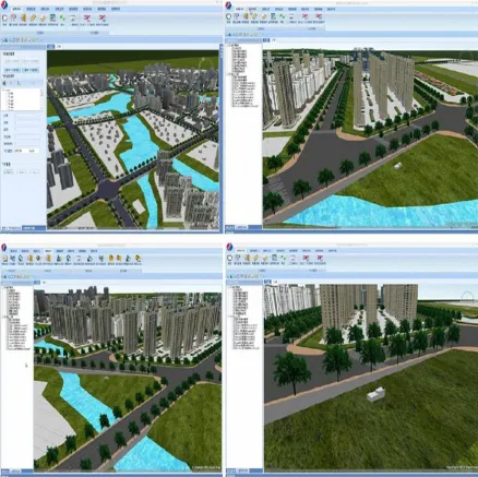
Some studies have been done in the field of three-dimensional (3D) modelling of proposed highway projects to facilitate planning, design and construction phases. In [14], a model was developed for the highway to display properties of alternative solutions. The findings of study [15] also demonstrated that 3D modelling with corresponding analysis can improve significantly the performance of highway improvement. According to the results of study [16], the 3D visualization of the proposed project can increase users' understanding and help them obtain detailed information about the project and its context. Based on the conclusion of study [17], a 3D model can provide a complete image of the proposed project prior to completion. In addition, 3D modelling technology was used to emphasize aesthetic concepts during highway design in the study [18].
3. The proposed approach
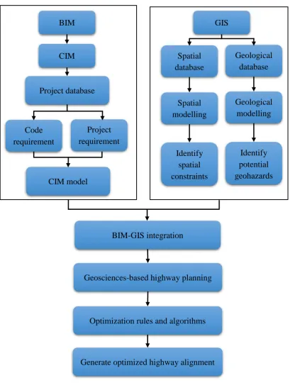
There are many factors that influence the alignment selection. The main geological features should be considered emphatically. Moreover, the alignment selection is impacted by the space constraints and disturbance of the existing projects. The proposed model that integrates the BIM and GIS systems carries out spatial data analysis to facilitate the highway alignment at the planning stage. It can minimize the time and efforts needed to assess different highway alignment alternatives and automatically generate several alignment options and the cut-fill quantities and costs related to each alternative. The proposed approach is summarized in Figure 1.
Figure 1. The proposed approach overview
3.1. Ontology and semantic modelling
Without the application of BIM, highway planning used to experience significant difficulty. Cut and fill calculations are time-consuming and tend to be very costly. Accurate earthwork calculations can help reduce overall costs for the highway project. By utilizing BIM, the cut and fill calculations can be conducted automatically.
Recently, GIS has emerged as a powerful computer-based tool that includes data management, spatial analysis and geographical visualization. For geotechnical purposes, GIS has been developed and applied to predict and plan for natural hazards, such as earthquakes and landslides. Topographic and geologic data and information were obtained from the geological database. The gathering data were manipulated in GIS to obtain geological analysis reports and various highway subsections.
BIM
CIM
Code
requirement
s
Project
requirement
s
Project database
CIM model
GIS
Spatial
database
Geological
database
Spatial
modelling
Geological
modelling
Identify
spatial
constraints
Identify
potential
geohazards
BIM-GIS integration
Geosciences-based highway planning
Optimization rules and algorithms
BIM and GIS systems have a different level of information and data structures. Seamlessly integrating these two systems is not easy. The ontology technology as part of semantic web technology is introduced to facilitate the integration. Ontology is defined as explicit specifications of a conceptualization that can be used to describe information such as concepts, relationships, data properties and restrictions within a domain in a machine-readable manner, and it is usually instantiated for a target system [19].
The aim of semantic web technology is to enable data to be shared easily by wider communities and to be processed automatically. Semantic web technology can integrate data from different sources because it can provide machine-readable schemas-ontologies [20]. Moreover, semantic web technologies also allow bidirectional transformation between BIM and GIS. Ontology defines the terms and transforms them into semantic annotations. In practice, ontologies typically support applications by contextualizing data, capturing meaning, facilitating rule application, standardizing terminology and producing new knowledge. The semantic information is specifically defined in both domains, but data integration is still possible on a semantic level. In addition, the defined ontologies still available for future use. The data exchanges are realized by the adoption of semantic web technologies. The interface of the integrated BIM and GIS model is shown in Figure 2.
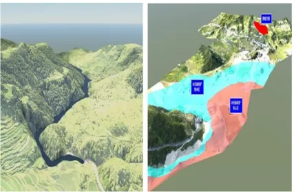
3.2. Geological analysis
The proposed model incorporates the geotechnical planning into the infrastructural design and thus increases the collaboration and avoids misunderstanding between the two parties. During the analysis process, the potential geohazards can be identified and mitigated or avoid; the geological information of the site is presented vividly. This would help the engineers in further analysis and design of the proposed highway project and related structural works. The geotechnical analysis may lead to several required changes in the highway design. These changes then are transferred back to the BIM model. This analysis provides efficient and effective screening to concerned area studies and enables a reasonable view of overall area risks. The section of geological analysis is displayed in Figure 3.
Figure 3. The example of geological analysis
3.2.1. Landslide
Prior to construction, a detailed geotechnical analysis of the site is required to identify the landslide risks because they are one of the most common and serious geological hazards. GIS can be used to predict landslide risk by incorporating information about landscape, geologic origin and weather conditions. Further analysis that takes into account the information, such as maximum rainfall, average annual rainfall and historic landslide, can predict the potential degree of landslide for the area.
3.2.2. Seismic hazards
A significant effort is needed to develop refined seismic design procedures for highways due to the damage resulting from recent large earthquakes [21]. The possibility of soil liquefaction after quakes should also be considered. In addition, the bearing capacity of the underlying soil may be exceeded after an earthquake, which leads to embankments sliding and crack openings on the highway surface.
magnitudes were chosen for further seismic analysis. After the seismic analysis, the liquefaction results of the selected points were achieved. This can give users a more comprehensive knowledge of the site situations and help them develop a solution to avoid or alleviate any seismic hazards.
3.3. Cut and fill calculations
Cut and fill cost accounts for almost 25% of the total project cost [22]. Owing to the complexity in cut and fill calculations, it is essential to adopt GIS technology in the calculation with the limitation in the BIM model [23]. The proposed model that integrates BIM and GIS is used to carry out cut and fill calculations.
The highway geometry information in BIM includes road shape, cross-section, centrelines, elevation, curb and embankment. While the information such as triangle co-ordinates and group, geographical and geological reference, soil type and terrain data can be accessed in the GIS model. The data in BIM and GIS are stored in IFC and GML format, respectively. Semantic web technology allows the integration to combine in the same platform. The quantity calculations of cut and fills are based on the existing topography elevation in the GIS model. The earthwork simulation aims to minimize the earthwork by balancing the cut and fill operation.
In the highway project, vertical alignment is based on the centreline of the road, so the centreline is regarded as the reference line. The centreline elevation occasionally represents the topography of the entire cross-section in terms of earthwork balancing. The term optimal centreline elevation is a centreline elevation where cut and fill are balanced within the cross-section. The main idea of this method is to make the earthwork optimization possible in terms of cut-fill balancing and earthwork minimization. A mathematical representation of the method is shown in Equation (1).
∑𝑛𝑖=1𝑉𝐶(𝑖) = ∑𝑚𝑗=1𝑉𝐹(𝑗), (1)
Where 𝑉𝐶(𝑖) is the volume for cut areas in cross-section; 𝑉𝐹(𝑗) is the volume for fill areas in
section; n is the number of cut areas in section; and m is the number of fill areas in cross-section.
3.4 Optimization algorithms
In the highway alignment planning phase, the general practice is to identify several alignment options and decide the optimal option based on the multiple rules. Economic considerations are one of most essential factors influencing highway projects [24]. In some cases, mitigating risks against individual hazard may increase vulnerability to another hazard. An economic highway alignment may more vulnerable to geohazards. The highway design should aim at optimizing overall risks and costs and carry out this efficiently and effectively.
Genetic algorithms (GAs) were previously used for highway alignment optimization [25]. GAs are suitable for optimization problems with several local optima and fits to parallel processing. In these specified GAs, the problem (highway alignment optimization) is considered the environment, and a set of possible solutions to the proposed problem is regarded as the population. Each alignment in the population is referred to as a chromosome and encoded into a string representation. At every generation, the alignment alternatives (individuals) compete with each other for reproducing offspring based on their fitness (minimum cost) to the environment (the problem) by using genetic operators (like mutation or crossover). Through several successive generations, the most fit alignments would survive and impact future generations, whereas poorly adapted alternatives would become extinct. The alignments (population) finally converge to a near-optimal solution.
function) rather than auxiliary or derivatives knowledge; and (4) use probabilistic rules rather than deterministic rules [26]. Despite the above benefits, it should be noticed that GAs are not always suitable to all problems, but they can be regarded as an effective approach for finding near-optimal solutions fast. The objective function used in this study can be written in Equation (2).
min
𝑓1,𝑓2,…,𝑓𝑛
𝐶 = 𝐶𝑃+ 𝐶𝐸+ 𝐶𝑅+ 𝐶𝑈, (2)
Where 𝑪 is total cost; 𝑪𝑷 is pavement cost; 𝑪𝑬 is earthwork cost; 𝑪𝑹 is right-of-way cost; 𝑪𝑼
is user cost; and 𝒇𝟏, 𝒇𝟐, … , 𝒇𝒏 are decision variable factors.
4. Case Study
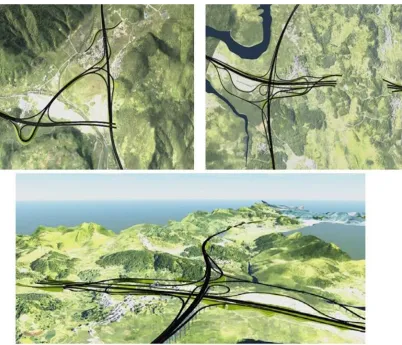
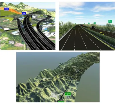
The DuAn highway construction project that is an important part of highway networks in Guizhou Province locates in the southwest part of China. It includes earthwork, pavement, slope protection and water drainage. The total length of the project is 282.9 km and the total project cost is 44.63 billion Yuan. The project is complicate due to several reasons: 1) the natural conditions is harsh; 2) the route layout is heavily impacted by existing structures such as railways, bridges and pipelines; 3) the selection of design planning is difficult. Moreover, the project area is a seismically active region, where a large-intensity earthquake has the potential to cause damage to the highway. Seismic shaking can also lead to soil liquefaction and damage to the highway surface. A seismic hazard analysis was undertaken for the project site to decide the seismic loads. According to loads and code requirements, the design of the highway could be generated. The 3D visualization model of the highway is presented in Figure 4.
Construction activities consisted of excavation, subbase, base, subgrade, embankment, surface,
drainage and slope protection. The major tasks in the work package were earthwork excavation and backfill, highway subbase and surface, slope protection and water drainage. For this project, three
alignment options were available to determine the optimal alignment alternative. All three alignments used the same structural components and had the same start and end-point. Each of the
three alignments had separate geological analysis, cut and fill calculations, and cost analysis. The cost and schedule durations could be estimated from a case-based reasoning method. Based on all the above analysis, the optimal alignment was selected. The optimized highway alignment is displayed
in Figure 5.
Figure 5. Optimized alignment for DuAn highway
5. Results Discussion
Considering all the important factors, alignment 2 therefore is the optimal option. The comparison results of the three alternatives are summarized in Table 1.
Table 1. Comparison of the three highway alignments
Alternatives Cut & Fill quantities
Surrounding conflicts
Geological conditions
Construction cost
Highway 1 Low High Low High
Highway 2 Medium Low Medium Medium
Highway 3 High Low High Low
The results indicate that the highway alignment determined by the proposed model can avoid the disastrous soil structure and geohazards, conform to the terrain changes and mitigate the disturbance of the existing projects. The earthwork calculation assisted by the proposed model also generates accurate results that save costs and time at the construction stage. In addition, the proposed model provides sufficient important information to facilitate the decision-making process.
6. Conclusion
Highway alignment planning is usually a complex and time-consuming process. The evaluation of different alignment alternatives is even more time-consuming and tends to be costly. The proposed model integrates BIM and GIS systems to facilitate the process. The integration of BIM and GIS systems is complex, however, and includes a large amount of data. Semantic web technologies and ontology were used to encourage the possibility of integration.
The proposed model improves the efficiency of the geotechnical and infrastructural planning and design process. It closes the gap in the information flow between the highway design and the geotechnical analysis, and it provides a 3D highway model. Moreover, the adoption of semantic web technologies allows for data exchanges between BIM and GIS systems and thus increases data interoperability. Furthermore, the optimization algorithms (GAs) also are used to select the optimal alignment. The proposed model is able to maximize control of geohazards and minimize project costs concurrently.
The automation process of the proposed model provides an opportunity to identify an optimal alignment in a timely way. The adoption of the proposed model on a real highway project has proved the potential of the application in the industry. As both BIM and GIS systems continue to develop in the civil infrastructure sector, the proposed model could become more shared and acceptable in the industry.
Author Contributions: Conceptualization, L.Z. and Z.L.; methodology, J.M.; software, Z.L.; validation, L.Z., Z.L.; resources, L.Z.; writing—original draft preparation, L.Z.; writing—review and editing, J.M.; visualization, Z.L.
Funding: This research was funded by National Key Research and Development Program of China, grant number 2018YFF0300306, Beijing University of Technology, grant number 2018JG08704, and The APC was funded by the both grants.
Acknowledgments: The authors would like to thank the Beijing University of Technology for its support through the research project. The authors would like to thank China Communications Construction, China Railway Group Limited, China State Construction Engineering Corporation, and China Association of Technology Entrepreneurs for providing data to conduct this research. In addition, I would like to thank all practitioners who contribute in this project.
Conflicts of Interest: The authors declare no conflict of interest.
References
1. AASHTO A policy on geometric design of highways and streets; American Association of State Highway and
Transportation Official: Washington D.C., 2004.
2. Cheng, J.-F.; Lee, Y., Model for three-dimensional highway alignment. J. Transp. Eng. 2006,132 (12), 913-920. doi: 10.1061/(asce)0733-947x(2006)132:12(913)
3. Penttilä, H. Describing the changes in architectural information technology to understand design complexity and
free-form architectural expression; 2006; pp 395-408.
4. Sadeghi-Niaraki, A.; Varshosaz, M.; Kim, K.; Jung, J. J., Real world representation of a road network for
route planning in GIS. Expert Systems with Applications 2011,38, 11999–12008. doi: 10.1016/j.eswa.2010.12.123. 5. Isikdag, U., Underwood, J., and Aouad, G., An investigation into the applicability of building information
models in geospatial environment in support of site selection and fire response management process. Adv. Eng.
Inf 2008,22 (4), 504-519. doi: 10.1016/j.aei.2008.06.001.
6. Kim, H.; Chen, Z.; Cho, C.-S.; Moon, H.; Ju, K.; Choi, W., Integration of BIM and GIS: Highway cut
and fill earthwork balancing. Computing in Civil Engineering 2015, 468-474. doi: 10.1061/9780784479247.058. 7. Karan, E.; Irizarry, J., Developing a spatial data framework for facility management supply chains. In
Construction Research Congress, 2014; pp 2355-2364.
8. bSDD, BuildingSMART Data Dictionary. 2014.
9. De Laat, R.; van Berlo, L., Integration of BIM and GIS: The development of the citygml GeoBIM extension.
In Advances in 3D Geo-Information Sciences, Kolbe, T. H.; König, G.; Nagel, C., Eds. 2011.
10. El-Mekawy, M.; Östman, A.; Hijazi, I., An evaluation of IFC-CityGML unidirectional conversion. Int. J.
Adv. Comput. Sci. Appl 2012,3, 159-171. doi: 10.14569/ijacsa.2012.030525.
11. Karan, E. P.; Irizarry, J., Extending BIM interoperability to preconstruction operations using geospatial
analyses and semantic web services. Autom. Constr 2015,53, 1-12. doi: 10.1016/j.autcon.2015.02.012.
12. Deng, Y.; Cheng, J. C.; Anumba, C., Mapping between BIM and 3D GIS in different levels of detail using
schema mediation and instance comparison. Autom. Constr 2016,67, 1-21. doi: 10.1016/j.autcon.2016.03.006. 13. Costa, G.; Sicilia, Á.; Lilis, G.; Rovas, D.; Izkara, J. In A comprehensive ontologies-based framework to
support retrofitting design of energy-efficient districts, European Conference on Product and Process Modelling
(ECPPM), Limassol, Cyprus, 7-9; Limassol, Cyprus, 2016.
14. Jha, M. K.; McCall, C.; Schonfeld, P., Using GIS, genetic algorithms, and visualization in highway
15. Bailey, K.; Brumm, J.; Grossardt, T. Integrating visualization into structured public involvement: Case study of
highway improvement in central Kentucky; Transportation Research Board: Washington, D.C, 2002; pp 50-57.
16. Keister, M. S.; Moreno, D. Cutting-edge visualization tools: Graphic simulations that stimulate project
understanding and decision making; 2002; pp 9-15.
17. McDaniel, R. E. See it before it’s built; 2002; pp 28-31.
18. Janikula, T., and Garrick, N. W. Three-dimensional visualization approach to illustrating esthetic concepts for
highway design; Transportation Research Board: Washington, D.C, 2002; pp 35-40.
19. Gruber, T. R., A translation approach to portable ontology specifications. Knowl. Acquis 1993,5 (2), 199-220. doi: 10.1006/knac.1993.1008.
20. Horrocks, I., Ontologies and the semantic web. Commun. ACM 2008, 51, 58-67. doi: 10.29085/9781783301522.002.
21. Yen, W. P.; Fallon, J. D. O.; Cooper, J. D.; Higgins, M., FHWA/MCEER Seismic Research for
Transportation Structures. Structures 2001, 1-9. doi: 10.1061/40558(2001)194.
22. Hare, W. L.; Koch, V. R.; Lucet, Y., Models and algorithms to improve earthwork operations in road
design using mixed integer linear programming. Eur. J. Oper. Res. 2011, 215 (2), 470-480. doi: 10.1016/j.ejor.2011.06.011.
23. Nassar, K.; Aly, E. A.; Osman, H., Developing an efficient algorithm for balancing mass-haul diagrams.
Autom. Constr. 2011,20 (8), 1185–1192. doi: 10.1016/j.autcon.2011.05.002.
24. Goktepe, A. B.; Lav, A. H., Method for optimizing earthwork considering soil properties in the geometric
design of highways. J. Surv. Eng. 2004,130 (4), 183-190. doi: 10.1061/(asce)0733-9453(2004)130:4(183).
25. Jha, M. K.; Schonfeld, P., A highway alignment optimization model using geographic information systems.
Transp. Res., Part A:Policy Pract. 2004,38 (6), 455-481. doi: 10.1016/j.tra.2004.04.001.
26. Goldberg, D. E., Genetic algorithms in search, optimization, and machine learning. Addison-Wesley Reading,