© 2017 IJSRST | Volume 3 | Issue 7 | Print ISSN: 2395-6011 | Online ISSN: 2395-602X Themed Section: Science and Technology
Optimal Path Calculation for Route Leveraging APIs Using
Location Based Service
Zahoora Abid
1, Tahera Abid
2,Khutaija Abid
31,2Assistant Professor, Nawab Shah Alam Khan College of Engineering and Technology, Hyderabad, Telangana, India 3Assistant Professor, Al-Habeeb College of Engineering and Technology, Hyderabad, Telangana, India
ABSTRACT
A location based service (LBS) is an application for user’s mobile device that requires necessary information about where the mobile device is located. Location-based services shall be query-based and provide the end user with valuable information, for e.g LBS enable mobile users to query points-of-interest (e.g.,ATM, restaurants) on various features (e.g., category, price, quality, and variety). They manage points-of-interest (POIs) specific to their applications, and enable mobile users to query for POIs that match with their preferences and time constraints and also it secures a user identity and locality within basic mobile communication services. For this approach this paper provides the survey about various techniques for providing the accurate and efficient query for the mobile users. Keywords:Location Based Services (LSB), POIs, Query Processing
I.
INTRODUCTION
There is growing need for useful approaches involving use of global positioning systems (GPS) information fromGPS trackers for traffic analysis. In recent years, activity-based evaluation using GPS equipment’s as informationcollectors has been a principal challenge. All these forms of research focus on data from wearable GPS recorders considering of effortless specified undertaking logging and interactive validation with users. As data have improved,more sophisticated approaches of data assortment have been developed, represented at first by the shift from travel toactivity diaries, and continuing on to the progress of GPS enabled activity surveying. Traffic evaluation is a componentof key points in developing international locations that require better and efficient monitoring.
In order to compensate for uncertainties in journey time due to accidents, bad weather, traffic congestion, and so on, vehicles hauling time-sensitive freight build “buffer time” into their routes in order to help ensure that deliveries willprobably be made on time. Building buffer time into routes tends to increase the likelihood of on-time delivery, animportant measure of service. However, buffer time also tends to reduce measures of productivity
associated with cost, such as driver and equipment idle time and the number of miles travelled per hour. An LBS requires 5 basiccomponents: the service provider’s software applications, a mobile network to transmit information and requests forservice, a content provider to supply the end user with geo-specific information, a positioning component (see GPS) andthe end user's cellular device. There is an escalating demand to accurately and quickly determine the locationof a mobile at low cost. Location-based applications areflattering popular and available and provide the user withinformation based on their location. Computing the shortest path is foremost challenge within the spatial databases. The path computed by making use of the pre-stored information is not accurate. Thus, there is necessity for the live traffic data. There are a number of online service traffic providers like NAVTEQ [4],Tom tom[5],Google maps[6].However these traffic vendors do not furnish.
extensivelystudied and many efficient speedup techniques have beendeveloped to compute the fastest path in a matter ofmilliseconds. At the present time, a few online services provide live traffic information (by using examining accrued informationfrom road sensors, traffic cameras, and crowd sourcing approaches), These systems can calculate the image shortest pathqueries based on present traffic information; nevertheless, they don't record routes to drivers constantly because of high operating costs. Answering the shortest paths on the live traffic data can be considered as a continuous monitoringdifficulty in spatial databases, which is termed as online shortest paths computation in this work. Short-time periodtraffic forecasting objectives to furnish more reliable travel information service, to be able to support people in makingmore reasonable traffic decisions. With the growing availability of traffic data along with the progress of conversationscience, both the capacity and accuracy of travel time forecasting were enormously enhanced in real-time conditions anda great quantity of forecasting methods have been applied throughout recent years. Nonetheless, they're insufficient whenconfronted with the act world traffic issues, considering the real-time traffic condition can be affected conveniently andchanged continuously.
In most cases, the shortest path is computed by using offline information pre-stored within the navigation techniquesand the weight (travel time) of the road map is estimated by way of the avenue distance or old data. Unluckily, roadtraffic circumstances change over time. Without live traffic instances, the route returned through the navigation system isnow not guaranteed a correct result. Those historical navigation techniques would endorse a route based on the prestoreddistance information. Note that this route passes through four street upkeep operations (Indicated by way ofpreservation icons) and one traffic congested street (indicated by means of a redline). These days, several on-lineofferings furnish reside visitors knowledge (through analysing collected information from road sensors, traffic cameras,and crowd sourcing strategies),These systems can calculate the photograph shortest path queries based on currentreside
visitors information; nonetheless, they don't record routes to users regularly due to high working charges. Answering theshortest paths on the live traffic data may
also be considered as a steady monitoring problem in spatial databases.
II.
EXISTING SYSTEM
The shortest direction influence is computedbased on the live traffic circumstances [1]. They carefully analysed the prevailing work and speak about their inapplicability to the problem. To deal with the difficulty, they suggested a promising architecture that proclaims the index on the air. They first determined a predominant characteristic of the hierarchical index structure which permits us to compute shortest path on a small component of index. This major feature is utilized in their resolution, Live Traffic Index (LTI). Their experiments verified that LTI is a Pareto optimal answer in terms of four performance factors for online shortest path computation.
Shortest path computation is an principal function in present day auto navigation methods[2]. This function helps adriver to figure out the excellent route from his current place to destination place. In most cases, the shortest path iscomputed by using offline information pre-stored within the navigation techniques and the weight (travel time) of theroad map is estimated by way of the avenue distance or old data. The online shortest route computation; the shortestroute result is computed based on the traffic situations. Analyse the prevailing work and speak about their inapplicabilityto the situation (because of their prohibitive protection time and massive
transmission overhead). To address the
concern,advocate a promising structure that publicizes the index on the air. First determine a foremost characteristic of thehierarchical index constitution which enables us to compute shortest path on a small section of index.
III.
PROPOSED SYSTEM:
process. The proposed procedure entails almost always threepredominant modules, user module, LBS module and Route-Saver module. In user module user receives a location mapincludes locations, user location and route map from user place (source) and possible destination. In our proposed work, the users require accurate results that are computed with appreciate to live traffic information. The entire works require the LBS to know the weights (travel times) of all road segments. Considering that the LBS lackthe infrastructure for monitoring road traffic, the above works are inapplicable to our problem. Some works try andmodel the travel occasions of street segments as time-various features, which may also be extracted from historicaltraffic patterns. These services may just capture the consequences of periodic events(e.g. rush hours, weekdays).Nevertheless; they nonetheless cannot reflect traffic information, which can be effected by sudden events, e.g. Congestions, accidents and road maintenance. The LBS module is responsible for accumulating the specified data from consumer and LBS generate optimizedinformation which includes consumer’s present area and route log to the destinations. Then this information istransferred to the Route-saver. Route-saver utilizes the contemporary traffic understanding bought from traffic providerand calculates the journey time and most beneficial path to source and destinations by using Nearest Neighbor queries.
Figure 2. Maintenance of Structures at LBS
Conservative travel time bounds. Given an edge e(v, v-), we define cw-(e) and cw+(e) as conservative lower boundand upper-bound of travel time one, observe that the lower bound cw-(e) is limited by the Euclidian distance of eand maximum driving speed Vmax,
cw- (e) = dist(e)/ Vmax
To reduce the number of route requests while providing efficient results, we combine information throughout a couple of routes within the log to derive tight lessen/higher bounding journey times. We also propose effective strategies.
to compute such bounds efficiently. Additionally, we compare the influence of exclusive orderings for issuing routerequests on saving route requests. And we learn the best way to parallelize route requests in order to reduce the queryresponse time additional.
Above figures show the screen shots our proposed work, the user has an access to router via an internet. Based on hispresent location he has to choose the destination point, and then LBS will communicate with server and shows you thenearest places of his choice.
Figure (a)and(b) shown window where you can choose the destination you need to go, onceyou selected point server will give you the nearest requested destination with shortest path. We can see the nearest destination point in the figure 3, here user wants to visit to a hospital, and using an applicationhe will enter the hospital as destination point. For the requested information server will revert back with all hospitalswhich is located around the user’s current location. As we see in the figure 3, all the hospitals are marked in red colorand the nearest hospital is marked in a purple color, here user location is marked as source and is in green color.
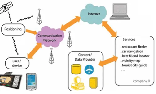
Figure 4:Location based services network architecture
(a)
(b) Destination point request
Nearest Destination Point
Query processing
Algorithm 1: Location Point based Tree (LPT with Inverted Index):
The location point tree saves the location points along with the service details. The service identifies the service by using the spatial POI which will be stored on the LPT_II. To speed up itinerary process in this indexes all the objects’ subspace spatial scopes by an LPT tree where the subspace spatial scopes are stored in the leaf nodes as data entries. Additionally, to support service recommendation, this follows mapping module and KNN search [7]. In the diagram p1, p2, p3, p4, p5…p7 are the service points. In the proposed system every service point will be stored with an mapping key for fast service search. The proposed system stores the above service point in the tree style.
Algorithm 2: LPT_II maintenance tree Steps
The following table represents the location point and available service details in the location. The service can able provide appropriate services for the user interest based on the location point based service list. This helps in two ways. One is the retrieval time has reduced. And the next is fast search in the LPT helps to avoid the unavailable services [8].
1. Initial location source with respect point p1,p2..pn 2. For every point in the source P do
a. Initialize service S1…Sn for respective points. b. Set service and code for every service
3. Get rank for each service and store into the ascending order.
4. Store the node in the top level based on the rank 5. Prune the other items from the LPT.
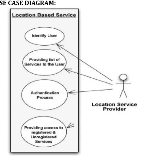
USE CASE DIAGRAM:
Figure 5 : Use case diagram for LBS
IV.
CONCLUSION
In this paper, we propose a solution for the LBS to process range/KNN queries such that the query results haveaccurate travel times and the LBS incurs few number of route requests. Our solution Route-Saver collects recent routesobtained from an online route API (within d minutes). During query processing, it exploits those routes to deriveeffective lower-upper bounds for saving route requests, and examines the candidates for queries in an effective order.We have also studied the parallelization of route requests to further reduce query response time.
REFERENCES
[1] M. Argon and K. Sirisha, “Live Activity List Based Shortest Path Calculation”, Issue 09, 2015. [2] R.Subashini and A.Jeya Christy, “Online Shortest Path based on Live Traffic Circumstances” Volume 3, Issue. 11, 2014.
[3] DekondaSindhuja, R Vasavi and A
KousarNikhath, “Online Shortest Path Computation using Live Traffic Index”,Volume 25, Issue 3, 2015.
[4] “NAVTEQ Maps and Traffic,”
http://www.navteq.com, 2014.
[5] “TomTom NV,” http://www.tomtom.com, 2015. [6] ”Google Maps,” http://maps.google.com, 2015. [7] D. Zhang , CY. Chow, Q. Li, X. Zhang, Y. Xu,
―Efficient Evaluation of k-NN Queries Using Spatial Mashups‖, Advances in Spatial and Temporal Databases (Lecture Notes in Computer Science), Vol. 6849, pp.348-366, 2011.