Dynamic Multi-Objective Navigation in Urban
Transportation Network using Ant Colony Optimization
Sina Abolhoseini 1, Abolghasem Sadeghi-Niaraki 2
Received: 11. 12. 2016 Accepted: 00. 07. 2017
Abstract
Intelligent Transportation System (ITS) is one of the most important urban systems that its functionality affects other urban systems directly and indirectly. In developing societies, increasing the transportation system efficiency is an important concern, because variety of problems such as heavy traffic condition, rise of the accident rate and the reduced performance happen with the rise of population. Route finding and navigation are two effective tools to reduce the pressure on the transportation system. Better navigation methods can reduce the traffic concentration in specific areas. In most of the cases, transportation networks are changing through time and they don’t have a static status. On the other hand, different users consider different objectives when they want to move through the transportation network. So, this paper proposed a novel method to solve dynamic navigation and route finding problem while considering different objectives. This new method is based on multi-objective Ant Colony Optimization (ACO). Experiments are designed in a simulated network and results are compared with static navigation in single-objective and multi-objective mode. Results indicated that the proposed method is performing very accurate in finding the optimal paths. Also the proposed method for dynamic navigation is performing better than the static navigation. It has improved the trip duration of the 80% of the altered routes and decreased the trip duration of some experiments up to 50%. These results indicate that the proposed method has the ability of solving multi-objective dynamic navigation in urban transportation systems in the presence of high rate traffic information.
Keywords: Intelligent Transportation System, dynamic route finding, navigation, ant colony optimization, multi-objective problem.
Corresponding author E-mail: [email protected]
1. Master Degree, GIS Department, Faculty of Geodesy and Geomatics Engineering, K. N. Toosi University of Technology, Tehran, Iran
2. Assistant Professor, GIS Department, Faculty of Geodesy and Geomatics Engineering, GIS Excellence Center, K. N. Toosi University of Technology, Tehran, Iran
1.
Introduction
Route finding problem and navigation are important issues in transportation systems and researchers are still trying to find better solutions in solving them under different circumstances. Different categories are presented for these problem. In one of these categories, route finding has been divided in to two main classes, single-objective and multi-objective [Chakhar and Martel, 2003]. Generally, decision making in real world depends on different objectives. For example, in real world route finding problems, the shortest path or the quickest path are not always sufficient [Pahlavani et al. 2006]. Multi-objective route finding is a Non-deterministic Polynomial-time hard (NP-hard) problems [Mooney and Winstanley, 2006]. Reaching the exact solution in a reasonable period of time is not possible and an approximation of the solution have to be accepted. Besides, in route finding problems, computation complexity rises with the size of network and more time should be spent. This dependency is the reason of many researches in this area [Pahlavani, et al., 2012]. Ant Colony Optimization (ACO) is one of the meta heuristic algorithms that can be used to solve multi-objective route finding
[Masoomi et al. 2011]. This algorithm was firstly proposed in 1992, by Marco Dorigo to solve optimization problems [Dorigo, 1992]. In ACO the process of searching for food source by ants is simulated to find the best solution in the solution space [Masoomi et al. 2011].
Route finding problem can be categorized into three classes due to the available information (Figure 1), Non-Adaptive routing rule (NAR), Open-loop Adaptive Routing rule (OAR) and Closed-loop Adaptive Routing rule (CAR). Algorithm works with prior information of the network in NAR. This information can be static values of travel time or the historical information during a specified period of time. Classic algorithms like Dijkstra [Dijkstra, 1959] can be used for this class. In OAR class, only real time information is available and in CAR both are available. In OAR and CAR, the initial suggested path should be changed while updating the traffic information [Fu, 2001]. Users are faced with a transportation network in which the values are changing through time due to real world situation. For example, travel time in a particular street changes due to the traffic condition in that particular street [Zakaria and et al. 2015].
Sina Abolhoseini, Abolghasem Sadeghi-Niaraki
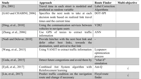
Many algorithms have been proposed for route finding and navigation. These algorithms can be categorized into three classes from another point of view, certain, heuristic and meta heuristic algorithms. Certain algorithms find the exact solution by processing all the network without using additional information to guide the search direction or to omit some of the areas (e.g. Dijkstra). Heuristic algorithms use additional information, like Euclidean distance, to decrease the computation complexity and therefor the computation time (e.g. A*) [Abolhoseini and Sadeghi-Niaraki, 2016]. Meta heuristic algorithms are inspired from natural events in order to solve the problems. For example, Genetic Algorithm is based on the mechanics of natural selection and genetics to search through decision space for optimal solution [Boroujerdian, et al. 2015]. The process of evolution is simulated through chromosomes, gens, crossover and mutation. Some researchers investigated real time algorithms. For example, in 2001 a solution to navigate vehicles in a transportation network is proposed in which the travel time in each street is modeled and predicted as random variable [Fu, 2001]. So, user can be informed about the travel time of a street before entering it and as a result better navigation through the network is possible. This paper used travel time as the only objective for analysis. In 2006, an optimal routing technique is proposed for stochastic time-dependent networks [GAO and CHABINI, 2006]. In stochastic time-dependent networks, travel time can be modeled as a random variable with a time-dependent distribution. In this method user was navigated from the origin to the destination. User’s path may change through
Table 1. Literature review summary
Study Approach Route Finder Multi-objective
[Fu, 2001] Travel time in each street is modeled and
predicted as random variable Label Correction Algorithms [GAO and CHABINI, 2006] Specifies the next node to take at each
decision node based on realized link travel times and the current time
DOT-SPI
[Ding, et al., 2010] Using the communication services between vehicles to navigate users
V2R2
[Zhang, et al., 2006] Use GPS of taxies to extract traffic
information ANN
[Nadi and Delavar, 2010] Provide him/her with the next best link and defer other best links, towards the destination, until arrival to that link
-
[Wang, et al., 2015] Using VANET to extract traffic information Lyapunov optimization process [Ueda, et al., 2015] Detect future congestions and avoid them by “what if”
simulation [Eydi, et al., 2017] Combined Ant System algorithm with
Reinforcement learning Ant-Q √
[Lin, et al., 2017] Predict traffic condition on the navigation route and change if necessary
Floyd route
finder √
traffic conditions were predicted with a statistical spatial-temporal method and optimal route was computed based on “what happens if?” [Ueda, et al., 2015]. Eydi and et al. proposed a new hybrid algorithm by combining Ant Colony and Reinforcement Learning. This algorithm is designed to solve dynamic navigation in urban transportation networks by considering four objectives to solve navigation problem [Eydi et al. 2017]. Eydi et al. combined four objectives to solve multi-objective dynamic route guidance. Lin and et al. also proposed a Dynamic En-route Decision real time Route Guidance (DEDR) schema to reduce traffic congestions. DEDR predicted traffic condition based on shared traffic information and used alternative optimal routes to change user’s direction in case of congestion. Travel time, fuel consumption and vehicle density are the objectives considered in this schema [Lin et al. 2017]. This paper also combined the
Sina Abolhoseini, Abolghasem Sadeghi-Niaraki
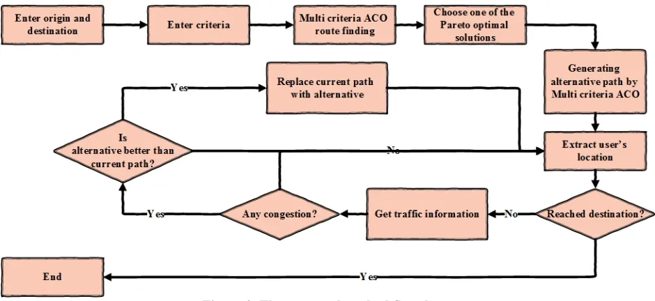
two main phases; in the first phase, origin and destination are entered by user, as well as the desired objectives. Then ACO is used to find the main best path. After that alternative paths are generated to be used in case of congestion or heavy traffic.Rate of decision making is increased by calculating the alternative paths in the pre-processing phase and using them in the navigation phase. Increasing the speed of decision making can give us the ability of using high rate information from infrastructure sensors e.g. Ubiquitous Sensor Networks. In the navigation phase user starts to move toward his/her destination. Location of the user is derived and algorithm monitors the path ahead. If any congestion happens, main path is replaced by the possible alternatives form the pre-processing phase in order to pass the user from better streets. To the best of our knowledge, a simultaneous solution for using pre-processing in dynamic navigation and considering dynamism and multi objectivity of navigation hasn’t been yet addressed in the transportation literature.
2.
Ant Algorithms
Ant algorithms are meta heuristic methods to solve complex problems which was first proposed by Marco Dorigo in 1992 [Dorigo, 1992]. These algorithms are actually simulating the behavior of ants in nature. Searching food by ants is usually simulated to find the best solutions in complex problems. In nature, each ant searches the environment individually to find a food source and they release a chemical while traversing. When another ant wants to start searching the space, choosing a path with higher chemical is more probable. Paths with higher amount of chemical are traversed by
more ants and therefore they are closer to the optimal solution.
Ants may rise this question that how they find food sources? The answer is a chemical substance called pheromone. Pheromone is a chemical that ants release while traversing. First generation ants search the space completely randomly and they release pheromone while traversing. This chemical footprint guides other ants to find the food source by smelling. Pheromone evaporates after a while to let other ants search for better paths and also other food source. This mechanism is the basis of ACO [Dorigo et al. 1999].
2.1 Ant Colony Optimization (ACO)
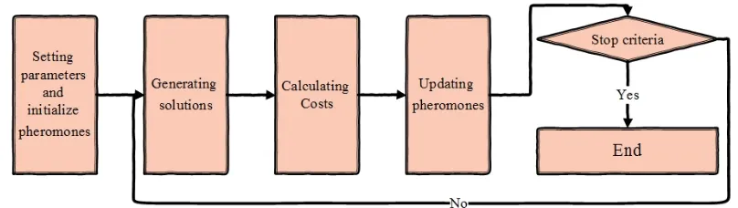
After modeling the problem in graph theory with a set of nodes and edges, the process of ACO is conducted as follow (Figure 2):
1. Setting parameters and initial pheromone values. In order to give each street an initial pheromone value, physical length, random values or a specific formula can be used. All the initial pheromones value is set to 1 in this research. α and β in Equation 1, determine the effect of pheromone and the cost in generating the ants, respectively [Jabbarpour, et al., 2014]. Number of ants can be determined by trial and error. Different runs of algorithm lead us to the correct number. Evaporation rate must be determined too.
2. Generating solutions. Each ant forms a solution for the problem. For example, in route finding each ant is a sequence of streets leading us from the origin to the destination. Probability of passing k-th ant from i node to j node is calculated by Equation 1. is the set of visited nodes by k-th ant. is the amount of pheromone on the specific edge between node i and j. determines the influence of pheromones on selecting the next node. is the desirability of choosing the specific edge between i and j. Typically it is equal to the reverse of the edge’s cost. controls the influence of .
∑∉ ∉ 0
(1)
3. Updating pheromones. Ants start form the origin and for passing from a node to another one, the probability is calculated from Equation 1. When ant gets to the destination, two tasks must be conducted. First of all, all the streets pheromones must be decreased. This is the mechanism of evaporation inspired from nature. Second task is increasing the pheromones of traversed path for each ant due to its fitness. These tasks together are applied through Equation 2.
1 ∆ (2)
∈ 0. 1 is a constant value called evaporation rate and m is the number of street traversed by the specific ant. Increasing value of pheromone amount on each link, traversed by k-th ant ( ), is calculated through Equation 3. In this Equation, Q is a constant value and is the fitness value of the traversed path by k-th ant [Dorigo, 1992].
∆ .
0
(3)
Sina Abolhoseini, Abolghasem Sadeghi-Niaraki
Figure 2. Ant Colony Optimization flowchart
4. Stopping Criteria. ACO stops whenever a stopping criteria is reached. Specific number of iterations, specific computation time or stable pheromones after a specific number of iterations are examples of stop criteria [Jabbarpour, et al., 2014]. Stopping criteria of the proposed technique in this paper is a specific number of iterations.
It should be noted that in this paper, cost of scenery is reversed in order to maximize it through optimization. When reversed function is minimized, it could be claimed that the original function is maximized.
2.2 Multi-Objective Ant Colony
Optimization
A Multi-Objective Problem (MOP) is defined as follow (Equation 4):
. . … . (4)
F(x) is the objective functions vector and it should be minimized. . . … is the decision variables. Usually there is not a particular solution to minimize all the objective functions, So, Pareto Optimal concept is used to investigate the multi-objective optimization problems. Pareto optimality is defined through follow definitions.
Definition 1. . . … . dominants
. . … . when .
1.2. … . .
and are two different decision vectors.
Definition 2. Decision vector ∗∈ Ω is a Pareto optimal if there is no decision vector
∈ Ω that ∗.
Ω represents the feasible decision space.
Definition 3. Pareto optimal set is defined as follows:
∗ ∈ Ω|∄ ∈ Ω: (5)
Definition 4. Pareto front is defined as follow:
∈ ∈ ∗ (6)
ζ represents the feasible objective space.
Multi colony ACO has been used in the proposed method of this paper.
In [Jozefoweiz et al. 2008], facing with multi-objective problems is categorized into three classes. Multi-objective optimization can be done without weighting, weighting before solving the problem and weighting after solving the problem. In the first class, an ideal solution is defined and algorithm selects solutions close to the ideal solution. In the second class, weights of each objective function is determined by specialists before the algorithm starts the computation. Objectives are combined together based on these weights. In these two classes, there is no room for user’s preferences [Coello Coello et al. 2002]. In the third and last class, after choosing the effective objectives for route finding by users, no initial weight is introduced and all the Pareto front solutions are given to the user to choose between them [Zitzler and Thiele, 1998]. The proposed method in this paper is based on the third class.
3.
The Proposed Technique
In this section, the proposed method based on ACO is discussed. Multi-objective ACO is used in this technique to find the optimal path between origin and destination. Origin and destination are entered by user as well as effective objectives for route finding among distance, travel time, scenery and difficulty. Multi-objective route finding is conducted using Multi Colony ACO and Pareto optimal front is given to the user to choose a route among them. 20 ants are generated for each colony and it takes 50 iterations to stop. α and β are 1 and 2, respectively (Equation 1), evaporation rate ( ) is 0.075 (Equation 2) and Q is 1 (Equation 3). These parameters are obtained through trial and error. Pre-processing starts after user chooses the route. In the pre-processing phase alternative paths are generated each time by assuming that one street is obstructed or congested. Congestion or obstruction is detected through travel time property of streets. Alternative paths are
Sina Abolhoseini, Abolghasem Sadeghi-Niaraki
Figure 4. Pseudo code of replacing the main route by its possible alternatives
generated using ACO with the selected objectives. Next phase is tracking and navigating the user through the network. In real world, user’s location can be extracted using vehicle or cellphone GPS sensor. In this phase, remaining edges ahead are observed after each update of the network traffic information. If any congestion happens, this method uses the alternative paths to alter user’s path and let the user get to the destination sooner. Flowchart of the proposed method can be seen in Figure 3. Pseudo code, is presented in Figure 4.
4.
Results and Discussion
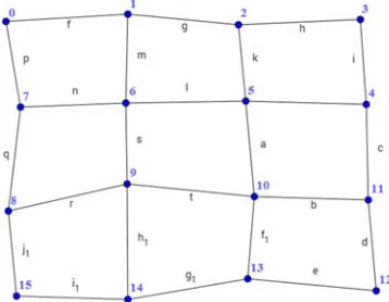
To check the accuracy of the proposed technique, Dijkstra algorithm is used as a certain algorithm to find the exact solutions in single-objective mode. A network of 16 nodes generated randomly and random variables for 4 different objectives are generated for each edge. Structure of the simulated network can be seen in Figure 5. Numerical results are reported after a short explanation about Dijkstra algorithm.
Figure 5. Structure of the simulated network
Dijkstra is a certain route finding algorithm used for static transportation networks [Dijkstra, 1959]. This algorithm is one of the label setting algorithms. Each node gets a label that indicates its shortest distance from the origin. Algorithm continues until all the nodes are checked [Magzhan and Mat Jani, 2013]. In order to test the proposed technique with Dijkstra algorithm, Dijkstra is implemented based on the pseudo code of Figure 6.
Start
Enter origin and destination; Choosing objectives;
Do multi‐objective ACO route finding;
Generate alternative paths by multi‐objective ACO; Start navigation;
While vehicle hasn’t reached destination { Extract car location;
Read traffic information from Available sensors; For streets ahead on the path {
If there is a congestion {
If there is an alternative path available {
If alternative travel time is better than the current { Replace the path;
} } }
} }
Figure 6. Implemented Dijkstra algorithm for dynamic navigation
4.1 Experimental Results
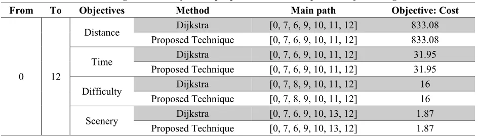
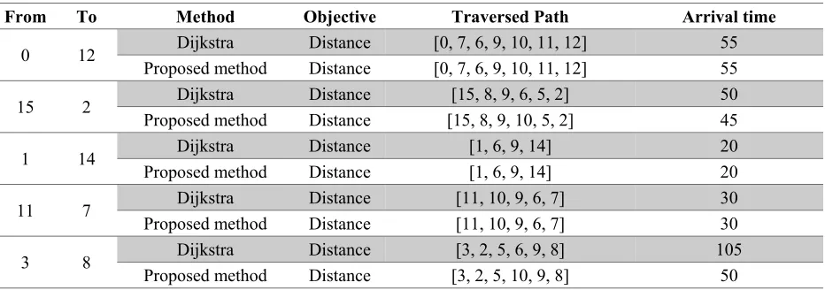
First of all, accuracy of the proposed method is compared to Dijkstra algorithm in finding the optimal main route with considering different objectives. In Table 2, two random nodes are selected from the network and the main route is calculated by the proposed method and Dijkstra algorithm. Dijkstra acts as a single-objective algorithm, so each objective is experimented separately. As it can be seen in Table 2, route finding from node 0 to 12 for different objectives are highly accurate. Calculated routes by the proposed method and Dijkstra algorithm are equal. Results are remaining unchanged after different times running the algorithm. We can increase number of tests, if we want to relay more on the stability of the algorithm. Effects of using a single-objective static navigation (by Dijkstra algorithm) and the
proposed method is tested in Table 3. Two cars are simulated to move between the selected random nodes in Table 3. One car uses static navigation (Dijkstra algorithm) and the other one uses the proposed method. In all the tests, distance is selected as the effective objective. Other objectives can be used instead. Traversed path is the path of the cars, after all the changes. Traffic information was updated for each 5 seconds, so the arrival time is reported based on the 5 seconds intervals. When a car arrival time is 55, it means that it arrived between 50 and 55 seconds after departing from the origin. As it can be seen in Table 3, arrival time of the car using the proposed method is better than the car using static navigation. When the cars were moving from 0 to 12, 1 to 14 and 11 to 7, there were no change in the main path. This may have different reasons. First reason can be the travel time of the initial path. If there was no congestion or heavy traffic condition, there was no need for change in the main path. Second reason can be the condition of the alternative paths. Based on the flowchart in Figure 3 or the pseudo code of Figure 4, if the possible alternative path condition wasn’t better, no change in the main path was applied.
Table 2. Assessing the accuracy of the proposed method compare to Dijkstra Algorithm Objective: Cost Main path
Method Objectives
To From
833.08 [0, 7, 6, 9, 10, 11, 12]
Dijkstra Distance
12 0
833.08 [0, 7, 6, 9, 10, 11, 12]
Proposed Technique
31.95 [0, 7, 6, 9, 10, 11, 12]
Dijkstra Time
31.95 [0, 7, 6, 9, 10, 11, 12]
Proposed Technique
16 [0, 7, 8, 9, 10, 11, 12]
Dijkstra Difficulty
16 [0, 7, 8, 9, 10, 11, 12]
Proposed Technique
1.87 [0, 7, 6, 9, 10, 13, 12]
Dijkstra Scenery
1.87 [0, 7, 6, 9, 10, 13, 12]
Proposed Technique
Start
Enter origin and destination; Choosing one objective; Do Dijkstra route finding; start navigation;
while vehicle hasn’t reached destination {
Extract car location;
Sina Abolhoseini, Abolghasem Sadeghi-Niaraki
Table 3. Comparing the arrival time of single-objective static navigation and the proposed method Arrival time Traversed Path Objective Method To From 55 [0, 7, 6, 9, 10, 11, 12]
Distance Dijkstra
12 0
55 [0, 7, 6, 9, 10, 11, 12]
Distance Proposed method
50 [15, 8, 9, 6, 5, 2]
Distance Dijkstra
2 15
45 [15, 8, 9, 10, 5, 2]
Distance Proposed method
20 [1, 6, 9, 14]
Distance Dijkstra
14 1
20 [1, 6, 9, 14]
Distance Proposed method
30 [11, 10, 9, 6, 7]
Distance Dijkstra
7 11
30 [11, 10, 9, 6, 7]
Distance Proposed method
105 [3, 2, 5, 6, 9, 8]
Distance Dijkstra
8 3
50 [3, 2, 5, 10, 9, 8]
Distance Proposed method
When cars were moving from 15 to 2, a congestion happened between 9 and 6, and main path was replaced with the alternative path by the proposed technique. This change caused lower travel time. The same happened when cars were moving from 3 to 8. In the main path, a significant congestion happened between 5 and 6. The proposed technique replaced that part of the path, when user was moving through, with the alternative path. In this particular experiment, travel time was reduced up to 50%.
In Table 4, the accuracy of the proposed method is assessed in multi-objective mode. In this table different multi-objective route findings are tested between node 0 and 12. These nodes are selected specifically to compare the results with Table 1. As it can be seen in Table 4, when route finding is initiated with distance and travel time as the effective objectives, Pareto optimal front contains only one solution. This solution minimizes both objective functions. A quick look into Table 2, show that both of the objectives are passing through [0, 7, 6, 9, 10, 11, 12]. It means that this solution is the global optimum and it dominants all other solutions. In all repetitions of the algorithm,
same solution is obtained. When difficulty is added to the effective objectives, two solutions are obtained from the Pareto optimal front. Closer look reveals that first solution is the minimization of difficulty objective and the second one is minimizing distanced and travel time. Costs and paths match Table 2 results. When we are considering all four objectives, 4 solutions are obtained. First solution represents the solution that minimizes the revers of scenery function. Second one is a solution with higher scenery value and lower difficulty value. Third solution minimizes difficulty objective and the last solution minimizes distance and travel time simultaneously. The second solution is a non-dominant solution and it comes between difficulty and scenery objectives. It means that it is a good solution if user wants to take a path with low difficulty and lots of scenery. Based on the experiments reported in Table 3, ACO acts accurately in multi-objective mode as well as single-objective mode.
Table 4. Evaluating the results of the proposed technique in multi-objective mode Cost Value Pareto Optimal Solutions
Objectives To
From
Scenery Difficulty
Travel time Distance
-
- 31.9560
833.08 route 1 : [0, 7, 6, 9, 10, 11, 12]
Distance Travel Time
12 0
-
16 32.8518
877.87 route 1: [0, 7, 8, 9, 10, 11, 12
Distance Travel Time
Difficulty route 2: [0, 7, 6, 9, 10, 11, 12] 833.08 31.9559 23 -
1.8726 29
32.08819 839.69
route 1: [0, 7, 6, 9, 10, 13, 12] Distance
Travel Time Difficulty
Scenery
2.6584 22
32.9839 884.48
route 2: [0, 7, 8, 9, 10, 13, 12]
3.4391 16
32.8518 877.87
route 3: [0, 7, 8, 9, 10, 11, 12]
2.6533 23
31.9559 833.08
route 4: [0, 7, 6, 9, 10, 11, 12]
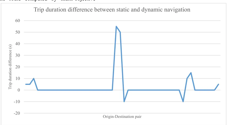
continues. The performance of the proposed method was assessed through testing 50 pairs from 240 possible pairs in the simulated network. Performance was tested by navigating with a static navigation using multi-objective ACO and comparing the results with navigation using the proposed method. One car simulated to move on the static route computed by multi-objective
ACO algorithm and another one simulated to use the proposed method. Trip durations were extracted and then subtracted from each other. Results are reported in Figure 7. Positive values, above the horizontal axis indicate that the proposed method suggested better solutions and could guide the driver to move from uncongested areas. Negative
Figure 7. Trip duration difference between static navigation (ACO) and the proposed method
-20 -10 0 10 20 30 40 50 60
T
rip dur
ation
differ
ence
(s
)
Origin-Destination pair
Sina Abolhoseini, Abolghasem Sadeghi-Niaraki
values indicate that the proposed method didn’t worked properly and driver experienced heavy traffic condition or congestions. It should be noted that traffic and GPS information are extracted every 5 seconds from the simulated network, so there is no information between time intervals. Arrival time of the vehicle at the destination is not exact and only the time step is reported. As it can be seen in Figure 7, the proposed method values are often better than the static navigation by ACO and this means that it works properly. 50 origin-destination pairs tested, in 10 pairs the proposed method altered the main route and in 8 of them, the proposed method worked better than the static navigation. Rapid changes in the network environment may cause heavy traffic condition and congestion in the suggested routes by the proposed method after changing the user’s route. These cases lead to bad results when using the proposed method, because no alternative route computed for the new route and user have to continue driving on the suggested route.
4.2 Managerial Insight
Increasing the capacity of the current roads and streets in order to deal with heavy traffic condition, is a very difficult, expensive and sometimes impossible task. One approach is to use the available capacity efficiently by improving the classic tools and develop new ones. Artificial and meta heuristic algorithms have been used in many areas of transportation systems to find the optimal solutions while considering different complex and sometimes incompatible objectives. Dynamic route finding and navigation systems are using the real time information and they are very important in transportation systems. They can reduce the
concentration of traffic on a particular area or inversely increase the concentration. In this paper, a novel multi-objective dynamic navigation method is proposed based on artificial intelligent algorithms to reduce the concentration of traffic by avoiding drivers from moving through congested areas. Also, this innovative method is increasing the rate of decision making significantly which is very vital for intelligent systems.
5.
Conclusions
and
Future
Research Direction
Route finding and Navigation in dynamic transportation networks have been increasingly studied due to the advances in traffic data collection systems. With the rise of population, incidents and congestions rate have raised. As a result, citizens are dealing with a dynamic transportation network in their residential area. Besides, they usually have different objectives in mind when they want to move to the city. This paper attempted to propose a novel method in order to solve multi-objective route finding and navigation in a dynamic transportation network based on a meta heuristic algorithm named Ant Colony Optimization.
toward the destination. If any congestion or heavy traffic condition happens on the selected route, the proposed technique replaces that section with the calculated alternative from the previous phase. Based on the results, there will be three possible states. Traffic condition of the possible alternative route might be worse than the current route. In that case, user’s main route won’t be altered. If the traffic condition of the possible alternative route is better than the current route, it will be replaced. On the other hand, after a single change in the selected route, an alternative route might not be available for the changed route. Therefore, users have to go to through the congested area. This scenario happens when traffic condition is changing rapidly which is the worst case scenario.
In the numerical results, the accuracy of the proposed method is evaluated by comparing it to an exact algorithm in single-objective mode. High accuracy is observed through experiments. To evaluate multi-objective mode, the proposed method is tested with different combinations of objectives and results are compared to Dijkstra exact solutions. Results indicated high accuracy of the proposed method. In order to evaluate the performance during navigation, two cars are simulated to move between two random nodes in the simulated transportation network. One of them uses static navigation and the other one uses the proposed method. Excellent performance of the proposed technique is observed. Up to 50% improvement reported in single-objective mode. Also, by testing 20% of all the possible pairs of origin-destination pairs, 80% of the altered routes are improved. It can be concluded that users need dynamic navigation and route finding in crowded
transportation networks. The added pre-processing phase increases the rate of decision making significantly which is essential in intelligent and ubiquitous system. Traffic information is assumed to be known in this paper, but in real world, it should be extracted through infrastructure sensors or through vehicle to vehicle communication systems. Also, it should be noted that these conclusions are based on a simulated network without considering the spatial correlation among link travel time distributions. This might be seen as the limitation of this study. Consequently, it must be tested in real network data before drawing any final conclusions.
6. References
-Abolhoseini, S. and Sadeghi-Niaraki, A. (2016) “Survey on certain and heuristic route finding algorithms in GIS”, GEJ, Vol. 7, No. 4, pp. 49-65.
-Boroujerdian, A. M., Fetanat, M. and Abolhasannejad, V. (2015) “Identification of high crash road segment using genetic algorithm”, International Journal of Transportation Engineering, Vol. 3, No. 2, pp. 93-107.
-Chakhar, S. and Martel, J.-M. (2003) “Enhancing geographical information systems capabilities with multi-criteria evaluation functions”, Journal of geographical information and decision analysis, Vol. 7, No. 2, pp. 47-71.
Sina Abolhoseini, Abolghasem Sadeghi-Niaraki
-Coello Coello, C. A., Lamount, G. and Veldhuizen, D. A. (2002) “Evolutionary algorithms for solving multi-objective problems”, New York: Springer.
-Deneubourg, J. L., Aron, S., Goss, S. and Pasteels, J. M. (1990) “The self-organizing exploratory pattern of the argentine ant”. Journal of insect behavior, Vol. 3, No. 2, pp. 159-168.
-Di Caro, G. (2004) “Ant colony optimization and its application to adaptive routing in telecommunication networks”, PhD Dissertation, Faculté des Sciences Appliquées, Université Libre de Bruxelles, Brussels, Belgium.
-Dijkstra, E. W. (1959) “A note on two problems in connection with graphs”, Numerische Mathematik, Vol. 1, No. 1, pp. 269-271.
-Ding, J., Wang , C., Meng , F. and Wu , T. (2010) “Real-time vehicle route guidance using vehicle-to-vehicle communication”, IET Communications, Vol. 4, No. 7, pp. 870-883.
-Dorigo, M. and Birattari, M. (2010) “Ant colony optimization. In: Encyclopedia of machine learning”, Berlin, Heidelberg: Springer Science and Business Media, pp. 36-39.
-Dorigo, M. (1992) “Optimization learning and natural algorithms (in Italian)”, Ph.D. Dissertation, Dipartimento di Electronica Politecnico di Milano, Italy.
-Dorigo, M., Di Caro, G. and Gambardella, L. (1999) “Ant algorithms for discrete optimization”, Artificial Life, Vol. 5, No. 2, pp. 137-172.
-Eydi, A., Panahi, S. and Nakhai Kamalabadi, I. (2017) “User-based vehicle route guidance in urban networks based on intelligent multi agents systems and the ANT-Q Algorithm”.
International Journal of Transportation Engineering, Vol. 3, No. 4, pp. 147-161. -Fu, L. (2001) “An adaptive routing algorithm for in-vehicle route guidance systems with real-time information”. Transportation Research Part B: Methodological, Vol. 35, No. 8, pp. 749-765. -Gao, S. and Chabini, I. (2006) “Optimal routing policy problems in stochastic time dependent networks”, Transportation Research Part B: Methodological, Vol. 40, No. 2, pp. 93-122.
-Jabbarpour, M. R., Jalooli, A., Shaghaghi, E., Noor, R. M., Rothkrantz, L., Khokhar, R. H. and Anuar, N. B. (2014) “Ant-based vehicle congestion avoidance system using vehicular networks”, Engineering Applications of Artificial Intelligence, Vol. 36, pp. 303-319.
-Jozefoweiz , N., Semet, F. and Talbi, E. (2008) “Multi-objective vehicle routing problem”, European Journal of Operational Research, Vol. 189, No. 2, pp. 293-309. -LaValle, S. M. (2006) “Planning algorithms”, Lauren Cowles ed. Cambridge: Cambridge University Press.
-Lin, J., Yu, W., Yang, X., Yang, Q., Fu, X. and Zhao, W. (2017) “A real-time en-route route guidance decision scheme for transportation-based Cyberphysical Systems”, IEEE Transactions on Vehicular Technology, Vol. 66, No. 3, pp. 2551-2566. -Lopez-Ibanez, Mm. (2004) “Multi-Objective Ant Colony Optimization”, Diploma Thesis: Technische Universität Darmstadt.
-Masoomi, Z., Sadeghi-Niaraki, A. and Mesgari, M. S. (2011) “Designing and using a multi-objective route planning algorithm in intelligent transportation system”, Transportation Research Journal (TRJ), Vol. 8, No. 1, pp. 47-62.
-Mooney, P. and Winstanley, A. (2006) “An evolutionary algorithm for multicriteria path optimization problems”, International Journal of Geographical Information Science, Vol. 20, No. 4, pp. 401-423.
-Nadi, S. and Delavar, M. R. (2010) “Location-based service for In-vehicle route guidance with real time traffic information”, Lisboa, Portugal, the 12th World Conference on Transport Research.
-Pahlavani, P., Delavar, M. R. and Frank, A. U. (2012) “Using a modified invasive weed optimization algorithm for personalized urban multi-criteria path optimization problem”. International Journal of Applied Earth Observation and Geoinformation, Vol. 18, pp. 313-328.
-Pahlavani, P., Samadzadegan, F. and Delavar, M. R. (2006) “A GIS-Based approach for urban multi-criteria quasi optimized route guidance by considering unspecified site satisfaction”, Berlin Heidelberg, International Conference on Geographic Information Science.
-Ueda, N. Naya, F., Shimizu, H., Iwata, T., Okawa, M. and Sawada, H. (2015)
“Real-time and proactive navigation via spatio-temporal prediction”, ACM, Adjunct Proceedings of the 2015 ACM International Joint Conference on Pervasive and Ubiquitous Computing and Proceedings of the 2015 ACM International Symposium on Wearable Computers.
-Wang, M., Shan, H., Lu, R., Zhang, R., Shen, X. and Bai, F. (2015) “Real-time path planning based on Hybrid-VANET-enhanced transportation system”, IEEE Transactions on Vehicular Technology, Vol. 64, No. 5, pp. 1664-1678.
-Zakaria, S., Rey, G., Mohamed, E., Lavirotte, S., Abdelaziz, E. F. and Tigli, J.Y. (2015) “Smart geographic object: Toward a new understanding of GIS Technology in ubiquitous computing”, JCSI International Journal of Computer Science, Vol. 12, No, 2. -Zhang, W., Zhang, Z. and Xu, J. (2006)
“Dynamic route guidance using
neurodynamic programming”, Sixth International Conference on Intelligent Systems Design and Applications, Vol. 2, pp. 1177-1181. IEEE.
![Figure 1. Categorization of route finding problem based on available information [Fu, 2001]](https://thumb-us.123doks.com/thumbv2/123dok_us/10357.2000837/2.612.181.465.536.671/figure-categorization-route-finding-problem-based-available-information.webp)