https://doi.org/10.5194/hess-22-6435-2018 © Author(s) 2018. This work is distributed under the Creative Commons Attribution 4.0 License.
Using modelled discharge to develop satellite-based river gauging:
a case study for the Amazon Basin
Jiawei Hou1, Albert I. J. M. van Dijk1, Luigi J. Renzullo1, and Robert A. Vertessy1,2
1Fenner School of Environment and Society, Australian National University, Canberra, Australian Capital Territory, Australia 2School of Engineering, University of Melbourne, Melbourne, Victoria, Australia
Correspondence:Jiawei Hou ([email protected]) Received: 14 May 2018 – Discussion started: 31 May 2018
Revised: 2 November 2018 – Accepted: 22 November 2018 – Published: 11 December 2018
Abstract. River discharge measurements have proven in-valuable to monitor the global water cycle, assess flood risk, and guide water resource management. However, there is a delay, and ongoing decline, in the availability of gauging data and stations are highly unevenly distributed globally. While not a substitute for river discharge measurement, remote sensing is a cost-effective technology to acquire information on river dynamics in situations where ground-based measuments are unavailable. The general approach has been to re-late satellite observation to discharge measured in situ, which prevents its use for ungauged rivers. Alternatively, hydrolog-ical models are now available that can be used to estimate river discharge globally. While subject to greater errors and biases than measurements, model estimates of river discharge do expand the options for applying satellite-based discharge monitoring in ungauged rivers. Our aim was to test whether satellite gauging reaches (SGRs), similar to virtual stations in satellite altimetry, can be constructed based on Moderate Resolution Imaging Spectroradiometer (MODIS) optical or Global Flood Detection System (GFDS) passive microwave-derived surface water extent fraction and simulated discharge from the World-Wide Water (W3) model version 2. We de-signed and tested two methods to develop SGRs across the Amazon Basin and found that the optimal grid cell selec-tion method performed best for relating MODIS and GFDS water extent to simulated discharge. The number of poten-tial river reaches to develop SGRs increases from upstream to downstream reaches as rivers widen. MODIS SGRs are feasible for more river reaches than GFDS SGRs due to its higher spatial resolution. However, where they could be con-structed, GFDS SGRs predicted discharge more accurately as observations were less affected by cloud and vegetation. We
conclude that SGRs are suitable for automated large-scale application and offer a possibility to predict river discharge variations from satellite observations alone, for both gauged and ungauged rivers.
1 Introduction
River discharge data are used to monitor the global water cy-cle, assess flood risk, and guide water resource management (Brakenridge et al., 2012). Example applications also include the assessment of the contribution of river flow to oceans and the distribution of river runoff on continents; the training of models to predict how water resources will be affected un-der climate change; the identification of where flood intensity and frequency is likely to increase; the provision of informa-tion for flood forecasting, monitoring, and warning systems; and the better formulation of water allocation plans for do-mestic, agricultural, and industrial uses (Van Dijk, 2015).
sta-tions are only representative for a single point along a river, which can make it difficult to obtain insight into hydrologi-cal conditions throughout river networks (Hunger and Döll, 2008; Stahl et al., 2012).
Remote sensing is a cost-effective way to acquire infor-mation on river dynamics both at regional and global scales (Alsdorf et al., 2007). Satellite observations can cover a river in the lateral dimension where there are wide channels or broad floodplains and in the longitudinal dimension in long and complex river systems (Smith, 1997; Bjerklie et al., 2003). Whereas gauging stations measure water level, re-mote sensing typically measures river extent or width with the exception of river altimetry (Birkett et al., 2002; Coe and Birkett, 2004; Kouraev et al., 2004; Zakharova et al., 2006; Papa et al., 2010). Such satellite-based measurements can be related to measured river discharges. The general approach has been to develop rating curves relating satellite observa-tion where they coincide with in situ river discharge measure-ment, and to use the fitted rating curves to estimate river dis-charges with satellite observations only (e.g. Revilla-Romero et al., 2014).
Optical and microwave satellite imaging can provide con-tinuous spatial observations of surface water extent along the entire river channel. Both inundation–discharge and width– discharge relationships can be developed using ground mea-surements of river discharge and satellite optical or syn-thetic aperture radar (SAR) imagery (Smith et al., 1995, 1996; Papa et al., 2008; Smith and Pavelsky, 2008; Pavel-sky, 2014). In addition, Brakenridge et al. (2007), Tarpanelli et al. (2013), and Van Dijk et al. (2016) demonstrated that the ratio of a calibration and measurement pixel remote sensing signal for Moderate Resolution Imaging Spectroradiometer (MODIS) near-infrared reflectance or AMSR-E passive mi-crowave brightness temperature can be an indicator of vari-ations of river discharge, which provides opportunities to monitor river discharge at a global scale with medium spa-tial resolution and high temporal resolution. However, optical remote sensing requires a clear view of the water surface, un-obscured by cloud or a dense vegetation canopy. While radar and passive microwave remote sensing are not affected by these factors to the same extent, radar is susceptible to wind-induced waves and vegetation above surface water, whereas the resolution of passive microwave imagery is too coarse for many rivers. As an alternative to the rating curve approach, open-channel hydraulic equations such as the Manning equa-tion can be used to estimate river discharge from remotely sensed data. However, in addition to remotely sensed data, additional field data including river depth and roughness co-efficient are needed to apply this method and can introduce large uncertainties, which limits its predictive performance (Te Chow, 1959; LeFavour and Alsdorf, 2005; Jung et al., 2010; Woldemichael et al., 2010; Michailovsky et al., 2012). The main disadvantage of all methods described above is that in situ measurements are still necessary, which makes it impossible to apply them at ungauged sites and unsuitable for
automated large-scale applications. An alternative is to use hydrological models to estimate river discharge throughout river networks and to relate these estimates to satellite im-agery. In this paper we investigate whether satellite gauging reaches (SGRs) can be established at both gauged and un-gauged rivers and applied to provide continuous, consistent, and up-to-date river discharge monitoring over a large area. A SGR, analogous to an in situ gauging station, is constructed based on an automated statistical method which relates hy-drological model simulated river discharge to optical or pas-sive microwave-derived surface water extent fraction for a region that includes the river reach. The concept of a SGR is similar to that of a “virtual station” used in satellite altimetry (Calmant and Seyler, 2006), but acknowledges that river sur-face water extent is measured along a river reach rather than at a single cross section. In the first part of this paper, we de-sign and compare two methods to construct SGRs, and then choose the best method and evaluate its performance. In the second part, we construct SGRs based on optical or passive microwave observations and simulated river discharges, then compare river discharge estimates from optical and passive microwave observations and from the hydrological model to in situ river discharge measurements. We hypothesize that SGRs may perform better than the hydrological model if the model has poor timing, or worse if the model is already quite good. In the latter case, however, SGRs may still be useful for monitoring river discharge in the absence of a real-time hydrological model or gauging stations.
2 Data and methods
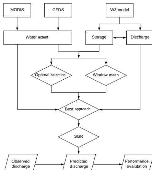
The fundamental assumption in our methodology is that there exist strong, monotonic relationships between remote sens-ing signal, surface water extent, river channel storage, and river discharge. Surface water extent fraction (hereafter, wa-ter extent) was previously derived from Global Flood Detec-tion System (GFDS) passive microwave and MODIS optical remote sensing signal by Van Dijk et al. (2016). River stor-age and discharge were estimated by the World-Wide Water (W3) model version 2 (Van Dijk et al., 2018). First, we de-signed two alternative methods to develop SGRs with the aid of hydrological model estimates and compared performance of these methods on rivers of different sizes. We then applied the method that performed best across the Amazon Basin. Second, SGRs were constructed across the Amazon Basin based on MODIS and GFDS water extent. The derived river discharge estimates from the SGRs and from the W3 model were evaluated against in situ river discharge measurements at 31 stations. The overall methodology is shown in Fig. 1.
2.1 Study region
Figure 1. Workflow of the overall methodology (rectangle: data; diamond: method; parallelogram: validation).
our method in that it contains numerous inaccessible river reaches surrounded by dense tropical rainforests, frequently flooded areas, extremely wide river floodplains, and braided river channels. Moreover, it has unregulated rivers of widely varying size, which provides an opportunity to assess the sen-sitivity of spatial resolution in remote sensing to river size. In addition, because rainfall estimates across the Amazon Basin are generally poor, it is meaningful to test whether modelled discharge can be improved through remote sensing. A chal-lenge is that MODIS observations are often affected by cloud cover. Van Dijk et al. (2016) found strong correlations be-tween optical and passive microwave-derived water extent estimates and station discharge observations in the Amazon Basin, from which we infer that there may be further oppor-tunities to develop satellite-based river gauging using mod-elled discharge at ungauged sites.
2.2 Data
2.2.1 Remote sensing
The Global Flood Detection System (GFDS) was developed to monitor floods and is operated by the Joint Research Cen-tre of the European Commission, in collaboration with the Dartmouth Flood Observatory. De Groeve et al. (2015) pro-posed a discharge signal,s, as the ratio of brightness temper-atures between a targeted wet pixel (measurement pixel) and
a nearby dry pixel (calibration pixel), which allows track-ing of relative changes in surface water extent within a river reach. The discharge signals was calculated from bright-ness temperature recorded at 36.5 GHz in the H polarization by the Japanese Space Agency’s AMSR2 and TRMM TMI sensors and NASA’s AMSR-E and GPM instruments. The GFDS raster data product used here, named “merged 4-day average datasets”, provides dailysas an average value of the signal for the current day and the signal from the last 3 days, with a spatial resolution of 0.09◦×0.1◦over the period of 2000–2014.
MODIS is an optical sensor aboard the NASA’s Terra and Aqua satellites, which provide two images per day for almost every point on the planet. The surface observing capability of MODIS is limited by cloud cover, but this can be miti-gated by using MODIS 8-day or 16-day composites which reduce the influence of cloud contamination. The MODIS data used here are the shortwave infrared (SWIR) spec-tral band 7 (2105–2155 nm) data from the MCD43C4.005 product which contains 8-day nadir BRDF (bidirectional re-flectance distribution function) adjusted rere-flectance (NBAR) composites of imagery over the period of 2000–2014. The optical data were aggregated to a spatial resolution of 0.05◦×
0.05◦. The method to calculate surface water extent fraction from GFDS and MODIS data was described by Van Dijk et al. (2016). We calculated both 8-day and monthly GFDS-and MODIS-derived surface water extent fraction across the Amazon Basin.
2.2.2 Hydrological model
chan-nel storage, rather than discharge, are compared with optical and passive microwave-derived water extents because con-ceptually they are more closely related. However, river chan-nel storage has a linear relationship with discharge within the W3 model structure.
2.2.3 In situ river discharge measurement
Monthly in situ river discharge measurements were collected from two datasets developed by Beck et al. (2015) and Dai (2016) respectively. The former dataset was established to combine global unregulated river discharge data from the Global Runoff Data Centre (GRDC) and the USGS GAGES II (Geospatial Attributes of Gauges for Evaluating Stream-flow) databases. The same data were used in a precursor to this study (Van Dijk et al., 2016). The latter dataset was de-veloped to compile river flow data from the farthest down-stream gauging stations of the world’s largest 925 rivers. Among these two datasets there are 31 gauging stations lo-cated inside the Amazon Basin with records that were fully or partially overlapping with the remote sensing and model simulation records.
2.3 Method
2.3.1 Satellite gauging reach designs and performance evaluations
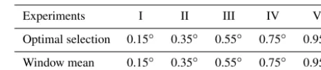
In developing SGRs, we tested two alternative methods to correlate remotely sensed water extent with modelled river channel storage. Method A finds the most strongly correlated water extent over a search window, which we refer to here as optimal grid cell selection. Method B calculates the spa-tial average water extent within a search window, referred to here as the window mean. We experimented with different window sizes: 0.15◦×0.15◦, 0.35◦×0.35◦, 0.55◦×0.55◦, 0.75◦×0.75◦, and 0.95◦×0.95◦(Table 1). These 10 exper-iments (two methods for each of the five search windows) were applied for each grid cell of the W3 model along a river channel across the Amazon Basin, using 8-day MODIS- and GFDS-derived water extent estimates, respectively. For each grid cell, the steps are as follows: a search window centres on a target grid cell of the W3 model, and simulated storage time series for the target cell and all water extent time series lo-cated within the search window are selected. Next, in method A, the storage time series is compared with each water extent time series, and the one with the strongest correlation is cho-sen to develop the SGR. In method B, spatial average water extent time series across the window is calculated and used to develop the SGR.
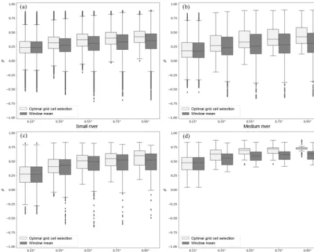
[image:4.612.311.543.96.147.2]To test which of the two methods best estimates storage for different river sizes, we divided river reaches into four categories based on their mean simulated discharge over the period 2000–2014. The four categories of river were de-fined as small (102–103m3s−1), medium (103–104m3s−1),
Table 1.Experiment design (window size) for two methods to de-velop SGRs.
Experiments I II III IV V
Optimal selection 0.15◦ 0.35◦ 0.55◦ 0.75◦ 0.95◦
Window mean 0.15◦ 0.35◦ 0.55◦ 0.75◦ 0.95◦
large (104–105m3s−1), and very large (>105m3s−1) rivers (Fig. 2). We did not consider rivers where discharge is less than 102m3s−1 as we assume that they would have chan-nel widths that could not be resolved using our sensing and modelling methods. The most suitable window overall and the SGR selection method were subsequently decided upon based on performance statistics.
The superior method was applied to construct SGRs across the Amazon Basin, using 8-day MODIS and GFDS water ex-tent, respectively. For method A, the time series was split into training and validation periods to ensure independent valida-tion. Data for the training period were used to select the best correlating pixel for each model grid cell, while data from the validation period were used to evaluate SGRs’ performance. We evaluated the results from three experiments: (I) train-ing: 2005–2014, validation: 2000–2004; (II) traintrain-ing: 2000– 2004 and 2010–2014, validation: 2005–2009; and (III) train-ing: 2000–2009, validation: 2010–2014 (Table 2). The mean result was adapted as the overall evaluation statistic. For method B, spatial average water extent for the whole period of 2000–2014 was compared to storage directly, as this pro-duces the same results as using the cross-validation method. The performance of SGRs was assessed using Spearman’s rank correlation (ρ), since the relationship between water ex-tent and storage is often non-linear.
2.3.2 Evaluations of satellite gauging reaches and the W3 model
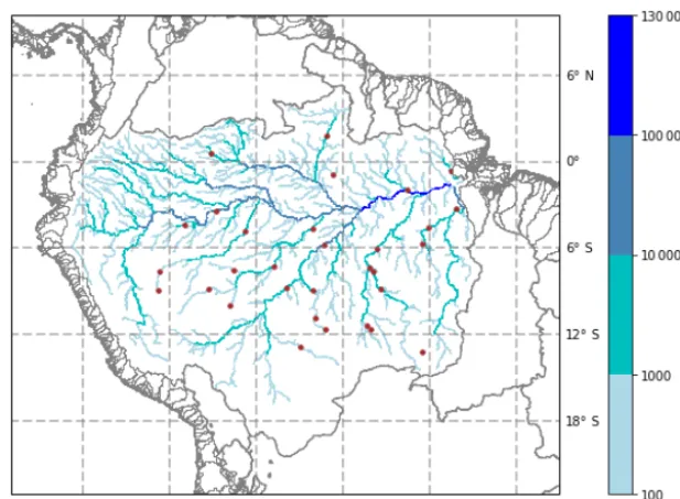
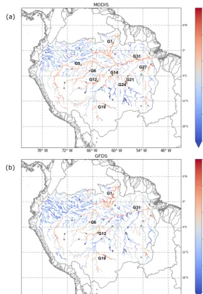
func-Figure 2.The W3 model simulated mean river discharges (>100 m3s−1) in the Amazon Basin (grey line: basin boundary; brown dot: gauging station).
Table 2.Training and validation periods for the cross-validation method.
Periods I II III
Training period 2005–2014 2000–2004 & 2010–2014 2000–2009 Validation period 2000–2004 2005–2009 2010–2014
tion (CDF) matching. Following the approach of Van Dijk et al. (2016), we used a rank-based look-up-table approach to estimate river discharge from mapped water extent. Esti-mates of water extent in the validation period are ranked rel-ative to the estimate water extents in the training period, and CDF matching is then used to provide corresponding river discharge estimates over the validation period. The combi-nation of river discharge estimates from the three validation periods was lumped to represent performance over the whole study period of 2000–2014. Overall, we obtained three river discharge estimates from MODIS, GFDS, and the model. All were then validated and evaluated against monthly in situ river discharge measurement (daily in situ data were not available for most stations).
3 Results
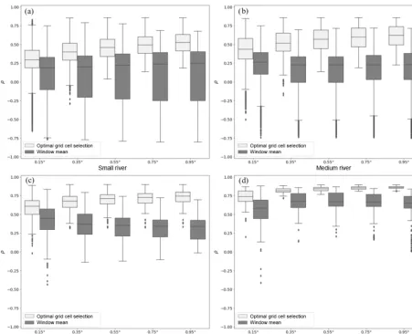
3.1 Evaluations of satellite gauging reach designs The 10 experiments described in Sect. 2.3.1 for relating re-motely sensed water extent to simulated river channel storage were compared, using MODIS and GFDS water extent, re-spectively. For MODIS, irrespective of window size or SGR
selection method, the meanρbetween water extent and stor-age increases and the range ofρ narrows as discharge be-comes larger (Fig. 3). For the small rivers (102–103m3s−1), the optimal selection method (method A) achieved mean
Figure 3.Distributions of Spearman’s rank correlation between MODIS water extent and simulated storage using different window sizes (0.15◦×0.15◦, 0.35◦×0.35◦, 0.55◦×0.55◦, 0.75◦×0.75◦, and 0.95◦×0.95◦) and two approaches (light grey: optimal grid cell selection (method A); dark grey: window mean (method B)) in four categories of river flow across the Amazon Basin. Outliers are data beyond the distance larger than 1.5 times the interquartile range from the first and third quartiles.
This approach was applied across the Amazon Basin us-ing MODIS and GFDS water extent respectively (Fig. 5a–b). For MODIS SGRs, there were strong relationships (ρ >0.6) between water extent and storage in most reaches of the main river channel and its large tributaries, particularly in the larger channels (ρ >0.8), while there were weak correlations (ρ <0.4) in upstream tributaries. The overall performance of the MODIS SGRs was superior to the GFDS SGRs. For GFDS SGRs, there were more river reaches with low correla-tions (ρ <0.4) in upstream tributaries, and the lower reach of the Amazon River did not show continuous high correlations (ρ >0.8).
3.2 Performance of satellite gauging reaches and the W3 model
Figure 4.Distributions of Spearman’s rank correlation between GFDS water extent and simulated storage using different window sizes (0.15◦×0.15◦, 0.35◦×0.35◦, 0.55◦×0.55◦, 0.75◦×0.75◦, and 0.95◦×0.95◦) and two approaches (light grey: optimal grid cell selection (method A); dark grey: window mean (method B)) in four categories of river flow across the Amazon Basin. Box plots are defined as in Fig. 3.
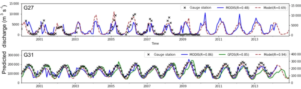
and model on the left axis). The W3 model yielded good es-timates, with Pearson correlation (R) generally greater than 0.8 across most sites. A total of 7 of the 10 MODIS SGRs estimated river discharge withRabove 0.7, and the SGR for gauging stations G12 and G31 performed best, withRclose to 0.9. Overall, MODIS SGRs estimates were not as skilful as the model, with the exception of the one for gauging sta-tion G12. While there were fewer potential sites for GFDS SGRs, they were similarly or more skilful than the MODIS SGRs. For gauging stations G12 and G19, GFDS produced better river discharge estimates than either MODIS or the W3 model. Overall, estimated river discharges from the SGRs and the model showed similar flow fluctuations to in situ river discharge observations. The performance of daily, 8-day, and monthly MODIS and GFDS SGRs are compared and dis-cussed in the Supplement (Fig. S1).
4 Discussion
Figure 5.Spearman correlation (ρ) between modelled river channel storage and MODIS(a)and GFDS(b)water extent using the optimal grid cell selection method (method A) with a search window of 0.55◦×0.55◦(circle: gauging station; circle with label: potential SGR sites where gauging data are available).
have a spatial resolution of 0.05◦×0.05◦, which is higher than the GFDS data (0.09◦×0.1◦). As such, MODIS should have better detection ability for river reaches with relatively small surface water extent. The performance of the method appears to be particularly related to the size of river reach. From upstream to downstream reaches in the Amazon Basin,
ρ between water extent and storage increases as river width increases, because MODIS and GFDS remote sensing are more sensitive to river reaches with larger surface water ex-tent. Thus, the best locations for developing SGRs at the coarse resolution considered here are the lower reaches of the Amazon system.
Figure 6.Comparisons between observations (right axis) from gauging stations (black x) and river discharge estimates (left axis) derived using MODIS SGRs (blue line), GFDS SGRs (green line), and the W3 model (brown dash).
to clear-sky conditions, whereas GFDS passive microwave remote sensing is much less affected by this. River flood-plains in the Amazon Basin are often covered with dense vegetation, and flood waters may spread below vegetation. Such flooding may be difficult to detect with optical imagery, but is still readily discernible with passive microwave remote sensing (Van Dijk et al., 2016). This is consistent with the results presented in Figs. 3 and 4. The window mean method (method B) produced similar results to the optimal selec-tion method (method A) for GFDS, but worse results for MODIS. We suspect that this is because more MODIS grid cells within the search window are influenced by cloud or vegetation cover.
Gauging stations are usually located in single, narrow, and stable river reaches, while SGRs can be constructed in mul-tiple, broad, and unstable river reaches provided variations can be detected by remote sensing. With that caveat, there were less than one-third of gauged river reaches that were feasible to develop MODIS SGRs and one-sixth to construct GFDS SGRs. Limited validation reaches with gauging sta-tions do imply an underestimate of the percentage of suc-cessful SGRs. We focused on qualitative analysis rather than quantitative analysis for the performance of SGRs and the model. Qualitative metrics, such as Pearson correlation and Spearman’s rank correlation, indicate the degree to which the estimates and observations show the same relative patterns, while quantitative metrics, such as RMSE, reflect the differ-ences between estimates and observations. The SGRs were based on the model, so we would expect that the developed SGRs should have the ability to reflect flow patterns better than absolute flow values due to model biases. Tolerable er-rors and bias are contingent on the application for the data. For instance, for near-real-time drought and flood monitor-ing, it may be sufficient to know relative flows, whereas water resource assessments require estimates that are bias-free as much as possible. For the 10 gauging stations analysed here, the model showed a bias between−53 % and 57 % compared
to the gauge records, with a median of−35 %. This model bias propagates into the SGR estimates but could be removed easily where in situ data are available.
Based on comparison between gauging station records and river discharge estimates from MODIS, GFDS, and the W3 model for period of 2000–2014, we conclude that if the W3 model performs quite well in terms of river discharge estima-tion, then SGRs can perform with a similar level of accuracy. In certain cases, the SGRs were able to perform better than the W3 model in reproducing the timing of peak flows. For instance, at gauging station G19, the satellite-derived peak flows from both MODIS and GFDS over the period 2000– 2005 were closer to gauged peak river discharges than those estimated by the W3 model (Fig. 6). However, there are also instances where the SGR estimates of discharge are inferior to those produced by the W3 model, e.g. for gauging stations G21 and G24. It is possible that in these instances MODIS has failed to measure water extent in small rivers or was af-fected by cloud cover. In other cases we suspect that poor results are attributable to data errors. For instance, the dis-charge observations at gauging station G27 were extremely low from late 2008 to 2009, suggesting a gauge measurement error or other artefact. Other performance problems may be attributable to the calibration processes and period, which were necessarily short. If SGRs were calibrated during a dry period, they may fail to estimate river discharge well during a wet period (and vice versa). For example, at gauging sta-tion G27, the SGR was not able to estimate peak flows accu-rately for the wet years from 2005–2009, and subsequently estimated much larger river discharges than the model dur-ing the dry years 2010–2014. This would be avoided if the full period had been used for SGR construction, which would be a pragmatic approach for operational implementation but would prevent independent evaluation in the context of the present study.
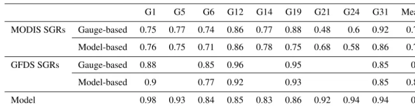
re-Table 3. Performance comparisons between gauge-based SGRs, model-based SGRs, and the W3 model (Pearson correlations between predicted and observed discharges).
G1 G5 G6 G12 G14 G19 G21 G24 G31 Mean
MODIS SGRs Gauge-based 0.75 0.77 0.74 0.86 0.77 0.88 0.48 0.6 0.92 0.75
Model-based 0.76 0.75 0.71 0.86 0.78 0.75 0.68 0.58 0.86 0.75
GFDS SGRs Gauge-based 0.88 0.85 0.96 0.95 0.85 0.9
Model-based 0.9 0.77 0.92 0.93 0.85 0.87
Model 0.98 0.93 0.84 0.85 0.83 0.86 0.92 0.94 0.94 0.9
mote sensing signal for estimating river discharge (Braken-ridge et al., 2012; Revilla-Romero et al., 2014). Van Dijk et al. (2016) developed gauge-based SGRs using optical and passive microwave-derived water extent observations, which is valuable to gap-fill and extend gauging discharge records. In addition to that, we demonstrated that SGRs can be also developed using hydrological modelling. We compared our model-based SGRs to gauge-based SGRs from previous re-search (Van Dijk et al., 2016) for all gauging reaches, except gauging station G27 due to its seemingly unreliable record (Table 3). Both gauge-based and model-based GFDS SGRs at gauging station G12 and G19 have higher Pearson corre-lations than the model, which suggests opportunities for data assimilation to improve the model. At gauging station G1, G5, G21, and G24, the model performs much better than both gauge-based and model-based SGRs, which suggests that un-certainties in SGRs at these locations mainly arise from re-mote sensing, e.g. due to cloud and vegetation obstruction. Errors and uncertainties in the model, such as from input data, routing, and conceptual structure, can also affect the performance of SGRs. For instance, for GFDS at gauging station G6 and MODIS at gauging station G31, gauge-based SGRs produced higher Pearson correlations than model-based SGRs. Compared to gauge-model-based SGRs, the main ad-vantage of our method is the practical applicability in both gauged and ungauged rivers. Our results show that the model outperforms SGRs in most cases. Nonetheless, we consider SGRs as an alternative, simple and automated approach for river discharge prediction using satellite observation only. SGRs would be useful as an alternative if the model was unable to provide real-time estimates, e.g. due to delayed rainfall gauge observations. As we used a model to train SGRs, poor model simulations might reduce the performance of SGRs. If more accurate and reliable hydrological mod-els are available, SGRs can be redeveloped to estimate river discharge with greater accuracy. Overall, SGRs performed well in this case study in the Amazon Basin. The W3 model, MODIS and GFDS remote sensing all provide information with global coverage. Therefore, there is further potential to develop satellite-based river gauging elsewhere.
The further development of the SGR methodologies could benefit from combining optical and passive microwave re-mote sensing. With higher spatial resolution, optical rere-mote sensing is more suitable for measuring surface water extent in reaches without dense vegetation and when clear-sky con-ditions prevail. Passive microwave remote sensing compen-sates for the limitations of optical remote sensing, but suffers from having lower spatial resolution. The main constraint in developing SGRs in this study was that the spatial resolutions of both MODIS and GFDS data were not high enough to de-tect changes in river dynamics in small rivers. New satellite imagery emerging from Sentinel-1 and Sentinel-2 provides further opportunities to develop satellite-based river gaug-ing at a global scale. The spatial resolution of Sentinel-1 reaches 5 m with C-band synthetic aperture radar working in all weather and both day-time and night-time conditions. The Sentinel-2 A and B multispectral instruments have 13 spectral bands at 10–60 m spatial resolution and, combined with Landsat observations, this means that revisit times in the order of days are now achievable. These developments offer great promise for the future development of SGRs.
5 Conclusions
We proposed and tested two methods for relating MODIS-and GFDS-derived water extent to modelled river channel storage. For the Amazon Basin, river reaches with Spear-man’s rank correlation (ρ) between water extent and storage exceeding 0.6 were identified as suitable sites for developing SGRs. SGRs were then constructed across the Amazon Basin based on MODIS and GFDS water extent and modelled dis-charge, and river discharge estimates were evaluated using in situ river discharge measurements at 10 stations. Our main conclusions are as follows:
[image:11.612.94.500.96.200.2]2. There were strong correlations between modelled stor-age and both MODIS and GFDS water extent across the Amazon Basin. The optimal selection method is mainly limited by the size of river reach, as correlation gener-ally increased from upstream to downstream reaches as river width increased.
3. In total, 17 135 km of river reaches in the Amazon Basin was assessed as suitable for constructing MODIS SGRs, and 7235 km of river reaches was deemed suitable for developing GFDS SGRs. The best locations for devel-oping SGRs were mostly situated in the lower channels of the Amazon River and its main tributaries.
4. There were more potential SGRs derived using MODIS than GFDS, most likely because MODIS has higher spatial resolution than GFDS. However, GFDS SGRs predicted river discharges with more accuracy as GFDS was much less affected by cloud and dense vegetation than MODIS.
5. Although the W3 model performed very well in terms of river discharge estimates in the Amazon Basin, MODIS and GFDS SGRs can still be useful for estimating river discharge in the absence of a real-time hydrological model or gauging stations.
6. SGRs are suitable for automated development at a global scale. Remote sensing with higher spatial reso-lution can help improve river discharge estimation ca-pabilities of SGRs. This also creates potential opportu-nities to assimilate remote sensing observations, or de-rived discharge estimates, into hydrological models to improve river discharge estimation, and based on these, streamflow forecasts.
Data availability. All hydrological model and remote sensing-derived surface water extent data used here can be accessed via http://wald.anu.edu.au/data/ (last access: 20 September 2018).
Supplement. The supplement related to this article is available online at: https://doi.org/10.5194/hess-22-6435-2018-supplement.
Author contributions. JH and AIJMVD conceived the idea. AI-JMVD, LJR and RAV guided the study. JH carried out the analysis and wrote the manuscript with contributions from all the co-authors.
Competing interests. The authors declare that they have no conflict of interest.
Special issue statement. This article is part of the special issue “In-tegration of Earth observations and models for global water re-source assessment”. It is not associated with a conference.
Acknowledgements. The authors acknowledge the Global Runoff Data Centre (GRDC) and the U.S. Geological Survey (USGS) for providing the in situ river discharge measurement, and Hylke Beck and Aiguo Dai for compiling the discharge data. The first author thanks the ANU-CSC (the Australian National University and the China Scholarship Council) Scholarship for supporting his PhD study at the Australian National University. Calculations were performed on the high-performance computing system, Raijin, from the National Computational Infrastructure (NCI), supported by the Australian Government’s National Collaborative Research Infrastructure Strategy (NCRIS). We also thank Florian Pappen-berger, Christel Prudhomme, and three anonymous reviewers for their helpful suggestions that improved the manuscript.
Edited by: Florian Pappenberger
Reviewed by: Christel Prudhomme and three anonymous referees
References
Alsdorf, D., Lettenmaier, D., and Vörösmarty, C.: The need for global, satellite-based observations of terrestrial sur-face waters, EOS T. Am. Geophys. Un., 84, 269–276, https://doi.org/10.1029/2003EO290001, 2003.
Alsdorf, D. E., Rodriguez, E., and Lettenmaier, D. P.: Measur-ing surface water from space, Rev. Geophys., 45, RG2002, https://doi.org/10.1029/2006RG000197, 2007.
Beck, H. E., de Roo, A., and van Dijk, A. I. J. M.: Global Maps of Streamflow Characteristics Based on Observations from Sev-eral Thousand Catchments, J. Hydrometeorol., 16, 1478–1501, https://doi.org/10.1175/jhm-d-14-0155.1, 2015.
Biancamaria, S., Hossain, F., and Lettenmaier, D. P.: Forecasting transboundary river water elevations from space, Geophys. Res. Lett., 38, L11401, https://doi.org/10.1029/2011GL047290, 2011. Birkett, C. M., Mertes, L. A. K., Dunne, T., Costa, M. H., and Jasin-ski, M. J.: Surface water dynamics in the Amazon Basin: Appli-cation of satellite radar altimetry, J. Geophys. Res.-Atmos., 107, 8059, https://doi.org/10.1029/2001JD000609, 2002.
Bjerklie, D. M., Dingman, S. L., Vorosmarty, C. J., Bolster, C. H., and Congalton, R. G.: Evaluating the potential for mea-suring river discharge from space, J. Hydrol., 278, 17–38, https://doi.org/10.1016/S0022-1694(03)00129-X, 2003. Brakenridge, G. R., Nghiem, S. V., Anderson, E., and
Mic, R.: Orbital microwave measurement of river dis-charge and ice status, Water Resour. Res., 43, W04405, https://doi.org/10.1029/2006WR005238, 2007.
Brakenridge, G. R., Cohen, S., Kettner, A. J., De Groeve, T., Nghiem, S. V., Syvitski, J. P. M., and Fekete, B. M.: Calibration of satellite measurements of river discharge us-ing a global hydrology model, J. Hydrol., 475, 123–136, https://doi.org/10.1016/j.jhydrol.2012.09.035, 2012.
Calmant, S. and Seyler, F.: Continental surface waters from satellite altimetry, C. R. Geosci., 338, 1113–1122, https://doi.org/10.1016/j.crte.2006.05.012, 2006.
Dai, A.: Historical and future changes in streamflow and continen-tal runoff: a review, in: Chapter 2 of Terrestrial water cycle and climate change: natural and human-induced impacts, edited by: Tang, Q. and Oki, T., Geophysical Monograph, Am. Geophys. Un., 17–37, 2016.
Dai, A., Qian, T., Trenberth, K. E., and Milliman, J. D.: Changes in continental freshwater discharge from 1948 to 2004, J. Climate, 22, 2773–2792, https://doi.org/10.1175/2008JCLI2592.1, 2009. De Groeve, T., Brakenridge, G. R., and Paris, S.: Global flood
detection system data product specifications, JRC Techni-cal Report, available at: http://www.gdacs.org/flooddetection/ Download/Technical_Note_GFDS_Data_Products_v1.pdf (last access: 20 September 2018), 2015.
Fekete, B. M., Looser, U., Pietroniro, A., and Robarts, R. D.: Ra-tionale for monitoring discharge on the ground, J. Hydrometeo-rol., 13, 1977–1986, https://doi.org/10.1175/JHM-D-11-0126.1, 2012.
Frost, A. J., Ramchurn, A., and Smith, A.: The Bureau’s Operational AWRA Landscape (AWRA-L) Model, Technical Report, Bureau of Meteorology, Melbourne, 2016.
Hunger, M. and Döll, P.: Value of river discharge data for global-scale hydrological modeling, Hydrol. Earth Syst. Sci., 12, 841– 861, https://doi.org/10.5194/hess-12-841-2008, 2008.
Jung, H. C., Hamski, J., Durand, M., Alsdorf, D., Hossain, F., Lee, H., Hossain, A. K. M. A., Hasan, K., Khan, A. S., and Hoque, A. K. M. Z.: Characterization of complex fluvial systems using remote sensing of spatial and temporal water level variations in the Amazon, Congo, and Brahmaputra Rivers, Earth Surf. Proc. Land., 35, 294–304, https://doi.org/10.1002/esp.1914, 2010. Khan, S. I., Hong, Y., Vergara, H. J., Gourley, J. J.,
Braken-ridge, G. R., De Groeve, T., Flamig, Z. L., Policelli, F., and Yong, B.: Microwave satellite data for hydrologic modeling in ungauged basins, IEEE Geosci. Remote S., 9, 663–667, https://doi.org/10.1109/LGRS.2011.2177807, 2012.
Kouraev, A. V., Zakharova, E. A., Samain, O., Mognard, N. M., and Cazenave, A.: Ob’river discharge from TOPEX/Poseidon satel-lite altimetry (1992–2002), Remote Sens. Environ., 93, 238–245, https://doi.org/10.1016/j.rse.2004.07.007, 2004.
LeFavour, G. and Alsdorf, D.: Water slope and discharge in the Amazon River estimated using the shuttle radar topography mis-sion digital elevation model, Geophys. Res. Lett., 32, L17404, https://doi.org/10.1029/2005GL023836, 2005.
Michailovsky, C. I., McEnnis, S., Berry, P. A. M., Smith, R., and Bauer-Gottwein, P.: River monitoring from satellite radar altime-try in the Zambezi River basin, Hydrol. Earth Syst. Sci., 16, 2181–2192, https://doi.org/10.5194/hess-16-2181-2012, 2012. Moffitt, C. B., Hossain, F., Adler, R. F., Yilmaz, K. K., and Pierce,
H. F.: Validation of a TRMM-based global Flood Detection System in Bangladesh, Int. J. Appl. Earth Obs., 13, 165–177, https://doi.org/10.1016/j.jag.2010.11.003, 2011.
Papa, F., Prigent, C., and Rossow, W.: Monitoring flood and discharge variations in the large Siberian rivers from a multi-satellite technique, Surv. Geophys., 29, 297–317, https://doi.org/10.1007/s10712-008-9036-0, 2008.
Papa, F., Durand, F., Rossow, W. B., Rahman, A., and Bala, S. K.: Satellite altimeter-derived monthly discharge of the Ganga-Brahmaputra River and its seasonal to interannual variations from 1993 to 2008, J. Geophys. Res.-Oceans, 115, C12013, https://doi.org/10.1029/2009JC006075, 2010.
Pavelsky, T. M.: Using width-based rating curves from spatially dis-continuous satellite imagery to monitor river discharge, Hydrol. Process., 28, 3035–3040, https://doi.org/10.1002/hyp.10157, 2014.
Revilla-Romero, B., Thielen, J., Salamon, P., De Groeve, T., and Brakenridge, G. R.: Evaluation of the satellite-based Global Flood Detection System for measuring river discharge: influ-ence of local factors, Hydrol. Earth Syst. Sci., 18, 4467–4484, https://doi.org/10.5194/hess-18-4467-2014, 2014.
Smith, L. C.: Satellite remote sensing of river inunda-tion area, stage, and discharge: A review, Hydrol. Pro-cess., 11, 1427–1439, https://doi.org/10.1002/(SICI)1099-1085(199708)11:10<1427::AID-HYP473>3.0.CO;2-S, 1997. Smith, L. C. and Pavelsky, T. M.: Estimation of river
dis-charge, propagation speed, and hydraulic geometry from space: Lena River, Siberia, Water Resour. Res., 44, W03427, https://doi.org/10.1029/2007WR006133, 2008.
Smith, L. C., Isacks, B. L., Forster, R. R., Bloom, A. L., and Preuss, I.: Estimation of discharge from braided glacial rivers using ERS 1 synthetic aperture radar: First results, Water Resour. Res., 31, 1325–1329, https://doi.org/10.1029/95WR00145, 1995. Smith, L. C., Isacks, B. L., Bloom, A. L., and Murray, A.
B.: Estimation of discharge from three braided rivers using synthetic aperture radar satellite imagery: Potential applica-tion to ungaged basins, Water Resour. Res., 32, 2021–2034, https://doi.org/10.1029/96WR00752, 1996.
Stahl, K., Tallaksen, L. M., Hannaford, J., and van Lanen, H. A. J.: Filling the white space on maps of European runoff trends: esti-mates from a multi-model ensemble, Hydrol. Earth Syst. Sci., 16, 2035–2047, https://doi.org/10.5194/hess-16-2035-2012, 2012. Tarpanelli, A., Brocca, L., Lacava, T., Melone, F., Moramarco,
T., Faruolo, M., Pergola, N., and Tramutoli, V.: Toward the estimation of river discharge variations using MODIS data in ungauged basins, Remote Sens. Environ., 136, 47–55, https://doi.org/10.1016/j.rse.2013.04.010, 2013.
Te Chow, V.: Open-channel hydraulics, McGraw-Hill, New York, 1959.
Van Dijk, A. I. J. M.: The Australian Water Resources As-sessment System. Technical Report 3. Landscape Model (version 0.5) Technical Description, CSIRO: Water for a Healthy Country National Research Flagship, available at: http://www.clw.csiro.au/publications/waterforahealthycountry/ 2010/wfhc-aus-water-resources-assessment-system.pdf (last access: 20 September 2018), 2010.
Van Dijk, A. I. J. M.: Water resources, climate change and energy, in: Climate, Energy and Water: Managing Trade-offs, Seizing Opportunities, edited by: Pittock, J., Hussey, K., and Dovers, S., Cambridge, Cambridge University Press, 6–27 pp., 2015. Van Dijk, A. I. J. M., Brakenridge, G. R., Kettner, A. J.,
Beck, H. E., De Groeve, T., and Schellekens, J.: River gauging at global scale using optical and passive mi-crowave remote sensing, Water Resour. Res., 52, 6404–6418, https://doi.org/10.1002/2015WR018545, 2016.
Vörösmarty, C., Askew, A., Grabs, W., Barry, R. G., Birkett, C., Döll, P., Goodison, B., Hall, A., Jenne, R., Kitaev, L., Landwehr, J., Keeler, M., Leavesley, G., Schaake, J., Strzepek, K., Sun-darvel, S. S., Takeuchi, K., and Webster, F.: Global water data: A newly endangered species, EOS T. Am. Geophys. Un., 82, 54– 58, https://doi.org/10.1029/01EO00031, 2001.
Woldemichael, A. T., Degu, A. M., Siddique-E-Akbor, A. H. M., and Hossain, F.: Role of Land–Water Classification and Man-ning’s Roughness Parameter in Space-Borne Estimation of Dis-charge for Braided Rivers: A Case Study of the Brahmapu-tra River in Bangladesh, IEEE J. Sel. Top. Appl., 3, 395–403, https://doi.org/10.1109/JSTARS.2010.2050579, 2010.