PART I: Land Transport Infrastructure Subproject (St. Martin Road)
Project Number: 41171-02 November 2010
SOL: Transport Sector Development Project
Scope and Technical Report
ABBREVIATIONS ADB – Asian Development Bank ADT – average daily traffic
AS – Australian Standard
Ch – Chainage
CPIU – Central Project Implementation Unit EIRR – economic internal rate of return
LBES – labor-based, equipment-supported MID – Ministry of Infrastructure Development
PPTA – project preparatory technical assistance SI$ – Solomon Islands dollar
TABLE OF CONTENTS
Page
I. SUMMARY FACT SHEET 1
II. INTRODUCTION 1
III. DESCRIPTION OF THE SAMPLE ROAD SUBPROJECT 2
A. LOCATION AND SITE 2
B. EXISTING ROAD CONDITIONS 3
C. SURVEYS 4
D. TRAFFIC FLOWS 5
E. PROJECT OBJECTIVE 6
F. PROPOSED REHABILITATION WORKS 6
IV. RELIMINARY ENGINEERING DESIGN 7
A. FUNCTIONAL REQUIREMENTS 7
B. DESIGN STANDARDS AND CONSIDERATIONS 7
C. ROAD SAFETY CONSIDERATIONS 14
D. IMPLEMENTATION STRATEGY AND PROJECT RISKS 15
E. REHABILITATION COSTS 16 F. MAINTENANCE COSTS 17 ATTACHMENT 1 19 ATTACHMENT 2 36 ATTACHMENT 3 40 ATTACHMENT 4 56
I. SUMMARY FACT SHEET
Province/Island Guadalcanal Province
Location 6 km east of Honiara International Airport Project St. Martin Road Rehabilitation (8.5 km)
Connectivity Feeder Road connecting to Honiara-Aola Main Road and servicing access to two schools, a clinic, a community centre, several villages and market gardens
Existing structure type Gravel road
Existing traffic Appr. 50 vehicles per day Projected traffic, 2030 Appr. 100-110 vehicles per day Estimated traffic growth rate 2.0% - 3.0% p.a.
Proposed improvement Spot improvements, reshape pavement, drainage provision and maintenance Estimated Cost; Rehabilitation
Maintenance
App. $ 487,000 (SI$ 3,848,900)
App. $ 24,500 per annum (SI$ 194,000) Environmental Impacts See initial environmental examination
Social Impacts Provide public transport access and improve social cohesion. Induce residential development. See PSA.
II. INTRODUCTION
1. This subproject is to rehabilitate St. Martin Road, a feeder road leading from Honiara-Aola Main Road (Kukum Highway), east of the Honiara International airport, to a more serviceable and maintainable condition. This road is on the priority list of the Ministry of Infrastructure Development (MID) for reconstruction but has not been included in the recent road rehabilitation project list for tendering.
2. A preliminary analysis has been carried out by Solomon Islands Road Improvement Project (SIRIP)1 comparing the economic internal rate of return (EIRR) with a group of other feeder roads in the area requiring rehabilitation or upgrade based on limited secondary data. 3. This project preparatory technical assistance (PPTA)2 aims to establish a uniform methodology for a multi-criteria analysis to prioritise transport infrastructures including roads, wharfs and airstrips. This project has been identified to serve as a sample subproject.
1
ADB. 2006. Report and Recommendation of the President to the Board of Directors on Proposed Grants to Solomon Islands for the Road Improvement (Sector) Project. Manila (Grant 0048/0049/0050).
2
ADB. 2010. Technical Assistance to the Solomon Islands for Preparing the Transport Sector Development Project. Manila (TA 7335-SOL).
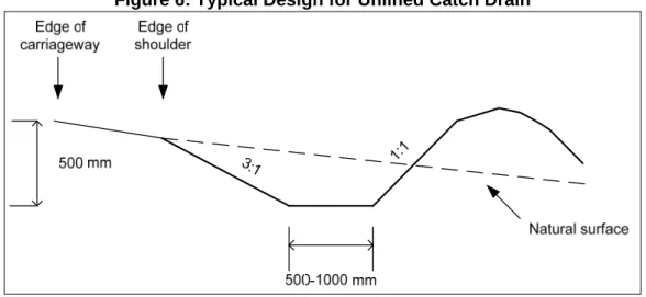
4. This paper documents the findings of a technical investigation and survey and produces preliminary design; proposal of works with an initial cost estimate to rehabilitate the road to a maintainable condition.
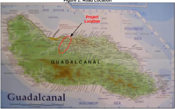
III. DESCRIPTION OF THE SAMPLE ROAD SUBPROJECT A. Location and Site
5. The proposed subproject for evaluation is St. Martin Road located at approximately 6km east from the Honiara International airport in Guadalcanal Province. The total length of the subject road is approximately 8.5 km, and it connects to the Honiara-Aola Main Road (Henderson Highway) in the north and attends near the School on the access road to the new Gold Ridge Relocation settlement area. The subject road provides access to St. Joseph’s High School, St Martin’s Technical School, a rice research farm, a clinic and several village settlements.
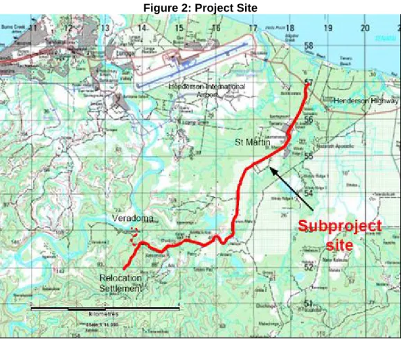
6. The location of the proposed sub-project is shown in Figure 1 below and the project site is shown in Figure 2.
Figure 2: Project Site
B. Existing Road Conditions
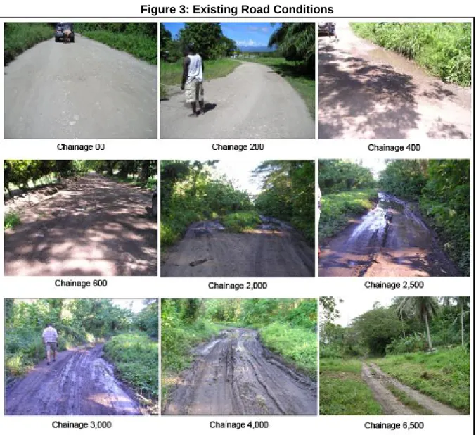
7. The length of the road is approximately 8.5 km measured from the edge of the road at Henderson highway to the Clinic on Gold Ridge Resettlement access road. The road pavement width varies from section to section. The first section from the Highway to St. Martin’s School (approximately 2.0 km) averages approximately 6.0 m. The next section between Chainage (Ch) 2,000 and 4,500 measures approximately between 4.0–4.5 m. The third section between Ch 4,500 and Ch 7,300 measures 4.0 m average. The last section of the access road ending at the school and clinic is a fairly recent development, and average 4.0 m.
8. The vertical alignment is relatively flat with occasional rolling sections. Locations where road damages occurred are mainly found at the bottom of depressions where water accumulates after rains.
9. The existing wearing course consists of river gravel mixed with sand and clay. Pavement thickness varies from section to section with an average of about 100–150 mm based on field observation and the condition survey carried out.
10. Results of the condition surveys undertaken by the PPTA team indicate that the riding conditions of the road varies from section to section along its length, with speeds well below 30 km/hour for most of the road due to large potholes and depressions filled with water. The damages are particularly severe where drainage provision is either absent or dysfunctional due to vegetation overgrowth or shoulder erosion and obstruction.
11.
Figure 3 below illustrates typical conditions of the road at various locations, including some severe damages to the road pavement. Details of the condition surveys are attached in Attachment 1.
Figure 3: Existing Road Conditions
C. Surveys
12. No previous survey information was available of the road, apart from some initial assessment of the scope of work by SIRIP for project prioritization purpose. For the purpose of this subproject engineering evaluation, the following surveys were identified and conducted.
(i) Road inventory and condition survey comprising visual inspections of topography, land use/vegetation, subsoil type, road surface type, access service level, road carriageway width, and road drainage condition. For this purpose, a road condition assessment form appended to this paper was designed and used (see Attachment 1).
(ii) Daily traffic and pedestrian counts (Note: Due to school holidays, traffic counts would not have provided reliable results. Thus, an estimation of current traffic amounts was made from questionnaire surveys conducted for social assessments).
Future surveys to be undertaken in connection with detailed design of its rehabilitation should be detailed, for establishing quantities of work, and should include detailed topographic surveys, and sub-base soil sampling.
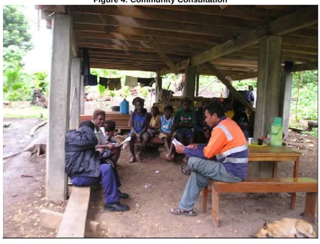
13. Figure 4 below shows the project engaged surveyor discussing aspects of field surveys with the local Village Chief.
Figure 4: Community Consultation
D. Traffic Flows
14. Most vehicles currently using the road beyond the first 2 km are four-wheel drive vehicles. Surveys indicated that buses, taxis and other commercial vehicles are reluctant to enter beyond the first 2 km. The current traffic volume (average daily traffic = ADT) of the road is estimated at 50 vehicles per day. The first 2 km of the road is more trafficked than the remainder due to the presence of schools, Church facilities and the rice research farm. The survey team also observed that there is a considerable amount of pedestrian traffic on the road, as many people are required to walk to the Henderson Highway in order to catch public transport to Honiara town centre and vice versa.
15. It is expected that traffic volumes will increase faster than the normal traffic growth rate on the section currently in poor condition, once the road is rehabilitated (access restored) and well-maintained. Based on the current level of traffic increase of approximately 2-2.5% p.a. on the Guadalcanal Island, and the expected additional traffic generation on the road, the ADT in 2030 can be projected at 100-110 vehicles per day.
E. Project Objective
16. The main objective of the road rehabilitation is to improve access to local communities within the zone of influence of the road, and businesses and public service facilities along the road. It is part of the overall objective of improving the road network in the Solomon Islands stipulated in the National Transport Plan. Short term benefits include better accessibility (for both vehicles and pedestrians), reduced road safety hazards and immediate improvement in facilitation of service delivery. In the longer term, the rehabilitated road is likely to attract land use developments such as market gardens and increased cash crop farming with prospects of increasing employment and community income.
17. The objective of the subproject is to reinstate road access.
F. Proposed Rehabilitation Works
18. The existing road can be brought to adequate maintainable condition through rehabilitation (spot improvements). The proposed rehabilitation works will allow continuing access for road users (vehicles and pedestrians) during all weather conditions. The proposed works include:
(i) For the first 2 km of the road, i.e. between the junction with Henderson highway and Chainage 2,000, provision of a new bituminous pavement, surface dressing/chip seal, maintaining the existing road width of 6.0 m with standard camber of c. 4%, and side drains, and cross drainage pipes (culverts) where required.
(ii) The key proposed works for the remaining 5.5 km of the road will include:
Scarifying, reshaping and re-grading of the existing road structure/ pavement, filling the depressions where required and adding a wearing course using river gravel hauled from the Lungga River.
Improving drainage by clearing all debris of existing drains, and where required, excavating and providing appropriate drainage structures.
Maintaining existing road alignment and road width of 4.5 m throughout. Provide a camber of 6% (after compaction). Reshaping the vertical alignment and lifting the road structure on low spots with provision of culverts where required.
19. A provision of a labour-based maintenance contract (say renewable every three years) is to be included with the following tasks:
(i) Vegetation control (clearing overgrowth blocking drainage channels and fall branches).
(ii) Removal of potholes and corrugations and re-grading and compacting the road surface
20. The maintenance tasks are to be carried out with appropriate intervals as suggested and shown in Table 7 in Section IV F.
IV. PRELIMINARY ENGINEERING DESIGN A. Functional Requirements
21. “Must Have”
Fulfill the principle of network connectivity ( roads and bridges must be part of an integrated network to serve areas of economic activities and improve access to services and income earning opportunities)
All weather accessibility
Appropriate geometric and structural design
Adequate drainage provision to withstand flows of large amounts of storm waters after severe storms and heavy rainfalls.
Considerations for environmental protection and adaptation to climate change. Adequate provision for maintenance after the rehabilitation (either included in the
rehabilitation Contractor’s contract or separately) 22. “Preferred to Have”
Appropriate provision for future road upgrading, due to road traffic increase
Appropriate traffic management provisions and road safety protection in the long term, e.g. guardrails, guide posts, hazard warning signs and devices.
B. Design Standards and Considerations
23. Apart from recommendations by design engineers of different road rehabilitation and re-construction projects, the no clearly adopted uniform national technical standards for road design exist in the Solomon Islands. The following considerations are recommended for future preparation of national standard design guidelines:
(i) Road widths for different traffic flow volumes – a minimum design standard should be considered for feeder and local roads carrying low traffic volumes. It would be appropriate to vary the design criteria in accordance with a road’s projected traffic, although it would be prudent to keep a uniform road reserve width for future upgrading needs.
(ii) Standard Cross section with sufficient camber – many low traffic unsealed roads do not have sufficient camber for the purpose of surface water draining from the road carriageway properly. The flat cross sections contribute to water locking and pavement damage by heavy rainfalls. Drainage considerations – standard cross drainage design for various drainage needs should be considered.
(iii) Standards for use of coral materials – see discussions later in this section.
(iv) Low cost bituminous pavement for upgrading roads with coral stone pavement – this consideration should be incorporated into the design standards for more heavily trafficked roads to reduce maintenance costs.
(v) Climate change adaptation measures – distance and levels from rivers or seaside should be considered in upgrading roads adjacent to river banks and in coastal areas to avoid climate change impacts.
24. The following text discusses design standards appropriate to the subproject and its equivalent road class.
1. Road Classification
25. There is no formal road classification in the Solomon Islands under the current Roads Act, although for functional purposes, roads in the Solomon Islands can generally be said to fall into three classes: Primary or Main Roads, Secondary Roads (or Feeder Roads) and Tertiary Roads (or Local Roads). Roads in urban areas (within the boundary of a township) are Urban Roads. Other roads fall into the Rural Roads category.
26. Based on the above definition, the subject road falls into the Feeder Road category, and as it is not within the urban boundary of Honiara, it is therefore a rural road.
27. Table 1 below shows a general functional road network classification in the Solomon Islands.
Table 1: Functional Road Classification
Road Class Function Typical Road Configurations
Primary Major thoroughfare, carrying inter regional traffic
2-4 lane sealed or unsealed roads
Secondary Feeder roads usually off the Primary Road network accessing to major developments, and providing access roads to residential villages or industries
2-lane roads either sealed or unsealed
Tertiary Local access road to small industrial, agricultural or residential areas
1-2 lane unsealed roads
2. Road Alignment
28. Based on the current and projected traffic usage of St. Martin road, no change is proposed in terms of horizontal alignment in connection with the rehabilitation.
29. In the longer term, if and when road realignment is required because of traffic growth and for road safety purposes, the design standards adopted in Papua New Guinea for rural roads with low traffic volumes may be referred to as shown in Table 2 below. However, it is suggested that design standards for the Solomon Islands will be created, and adequate technical, economic and other country-specific considerations may be made.
Table 2: Design Standards for Realignment (for long term consideration)
Feature Sealed Road Unsealed Road
Design Speed 50 km/hour 40 km/hour (min)
Stopping Sight Distance 55 m 60 m
Minimum radii of Horizontal
Curve 70 m* 80 m
Minimum camber 4% 5%-6%
*Note: Austroads Guide for rural road design recommends a desirable minimum radius of 60 m for operating speed of 50 km/h on flat terrain with a superelevation e=3%.
30. The adopted minimum design standards for the rehabilitation of the St. Martin road are shown in Table 3 below.
Table 3: Minimum Design Standard
Design Speed 40 km/h
Stopping Sight Distance 50 km/h
Horizontal curve radius 55 m
Camber 6% 3. Pavement
31. The design life of a road pavement is defined as the length of time (expressed in years) before it is anticipated that rehabilitation of the pavement will be required to restore the normal serviceability of the road. It is closely related to its pavement structure and/or type of rehabilitation work and is influenced by many factors such as maintenance regime and traffic loading. Appropriate functional road classification should be established by criteria based on ultimate traffic loading of the road to sustain its design life.
32. Some typical design lives as indicated in the Austroads Pavement Design Guide are:
New granular pavement – 20 to 25 years [note: does not apply to the Solomon Islands]
New rigid pavement – 20 to 40 years
Asphalt overlay – 10 to 15 years
Granular overlay – 10 to 20 years [note: does not apply to the Solomon Islands]
33. However, the actual service life of a pavement will very much depend on other design factors, such as traffic loading and provision of an effective drainage system.
34. The cost of road rehabilitation also depends on the thickness of pavement, gradation of material, compaction to be provided. This in turn depends on the ultimate design life loading.
35. For rehabilitation of the road surface for the subproject road, similar materials to the existing composition should be used to ensure uniformity of wear and tear. A dry density test or a suitable in-site testing method may be appropriate to ensure the right amount of compaction required.
36. The existing pavement thickness (i.e., approximately 150 mm) is constructed of river gravel mixed with sand and clay over the majority of the road. This pavement will suffice for the
present traffic usage and the expected traffic in the medium term. Only when traffic volumes and loads increase substantially, future upgrading to a higher bearing load wearing course considered, either by increasing thickness or overlay with other materials.
4. Materials
37. Materials for base and sub-base courses should be selected from materials free from vegetable matter, clay lumps, top soil, over burden and other perishable materials.
38. The recommended requirements for material selection are shown in Table 4 below: Table 4: Material Selection Standards
Sub-base Course Base Course
Sealed Unsealed Sealed Unsealed
CRB (moisture
content > 5%) 30% 30% 80% 65%
Particle size
1. Shall not contain particles with size >= 50% of compacted layers thickness specified.
2. Shall not contain more than 30% by mass passing through AS0.075 mm sieve. Plasticity Modulus1 >= 500 >= 800 >= 1000 >= 1000 Shrinkage Modulus2 250 350 500 500 1
Plasticity Index multiplied by percentage materials passing through AS0.425 mm sieve. 2
Linear shrinkage multiplied by percentage materials passing through AS0.425 mm sieve.
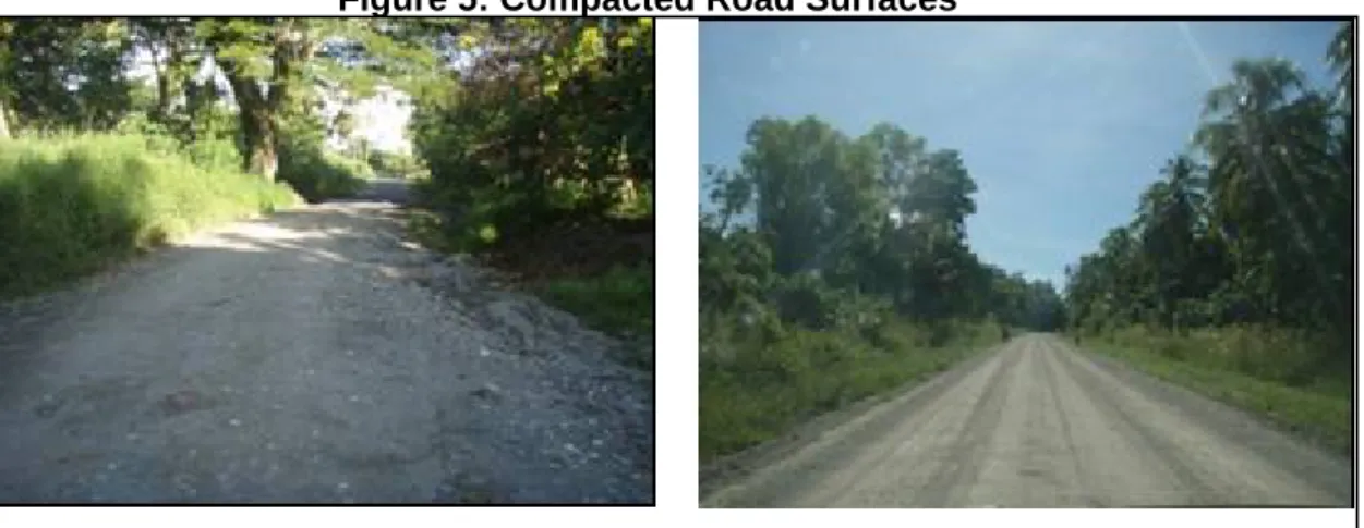
39. Coral materials that comply with the requirements in Table 4 can be used for base course and sub-base course pavement. The use of coral materials relies on good compaction to produce a dense interlocking structure. The achievement of a correct density is essential to minimise water seeping through to the road base. PNG Laboratory tests recommend compacted layer thickness should not exceed 150 mm. This can vary depending on results of in-situ testing. 40. Figure 5 shows a comparison of road surfaces with compacted river gravel and coral pavement material.
When selecting materials to be used, the following factors need to be considered: Material availability nearby
Suitability (quality) of the materials Cost of extracting and hauling Maintainability
Environmental aspects
Figure 5: Compacted Road Surfaces
5. Source of Aggregates
41. Apart from the river gravels sourced from the Lungga River, there are several aggregate mining companies in Honiara which hold building material permits from the government and can supply graded aggregates for road works. A list of the suppliers with details of company activities is attached in Attachment 4.
6. Drainage
42. Any road should have adequate drainage provision to: Maintain natural flow of water prior to reconstruction
Collect water from road surface to suitable discharge points Protect the road from overland flow from adjacent areas; and Provide appropriate level of service.
43. An effective design will balance a number of factors against cost. These factors include: Flooding effects on traffic delays and access difficulties
Possible structural damage due to severe storms and prolonged flooding Service life of drainage system and cost of replacement or improvement Road maintenance costs.
44. A detailed design for rehabilitating the existing road to a standard design cross section must consider the following issues:
Grading of the roadway with respect to flood levels, groundwater levels and tidal levels
Estimated runoff
Maximum permissible flow width of the carriageway Size of cross culverts and outlet conditions
Surface drainage
Weather changes and severe storms and greater average return intervals than the standard design value.
45. The existing drainage provision for the subproject is considered poor and mostly depends on natural surface flow. This is one of the major causes of road damage in locations where water is lodged within the road pavement due to poor or no drainage provision. The proposed rehabilitation work will include provision of trapezoidal earth (unlined) catch drains for the first 2.5 km of the road and other locations where natural surface flow is blocked by earth mounts or vegetations which are not removable. Cross-road drainage pipes will be considered for low spot locations where the road surface will require lifting to avoid accumulation of water on the road surface due to heavy rain periods.
46. A typical unlined catch drain to be used for this project is shown in Figure 6 below: Figure 6: Typical Design for Unlined Catch Drain
47. It does not appear that any major structural drainage culverts will be necessary on the subject road. Areas requiring drainage improvements have been identified during field observation including cross road RDC pipes, earth catch drains and masonry box drains recommended for minor access roads and driveways. For major access roads and cross road drainage, a minimum of 600 mm RCP with appropriate cover and end treatments is recommended.
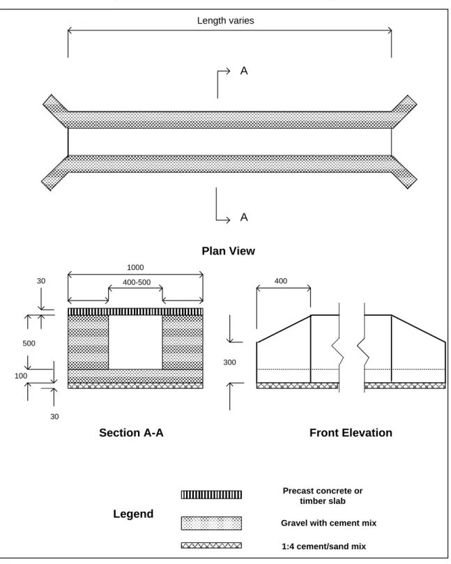
48. A typical design for a masonry box drain is shown in Figure 7.
49. Calculations have been done in order to arrive at preliminary cost estimates of the rehabilitation.
Figure 7: Typical Masonry Box Drain Design
A
A Length varies
Plan View
Section A-A Front Elevation
500 100 30 30 400 300 1000 400-500 1:4 cement/sand mix Gravel with cement mix
Precast concrete or timber slab
7. Preferred Cross Section
50. Current road cross section dimensions vary from road section to section. It is recommended that the standard cross section design shown in Figure 8 below be adopted and adjusted as necessary to suit local environmental constraints.
Figure 8: Standard Cross Section Design
C. Road Safety Considerations
51. With the existing low volume and poor pavement surface, current operating vehicle speeds do not exceed the design speed of 50 km/h. No consideration has been made to improve the road safety aspect in rural road design requirements.
52. However, the subject road is capable of operating speed higher than the design speed and when the road is rehabilitated; operating speeds will increase with increasing risks of potential accidents. Field observations revealed the following possible attributes to accident risks:
Sub-standard horizontal curves with below minimum sight distances Narrow pavement widths
Lack of road edge definition Lack of pedestrian footpaths Overloading of vehicles
Erosion of road edges due to flooding and/or severe storms
53. For a very low cost proportion of the total rehabilitation cost of the project, some warning devices such as guide posts and curve warning signs should be provided as part of the implementation requirement.
D. Implementation Strategy and Project Risks
53. The development of any transport infrastructure must include a strategy for the future land use and economic development and needs of hinterland population for access to transport services.
54. The network connectivity is the prime consideration for transport network planning. This has been emphasized by Australian Agency for International Development in the Australia-Solomon Islands Partnership Development in the Implementation Strategy for transport infrastructures and is consistent with ADB project preparation approach and the Solomon Islands’ National Transport Plan policy.
55. Maximizing connectivity across multi-modal links would increase effectiveness of development partner assistance to improve access to services and income earning opportunities. The whole transport network will therefore focus on sustainability, thus maintenance and rehabilitation will have priority rather than new construction.
56. It is MID’s policy (which is consistent with the policies of the development partners) to encourage labour based methods for routine maintenance and rehabilitation works, supported by use of machines where required. The Hifab report (2010) considered labor-based, equipment-supported (LBES) methodology in all road works in the Solomon Islands, including routine and periodic maintenance, rehabilitation and upgrading, covering different classes of roads, and proposed the methodology matrix as shown in Table 5 below.
Table 5: Proposed LBES Methodology Matrix
Road / Pavement Category Rehabilitation and Spot Improvement Routine Maintenance Periodic Maintenance Upgrading and reconstruction
1 Unsealed access LBES LBES NA Equipment
2 Unsealed Feeder LBES LBES NA Equipment
3 Coral stone – low traffic
LBES +
Equipment LBES Equipment Equipment 4 Coral stone – medium
traffic
LBES + Equipment
LBES +
Equipment Equipment Equipment 5 Gravel – low traffic LBES +
Equipment LBES Equipment Equipment 6 Gravel – medium
traffic
LBES + Equipment
LBES +
Equipment Equipment Equipment 7 Sealed road – low –
medium-traffic
LBES +
Equipment LBES Equipment NA
8 Sealed road –
medium-high traffic Equipment
LBES +
Equipment Equipment NA
Source: “Review of Labour-Based Road Maintenance and Contracting Activities in Solomon Islands” Hifab International AB March 2010.
57. This subproject falls into Road/Pavement category 5 (gravel road with low traffic volumes), which can therefore be implemented using a labour based equipment supported method for rehabilitation works and labour based approach for routine maintenance and equipment bases approach for periodic maintenance.
58. This subproject consists of rehabilitation of the existing road surface to a condition which will be sustainable, with ensuing routine and periodic maintenance. The main rehabilitation task consists of reshaping and gravelling most sections of the road using river gravels hauled from Lungga River. An agreement between MID and the community will be required to ensure the supply of gravel material and local labour required.
59. Main project risks and their mitigation measures are identified as follows:
(i) Lack of suitably experienced contractors who could confidently carry out the tasks, which include the use of local labours – can be mitigated by contractor training.
(ii) Reliability of equipment and reluctance to invest in equipment and machinery due to uncertainty of continuation of work – can be mitigated through the Solomon Islands Government ensuring a continuous financing and program of road maintenance and rehabilitation works.
(iii) Construction supervision capability of MID – can be mitigated by external contract management support to MID (in the form of a Central Project Implementation Unit: CPIU), and MID’s capacity building.
(iv) Delay in implementation may cause further damage to the road pavement to an extent that may require complete reconstruction, thus reducing the project viability due to increase in project costs – can be mitigated through effective contract management supported by CPIU consultants.
(v) A suitable future maintenance strategy is required to sustain access service level – can be mitigated by creating appropriate road asset management procedures and defining maintenance service level requirements.
E. Rehabilitation Costs
60. The rehabilitation cost estimates of the subproject have been produced based on unit cost rates taken from previous similar projects. The final unit costs will be a result of the detailed design, the competitive bidding process and the implementation stage. A number of factors will contribute to the final costs such as:
Change of horizontal and vertical alignment at the detail design stage.
Use of different materials other than recommended for the preliminary concept. Change in drainage provision in the detailed design stage.
Under estimate of labour capacity in undertaking the recommended tasks. Road furniture such as signage has not been included.
Competition amongst the contracting industry at the time of tendering the contract 61. The cost estimates have been produced for the purpose of economic assessment. 62. Table 6 summarises the rehabilitation costs. Detailed cost calculations are shown in Attachment 2.
Table 6: Summary of St Martin Road Rehabilitation Costs
DESCRIPTION SI$
Local Foreign Total
1. Mobilisation, clearing and site
establishment 190,000 60,000 250,000
2. Vegetation clearing 66,200 0 66,200
3. Pavement works 1,068,350 313,000 1,381,350
4. Drainage works 530,700 142,500 673,200
5. Day Works (labour) 420,100 0 420,100
6. Day Works (machine and plant) 396,000 160,000 556,000
Sub-total 2,671,350 675,500 3,346,850
Contingencies (15%) 502,028
Total 3,848,878
$ 486,621 Exchange rate $1.00 = SI$ 7.9094 (as of 1 October 2010).
F. Maintenance Costs
1. Routine Maintenance
63. Maintenance contract can be either attached to the subproject rehabilitation contract for a certain period of time, or maintenance can be contracted separately. The annual routine maintenance cost is estimated to be approximately SI$ 50,500 and will mainly involve labour- based works. The estimated cost is based on the tasks and frequencies proposed as shown in Table 7 below.
Table 7: Labor-Based Routine Maintenance Schedule
Activity Item
Work description Frequency
(No/year)
Season
1 Inspection and removal of litter and other
road obstructions and debis 4
Before rainy season During wet weather At end of wet season During dry season
2 De-silting of Culverts and clearing inlets
and outlets 3
Before rainy season At end of wet season During dry season
3 Clear side and mitre drains 4
Before rainy season During wet weather At end of wet season During dry season 4 Repair Erosion of shoulders and Drains NA
5 Repair Scour checks NA
6 Grub roadway (consider for machine
based) 1
At end of wet season During dry season 7 Clear structures and waterways NA
8 Fill potholes and ruts on carriageway 2 At end of wet season During dry season 9 Cut grass and vegetable trimming and
removal 3
At end of wet season During dry season
64. Table 8 below sumarises the cost estimates for the recommended labor based routine maintenance contract.
Table 8: Labor Based Routine Maintenance Cost Estimate for St. Martin Road
Work Item Unit
A B C D E
Quantity Output per workday (wd) Number of workdays = A/B Daily Rate SI$ Total Cost = CxD SI$
1 Inspection and removal of litter and other road
obstructions and debis
Km 8.5x4 0.5km 68 40 2,720
2 De-silting of Culverts and
clearing inlets and outlets no 153x3 15m 31 40 1,240 3 Clear side and mitre
drains m 240x4 20m 48 40 1,920
4 Repair Erosion of
shoulders and Drains NA 5 Repair Scour checks NA
6 Grub and reshape
roadway m
2
600x2* 5m2 240 40 9,600
7 Clear structures and
waterways NA 8 Repair potholes on carriageway m 2 600x2* 5m2 240 40 9,600 9 Repair ruts on carriageway m 600x2* 50m 24 40 960
10 Cut grass and vegetable trimming and removal m
2
22,500x2 200m2 225 40 10,200
*Estimated
Total Direct Labour Cost 36,240
Contingency 20% 7,248
Overhead 30% 10,872
Total Estimated Cost/year 54,360
Say 55,000
in $ 6,954 Note: Exchange rate $1.00 = SI$ 7.9094 (as of 1 October 2010).
2. Periodic Maintenance
65. It is envisaged that every five years (year 5, 15, etc.) the road pavement will receive periodic maintenance on the carriageway and spot resheeting (heavy grading with addition of wearing course material where it will be needed) and every ten years (year 10, 20 etc.) the periodic maintenance is expected to involve more massive resheeting and restoration of the drains to their original shape. The ‘lighter’ periodic maintenance activity is estimated to cost about SI$ 50,000 per km and the ‘heavier’ about SI$ 120,000 per km.
66. Using the cost estimates given, and assuming half of the routine maintenance costs on a year of periodic maintenance, the annualised maintenance costs (including both routine and periodic maintenance; in 2010 costs, not discounted) over the period of 20 years can be estimated at SI$ 22,820 per km, or $ 2,885 per km.
ATTACHMENT 1
ATTACHMENT 2
Cost
Estimates
for
Rehabilitation
of
St
Martin
Road
Item Description Unit Quantity Rate SI$ Amount SI$ Amount $
A General
1 Mobilisation to site including transporting
equipment and establishment of work site and
workers camp etc LS 1 100,000 100,000
2 Demobilisation from site LS 1 100,000 100,000
3 Other overhead LS 1 50,000 50,000
Sub‐total A 250,000 31,608
B Cleaning and Scrubbing
2.1 Vegetation Cutting and grubbing(LB) m2 25,500 2 51,000
2.2 Remove cuttings litter and debris to dump(LB) m3 1,900 8 15,200
Sub‐total B 66,200 8,370
C Rehab Pavements
3.1 Rip‐up, mix, reshape and re‐compact m2 46,750 15 701,250
3.2 Dispose off unsuitable m3 2,400 15 36,000
3.3 Place extra gravel to fill pot holes and raise pavements
to designed levels, scarify, reshape with water
and re‐compacted pavement to 95% MDD. m3 3,390 190 644,100
Sub‐total C 1,381,350 174,647
D Drainage Provision
4.1 Excavate materials and remove high shoulders (LB) m3 19,780 15 296,700
4.2 Shape and provide earth drains (LB) m 15,000 8 120,000
4.3 Install masonry drains for driveways (LB) m 75 600 45,000
4.4 Install 900RCP cross culverts with end treatments m 175 900 157,500
4.5 Install 600RCP side culverts with end treatments m 30 1,800 54,000
Sub‐total D 673,200 85,114 E Day Works 5.2 Supervisor Month 6 17,000 102,000 5.3 Surveyor Month 1 25,000 25,000 5.4 Foreman Month 6 15,000 90,000
5.5 Plant Operators Day 180 360 64,800
5.6 Tradesman Day 30 300 9,000
5.7 Mechanic Day 30 450 13,500
5.8 Truck Driver Day 60 250 15,000
5.9 Security Guard Day 180 100 18,000
5.10 Skilled Laborer Day 240 120 28,800
5.11 Unskilled Laborer Day 540 100 54,000
Sub‐total E 420,100 53,114
F Machine and Plant
6.1 Concrete Mixer 0.3m3 Day1 20 500
10,000
6.2 Bull dozer ‐ NA
‐
6.3 Grader CAT14H Day1 30 5,000
150,000 6.4 Loader 1.4 m3 Day1 30 3,000 90,000 6.5 Backhoe 12T Day 30 3,000 90,000
6.6 Tipper Truck 8 m3 Day1 30 2,500
75,000
6.7 Water Cart Day 30 1,500
45,000
6.8 Vibrating Roller Day 20 4,800
96,000
1
The unit costs for these item were derived from 2008 Basic
Cost Data for Solomon islands adjusted for inflation (SIRIP)
Sub‐total F 556,000 70,296 Total A+B+C+D+E+F 3,346,850 423,148 Contingencies (15%) 502,028 63,472
Total estimated cost 3,848,878 486,621
Conversion Rate: $ 1 = SI$ 7.9094
ATTACHMENT 3
Example of Cross Section and Drain Design
Standard Culvert Details 2
St. Martin Road Design Plan Ch 700-Ch1500
St. Martin Road Design Plan Ch 2300-Ch3000
47