This version is available at https://doi.org/10.14279/depositonce-9347
© 2019 IEEE. Personal use of this material is permitted. Permission from IEEE must be obtained for all other uses, in any current or future media, including reprinting/republishing this material for advertising or promotional purposes, creating new collective works, for resale or redistribution to servers or lists, or reuse of any copyrighted component of this work in other works.
Terms of Use
Sumbul, Gencer; Demir, Begüm (2019). A Novel Multi-Attention Driven System for Multi-Label Remote Sensing Image Classification. In: IGARSS 2019 - 2019 IEEE International Geoscience and Remote Sensing Symposium. pp. 5726–5729.
https://doi.org/10.1109/IGARSS.2019.8898188
Gencer Sumbul, Begüm Demir
A Novel Multi-Attention Driven System for
Multi-Label Remote Sensing Image
Classification
Accepted manuscript (Postprint) Conference paper |
A NOVEL MULTI-ATTENTION DRIVEN SYSTEM FOR MULTI-LABEL REMOTE SENSING
IMAGE CLASSIFICATION
Gencer Sumbul and Beg¨um Demir
Faculty of Electrical Engineering and Computer Science, Technische Universit¨at Berlin, Germany
ABSTRACT
This paper presents a novel multi-attention driven system that jointly exploits Convolutional Neural Network (CNN) and Re-current Neural Network (RNN) in the context of multi-label re-mote sensing (RS) image classification. The proposed system consists of four main modules. The first module aims to ex-tract preliminary local descriptors of RS image bands that can be associated to different spatial resolutions. To this end, we introduce a K-Branch CNN, in which each branch extracts de-scriptors of image bands that have the same spatial resolution. The second module aims to model spatial relationship among local descriptors. This is achieved by a bidirectional RNN ar-chitecture, in which Long Short-Term Memory nodes enrich local descriptors by considering spatial relationships of local areas (image patches). The third module aims to define multi-ple attention scores for local descriptors. This is achieved by a novel patch-based multi-attention mechanism that takes into account the joint occurrence of multiple land-cover classes and provides the attention-based local descriptors. The last module exploits these descriptors for multi-label RS image classification. Experimental results obtained on the BigEarth-Net that is a large-scale Sentinel-2 benchmark archive show the effectiveness of the proposed method compared to a state of the art method.
Index Terms— Multi-label image classification, deep neu-ral network, attention mechanism, remote sensing
1. INTRODUCTION
The increased number of recent Earth observation satellite mis-sions has led to a significant growth of remote sensing (RS) im-age archives. Accordingly, classification of RS imim-age scenes, which is usually achieved by direct supervised classification of each image in the archive, has received increasing attention in RS [1, 2]. Most of the supervised classifiers developed for RS image scene classification problems are trained on images annotated with single high-level category labels, which are associated to the most significant content of the image. How-ever, each RS image typically consists of multiple classes and thus can be simultaneously associated to different low-level land-cover class labels (i.e., multi-labels) [1]. Thus, supervised classification methods that exploit training images annotated by multi-labels have been recently introduced in RS. As an
ex-ample, a sparse reconstruction-based RS image classification and retrieval method is introduced in [1]. This method consid-ers a measure of label likelihood in the framework of sparse reconstruction-based classifiers and generalizes the original sparse classifier to the case of multi-label RS image classifica-tion and retrieval problems. Recent advances in deep learning have attracted great attention in RS image classification prob-lems. In [3], a Recurrent Neural Network (RNN) architecture that sequentially models the co-occurrence relationships of land-cover classes with class-specific attention extracted from a Convolutional Neural Network (CNN) is introduced in the framework of multi-label image scene classification. In this method, inaccurate prediction of any land-cover class label can be propagated through the RNN sequence and this may af-fect the accurate prediction of other classes in the same image. This issue is known as error propagation problem [4]. To ad-dress this problem, we propose a system that includes a novel patch-based multi-attention mechanism. The proposed mecha-nism allows accurate characterization of the joint occurrence of different land-cover classes and thus reduces the effect of the error propagation problem.
2. PROPOSED MULTI-ATTENTION DRIVEN SYSTEM
LetX={x1, ...,xM}be an archive that consists ofMimages, wherexiis theithimage. We assume that each image in
X is associated with multi-labels from a label setL={l1, ..., lC} with|L| = C. Label information ofxi is defined by a bi-nary vectoryi∈ {0,1}C, where each element ofyiindicates the presence or absence of labellc ∈ Lin a sequence. We assume that for a given imagexi, the spectral bands can be associated to theKdifferent spatial resolutions, resulting in different pixel sizes. We aim to learnF(x∗) =g(f(x∗))that
maps a new imagex∗ to multi-labels, wheref(·)generates
classification scores for each label ofLandg(·)producesy∗
as a predicted label set. The proposed system is character-ized by four main modules: 1) extraction of local descriptors by a K-Branch CNN; 2) characterization of spatial relation-ships among local areas (image patches) with an LSTM based bidirectional RNN; 3) defining multiple attention scores for local descriptors by a novel patch-based multi-attention mech-anism; and 4) multi-label scene classification. Fig. 1 presents the block diagram of the proposed system and each module is
X=
Extract Non-overlapping
Local Areas
{xi}Mi=1
Group Bands for Each Spatial Resolution Obtain Local Descriptors by K-Branch CNN ρr i,k Update Local Descriptors by Bidirectional RNN ψi,r Obtain Multiple Attention Scores by Multi-Attention Mechnasim Ωi Define Final Set of Local Descriptors Ai Ωi Classify Images Ψi
Fig. 1: Block diagram of the proposed system with a novel patch-based multi-attention mechanism.
explained in the following sections.
2.1. Extraction of Local Descriptors by the Proposed K-Branch CNN
This module aims to extract local descriptors of each image in the archive. We assume that each image band can be associated to different spatial resolutions (e.g., Sentinel-2 image bands). To this end, we introduce K-Branch CNN to use different CNNs specialized for RS image bands with different spatial resolutions. We would like to note that if all bands are asso-ciated with the same spatial resolution, this module becomes a single branch CNN (i.e.,K = 1). We initially divide each image toRnon-overlapping local areas (i.e., patches) and then define different sets of bands based on their spatial resolution. Letρr
i,kbe thekthsubset of therthpatch with a given spatial resolution, wherek∈ {1,2, ..., K}andr∈ {1,2, ..., R}. Let φkbe thekthbranch that generates a descriptor forρr
i,kby ap-plying convolutional layers and one fully connected (FC) layer. After obtaining different local descriptors for all subsets, they are concatenated into one vector for one patch. Then, a new FC layer takes all concatenated vectors and produces the local descriptorsψi,r. Our K-Branch CNN module is illustrated in Fig. 2.
2.2. Characterization of Spatial Relationship among Im-age Patches
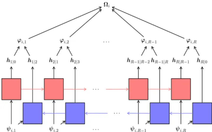
This module aims to: i) model the spatial relationships of im-age patches; and ii) update the local descriptors based on this information. To this end, we utilize two RNNs in a bidirec-tional manner. Each node of the first RNN updates the descrip-tor of one patch concerning previous patches (i.e., previous nodes). The second RNN employs the same idea by consider-ing the subsequent patches. For the nodes of each RNN, we use the LSTM [5] neurons because of their capacity to cap-ture long-term dependencies among nodes. Thus, each LSTM node takes the descriptor of therthpatch (ψ
i,r) from the K-Branch CNN as input and updates this descriptor concerning the successive local descriptors as follows:
fr=δ(Wf,rψi,r+Uf,rhτ+bf,r)
ir=δ(Wi,rψi,r+Ui,rhτ+bi,r)
or=δ(Wo,rψi,r+Uo,rhτ+bo,r)
cr=frcτ+irtanh(Wc,rψi,r+Uc,rhτ+bc,r)
hr=hr|τ=ortanh(cr)
(1)
Fig. 2: The proposed K-Branch CNN to obtain local descriptors.
h1|0 h1|2 ϕi,1 ψi,1 h2|1 h2|3 ϕi,2 ψi,2 . . . . . . . . . . . . hR−1|R−2hR−1|R ϕi,R−1 ψi,R−1 hR|R−1 hR|0 ϕi,R ψi,R Ωi
Fig. 3: The proposed bidirectional RNN module. Forward and back-ward passes are shown in red and blue, respectively.
wheretanhis the hyperbolic tangent function,δis the sigmoid function,W.,randb.,rare the weight and bias parameters.i, f,o andcare input gate, forget gate, output gate and cell state, respectively (for a detailed explanation, see [6]). For bidirectional RNN architecture, we use two LSTM nodes (for forward and backward passes) related to each image patch with different parameters. For the first and second time order,
τbecomesr−1andr+1, respectively since two RNNs update local descriptors in the reversed order. For the beginning of passes (r= 1orr=R),τrefers to an initial state of the nodes. Thus, we obtain the sequentially updatedrthlocal descriptor
ofxiby concatenating the outputs of the two LSTM nodes as follows:
ϕi,r = [h>r|r−1,h>r|r+1]>. (2) Our bidirectional RNN module is illustrated in Fig. 3.
2.3. Defining Multiple Attention Scores for Image Patches by a Novel Multi-Attention Mechanism
Each local descriptor can be associated with multiple land-cover classes. This module aims to determine the attention scores for each local descriptor. Attention scores show the rel-evancy of considered image patch in terms of the land-cover classes present in the whole image for the complete charac-terization of its semantic content. To this end, we introduce a novel multi-attention mechanism to obtain multiple attention
non-irrigated arable land, pastures, land principally occupied by agriculture, inland marshes, water courses
non-irrigated arable land, vineyards, pastures, land principally occupied by agriculture
coniferous forest, water bodies
non-irrigated arable land, land principally occupied by agriculture, coniferous forest, mixed forest, water bodies
olive groves, land principally occupied by agriculture, broad-leaved forest, transitional woodland/shrub, water bodies
non-irrigated arable land, pastures, complex cultivation patterns
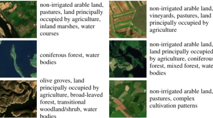
Fig. 4: Example of Sentinel-2 images and their multi-labels in the BigEarthNet archive.
scores as follows:
Ai=σ(Wa,2tanh(Wa,1Ωi)) (3) whereΩidenotes a matrix, whose columns contain local de-scriptors.Wa,1 andWa,2 are the weight parameters of the attention mechanism andσis the softmax function that pro-duces normalized weights within the interval[0,1]. This at-tention mechanism can be regarded as two FC layers that use hyperbolic tangent and softmax activation functions without bias parameters. Therefore, attention matrixAi ∈[0,1]T×R providesTdifferent attention scores for each patch. Then, the final setΨiof descriptors forxican be obtained by: i) mul-tiplication ofΩiwith the attention matrix; and ii) addition of non-linearity withmaxfunction to useΨifor the multi-label classification module. Attending to each patch with multiple scores allows us to consider the joint occurrence of all land-cover classes in the label sequence. For instance, an increase in one of the attention scores of a local descriptor forbeachclass will increase the attention score of the same local descriptor for theseaclass while it may not be the case for other local descriptors.
It is worth noting that a single attention score could be used for this module. However, since multi-label image clas-sification problem requires to jointly learn multiple classes, the use of single attention score is not sufficient and multiple attention scores are necessary.
2.4. Classification of RS Image Scenes with Multi-Labels
This module aims to assign multi-labels to RS images by us-ing the final setΨiof descriptors. To this end, a classification layerf(·)that generates class scoreszlj for each class label
ljin a sequence by using the vectorizedΨiis considered. Fi-nally, we obtain the class posterior probability ofljfor the im-agexiwith thesigmoidfunction as:P(lj|xi) =1/(1+e−zlj).
After end-to-end training of the whole neural network by min-imizing cross-entropy loss, the proposed system predicts the multi-labels of a new imagex∗by thresholding the probability
values.
We would like to note that unlike [3], our system predicts multi-labels of an RS image by considering all outputs of an
RNN instead of deciding each label by considering a single class specific node.
3. EXPERIMENTAL RESULTS
Experiments were conducted on the BigEarthNet benchmark archive1that was constructed by selecting 125 Sentinel-2 tiles
distributed over 10 European countries (Austria, Belgium, Fin-land, IreFin-land, Kosovo, Lithuania, Luxembourg, Portugal, Ser-bia, Switzerland) and acquired between June 2017 and May 2018 [7]. In details, all the considered image tiles are asso-ciated with cloud cover percentage less than 1% and were atmospherically corrected by the Sentinel-2 Level 2A product generation and formatting tool (sen2cor). All spectral bands except the 10thband, for which surface information is not
em-bodied, were included. The tiles were divided into590,326
non-overlapping images. Each image in the archive is a sec-tion of: i)120×120pixels for 10m bands; ii)60×60pixels for 20m bands; and iii)20×20pixels for 60m bands. Each image in the archive has been annotated with one or more land-cover class labels (i.e., multi-labels) provided from the CORINE Land Cover (CLC) database of the year 2018 (CLC 2018). We included Level-3 CLC classes except glaciers and perpetual snow class (and thus43land-cover classes are included). The number of labels associated to each image varies between1
and12, whereas95%of images have at most5multi-labels. Fig. 4 shows an example of images and the multi-labels as-sociated with them. The BigEarthNet will make a significant advancement in terms of developments of algorithms for the analysis of large-scale RS image archives.
In the experiments,70,987images that are fully covered by seasonal snow, cloud and cloud shadow were eliminated2.
Then, among the remaining images, we randomly selected: i)
60%of images to derive a training set; ii)20%of images to derive a validation set; and iii) 20% of images to derive a test set. Then, we divided each image into16non-overlapping patches. Since Sentinel-2 image bands are associated to three different spatial resolutions, we selectedK = 3for the K-Branch CNN. Thus, we split the bands into three subsets for each patch and in each subset we stacked bands into a single volume for its corresponding CNN branch. The first branch takes as input the bands2to4and8(which have10m spatial resolution), while the second branch takes as input the bands
5to7,8A,11and12(which have20m spatial resolution) and the third branch takes as input the bands1and9(which have
60m spatial resolution). Selection of the number of patches and all other hyperparameters was achieved based on the clas-sification performance on the validation set. All branches have the same regime for the number of filters of convolutional lay-ers. We used32filters for the initial layers. While adding new layers, the number of filters is first increased to the multipli-cation of2and then decreased to the division of 2. It ends
1The BigEarthNet is available athttp://bigearth.net.
2The lists of images fully covered by seasonal snow, cloud and cloud
Table 1: Results obtained by the CA-ConvBiLSTM and our system.
Method R(%) F1 F2
CA-ConvBiLSTM [3] 77.56 0.7089 0.7405
Proposed System 80.0 0.7289 0.7631
with64filters for all branches. However, filter size and ap-plied operations between convolutional layers of each branch are different.5×5filters for initial layers and3×3filters for deeper layers are used for the first branch. For the second and third branches,3×3filters and2×2filters are used through-out the layers, respectively. For all convolutional layers, stride of 1 and zero padding were used. In addition, we applied max-pooling for the first two branches. However, in order not to decrease spatial resolution more, it was not applied to the last branch. For each branch, an FC layer, which takes the output of the last convolutional layer and produces spatial resolution specific description of an image portion, was considered. For the bidirectional RNN module, we exploited the LSTM nodes with128-dimensional hidden units.
In the experiments, we compared our system with the CA-ConvBiLSTM [3], which is the only multi-label RS image classification method that considers deep learning. For a fair comparison, we used our first branch as the feature extrac-tion module of the CA-ConvBiLSTM. We applied cubic in-terpolation to20m and60m bands in order to stack all bands into one volume, which was fed into the first branch. For the RNN part of the CA-ConvBiLSTM, we used the same type of LSTM nodes as in our system. We applied the same end-to-end training procedure from scratch for all experiments to compare both methods under the same setting. All model pa-rameters were initialized with Xavier method [8] except the suggested LSTM initialization of the CA-ConvBiLSTM. We trained models100 epochs with the initial learning rate of
10−3. Results of each method are provided in terms of three performance evaluation metrics: 1) Recall (R), 2)F1 Score and 3)F2 Score [9]. As we can see from Table 1, our sys-tem provides2.44%higher recall,0.02higherF1score and
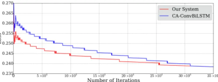
0.0226higherF2 score compared to the CA-ConvBiLSTM. The performance improvements on all metrics are statistically significant under a value ofp0.0001. In terms of training efficiency, our system achieves the lowest training loss earlier than the CA-ConvBiLSTM (see Fig. 5). This is very impor-tant for large-scale benchmark archives like BigEarthNet. We would like to note that the promising performance of our sys-tem compared to the CA-ConvBiLSTM relies on the efficient characterization of: i) local descriptors of image bands with different spatial resolutions; and ii) multiple attention scores for each local descriptor that evaluate the joint occurrence of multiple land-cover classes.
4. CONCLUSION
This paper proposes a novel multi-attention driven system for classification of RS images with multi-labels. The proposed system consists of four main modules: 1) the spatial resolution
Fig. 5: Training trajectory of the loss for our system and the CA-ConvBiLSTM. To display better, we used moving averages.
specific K-Branch CNN for the extraction of local descriptors; 2) the bidirectional RNN architecture with LSTM nodes for modeling the spatial relationships of the image patches; 3) the patch-based multi-attention mechanism to obtain multiple attention scores for each local descriptor; and 4) multi-label classification of images in the archive. Experimental results obtained on the BigEarthNet archive show the effectiveness of our system. As a future work, we plan to extract and ex-ploit image regions defined by segmentation algorithms for the characterization of local descriptors.
5. ACKNOWLEDGEMENTS
This work was supported by the European Research Council under the ERC Starting Grant BigEarth-759764.
6. REFERENCES
[1] O. E. Dai, B. Demir, B. Sankur, and L. Bruzzone, “A novel system for content-based retrieval of single and multi-label high-dimensional remote sensing images,” IEEE J. Sel. Top. Appl. Earth Obs. Remote Sens., vol. 11, no. 7, pp. 2473–2490, July 2018.
[2] G. Cheng, J. Han, and X. Lu, “Remote sensing image scene classification: Benchmark and state of the art,”Proc. IEEE, vol. 105, no. 10, pp. 1865–1883, October 2017.
[3] Y. Hua, L. Mou, and X. X. Zhu, “Recurrently exploring class-wise attention in a hybrid convolutional and bidirectional lstm network for multi-label aerial image classification,” arXiv preprint arXiv:1807.11245, 2017.
[4] R. Senge, J. J. del Coz, and E. H¨ullermeier, “On the problem of error propagation in classifier chains for multi-label classifi-cation,” inData Analysis, Machine Learning and Knowledge Discovery, pp. 163–170. 2014.
[5] S. Hochreiter and J. Schmidhuber, “Long short-term memory,”
Neural Comput., vol. 9, no. 8, pp. 1735–1780, November 1997. [6] F. A. Gers, J. Schmidhuber, and F. Cummins, “Learning to forget:
Continual prediction with LSTM,”Neural Comput., vol. 12, no. 10, pp. 2451–2471, 2000.
[7] G. Sumbul, M. Charfuelan, B. Demir, and V. Markl, “BigEarth-Net: A large-scale benchmark archive for remote sensing image understanding,” inIEEE Intl. Geosci. Remote Sens. Symp., 2019. [8] X. Glorot and Y. Bengio, “Understanding the difficulty of train-ing deep feedforward neural networks,” inIntl. Conf. Artificial Intelligence and Statistics, 2010, pp. 249–256.
[9] M. Zhang and Z. Zhou, “A review on multi-label learning al-gorithms,” IEEE Trans. Knowl. Data Eng., vol. 26, no. 8, pp. 1819–1837, August 2014.