ISSN Online: 1947-394X ISSN Print: 1947-3931
DOI: 10.4236/eng.2019.119041 Sep. 17, 2019 592 Engineering
Study on the Layout of 15-Minute
Community-Life Circle in Third-Tier Cities
Based on POI: Baoding City of Hebei Province
Zeqin Li, Jie Zheng, Yukun Zhang
School of Architecture, Tianjin University, Tianjin, China
Abstract
At present, the planning of 15-minute community-life circle is being actively promoted in China. Taking Baoding City as an example, the status quo of service facilities layout was analyzed based on the POI data. Using the spatial accessibility algorithm, the ranges of 15-minute life circle of more than 1000 communities in Baoding were determined. By calculating the up-to-standard rates of public service facilities in each district, it is found that the allocation of medical facilities and commercial facilities in urban community life circle is relatively perfect, but the allocation of public cultural facilities and pension facilities is obviously inadequate. Based on this, optimization suggestions on the layout of public service facilities in the 15-minute life circle were put for-ward from three aspects: facilities sharing, function mixing and population structure and activity characteristics differentiation. It not only provides data and technical support for the planning and construction of community life circle in Baoding city, but also provides referable examples and promotable models for the community planning of third-tier cities.
Keywords
Community Life Circle, Accessibility, Up-to-Standard Rate, Planning Strategy
1. Introduction
In recent years, the concept of “15-minute life circle” has been widely recognized and promoted in China, and gradually applied to urban planning. In 2016, the Shanghai Master Plan put forward the idea of “15-minute community life circle” as the basic unit of building community life, providing basic service functions How to cite this paper: Li, Z.Q., Zheng, J.
and Zhang, Y.K. (2019) Study on the Layout of 15-Minute Community-Life Circle in Third-Tier Cities Based on POI: Baoding City of Hebei Province. Engineering, 11, 592-603.
https://doi.org/10.4236/eng.2019.119041
Received: August 20, 2019 Accepted: September 14, 2019 Published: September 17, 2019
Copyright © 2019 by author(s) and Scientific Research Publishing Inc. This work is licensed under the Creative Commons Attribution International License (CC BY 4.0).
DOI: 10.4236/eng.2019.119041 593 Engineering and public activity space for residents within walking distance, aiming to form a safe, friendly and comfortable community living platform [1]. The newly promulgated Standard for Urban Residential Area Planning and Design (GB 50180-2018) in 2018 clearly defines the meaning of “15-min pedestrian-scale neighborhood”. According to the principle of the basic living needs of residents, facilities are allocated within the reasonable distance of 15-minute walking. In this context, it is imperative to implement the planning of urban “15-minute life circle”. Because of the large number of third and fourth-tier cities and the large population of those cities, and the relatively outdated infrastructure, those cities are the focus of urban development planning. Taking Baoding City as an exam-ple, this paper explores the life circle planning which is still in its infancy.
The research and planning of life circle began in Japan in the 1960s. In 1969, the Ministry of Construction and the Ministry of Land Affairs of Japan put for-ward the concepts of “local life circle” and “settled circle”. Settlement circle was dominated by people’s demand for activities. According to residents’ daily life needs such as employment, schooling, shopping, medical treatment, education and entertainment, area coverage for planning a day’s life was defined as a spa-tial planning unit. Later, this concept was gradually accepted in Asia. South Ko-rea’s residential planning was affected by it, and the allocation of community service facilities was organized with the construction of different levels of life circles. In the comprehensive development plan of 1979, Taiwan also adopted the concept of “local life circle” to classify cities and promote balanced regional development [2].
DOI: 10.4236/eng.2019.119041 594 Engineering the main body of China’s development and the “short slab” of modern city con-struction. Therefore, this paper focuses on the allocation of public service facili-ties in the third-tier urban life circle, and combines with relevant research to ex-plore the optimal strategies for the allocation of public service facilities in the third-tier cities, taking Baoding City, Hebei Province as an example.
At present, there are two main methods to measure life circle: one is based on survey of residents’ daily activities. For example, Sun Daosheng et al. [8] have spatially divided the community life circles by collecting GPS activity trajectories of individual residents in 18 communities. Although this method pays attention to the real behavior information of residents, it may be affected by the behavior habits of some residents, which leads to the deviation of the survey results. The second is to use the analysis method of the buffer. For example, Zhao Yanyun et al.[5] take the entrance of the community as the starting point and 1 km as the radius (15 minutes walking distance), the buffer zone is constructed as the scope of community life circle and the spatial distribution of public service facilities in the community is calculated. However, this method does not take into account the real road network situation, so that the results are not accurate enough. In this study, the existing methods are synthetically used for reference, and the GIS software platform is used to construct the traffic network data set to calculate the real walking path of residents. This method breaks through the limitation of buffer calculation with a certain distance, and also makes the results more au-thentic.
2. Data Acquisition
The data collected by the research institute mainly include the datasets of ad-ministrative regions, POI data of public service facilities, road data at all levels, and related data of residential districts in downtown Baoding. The data types and sources are shown in Table 1.
Among them, the POI of public service facilities (Point of Interest, refers to the point containing the information of the name, category, geographical loca-tion of facilities) is crawled on the Amap using Python tool, and the time node is June 2019. Referring to the Standards for Planning and Design of Urban Resi-dential Areas (GB 50180-2018) and the daily needs of community residents, these data can be divided into six categories: convenient commercial facilities, educational facilities, medical facilities, recreational and sports facilities, dining facilities and pension facilities, shown in Table 2. After data acquisition, cleaning (eliminating invalid information such as errors and duplication) and coordinate
Table 1. Data resources.
Data Content Data Resource Data Content Data Resource
Administrative region Shuijingzhu Map POI data of public service facilities Amap
DOI: 10.4236/eng.2019.119041 595 Engineering Table 2. Categories of facilities.
Category Specific Facilities Quantity
Convenient commercial facility Convenience store, super market, vegetable market, greengrocery 2898
Dining facility Chinese restaurant, fast-food restaurant, casual restaurant 11871
Educational facility Kindergarten, primary school, high school 438 Medical facility Drugstore, clinic, general hospital 1542
Recreational and sports facility Public recreational building, sports building, community cultural center 530
Pension facility Nursing home, recreation center for the aged 102
rectification (because the original data coordinate system is Mars coordinate system, coordinate rectification needs to be converted to WGS84 coordinate system), it is imported into GIS for research, shown in Figure 1.
3. Research Methods
1) Kernel Density AnalysisKernel density analysis is used to calculate the density of elements in their surrounding fields. It can be expressed as
( )
1 1 n i d i x x
f x K
h nh = − =
∑
. K(x) is the kernel function, h is the path distance attenuation threshold, i.e. bandwidth, n is the sample points in the bandwidth range, d is the dimension of the data (d = 2 when calculating two-dimensional data), (x − xi) represents the distance fromthe estimated point to the sample point xi. In the kernel density analysis, the
weight of the points in the search area is in reverse proportion to the distance from the grid search center, that is, the closer to the grid search center, the greater the weight of the points. The kernel density analysis tool in GIS is used to analyze the data of various facilities in urban area of Baoding, and classifies the output results by the natural breakpoint classification method.
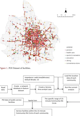
2) Reachability Analysis
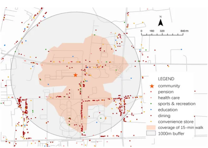
The data sets of road network in Lianchi and Jingxiu districts of Baoding are constructed using Arcgis software, and the service area analysis in network anal-ysis tool is used to simulate all the reachable locations that residents living in 1113 communities in Baoding downtown area can walk to in 15 minutes. There-fore, 1113 15-min pedestrian-scale life circles are formed. 15-min life circle ele-ments and POI data of each district were spatial joined, and the up-to-standard rate of facilities in each district was calculated. The flow chart is shown in Figure 2. The difference between this method and buffer analysis method is that it can reflect the travel status of residents to the greatest extent, shown in Figure 3.
3) Up-to-Standard Rate of Facilities in Communities
DOI: 10.4236/eng.2019.119041 596 Engineering Figure 1. POI Dataset of facilities.
Figure 2. The flow chart of the spatial accessibility algorithm.
the quality of residents’ daily life. Before calculating the up-to-standard rate of facilities, it is necessary to define the standard according to the needs of residents for different facilities. Its definition is as follows: 1) the overall standard: in cat-egories of convenience business, dining, education, medical treatment, sports & recreation and pension, at least one specific facility is needed to meet the stan-dard. 2) Sub-category standard: considering the substitution between facilities (e.g. Chinese restaurant and fast-food restaurant have strong substitutability, while kindergartens, primary schools and high schools are educational facilities for different age groups. There is no substitutability between them, and they need to exist at the same time).
Road data
Create a network database in feature
dataset
Create a Service Area analyst Layer Impedance: walk time(Minutes) Default Breaks: 15
Run the current analysis Load the location
data of each community
The specific range of 15-minute Community-life
Circle POI data of public service
facilities
Service facilities within the 15-minute Community-life Circle of each community
DOI: 10.4236/eng.2019.119041 597 Engineering Figure 3. 15-min pedestrian-scale circle of a community.
4. Results
1) Overall Layout of Facilities a) Convenient Commercial Facilities
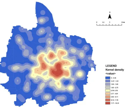
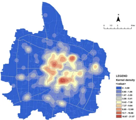
As can be seen from the kernel density analysis map of convenience commer-cial facilities, the convenience commercommer-cial service facilities in Baoding are main-ly concentrated in the downtown area. Places with the highest density are lo-cated in the Bell Tower, the Zhili Govern-general’s Office and the East-West Street subdistrict, which were once the most prosperous areas in Baoding. In ad-dition, there are many small-scale kernel districts, because apart from the tradi-tional downtown commercial districts, major residential functradi-tional districts are forming their own commercial service kernel districts, shown in Figure 4.
b) Dining Facilities
As can be seen from the kernel density analysis map of dining facilities, the distribution of dining facilities in Baoding is multi-kernel. These kernels lo-cate in the business circles near Dacige, Wanbo Plaza, and around Xiantian-xia-Baobai Shopping Square. The common feature is that it is the central area of residents’ activities and the densely populated area in each district, shown in Figure 5.
c) Educational Facilities
Educational facilities have a wide spatial distribution, covering most areas of the research area. This shows that the spatial distribution of educational facilities is relatively balanced. Areas with the most abundant facilities are located in Yu-hua subdistrict, ZhongYu-hua Road subdistrict and Hepingli subdistrict, where ad-vantages of educational resources are obvious, shown in Figure 6.
d) Sports and Recreational Facilities
DOI: 10.4236/eng.2019.119041 598 Engineering Figure 4. Kernel density of convenient commercial facility.
Figure 5. Kernel density of dining facility.
[image:7.595.264.485.519.707.2]DOI: 10.4236/eng.2019.119041 599 Engineering is relatively uniform, and the regional differentiation is obvious. Higher density locations are concentrated in Yuhua subdistrict, Xianfeng subdistrict, North Hancun Road subdistrict and Hanzhuangxiang subdistrict. In terms of POI, the number of sports venues (409) is far more than that of public recreational ve-nues (59), shown in Figure 7.
e) Pension Facilities
The number of POI of pension facilities (102) is relatively fewer, and there is a huge gap compared with other kinds of facilities. From its kernel density analy-sis, it can be seen that the core parts mainly locate in Hepingli subdistrict and Xinshichang subdistrict, and other places are scattered with some pension facili-ties, shown in Figure 8.
f) Medical Facilities
From the kernel density map of medical facilities, it can be seen that the den-sity of urban center is high and shows a concentrated distribution, and regional deficiency can be seen around the Qiyi Road. In areas near the second and third ring road, medical facilities are only distributed along the main roads with a low density, shown in Figure 9.
2) Up-to-Standard Rate of Facilities in Communities
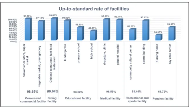
Six major categories are divided into 12 sub-categories, and calculated respec-tively, and in communities, the number of facility categories that meet the stan-dard are calculated, shown in Figure 10 & Figure 11.
[image:8.595.262.487.506.704.2]As can be seen from Figure 10, the up-to-standard rate of convenient com-mercial facilities, dining facilities and medical facilities are very high, 98.65%, 99.64% and 96.58% respectively. Although the total up-to-standard rates of edu-cational facilities and sports facilities are high, the up-to-standard rates of sub-categories including primary schools (59.3%), high schools (43.31%) and public cultural facilities (50.22%) are relatively low. The up-to-standard of total and sub-categories of pension facilities is poor.
DOI: 10.4236/eng.2019.119041 600 Engineering Figure 8. Kernel density of pension facility.
Figure 9. Kernel density of medical facility.
[image:9.595.208.543.517.704.2]DOI: 10.4236/eng.2019.119041 601 Engineering Figure 11. Number of up-to-standard categories.
According to the number of up-to-standard categories in communities, shown in Figure 11, only 7.63% of the 12 sub-categories have met the standard, and the average number of up-to-standard categories is 9. Among them, the nearer to the city center, the higher the up-to-standard rate is. The up-to-standard com-munities are mostly located in the vicinity of Qiyi West Road, Lekai North Street, Xiguan Street, Hengxiang South Street, Hongqi Street and Dongguan Street.
5. Suggestions for Urban Planning
1) Facility Layout Strategy Based on Reachability and Share
According to the up-to-standard rate of facilities, the overall allocation of community cultural facilities, pension facilities and some educational facilities in Baoding downtown area is insufficient. Therefore, it is necessary to improve the distribution of community cultural activities facilities, implement the indicators of pension services, and build educational facilities for all age groups. At the same time, according to the number of up-to-standard facilities in communities, we can accurately locate the missing facilities in each community, and then conduct precise construction.
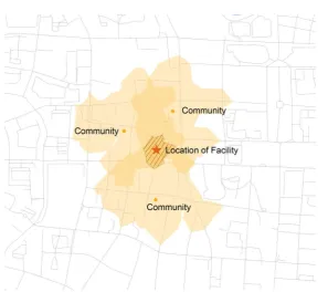
For the more frequently used facilities, they shall be allocated in areas within 15 minutes of walk, therefore these facilities can be used by more communities and residents, and to a certain extent, form sharing to improve the service of fa-cilities, shown in Figure 12.
2) Layout Strategy with Mixed Functions
DOI: 10.4236/eng.2019.119041 602 Engineering Figure 12. Facility distribution based on reachability and share.
and functions according to the size of the population, and combine the functions of community recreation, community pension, non-staple food market and oth-er functions to form an intensive and complex layout form for community resi-dents. Therefore, convenient and efficient “one-stop” life services are established to meet the different needs of residents, and high-quality and efficient commu-nity spaces are formed.
3) Differential Layout Strategy for Population Structure and Activity Features
Due to the differentiated, aging and highly educated people living in urban area, the lack of different facilities will bring different influences. While improv-ing the facilities in the community life circle, we should also establish standards of public service facilities that suit the features of population structure. For ex-ample, the community with a higher population aging rate should be allocated with more pension service facilities. At the same time, the facilities should be ra-tionally allocated according to the population density and residents’ activities, the range of life circle can be expanded in the suburbs, where the population density is relatively low.
6. Conclusion
DOI: 10.4236/eng.2019.119041 603 Engineering the optimization suggestions for the layout of facilities are put forward. The third and fourth-tier cities are the main body of China’s development and the “short slab” of modern city construction. Urban planners should seize the op-portunity, pay attention to people’s livelihood, quantitatively analyze the differ-ent needs of residdiffer-ents, implemdiffer-ent the life circle, and build a safe, civilized, con-venient and happy harmonious city.
Foundation Project
China’s National Natural Science Foundation Project “Research on Green Pro-ductive Renewal Strategy and Method of Existing Urban Residential Areas” (51708395).
Conflicts of Interest
The authors declare no conflicts of interest regarding the publication of this pa-per.
References
[1] Shanghai Planning and Land Resources Administration (2016) Shanghai Planning Guidance of 15-Minute Community-Life Circle.
http://ghzyj.sh.gov.cn/zcfg/ghss/201609/t20160902_693401.html
[2] Xiao, Z.P., Chai, Y.W. and Zhang, Y. (2014) Overseas Life Circle Planning and Practice. Planners, 10, 93-94.
[3] Xiong, W. and Xu, Y.L. (2010) The Urban Settlement Research in the Perspective of Public Facilities: A Case Study of Nanjing. Modern Urban Research, 12, 35-42. [4] Wu, Q.Q. (2015) The Exploration on the Dynamic Programming of Community in
Megacities from the Living Circle Perspective. Shanghai Urban Planning Review, 4, 13-19.
[5] Zhao, Y.Y., Zhang, B. and Zhou, F. (2018) Study on the Spatial Measurement of “15-Minute Community Living Circle” in Beijing Based on POI. The World of Sur-vey and Research, 5, 17-24.
[6] Chai, Y.W., Zhang, X. and Sun, D.S. (2015) A Study on Life Circle Planning Based on Space Time Behavioural Analysis: A Case Study of Beijing. Urban Planning Fo-rum, 3, 61-69.
[7] Xiao, J.H., Zhou, D.L. and Hu, J.P. (2018) Measurement And Evaluation Method of Community Life-Cycle Based on Decision Tree Theory: Panyu District of Guang-zhou. Planners, 3, 91-96.