Abstract
In the present study the authors try to em-phasize the interdependent relations that are established between space and poverty, as well as the modalities through which poverty policies can be optimized and implemented at the territo-rial systems level in accordance to the polycen-tric development model.
The fi rst goal of the study is to understand the way in which the complexity of the territory, in its structure and relations, infl uences in un-equal ways the territorial pattern of poverty and development. The concept of territorial poverty that we use in the present study transcends the usual connotation of poverty as a simple lack of different kind of resources towards the incapacity of the system to offer a wide range of impulses and solutions to the encountered problems and thus induce a state of underdevelopment.
The second goal is to understand in which ways the polycentric development theory can play a role in reducing poverty. In this sense the authors created a poverty index, and based on this index a polycentric development model was created for the North-Eastern region. This poly-centric development model has direct implica-tions for policy makers, as it highlights the areas that require the most attention and the develop-ment pole that should infl uence its development. By taking into consideration the results of this study, the next logical step for policy makers is to implement the necessary measures by consider-ing the relations between the development pole and the underdeveloped area that is under its in-fl uence area. In this respect tailor-fi t policies and measures can be applied in the effort to reduce poverty levels.
Keywords: territorial management, poverty, polycentric development strategy, space-indiffer-ent and space infl uenced, territorial disparities.
SPATIAL PROFILE OF POVERTY.
CASE STUDY:
THE NORTH-EASTERN
DEVE-LOPMENT REGION IN ROMANIA*
1Andrei SCHVAB
Radu PINTILII
Daniel PEPTENATU
Daniela STOIAN
Andrei SCHVAB
PhD., researcher, Interdisciplinary Centre for Advanced Research on Territorial Dynamics, University of Bucharest, Bucharest, Romania
E-mail: [email protected]
Radu PINTILII
Lecturer, Department of Human and Economic Geography, Faculty of Geography, University of Bucharest, Bucharest, Romania
E-mail: [email protected]
Daniel PEPTENATU
Associate professor, Department of Human and Economic Geography, Faculty of Geography, University of Bucharest, Bucharest, Romania
E-mail: [email protected]
Daniela STOIAN
PhD., researcher, Interdisciplinary Centre for Advanced Research on Territorial Dynamics, University of Bucharest, Bucharest, Romania
E-mail: [email protected]
* Acknowledgement: This work was supported by the proj-ects POSDRU/159/1.5/S/133391, POSDRU /89/1.5/S/58852 and UB 1322/2013 project.
1. Introduction
Poverty and underdevelopment are evidently a social phenomenon as human in-dividuals are the essential part and the key element in its structure and relations. But this fact doesn’t minimize the spatial aspect in the implication of poverty. In the last decades at EU level an ever more important focus has been put upon cohesion, gen-erally, and on territorial cohesion, specifi cally, by reducing poverty (European Com-mission, 2010; 1999).
The Leipzig Charter (2007), the ESDP (1999) and the Territorial Agenda of the EU 2020 (2011) stipulate that the main method for achieving a balanced territorial de-velopment should be based upon a polycentric urban structure. This fact refl ects the importance given to the territorial aspect in enhancing cohesion (indirectly said, this means also a reduction of poverty).
In this light an important aspect in the relation between territory and poverty is given by understanding the way in which the confi guration of the territorial system, its structure and relations infl uence, in diff erent ways, the territorial distribution of poverty. Knowing these types of relations and patt ern is an essential condition for the optimization and implementation of antipoverty policies at a territorial level.
One of the fi rst steps needed in order to link poverty and territory is to understand the way that poverty is conceptualized in relation to space. The att empt to analyze space as a structure enhancing or, on the contrary, blocking fl ows in the dissipation of various phenomena and processes is not ungrounded at all. Space may thus be in-terpreted as a dissipative structure (system) (Prigogine and Stengers, 1984) and as an optimally open thermodynamic system (Ianoş, 2000). Moreover, space has emerging properties (Kasinitz , 1999), more than the sum of the individual att ributes of the peo-ple living there.
The present article tries to individualize the most pauper areas inside this region, revealing thus the priority areas for structural and functional regeneration as part of a polycentric development model.
The authors set a theoretical framework that we consider capable of integrating space as an important factor in generating poverty or enhancing cohesion. After that, a general quantifi cation of poverty is made at EU level, revealing the most pauper regions in EU. As the indicator that sets the general frame is available only at regional level (NUTS 2) and at county level (NUTS 3) a more detailed index is elaborated in or-der to reveal the inside dynamics (at LAU 21, the lowest administrative unit possible).
In the next section we compare the results from the poverty index with the theoretical polycentric development model (the poverty index, the polycentric index and model
are calculated based on our own methodology and statistical data). According to the principles behind the polycentric development, this is the necessary framework that induces balanced development. In the discussion section we underline the role and infl uence of space upon the territorial distribution of poverty. In the fi nal section of the paper we summarize the main fi ndings and draft some policy recommendations in this regard.
2. Conceptualizing space in relation to poverty and underdevelopment
Roughly, there are two distinct ways to perceive the involvement of space in vari-ous matt ers such as regional and economic development, or, in the particular case of the present study, to reduce poverty in relation to polycentric development. In this respect, two assumptions can serve as starting points:
a) Space does not have an active role in the conceptualizations of socio-economic processes (Saunders, 1989).
b) Space has an active role in the conceptualizations of socio-economic processes (Massey, 1984; Brenner, 1999; Harvey, 2009).
The point of view expressed by Saunders and his followers (1989), stating that space is a stage, a framework, where various phenomena and socio-economic pro-cesses unfold, produces space-indiff erent theories and conceptualizations. On the opposite side, those who believe that space is an agent, part of the system, which contributes to those phenomena and socio-economic processes, produce space-infl u-enced theories and conceptualizations.
The diff erences between the two approaches are very important as, in the former view, space is outside the system, and it does not directly interfere in the relations between the components. In the latt er view, space is a component of the system, inter-acting, more or less vigorously, with the other components, bringing its contribution to the emergence of a new status-quo, of new structures, relations and functions.
However, there are also sociologists who acknowledge the importance of space, its dynamic role in structuring society, as well as the role of space in the dynamics of social and economic processes. In this respect, a special att ention is given to the role of public policies concerning the territorial systems’ dynamics. A series of actions, like decentralization, regionalization and the reduction of political infl uences in the administrative system, are considered solutions for the optimization of territorial sys-tems’ functionality (Mora and Țiclău, 2012).
3. Defi ning poverty (processes that generate poverty and underdevelopment)
Poverty has been – and still is – measured in countless ways so that the defi nition of poverty may be unequivocally considered arbitrary (O’Boyle, 1999; Unwin, 2007). In relating space and poverty, the scientifi c literature also mentions the term of place poverty (Powell, 2001), but the author of that concept only endows it with the mean-ing of absence of public and community services, so that this concept doesn’t fi t the purpose of the present study.
Postmodernist scientists understand poverty, and its emergence, as a social form induced by the processes of economic development (Yapa, 1996; Kay, 2009). This perspective is highlighted also by economists, who att ribute an ideological side to it: poverty is a consequence of the absence of economic growth, of free trade and a free market and therefore of the absence of democracy. Sachs (2005) considers that the most important eff ects of modern economic growth have been the rise of living standards and a bigger gap between the rich and the poor. In other words, economic growth failed to unlock poverty off its path-dependency.
The same conclusion was reached by a team of researchers led by Lobao, who, at the end of a study meant to show whether macro-level policies and theories in the United States during 1970-1990 managed to cut down inequities at the local level. The authors draw the conclusion that inequities at local level and their social deter-minants modifi ed litt le despite the Ford-inspired reorganization (Lobao, Rulli and Brown, 1999).
The current situation of under-developed regions is not exclusively the result of these spaces not being in geographic proximity (Torre and Rallet, 2005) of economic concentration centers, but also the result of the fact that these territories were pro-duced as distant (removed) from centers of power. Furthermore, even the central spaces are not homogenous, as they feature severe discontinuities in the large-scale distribution of income levels (Rigg et al., 2009).
Another important aspect is that the tools elaborated to tackle such specifi c prob-lems, like master plans and territorial development strategies (National Spatial Plan-ning Strategy, County Spatial PlanPlan-ning Strategy, General Urban Plan, Zonal Urban Plan and other master plans) only enhance ambiguity and reduce the impact of deci-sions assumed by planers, policy-makers and the community. In this regard Dragoș, Neamțu and Cobârzan (2012) consider that the implementation level could be en-hanced by including a general procedural administrative law.
Authors such as Harvey (2009), Gotham (2003), Unwin (2007), Rigg et al. (2009), Yapa (1996), Shrestha (1997) see the problem of reducing poverty or leveling social inequities by cutt ing down territorial disparities, by means of a confi guration of the space so that administrative and economic relations avoid path dependency and lock-in.
costs of transactions and thus stimulate economic growth (World Bank, 2009). It is the view that comes closest to taking into consideration the importance of space in the matt er of poverty and underdevelopment. According to ESPON 1.1.1, ESPON GROSSE and other offi cial EU strategies (Leipzig, ESDP, Territorial Agenda of EU 2020, Europe 2020 Strategy), the polycentric development model can be one of the proper territorial confi gurations mentioned in the WDR report.
However, we must eventually mention the words of de Castro (1977), who reached the conclusion that poverty is a universal phenomenon, unbound either by space or by time. Although poverty is universal, it acts with discrimination, ‘favoring’ the most vulnerable areas. The North-Eastern Development Region in Romania is such an area that proves the precariousness of regional development policies in a space where the relations deepening the state of poverty grow increasingly strong.
In order to assess the intensity of the poverty phenomenon, the present study be-gan with an analysis of indicators at EU scale, in order to frame the phenomenon of poverty into context and in order to realize that this phenomenon tends to expand and cover an increasing number of regions. One of the most relevant indicators (dis-tribution of GDP per capita) ranks North-East Moldova region among the most back-ward in Europe (Figure 1).
Figure 1: European GDP per Inhabitant 2009 (PPS/inhabitant), percentage of EU 27 average Source: Eurostat
low values are found in the two regions of the neighboring state, Bulgaria, a country that joined the European Union the same year as Romania did.
4. Methodology
Once that the theoretical frame is set, the focus is shifted upon measuring poverty and modeling a polycentric frame that should optimize and enhance territorial cohe-sion (this implies also reducing poverty).
Why is it important to highlight intra-regional disparities? Because seen from a mezzo-scale (the regional level in this case), the region is seen through average val-ues and the extreme situations remain hidden under this value. Going deeper, at mi-cro-scale (LAU 2 level), a heterogeneous dynamic is revealed, with very strong dis-parities. This fact is essential since the territorial drivers of development have to be individualized as well as the lagging territorial units. The central idea of the polycen-tric approach is to transfer development from the development pole to the underde-veloped territories. This is why, it is important to reveal the heterogeneous dynamics existing at LAU 2 level.
North-Eastern development region will be analyzed by developing a poverty index in order to reveal the detailed dynamic of poverty at a lower territorial level (LAU 2). The fi rst hypothesis is that poverty is not homogeneously distributed inside the North-Eastern Development Region, territorial disparities are very strong inside the region and thus poverty levels fl uctuate widely, with signifi cant diff erences be-tween diff erent counties but also between rural and urban areas. The second hypoth-esis is that there is a strong correlation between the poorest areas inside the region and the polycentric network; this fact means that territories (mostly rural) outside the big cities’ infl uence area are less developed.
The authors choose to develop a poverty index because the poverty rate used by EUROSTAT has no available data at LAU 2 level. At European level statistical data and indicators from the Statistical Offi ce of the European Commission (EUROSTAT) were studied and used. This poverty index is not commonly used at the lowest level of administrative units.
This index was calculated by means of four criteria that group several relative in-dicators, which describe demographic, economic, infrastructure and living standards matt ers in the analyzed area.
of sqm per inhabitant, the number of patients per physician and the ratio of arrivals and departures in a particular territory compared to its overall population. The indi-cators were aggregated using the following formula (Ianoş, 1997, pp. 103-110):
GDI = 50 +14(I1+I2+I3-……….-In-1-In)/n; where, GDI = the value of the general poverty index,
I1...In = the indicators used in the analysis, n = the overall number of the indicators analyzed.
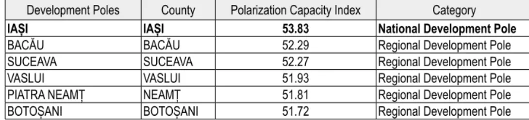
We also conducted an analysis of the intensity of the connections between the system of sett lements’ components, using fi ve criteria: size and demographic att rac-tiveness, economic power and competirac-tiveness, polarization capacity by means of higher-tertiary sector services, the number of lower-rank towns within the area of infl uence, territorial representativeness and the outlooks for supporting the consoli-dation of the regional system of sett lements. Aggregating these indicators resulted in a polarization capacity index (for the whole table see Annex 1), which was then used to rank the development poles of the North-Eastern Development Region.
Table 1: Polarization capacity index of the main cities of the region
Development Poles County Polarization Capacity Index Category
IAȘI IAȘI 53.83 National Development Pole
BACĂU BACĂU 52.29 Regional Development Pole
SUCEAVA SUCEAVA 52.27 Regional Development Pole
VASLUI VASLUI 51.93 Regional Development Pole
PIATRA NEAMȚ NEAMȚ 51.81 Regional Development Pole
BOTOȘANI BOTOȘANI 51.72 Regional Development Pole
A polycentric system was designed, depending on the polarization capacity index. This system comprises development poles and directions of polarization. Based upon this frame, a territorial management mechanism can be created in order to increase the level of development by transmitt ing indispensable information required by the system.
The cartographic representations in the present study were created using the Arc-GIS 9.3.1 platform, which used the statistical data supplied by local, regional, national and supra-national statistics bureaus (National Statistics Bureau and Eurostat).
5. Main fi ndings
in industry. This excessive industrialization process gradually led to a deterioration of the rural space.
The North-Eastern Development Region territory coincides (mostly) with that of the ancient historical province of Moldavia, consisting of six counties (Suceava,
Boto-şani, Bacău, Iaşi, Neamţ and Vaslui). The county seats of the six counties making up the region are among the biggest cities in the development region, which earned over time the status of regional development poles (see Table 1).
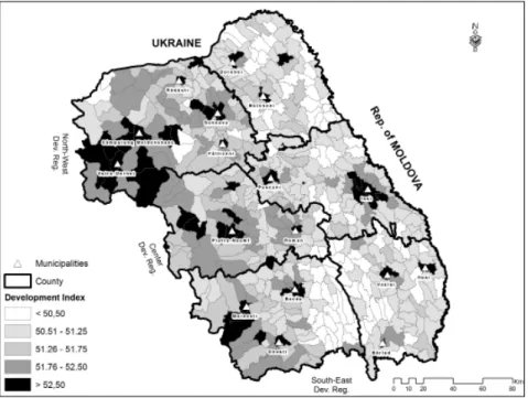
Figure 2: Territorial distribution of the poverty index in NE Development Region
In Figure 2 we can easily see the role that urban sett lements play in developing this region. Cities and municipalities are the economical drivers of the process of de-velopment, but this development is severely localized, it is not a generalized one. This is because the eff ects of development, with very small exceptions, stop at the fi rst ring of surrounding territorial administrative units. Also, we have to emphasize the fact that Siret valley acts as a major dividing axis between development and underde-velopment. More than 80% of the least developed administrative units are eastwards from this axis.
Taking into consideration the criteria that created the polycentric index, the city of Iaşi is the main polarization pole of the region, being a strong higher education, cultural and industrial centre in the region. For several centuries, it was the capital of the province. Nowadays, in Romania’s polycentric development strategy, it is a hub of national importance.
area is limited to the second, and in some cases, third line of communes surrounding it. Because of its fragile economy (severe decline of industry that triggered rural ex-odus and from there international migration), Iași is not capable to fi rmly structure the other territorial administrative units and induce them development. The role of Pașcani city in inducing development is limited and discontinuous (more developed communes stand together with the most poor ones). This mixture of more developed and poor communes, so close to a development pole, is a clear indicator of the lack of territorial cohesion and malfunctioning of what should have been polycentric devel-opment.
The city of Bacău is an important industrial centre, a centre that stands out by its capacity to win over the most numerous foreign investments. As a development pole, and fi rst rank city, it is included in the inter-regional category. Just like in the case of Iași city, Bacău manages to off er development impulses only on limited distance (the
fi rst ring of communes). The city is not capable of inducing generalized development across Siret valley.
Suceava and Piatra Neamţ, two county seats stand out, in particular, because of the touristic function they developed over time, as genuine points of departure to-wards natural and cultural tourist att ractions. The two cities induce a more general-ized development into their infl uence areas, but still, the distribution of developed and less developed administrative units refl ect a small polarizing capacity.
The cities of Botoşani and Vaslui developed predominantly along agricultural and trade lines. In terms of intraregional development, they are important light industry, textile industry and processing industry centers. These two cities have very limited capabilities to transfer development to their surroundings; in fact, they struggle to keep their local economies in a functioning state.
The above-mentioned urban areas, relatively bett er developed and with relatively higher living standards, stand in strong contrast with the rural areas, which feature higher poverty-index values (see Figure 2).
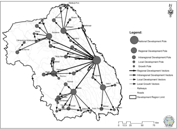
Using the polarization capacity index, a model for polycentric development was created, which comprises those territorial systems that should be capable, thanks to their functional complexity, to dissipate development into the subordinated territori-al systems.
The structure of the development pole network is the result of the industrializa-tion process, dominant before 1990, and of the post-1990 development of certain func-tions, such as the university function, which pushed certain cities ahead (Suceava).
Figure 3: Model of polycentric network in North East Development Region
The detailed analysis of the polarization capacity of towns in the North-Eastern Region highlights the intensity and directions of the relations between the compo-nents of the polycentric network, as well as the way one could intervene with a view to developing those relations, by means of a spatial projection of the process of decen-tralization.
The functioning of the polycentric network in this region is conditioned by the creation of an institutional network, a means to convey information from the level of supra-territorial systems to the local level, ensuring the reconfi guration of deci-sion-making impulses at the level of each decideci-sion-making authority, so that it would endow development strategies with specifi city.
not equal between the pole and the emerging area). Studies showed that there is a direct connection between the economic dynamics of the development pole and the surrounding area lagging behind (Peptenatu et al., 2012).
6. Discussions
Poverty is not evenly distributed inside the North-East Development Region; strong territorial disparities are present in one of the poorest European regions, so this means that some areas inside this region are even more underdeveloped than the regional average. This is an important aspect because it is an evidence of the lack of effi ciency in the present development policies and strategies. More importantly than this, the urban system of the region doesn’t work as a polycentric network, as concep-tualized in the European Spatial Development Perspective (European Commission, 1999).
Territorial cohesion is very weak and this will generate signifi cant social and eco-nomic tensions (this fact is already evidenced by the high international migration rate). Comparing the polycentric network and the poverty index map reveals a cor-relation, in the sense that the poorest regions are peripheral and away of the infl uence of big cities. Some exceptions are present, but can be explained if specifi c geograph-ical aspects are taken into consideration (the poor accessibility in Tutovei Hills and Central Moldavian Plateau).
Still, the results show that the cities, and especially the county residence cities, are not capable to polarize the territory by inducing them development. In many cases their development infl uence stops at the fi rst round of administrative territorial units that surrounds them.
Regarding policy implications, the confi rmation of the second hypothesis empha-sizes the need to enlarge the urban system of the region, but this can only be achieved through developing local economies. New urban centers have to emerge, but this should be done based upon their economic profi le and not thorough administra-tive appointments. Polycentric development requires also strong relations between the composing cities and equitable distribution of national funds and investments. Strong concentrations of capital, only in already developed centers, will increase the territorial disparities and will decrease its territorial cohesion.
7. Conclusions
The added-value of the present study is given by the fact that it off ers decisional support to policy makers by revealing detailed profi les of developed and underde-veloped areas. This study off ers policy makers a scientifi c tool to base their decisions upon. The results of this study points out to policy-makers that they should take into consideration that development and poverty are heterogeneously scatt ered across the region. Also, territorial specifi cities should be taken into account when trying to man-age the relations between development poles and underdeveloped areas.
The methodology of individualizing poverty and linking it to a polycentric devel-opment model can be extrapolated and applied to the other develdevel-opment regions in Romania, and not only. But policy and decision-making should be strictly tailored to the local and regional particularities of the territorial systems. All present conclusions and recommendations are derived only from the present case study. All extrapola-tions to other cases (other development regions) should be handled with caution and only after understanding the particularities of the relations, structure and functioning of that particular territorial system.
This study establishes a conceptual framework that can be used when viewing poverty from a geographical perspective in relation with the territory. The conducted analysis revealed that it is not advisable to conceptualize and regard space as a stage where economic and social processes unfold. On the contrary, it was demonstrated that the best way to regard space is more as an active component of the system.The concept of poverty may be approached from several angles but, in the present study, only those approaches were reviewed that were considered the most important in highlighting the evolutions within a region considered relatively homogeneous.
As far as the uneven development of the various regions of the country is con-cerned, the industrial development policy during the time of centralized-economy gradually led to an accentuation of economic fractures, especially those between rural and the urban areas. Despite the noticeable overall rise of the gross domestic prod-uct value and quality of life, compared with the number of inhabitants inside the North-Eastern Development Region and compared to the other development regions in Romania, the level of poverty remains the highest in the country and even in the European Union, in close competition with a region in Bulgaria.
The adaptive capacity of territorial poverty, in the North-Eastern Region, re-mained, at best, at a constant level compared to the other regions of the country. The lock-ins within the system are severe enough that, no matt er the policies enforced, be they during the centralized economy, or during the transition-type economy, the territorial poverty of the North-Eastern Development Region steadily remained at highest levels.
The analyzed territorial system managed to reach a level where it proves capable to remain inert to development policies that try to interfere with that state of path-de-pendence in which it fi nds itself. In other words, the relations between the com-ponents of the system reinforce each other (positive feedback), keeping the region locked into a stability zone characterized by high levels of territorial poverty.
From the present study as well as from the World Development Report 2009 the authors can conclude that the existing disparities and the state of poverty is an eff ect of the economic development process that acts discriminately. As long as territori-al systems that manage such problems regarding poverty and disparities don’t suc-ceed in applying laws, rules and good practices in an equal and equitable manner, those territorial disparities and the territorial poverty will deepen further. The pos-itive feedbacks will cumulate becoming a circular causality (Myrdal, 1957) leading the territorial system into lock-in. As the authors pointed out throughout this study, North-East Development Region shows the signs of deepening in a state from which it cannot break despite all the territorial development policies that underwent since the 60s.
The approach of disparities and poverty that emerge at the level of territorial sys-tems requires an integrated, interdisciplinary view in order to elaborate territorial management strategies capable of dealing with challenges imposed by the prolifer-ation of poverty, environmental degradprolifer-ations, pollution and economic restructuring (Braghinăet al., 2010; 2011; Peptenatu et al., 2010; 2012; Peptenatu, Pintilii and Dră ghi-ci, 2011; Peptenatu, Merciu and Drăghici, 2012).
As stated before, the study is based upon using a multi-criteria poverty index that includes all the development perspectives: economic, social, environmental and in-frastructural. Using this integrative poverty index, a clear image at the basic territori-al units’ level is unfolded, thus making it simpler to policy makers to take a decision based upon scientifi c evidence.
Conceptualizing space as a factor that infl uences the territorial impact of policies and based upon the identifi cation of underdeveloped areas at micro-scale, policy makers have the scientifi c tool to take the necessary measures and implement region-al development policies. This can be done by taking into consideration the relations between the development pole and the underdeveloped area that should be under its infl uence.
References:
1. ***, ‘Territorial Agenda of the European Union 2020. Towards an Inclusive, Smart and Sustainable Europe of Diverse Regions’, 2011, [Online] available at htt p://www. eu2011.hu/fi les/bveu/documents/TA2020.pdf, accessed on February 15, 2015.
2. Braghină, C., Peptenatu, D., Constantinescu, Ş., Pintilii, R.D. and Drăghici, C., ‘The Pressure Exerted on the Natural Environment in the Open Pit Exploitation Areas in Ol-tenia’, 2010, Carpathian Journal of Earth and Environmental Sciences, vol. 5, no. 1, pp. 31-40.
Development Region in Romania’, 2011, Iranian Journal of Environmental Health Science and Engineering, vol. 8, no. 4, pp. 343-352.
4. Brenner, N., ‘Globalization as Reterritorialization: The Re-scaling of Urban Gover-nance in the European Union’, 1999, Urban Studies, vol. 36, no. 3, pp. 431-451.
5. Cojanu, V., Pătru-Stupariu, I. and Dobre, R.R., ‘An Exploratory Study of the Regional Context of Competitive Development in Romania’, 2011, Transylvanian Review of Ad-ministrative Sciences, no. 33E, pp. 67-89.
6. de Castro, J., The Geopolitics of Hunger, New York: Monthly Review Press, 1977.
7. Dragoș, D., Neamțu, B. and Cobârzan, B., ‘Procedural Transparency in Rural Romania: Linking Implementation with Administrative Capacity?’, 2012, International Review of Administrative Sciences, vol. 78, no. 1, pp. 134-157.
8. ESPON, ‘ESPON 1.1.1, Potentials for Polycentric Development in Europe’, 2005, [On-line] available at htt p://www.espon.eu/export/sites/default/Documents/Projects/ES-PON2006Projects/ThematicProjects/Polycentricity/fr-1.1.1_revised-full.pdf, accessed on February 15, 2015.
9. ESPON, ‘GROSSE, Emergence of GROwth poles NETwork in South-East of Europe’, 2012, [Online] available at htt p://www.espon.eu/export/sites/default/Documents/Pro jects/TargetedAnalyses/GROSEE/GROSEE_Inception_Report.pdf, accessed on Febru-ary 15, 2015.
10. European Commission, ‘ESDP, European Spatial Development Perspective, Towards Balanced and Sustainable Development of the Territory of the European Union’, 1999, [Online] available at htt p://ec.europa.eu/regional_policy/sources/docoffi c/offi cial/re ports/pdf/sum_en.pdf, accessed on February 15, 2015.
11. European Commission, ‘Europe 2020. A Strategy for Smart, Sustainable and Inclusive Growth’, 2010, [Online] available at htt p://ec.europa.eu/eu2020/pdf/COMPLET%20 EN%20BARROSO%20%20%20007%20-%20Europe%202020%20-%20EN%20version. pdf, accessed on February 15, 2015.
12. Gotham, K.F., ‘Toward an Understanding of the Spatiality of Urban Poverty: The Ur-ban Poor as Spatial Actors’, 2003, International Journal of Urban and Regional Research, vol. 27, no. 3, pp. 723-737.
13. Harvey, D., ‘Reshaping Economic Geography: The World Development Report 2009’, 2009, Development and Change, vol. 40, no. 6, pp. 1269-1277.
14. Ianos, I., ‘Individualizarea și analiza disparităților intraregionale. Aplicație la Județul Alba’, Comunicări de geografi e, 1997, Universitatea din București, pp. 103-110.
15. Ianoş, I., Sisteme teritoriale - o abordare geografi că, Bucureşti: Tehnică, 2000.
16. Kasinitz , P., ‘Red Hook: The Paradoxes of Poverty and Place in Brooklyn’, in Hutchi-son, R. (ed.), Constructions of Urban Space, New York: Emerald Group Publishing, 1999, pp. 253-274.
17. Kay, C., ‘Development Strategies and Rural Development: Exploring Synergies, Eradi-cating Poverty’, 2009, The Journal of Peasant Studies, vol. 36, no. 1, pp. 103-137.
18. Leipzig Charter on Sustainable European Cities, 2007, [Online] available at htt p:// ec.europa.eu/regional_policy/archive/themes/urban/leipzig_charter.pdf, accessed on February 15, 2015.
Redistri-bution, 1970 and 1990’, 1999, Annals of the Association of American Geographers, vol. 89, no. 4, pp. 571-601.
20. Massey, D., Spatial Divisions of Labour, London: Methuen, 1984.
21. Mora, C. and Țiclău, T., ‘Public Administration Reform in Romania from a Leadership and Managerial Perspective’, 2012, Revista de Cercetare şi Intervenţie Socială, vol. 37, pp. 196-206.
22. Myrdal, G., Economic Theory and Underdeveloped Regions, London: Gerald Duckworth, 1957.
23. O’Boyle, J., ‘Toward an Improved Defi nition of Poverty’, 1999, Review of Social Econo-my, vol. 57, no. 3, pp. 281-301.
24. Peptenatu, D., Merciu, C. and Drăghici, C., ‘Characteristics of Entrepreneurial Profi le in Some Emergent Territorial Structures in Romania’, 2012, Actual Problems of Econom-ics, vol. 12, no. 138, pp. 448-458.
25. Peptenatu, D., Pintilii, R.D. and Draghici, C., ‘Environmental Risk Management of Ur-ban Growth Poles Regarding National Importance’, 2011, International Journal of Envi-ronmental Science and Technology, vol. 8, no. 4, pp. 737-746.
26. Peptenatu, D., Pintilii, R.D., Draghici, C. and Stoian, D., ‘Environmental Pollution in Functionally Restructured Urban Areas: Case Study – The City of Bucharest’, 2010,
Iranian Journal of Environmental Health Science and Engineering, vol. 7, no. 1,pp. 87-96.
27. Peptenatu, D., Pintilii, R.D., Draghici, C., Merciu, C. and Mateescu, R.D., ‘Management of Environment Risk within Emergency Territorial Systems. Case Study – The Infl u-ence Area of the Bucharest City’, 2012, Journal of Environmental Protection and Ecology, vol. 13, no. 4, pp. 2360-2370.
28. Powell, M., Boyne, G. and Ashworth, R., ‘Towards a Geography of People Poverty and Place Poverty’, 2001, Policy and Politics, vol. 29, no. 3, pp. 243-258.
29. Prigogine, Y. and Stengers, I., Order out of Chaos, New York: Bantam, 1984.
30. Rigg, J., Bebbington, A., Gough, K., Bryceson, D., Agergaad, J., Fold, N. and Tacoli, C., ‘The World Development Report 2009 ‘Reshapes Economic Geography’: Geographical Refl ections’, 2009, Transactions of the Institute of British Geographers, vol. 34, no. 2, pp. 128-136.
31. Sachs, J., The End of Poverty: How We Can Make it Happen in Our Lifetime, London: Pen-guin Books, 2005.
32. Saunders, P., Social Theory and the Urban Question, London: Hutchinson, 1989.
33. Shrestha, N., ‘On ‘What Causes Poverty? A Postmodern View’: A Postmodern View or Denial of Historical Integrity? The Poverty of Yapa’s View of Poverty’, 1997, Annals of the Association of American Geographers, vol. 87, no. 4, pp. 709-716.
34. Torre, A. and Rallet, A., ‘Proximity and Localization’, 2005, Regional Studies, vol. 39, no. 1, pp. 47-60.
35. Unwin, T., ‘No End to Poverty’, 2007, Journal of Development Studies, vol. 43, no. 5, pp. 929-953.
36. World Bank, World Development Report 2009: Reshaping economic geography, Washington DC: World Bank, 2009.
Annex 1
Polarization capacity index
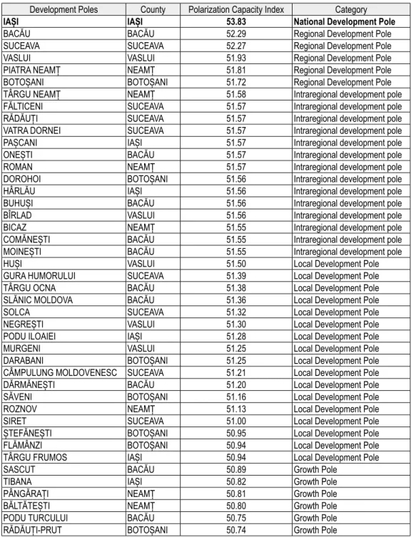
Table 2: Ranking of different types of growth poles in NE Development Region Development Poles County Polarization Capacity Index Category
IAȘI IAȘI 53.83 National Development Pole
BACĂU BACĂU 52.29 Regional Development Pole
SUCEAVA SUCEAVA 52.27 Regional Development Pole
VASLUI VASLUI 51.93 Regional Development Pole
PIATRA NEAMȚ NEAMȚ 51.81 Regional Development Pole
BOTOȘANI BOTOȘANI 51.72 Regional Development Pole
TÂRGU NEAMȚ NEAMȚ 51.58 Intraregional development pole
FĂLTICENI SUCEAVA 51.57 Intraregional development pole
RĂDĂUȚI SUCEAVA 51.57 Intraregional development pole
VATRA DORNEI SUCEAVA 51.57 Intraregional development pole
PAȘCANI IAȘI 51.57 Intraregional development pole
ONEȘTI BACĂU 51.57 Intraregional development pole
ROMAN NEAMȚ 51.57 Intraregional development pole
DOROHOI BOTOȘANI 51.56 Intraregional development pole
HÂRLĂU IAȘI 51.56 Intraregional development pole
BUHUȘI BACĂU 51.56 Intraregional development pole
BÎRLAD VASLUI 51.56 Intraregional development pole
BICAZ NEAMȚ 51.55 Intraregional development pole
COMĂNEȘTI BACĂU 51.55 Intraregional development pole
MOINEȘTI BACĂU 51.55 Intraregional development pole
HUȘI VASLUI 51.50 Local Development Pole
GURA HUMORULUI SUCEAVA 51.39 Local Development Pole
TÂRGU OCNA BACĂU 51.38 Local Development Pole
SLĂNIC MOLDOVA BACĂU 51.36 Local Development Pole
SOLCA SUCEAVA 51.32 Local Development Pole
NEGREȘTI VASLUI 51.30 Local Development Pole
PODU ILOAIEI IAȘI 51.28 Local Development Pole
MURGENI VASLUI 51.25 Local Development Pole
DARABANI BOTOȘANI 51.25 Local Development Pole
CÂMPULUNG MOLDOVENESC SUCEAVA 51.21 Local Development Pole
DĂRMĂNEȘTI BACĂU 51.20 Local Development Pole
SĂVENI BOTOȘANI 51.16 Local Development Pole
ROZNOV NEAMȚ 51.13 Local Development Pole
SIRET SUCEAVA 51.00 Local Development Pole
ȘTEFĂNEȘTI BOTOȘANI 50.95 Local Development Pole
FLĂMÂNZI BOTOȘANI 50.94 Local Development Pole
TÂRGU FRUMOS IAȘI 50.94 Local Development Pole
SASCUT BACĂU 50.89 Growth Pole
TIBANA IAȘI 50.82 Growth Pole
PÂNGĂRAȚI NEAMȚ 50.81 Growth Pole
BĂLTĂTEȘTI NEAMȚ 50.80 Growth Pole
PODU TURCULUI BACĂU 50.75 Growth Pole