DISCUSSION
This section is intended to -provide a forum for the discussion of papers published in our Journal by those working in similar fields of investigation and research. Such a discussion is expected to be of value not only to the actual workers in the concerned field, but also to a wider circle of readers interested in the progress of geological
studies.—Editor.
Paper on 'DEEP MAIN FAULTS IN SOUTH INDIA' by John C. Grady published in the Journal (Vol. 12, No. 1, March 1971).
Comments by J. B. Auden (Thurloe Square, London).
In a recent paper in this Journal (Vol: 12 No. 1) on ' Deep Main Faults in South India' Grady has produced an interesting map showing the relationship between fault zones, intrusions and mineral deposits. The straight Attur fault zone is given a length of 380 km and there are a number of straight and parallel faults and shears on either side. This work appears to have been based mainly on a photo-geological interpretation. The author does not seem, however, to be aware of other work which bears on this problem, references to which are given at the end of this present note.
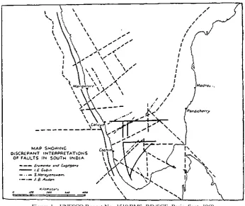
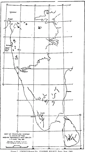
In the absence of systematic detailed geological surveys, the delineation of frac-tures in South India on the basis of air photographs and topographical maps is neces-sarily subject to personal opinion and selection. The fault pattern indicated by Gubin (1969, figs 17, 21) on the basis of geomorphology and seismicity is quite at variance with that of Eremenko and Gagelganz which was published in 1966. The writer has suggested yet other delineations in papers dated 1951, 1954 and 1969. Map 5 of the 1969 UNESCO report, reproduced herewith, (Fig. 1) indicates the various by no means concordant opinions on the disposition of fractures and faults. Map No. 4 of the UNESCO report, also reproduced here (Fig. 2), is an attempt to demar-cate the fractures, mainly on the basis of the excellent 1: 63360 topographical maps of the Surveys of India and Ceylon. My interest was first aroused in 1947 when investigating the Muttupatti dam site in the Anaimalai Hills and continued during tunnel studies in Maharashtra, and work on the Mahaweli Ganga Project for the F. A. O. Rome in 1965.
In studying the disposition of the drainage pattern, it is of course necessary to distinguish between erosion features which run parallel to the strike of the rocks, and those which are clearly unrelated to the strike. In areas where there are pronounced alignments of ridges it is reasonably safe to assume that the drainage pattern follows the strike of the formations of varied resistance to erosion, and is not necessarily connected with fractures. Straight stream courses which cut across the strike ridges on the other hand are likely to follow fracture zones. Where there is a triangular pattern of straight stream courses it is probable that there are at least two systems of fractures, besides the valleys which run parallel to the strike.
408 DISCUSSION
fractures run north-south (25 km) and NNW-SSW (13 km). In map 58 G/l there is a
NNW-SSE fracture 21 km in length while the strike is aligned WNW-ESE. In maps 58 B/7 + 8 + 12 the orographic axes are aligned mainly WNW-ESE, while there is a 60 km fracture aligned NNW-SSE, and a group of echelon north-south fractures extending for 55 km. More caution is required in the area of the Mettur dam where the NE-SW
strike ridges predominate over a subdued fracture-controlled drainage pattern. As. noted in the 1954 paper (p. 93) the observed vertical development of the fractures is. 6,200 ft. (1900 m) with unknown extensions to depth.
Figure 1. UNESCO Report No. 1519/BMS. RD/SCE, Paris. Sept. 1969.
Gubin is in favour of postulating a series of peripheral faults in South India which are considered by him to have caused the relative elevation of the Nilgiri, Palni and Anaimalai hills and the depression of the Palghat gap. The difficulty about this suggestion is that the scarps surrounding the elevated massifs appear to be erosion features, quite unrelated to faulting. This is well seen in the indented scarp 20-60 kilometres west of Mercara (12°25':75°44') and the associated Mangalore embay-ment. A similar indented disposition exists in the Palni hills east of Kodaikanal (10°14': 77°29'), and around Alavi 50 km south-east of Colombo.
410 DISCUSSION
are not found elsewhere. The Great Glen fault of Scotland certainly has a straight course for 200 km, but is not flanked by similar parallel faults. The major deep structural faults of the earth in a regional sense are not straight, even if over a limited stretch curvature may be absent. Examples are: Alpine fault system in New Zealand (1,000 km); Toktogul fault in Soviet Asia (41°48': 72°48'E, 800 km); Chaman fault in Afghanistan and West Pakistan (900 km), Ashkabad fault (37°58': 58°24', 800 km); Erzincan fault in Turkey (1,100 km); and San Andreas fault (1,000 km excluding marine extensions). These deep faults are all curved.
In India the Narmada system of intermittent faults, extending for 1,200 km, is manifestly curved in a regional sense. The Dauki fault which flanks the south side of the Shillong massif, is strongly curved east of longitude 92°45'.
It is too early at present to suggest the significance of the fracture pattern in South India in terms of crustal thickness. The African rift valleys vary in width between 40 and 70 km, with a mean width of 50 km. In a classic paper Hans Cloos (1939, figs. 15, 16) suggested that the width of the rift valleys may be related to the thickness of the lithosphere under the African plateau. The fractures in South India are not perhaps comparable to those of the African rift system, but they may have some relationship with the thickness of the upper part of the lithosphere. A quite common spacing of the major fractures in South India is 10- 12 km and it is possible that this is related to the upper part of the lithosphere crust. The system of fractures which cut the Deccan volcanics and dyke swarms has been discussed by me elsewhere (1951, pp. 145-146:1954, pp. 93-99; 1969, pp. 16-17) and is of a different type to those crossing the Archaean of the South Indian plateau massifs.
REFERENCES
AUDEN. J. B., (1951) The Bearing of geology on multipurpose projects Proc. 38th Ind. Sci.
Congr. Part 2, pp. 109-153.
(1954) Erosional patterns and fracture zones in Peninsular India. Geol. Mag. (London). 91, pp. 89-101.
(1969) Geological report on the seismicity of parts of Western India, including Maha-rashtra. Part 1 of UNESCO Report No. 1519/BMS. RD/SCE, Paris.
CLOOS, HANS, (1939) Hebung—Spaltung—Vulkanismus. Geol. Rundschau, 30. pp. 405-527. EREMENKO, N. A. and GAGELGANZ, A. A., (1966) New data on the tectonic framework of the
Indian Peninsula. Bull. No. 3, Oil and Natural Gas Commission, India.
GUBIN, I. E., (1969) Earthquakes and seismic zoning of Indian Peninsula. Central Water and Power Commission, New Delhi. Offset Press, pp. 1-80.
JACOB, K., NARAYANASWAMI, S., (1953) The structural and drainage Patterns of the Western Ghats in the vicinity of the Palghat Gap. Proc. Nat. Inst. Sci. Ind. 20, pp. 104-118.
Author's reply
Auden remarks that mapping fractures from aerial photographs is subject to personal opinion and selection. That this is true is shown by the varying fault systems produced by different geologists working in South India.
DISCUSSION 411
faults. Critical examination by the writer's Indian, Russian and German colleagues further reduced the total of personal factors.
At this point it seems important to define what it is that the writer put on the maps. They are faults, as defined in the A. G. I. Glossary of Geology, that is frac-tures and fracture zones which have undergone displacement. The key word here is
zones, as in the shear zones of the Canadian Shield, the Owen fracture zone, the
Kirkland Lake 'break' and so on. In each instance, it is understood that large blocks of the earth's crust moved past each other resulting in crush zones containing planar faults, shearing, tectonic breccia, intrusions, etc. These zones can be quite wide as at Attur where the breccia has a width of two kilometres.
Auden states that so far as he knows, such prolonged and parallel faults, cutting nonchalantly across the complex structures of the Archean are not found elsewhere. The writer would point out the tectonic zones west of Hudson Bay discovered in oil exploration (see map n° 1 reproduced here Fig. 1). These zones cut straight across the shield for two thousand kilometres. Associated with one zone near Lake Athabasca are parallel faults of the same order as in the Project area. The author of the map (Sproule, 1962) notes 'that it is worthy of particular mention that the faults and fractures under consideration are typical line or almost straight-line features'.
A recent map of the Indian ocean floor shows numerous long parallel faults. The Indian land mass itself appears to be part of an almost rectangular block of the crust bounded by megashears up to 5000 kilometres long (Dietz and Holden, 1970).
Many of the major transcurrent faults of the world are straight for at least 500 kilometres (Wilson, 1959, p. 40). The Atacoran fault in West Africa (mapped on air photos by the writer in 1967), is almost straight for about 500 kilometres. The straight carbonatite fault shown by the writer crossing the Indian Peninsula is shorter than some other known regional faults.
Auden believes the scarps surrounding the elevated massifs of the Nilgiri Hills are erosion scarps quite unrelatad to faulting. To the writer, the Nilgiris appear to be elevated fault block mountains and from this, the scarps are necessarily fault scarps.
Evidence for the writer's belief can be seen in the Project area on the western side of the Shevaroy Hills not far from the Yercaud road. Here there is an intrusion of peridotite directly in contact with charnockite at the base of the steep western scarp. The intrusion is one of a large group in the Salem area which are found in faults. To the writer the Shevaroy Hills are an elevated block bounded on the east and west by fault scarps. The eastern scarps of the Nilgiri Hills are similar to the Shevaroys in lithology and structure, the main difference being that they are higher. Because of this similarity, the writer considers the Nilgiri scarps to be fault scarps. One way to prove the point definitely would be to find deep-seated intrusions along the base of the Nilgiri scarps.
The faults in the Mettur region as pointed out by Auden are deep, with unknown extensions 'to depth. The ultrabasics and carbonatites nearby at Pakkonadu are evidence that the faults extend down to the mantle.
extended it 90 kilometres southwest from Sanalpatti, and predicted a carbonatite body at Pakkonadu, which was found soon after at the place indicated.
Auden's comments and supplementary list of references are much appreciated by the writer.
REFERENCES
DIETZ R. S. and HOLDE'N, J. C, The break-up of Pangaea, Scientific American, October 1970. SPROULE, J. C, Oil and gas occurrences, The tectonics of Canadian Shield. Roy. Soc. Canada,
Spec. Pub. No. 4, 1962.
WILSON, J. T., Physics and Geology, 1259, p. 40.
Paper 'ON TEXTURAL CHARACTERISTICS OF THE MUTH QUARTZITE OF SPITI AND KUTI REGIONS, CENTRAL HIMALAYAS' by Pradeep
Kumar Dasgupta published in the Journal (Vol. 12, No. 2, June 1971)
Comments by Vishwajit Gupta, (Centre of Advanced Study in Geology, Chandigarh).
In his paper the author has made an attempt to classify Muth Quartzite succes-sion into lower, middle and upper members on the basis of petrological characters, and has suggested an aeolian origin for the upper member. Gupta (1969) after detail-ed palaeontological and stratigraphical investigations of the Muth Quartzite succes-sion of Himalayas had concluded that the Muth Quartzite represents a shallow water marine Devonian succession extending from Kashmir to the western border of Nepal. It was also suggested that the Muth Quartzite probably represents blanket sand deposit of great linear extent, which might have accumulated in shallow seas adjacent to a shore line. The Muth Quartzite succession is interbedded with limestone and dolomites in parts of Spiti and Kumaon Himalayas, whereas it is found intercalated with dark slates near Basmai in Kashmir. The interbedded limestone and dolomites possibly formed local accumulation of shallow shelf carbonates between the blanket sands. The entire succession has been classified as belonging to ' Orthoquartzitic-Carbonate' facies of Pettijohn by Gupta (1969, p. 93).
Dasgupta has reported in his paper the presence of patches of iron staining in the middle member of the Muth Quartzite. Such patches are found in the entire Muth Quartzite succession exposed in different parts of the Himalayas; and at places these patches are associated with well preserved fossils. Rich assemblage of fossils has been reported from these quartzites by Gupta (1966, 1970, 1971), Gupta and Jain (1967), Gupta and Webby (1967), and Gupta and Bates (1968). The snow white quartzites which according to Dasgupta are confined only to the upper member are in fact found interbedded throughout the succession.
DISCUSSION 413
REFERENCES
GUPTA, V. J., (1966) Palaeontology, Stratigraphy and Structure of the Palaeozoic rocks of parts of the area southeast of Srinagar, Kashmir. Ph.D. thesis of the Panjab University, Chandigarh.
(1969) The Stratigraphy of the Muth Quartzite of the Himalayas. Journ.Ceol. Soc. lnd, v. 10, No. l,pp 88-94.
(1970) Muth Quartzite fauna from Kashmir. Res. Bull. (N.S.) Panjab Univ., v. 21, pts. I-II, pp. 1-22.
(1971) Indian Palaeozoic Fossils. Publ. Cent. Adv. Stud. Ceo!., Panjab Univ., No. 9, pp. 1-100.
GUPTA, V. J. and JAIN, S P., (1967) Lower Palaeozoic fossils from Lossar, Spiti. Pes. Bull. (N.S.), Panjab Univ., v. 18, pt. I, pp. 5-12.
GUPTA, V. J. and WEBBY, B. D., (1967) Middle Palaeozoic Brachiopods and Corals from Kashmir. Proc. Linn. Soc. N.S.W., Australia, v. 92, pt. 2, pp. 195-203.
GUPTA, V. J. and BATES, D. E. B., (1968) Schellwienella williami from the Muth Quartzite of
Kashmir Himalayas. Bull. Ceol. Soc. Ind., v. 5, No. 3, pp. 80-82. ,
Author's reply
The comments by Gupta could be expressed as related to (1) the environmental conditions for the Muth succession particularly in Spiti and Kashmir areas, (2) fossil content and stratigraphic status of the Muths and (3) reference to Gupta's work in this context.
It is emphasized that Gupta has not given any indication about his own obser-vations on the Muth Quartzite (sensu stricto) nor has he been able to refute the primarily aeolian character of the upper member of the succession in the type area. Though not directly related to the theme of the present paper, the writer's com-ments on the discussion by Gupta are recorded below:
(1) A cautious reading will reveal that the paper under discussion is devoted to the upper member of the Muth Quartzite of the type area. Following the basic principle, the stratigraphy and sedimentological characters of the quartzites have been worked out before an attempt is made to correlate the succession in other parts of the Himalayas.
It is well known that the conditions of sedimentation as also the rate of sedimen-tation may vary in space during a particular time unit. This might well have happen-ed in the case of the Muths. It may be emphasizhappen-ed that whatever be the final site of deposition, the sedimentological characters of the supermature quartz-arenites forming generally the upper member of the succession essentially are aeolian, the aeolian characters being acquired in a desert flat environment.
(2) The Muth Quartzite succession of the type area and Kuti is totally unfossili-ferous, and accordingly it has to be classified on a lithostratigraphic basis. The patches of iron staining do occur but are limited strictly to the middle member of the succession at Muth and Kuti. The stratigraphic status of the Muths as mentioned in the paper has been substantiated on the palaeontological data of the passage beds occurring conformably above and below quartzites. The detailed discussion on these aspects will be published in a separate contribution.
414
neighbouring areas was attempted. Thus there was no scope to refer to a mere review of older data (Gupta, 1969). A closer examination of the stratigraphy and structure of the early Palaeozoics of Kashmir is needed in order to clarify the age and relation-ship of the basal Muth Quartzite of Kashmir (Boucot and Gouri, 1969). The evalua-tion of the Muth equivalents of neighbouring areas is possible only when the succes-sion in the type area has been investigated in detail as has been done by the present writer (Dasgupta, 1971). As a first step towards correct and scientific correlation of the Muths, the writer's investigations have also been extended to Kuti areas (Dasgupta 1970, 1971).
In the light of the above discussion and available data at hand mentioned in the previous papers, the threefold classification as proposed by the writer is tenable in the type area of Spiti as well as in Kuti region, and related to the history of sedimen-tation of strata comprising Muth Quartzite Formation (Am. Com. on Stratigraphic nomenclature 1961).
REFERENCES
American Commission on Stratigraphic Nomenclature, (1961) Code of Stratigraphic nomenclature,
Am. Assoc. Petroleum Geologist Bull., v. 45, No. 5, pp. 645-660.
BOUCOT, A. J. and GOURI, K. L., (1969) Age and relationship of Basal Muth Quartzite of Kashmir, India, Geol. Soc. Am. Abstracts for 1968, sp. paper 121, pp. 33.
DASGUPTA, P. K., (1970) On textural peculiarities and environment of deposition of 'Muth Quartzite' from Kuti valley, Dist. Pithoragarh, U.P., Proc. 57th Session, lnd. Sci. Cong.,
Geol. & Geog. Section pp. 192.
(1971) Some observations from ' Exploration Pin Parvati 1970', a geological expedition in Spiti (H.P.), Central Himalayas, 58th Session, Proc. lnd. Sci. Cong., Geol. & Geog. Section p. 329.
GUPTA, V. J., (1969) The stratigraphy of the Muth Quartzite of the Himalayas. Jour. Geol.