ISSN Online: 2331-4249 ISSN Print: 2331-4222
DOI: 10.4236/wjet.2019.72B003 May 17, 2019 21 World Journal of Engineering and Technology
Comparative Study Using the 2-Hydrological
Models with the Global Weather in a Small
Watershed, a Case Study in the Upper Tha
Chin River Basin, Thailand
Sombat Chuenchooklin
1*, Udomporn Pangnakorn
2, Puripus Soonthornnonda
31Department of Civil Engineering, Water Resources Research Center, Faculty of Engineering, Naresuan University,
Phitsanulok, Thailand
2Department of Agricultural Science, Faculty of Agriculture Natural Resources and Environment, Naresuan University,
Phitsanulok, Thailand
3Department of Civil Engineering, Faculty of Engineering, Naresuan University, Phitsanulok, Thailand
Abstract
The hydrological study in the upstream of the Huai Khot Wang Man diver-sion canal in Huai Khun Kaew watershed of the Upper Tha Chin River Basin in Uthai Thani Province, Thailand was studied. The soil and water assessment tool (SWAT) and the integrated flood analysis systems (IFAS) applied to the analysis of flow at the outlet. The global weather data provided automatically by the models including land use covers and soil types. The climate forecast sys-tem reanalysis (CFSR) and the near real-time precipitation (GSMaP_NRT) used in SWAT and IFAS, respectively. The model sensitivity with Nash and Sutcliffe efficiency (NSE), correlation (R2), and root mean square error
(RSME) were applied. The monthly calibrated results from SWAT fitted to the observed data in 2007-2010 with 0.77, 0.88, and 9.08 m3/s, and verified in
2011 with 0.25, 0.61, and 14.30 m3/s, respectively. The daily results from IFAS
during a flood period in 2011 fitted to the observed data with 0.21, 0.39, and 34.32 m3/s. Both models showed applicable for efficient gate operation of the
diversion canal from this watershed to the Nong Mamong District in Chai Nat Province.
Keywords
Hydrological Model, SWAT, CFSR, IFAS, PUB
1. Introduction
The ungauged small or medium basin is generally difficult in flood estimation as How to cite this paper: Chuenchooklin, S.,
Pangnakorn, U. and Soonthornnonda, P. (2019) Comparative Study Using the 2-Hydrological Models with the Global Weather in a Small Watershed, a Case Study in the Upper Tha Chin River Basin, Thailand. World Journal of Engineering and Technology, 7, 21-26.
https://doi.org/10.4236/wjet.2019.72B003
DOI: 10.4236/wjet.2019.72B003 22 World Journal of Engineering and Technology Prediction in Ungauged Basin (PUB) [1]. Accurate estimates of stream runoff and other hydrologic quantities are needed for numerous purposes of water re-sources planning and management. The way of obtaining such estimates by modeling methods e.g. the rational and index-flood method, which can be found such as the Hydrologic Modeling System (HMS) [2]. The Soil and Water As-sessment Tool (SWAT) [3], is a river basin scale model developed to quantify the impact of land management practices on water, sediment and agricultural chemical yields in large, complex watersheds with various soil, land use and management conditions over long periods of time. SWAT main components in-clude weather, surface runoff, return flow, percolation, evapotranspiration, transmission losses, pond, and reservoir storage, crop growth, and irrigation, groundwater flow, reach routing, nutrient and pesticide loading, and water transfer. It has proven to be an effective tool for assessing water resource and non-point source pollution problems for a wide range of scales and environ-mental conditions across the globe with a wide range of other water use and wa-ter quality applications through the standalone or any geographic information system (GIS) including QGIS as QSWAT [4]. Moreover, an open source distri-buted rainfall-runoff hydrological model as the Integrated Flood Analysis Sys-tem (IFAS) developed by the Public Works Research Institute of Japan (PWRI) [5] which can be applied to the very large watershed, e.g. the Chao Phraya Basin, the Indus River Basin, the SEA countries [6], Pakistan [7], Taiwan [8], Japan, and others. Since the proper selection of grid sizing in the IFAS should be un-dertaken otherwise the longer computation time will occur [9].
Poor water management of existing diversion structures without any storage dam as a head-water source in the central plain of Thailand, including the Tha Chin and Sakae Krang River Basins was reported that it is not realized in the es-timation of the upstream discharges to those diversion structures as difficulty in gate management with full potential [10] [11]. Thus, this study aimed to analyze the stream flow discharge by using the QSWAT and IFAS to the Huai Khun Kaew Watershed at the upstream of the Huai Khot-Wang Man diversion point in the Nong Mamong District, Chai Nat Province. The study was a part of the overall research on the Development of Supporting Mechanisms for Budget Planning of Water Resources and Agriculture based on the Application of In-formation Technological Linkages in the Chai Nat Province which was spon-sored by the Thailand Research Fund (TRF) in 2016 [12].
2. Methodology
2.1. Modeling Setting in the Study Area
The study area, Huai Khun Kaew watershed, with a drainage area of 1066 km2
DOI: 10.4236/wjet.2019.72B003 23 World Journal of Engineering and Technology Irrigation Department (RID). The Huai Khot-Wang Man diversion canal was built to convey some part of a flood from existing watershed to the Nong Ma-mong District in Chai Nat Province.
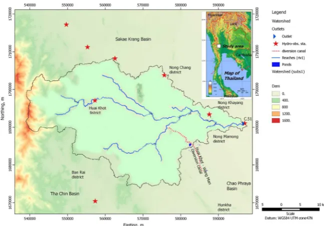
This study applied the two different hydrological models as for the compara-tive study in hydrography products throughout the outlet of the study area base on daily and monthly computation. The models were SWAT via QGIS platform as QSWAT [4] and IFAS [5] which applied to the Huai Khun Kaew Watershed in the Upper Tha Chin River Basin as shown in Figure 1.
Firstly, the IFAS model set applied with the 2-layers and 3-tanks with surface water, groundwater and river course tanks [13]. The sub-basins, river networks, and other components were applied by using the square grid-cell size of 300 m based on direct access to the global data sets e.g. digital elevation model (DEM): GTOPO30, land use covers: GLCC, and near real-time satellite mapping of pre-cipitation: GSMap_NRT [14] [15].
Secondly, SWAT’s water balance conceptual model, as well as all variables and parameters [16] [17], was applied in the study area based on the ASTER Global DEM (GDEM) with 30 m resolution [18]. The land use covers, soil data, and slope were generated to the 16-hydrologic response units (HRUs). The weather data were obtained from SWAT editor based on the Climate Forecast System Reanalysis (CFSR) [19].
2.2. Sensitivity of the Models
The Nash-Sutcliffe efficiency (NSE) is a normalized statistic that determines the relative magnitude of the residual variance as noise compared to the measured data variance as information. NSE is computed as shown in “Equation (1)” [20] where Yiobsis the ith observation for the constituent being evaluated, Yisim is the ith
simulated value for the constituent being evaluated, Ymean is the mean of
ob-served data for the constituent being evaluated, and n is the total number of ob-servations.
(
)
(
)
2 1 2 1 1n obs sim
i i
i
n obs mean
i i Y Y NSE Y Y = = − = − −
∑
∑
(1)The root mean square error (RSME) incorporates the benefits of error be-tween simulated result and observed data is computed as shown in “Equation (2)”.
(
)
21
n obs sim
i i
i Y Y
RSME
n
= −
=
∑
(2)3. Results and Discussions
DOI: 10.4236/wjet.2019.72B003 24 World Journal of Engineering and Technology Figure 1. Map of the Huai Khun Kaew watershed and stream layouts the Huai Khot-Wang Man diversion canal, and stream gauging stations in the Upper Tha Chin River Basin, Chai Nat and Uthai Thani Provinces.
Table 1. The model sensitivity from SWAT during the calibration and verification.
No. Monthly calibration and verification
Model sensitivity Calibrated in 2007-2010 Verified in 2011
1 NSE 0.77 0.25
2 R2 0.88 0.61
3 RMSE (m3/s) 9.08 14.30
Table 2. Model sensitivity verfied of IFAS and SWAT based on daily during a flood pe-riod 2011.
No. Verification of flood flow from 01 September to 10 November
Model sensitivity IFAS SWAT
1 NSE 0.21 0.71
2 R2 0.39 0.76
3 RMSE (m3/s) 34.32 9.73
The monthly calibration results from SWAT fitted to the observed in 2007-2010 with NSE of 0.77, R2of 0.88, and RMSE of 9.08 m3/s, respectively as
shown in Table 1. It had verified in 2011 with 0.25, 0.61, and 14.30 m3/s,
respec-tively.
Since IFAS was verified during a flood period in 2011 based on daily flow us-ing the range of those parameters which depends on the classification of tank’s characteristics [21] [22] fitted to the observed with NSE of 0.21, R2 of 0.39,
[image:4.595.205.541.515.594.2]DOI: 10.4236/wjet.2019.72B003 25 World Journal of Engineering and Technology verification in 2011 as shown in Table 2.
4. Conclusion and Discussion
The calibrated and validated results from SWAT and IFAS fitted to the observed in 2007-2011. Both models showed applicable for further efficient gate operation of the diversion canal from this watershed to the Nong Mamong District in Chai Nat Province. The applicable of IFAS is better to simulate daily flows to any point in the basin with the short period e.g. during a flood. However, it takes longer computation time if the model applied with time series for more than 1 year. The SWAT model seems to be very applicable and results are realized to the observed data. However, the complication of the calibration parameters of SWAT is more difficult than IFAS with less parameter. The inspection on mod-els sensitivity should be further carried out and compared to ground-based ob-servation data.
Conflicts of Interest
The authors declare no conflicts of interest regarding the publication of this pa-per.
References
[1] Blöschl, G. (2016) Predictions in Ungauged Basins—Where Do We Stand? Pro-ceedings of the International Association of Hydrological Sciences, Vol. 373, 57-60.
https://doi.org/10.5194/piahs-373-57-2016
[2] US Army Corps of Engineers (2017) (2016) Hydrological Modeling System HEC-HMS’s User Manual Version 4.2.
https://www.hec.usace.army.mil/software/hec-hms/documentation/HEC-HMS_Use rs_Manual_4.2.pdf
[3] Arnold, J.G. and Fohrer, N. (2005). SWAT2000: Current Capabilities and Research Opportunities in Applied Watershed Modeling. Hydrological Process, 19, 563-572.
https://doi.org/10.1002/hyp.5611
[4] QGIS’s Official Website. http://qgis.org/en/site/
[5] Public Works Research Institute (2017) Integrated Flood Analysis Systems: IFAS Version 1.2 User’s Manual. http://www.icharm.pwri.go.jp/research/ifas/.
[6] Shrestha, B.B., Okazumi, T., Miyamoto, M., Nabesaka, S., Tanaka, S. and Sugiura, A. (2014) Fundamental Analysis for Flood Risk Management in the Selected River Ba-sins of Southeast Asia. J. of Disaster Research, 9, 858-869.
https://doi.org/10.20965/jdr.2014.p0858
[7] Aziz, A. and Tanaka, S. (2011) Regional Parameterization and Applicability of Inte-grated Flood Analysis System (IFAS) for Flood Forecasting of Upper-Middle Indus River. Pak. J. Meteorol., 8, 21-38
[8] Kimura, N., Chiang, S., Wei, H.P., Su, Y.F., Chu, J.L., Cheng, C. and Lin, L. (2014) Tsengwen Reservoir Watershed Hydrological Flood Simulation under Global Cli-mate Change Using the 20 km Mesh Meteorological Research Institute Atmospheric General Circulation Model (MRIAGCM). Terrestrial. Atmospheric and Oceanic Sciences, 25, 449-461.https://doi.org/10.3319/TAO.2014.01.02.01(Hy)
DOI: 10.4236/wjet.2019.72B003 26 World Journal of Engineering and Technology Analysis System (IFAS) and Its Applications. World Environmental and Water Re-sources Congress, 1-10. https://doi.org/10.1061/40976(316)279
[10]Hungspreug, S., Khao-uppatum, W. and Thanopanuwat, S. (2000) Operational Flood Forecasting for Chao Phraya River Basin. Proceedings of the International Conference on the Chao Phraya Delta: Historical Development, Dynamics and Challenges of Thailand’s Rice Bowl, Bangkok, 12-15 December 2000.
[11]Japan International Cooperation Agency (1999) The Study on Integrated Plan for Flood Mitigation in Chao Phraya River Basin Summary and Main Report. Royal Ir-rigation Department Kingdom of Thailand.
[12]Thailand Research Fund (2018) Final Report: The Development of Supporting Me-chanisms for Budget Planning of Water Resources and Agriculture Based on the Application of Information Technological Linkages (ITLs) in Chai Nat Province. Water Resource Research Center of Naresuan University.
[13]Sayama, T., Ozawa, G., Kawakami, T., Nabesaka, S. and Fukami, K. (2012) Rain-fall-Runoff-Inundation Analysis of the 2010 Pakistan Flood in the Kabul River Ba-sin. Hydrological Sci. J., 57, 298-312.https://doi.org/10.1080/02626667.2011.644245
[14]Shrestha, B.B., Okazumi, T., Miyamoto, M., Nabesaka, S., Tanaka, S. and Sugiura, A. (2014) Fundamental Analysis for Flood Risk Management in the Selected River Ba-sins of Southeast Asia. J. of Disaster Research, 9, 858-869.
https://doi.org/10.20965/jdr.2014.p0858
[15]Shiraishi, S.Y., Fukami, K. and Inomata, H. (2009) The Proposal of Correction Me-thod Using the Movement of Rainfall Area on Satellite-Based Rainfall Information by Analysis in the Yoshino River Basin. Annual Journal of Hydraulic Engineering JSCE, 53, 385-390.
[16]SWAT’s Official Website. http://swat.tamu.edu/
[17]Dile, Y., Srinivasan, R. and George, C. (2018) QGIS Interface for SWAT (QSWAT Version 1.5). https://swat.tamu.edu/media/115806/qswat-manual_v15.pdf
[18]USGS (2017) ASTER Global Digital Elevation Model (GDEM), Land Cover Prod-ucts—Global Land Cover Characterization (GLCC).
https://earthexplorer.usgs.gov/
[19]Fuka, D.R., Walter, M.T., MacAlister, C., Degaetano, A.T., Steenhuis, T.S. and Eas-ton, Z.M. (2013) Using the Climate Forecast System Reanalysis as Weather Input Data for Watershed Models. Hydrological Processes.
https://doi.org/10.1002/hyp.10073
[20]Nash, J.E. and Sutcliffe.J.V. (1970) River Flow Forecasting through Conceptual Models: Part 1. A Discussion of Principles. J. Hydrology, 10, 282-290.
https://doi.org/10.1016/0022-1694(70)90255-6
[21]Fukami, K., Sugiura, Y., Magome, J. and Kawakami, T. (2014) Integrated Flood Analysis System: IFAS Ver. 2.0 User’s Manual. Japan PWRI-Technical Note Inc., 238-259.