63 | P a g e
Development of Wireless Sensor Network and Mobile
Routing Integration
Seema Sinha
Research Scholar, Department of Mathematics, Magadh University, Bodh-Gaya
Abstract:
This paper reveals that Robots, or in general, intelligent vehicles, require large amounts of data to adapt their behavior to the environment and achieve their goals. When their missions take place in large areas, using additional information to that gathered by the onboard sensors frequently offers a more efficient solution of the problem. The emergence of Cyber-Physical Systems and Cloud computing allows this approach, but integration of sensory information, and its effective availability for the robots or vehicles is challenging. This paper addresses the development and implementation of a modular mobile node of a Wireless Sensor Network (WSN), designed to be mounted onboard vehicles, and capable of using different sensors according to mission needs. The mobile node is integrated with an existing static network, transforming it into a Hybrid Wireless Sensor Network (H-WSN), and adding flexibility and range to it. The integration is achieved without the need for multi-hop routing. A database holds the data acquired by both mobile and static nodes, allowing access in real-time to the gathered information. A Human–Machine Interface (HMI) presents this information to users. Finally, the system is tested in real urban scenarios in a use-case of measurement of gas levels.
Keywords: wireless sensor network, mobile sensors, hybrid wireless sensor networks, Cyber-Physical Systems, urban environment monitoring
Introduction:
64 | P a g e
of vehicles through a better management of available resources. But one of the obstacles to the implementation of new transport strategies is the limited amount of information on urban traffic. WSNs provide a mean to improve the amount and quality of the data available for planning and management in ITSs.
The effectiveness of WSNs depends strongly on the network coverage and connectivity provided by the sensor deployment. Even if sensor nodes are usually easy to install, once they have been placed they only way to improve the information they acquire is to add new nodes, or to re-deploy the existing ones. Thus, the strategy to select the locations of the nodes becomes a key feature for the performance of WSNs.
A complementary strategy is to provide mobility to the sensor nodes, for example by including a method for replacing the sensor nodes if they present a malfunction. Another option is to mount the sensor nodes onboard vehicles or mobile robots. This approach is valid not only for urban applications, but also for other use-cases, like disaster robotics [6]. Mobility of the sensor nodes can be found in mobile ad hoc networks (MANETs), defined as a set of wireless mobile nodes characterized as self-adaptive and infrastructure-less [9]. In vehicular ad hoc networks (VANETs), or in general, in vehicular sensor networks (VSNs), moving vehicles and infrastructure become nodes of a dynamic network. In general, a WSN including both static and mobile sensor nodes can be considered a Hybrid Wireless Sensor Networks (H-WSNs). Several authors have proposed VSNs for real-time data acquisition and monitoring [8], including solutions like cloud computing, fog-based event monitoring or high resolution maps in urban environments.
The existence of mobile nodes in VSNs (or, in general, in H-WSNs) can make difficult to ensure coverage. The development of a H-WSN must pay special attention to this feature.
A classical approach to design a WSN considers a flat architecture. However, this kind of network does not allow for applications with mobile nodes, since a constant reconfiguration of the network is then required. A hierarchical architecture can improve performance in these cases, decreasing delays, while improving the reliability of data transmission and connectivity of the network. However, special attention must be paid to the organization of the network. For instance, the use of a mobile sink can allow for a longer lifetime of sensor nodes avoiding multi-hop data collection.
65 | P a g e Overview
The UIS is a static WSN. As such, it provides useful information on an area of interest, since it can be deployed with speed and flexibility to adapt to each case requirements. But once the network is deployed, the nodes stay at the same location. Obtaining additional information requires installing supplementary Transmitter nodes, and depending on the distance, also Receiver nodes, due to the limited range of ZigBee communications. Some use-cases require a different approach, such as the study of gas emissions. A significant amount of emissions in urban areas is linked to motor vehicles. Obtaining up-to-date information about the levels of some gases can be very relevant for traffic managers. But deploying a sensor network large enough to cover a whole city might be impractical. A way of obtaining the relevant data that traffic managers require is by means of sensors directly installed on vehicles. But some other applications require also the capability to measure environmental data in an adaptable fast way, such as in disaster robotics, where the collaboration with humans or dogs can be limited by the level of some gases. For those applications requiring additional flexibility in the acquisition of information, a hybrid version of the UIS network has been developed.
These features can be achieved by transforming the static WSN into a H-WSN by adding a Mobile node. The next sections describe the Mobile node architecture and implementation, and its integration with the WSN.
Architecture and Implementation
66 | P a g e
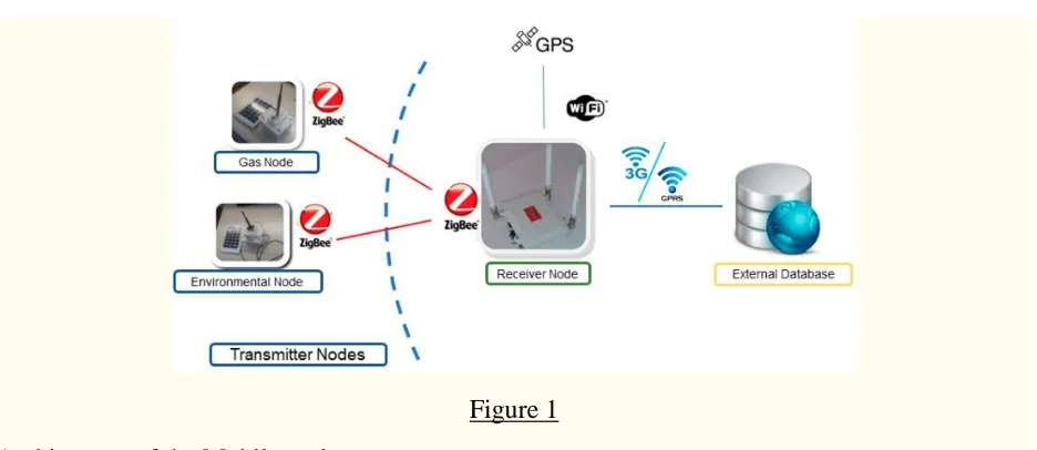
Figure 1
Architecture of the Mobile node.
An example set of nodes included in the Mobile node is shown in Figure 1. In this case, a Gas node and an Environmental node are included as the Transmitter nodes, together with the Receiver node. It is worth notice that Transmitter nodes may contain several sensors, which can be changed from one experiment to another depending on the mission requirements. For instance, the Gas node can be equipped with different sets of gas sensors, including CO2, CO,
O2, VOC or NH3.
The Mobile node has two possible working modes: local mode and networked mode. In both modes, the Transmitter nodes acquire and process data from the environment, and send them to the embarked Receiver node. The modes differ in the way that a frame is constructed prior to store it in the local table, and to synchronize it with the external database. The implementation had to meet the requirement of using the original nodes with as few modifications as possible. Thus, changes have been limited to the Receiver node software. These modifications have consisted in the creation of two additional software configurations according to the two different working modes. This software configuration has to be selected offline, previously to the start of an experiment. Thus, it is possible to increase the communication range of the existing sensor nodes without the need for integration of a new radio segment with the Transmitter nodes, or the development of new connection strings with the external server according to this new communication link. At the same time, it is possible to use any type of Transmitter node already in use by the static network.
Local Mode
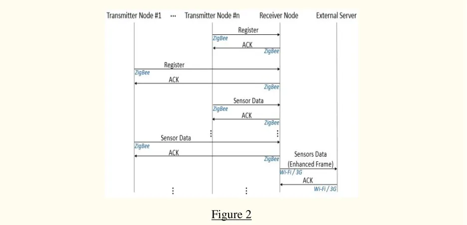
In this mode, the Mobile node is seen by the network as a single, multi-sensor node. To do so, an enhanced frame is constructed containing the information from all the sensors present in the Transmitter nodes within the Mobile node.
67 | P a g e
Synchronization is then performed with the external database (via 3G or Wi-Fi, if available), where the information appears as data from a single node. A simplified protocol message flow diagram for this working mode is shown in Figure 2.
Figure 2
Simplified protocol message flow diagram for the local mode.
Networked Mode
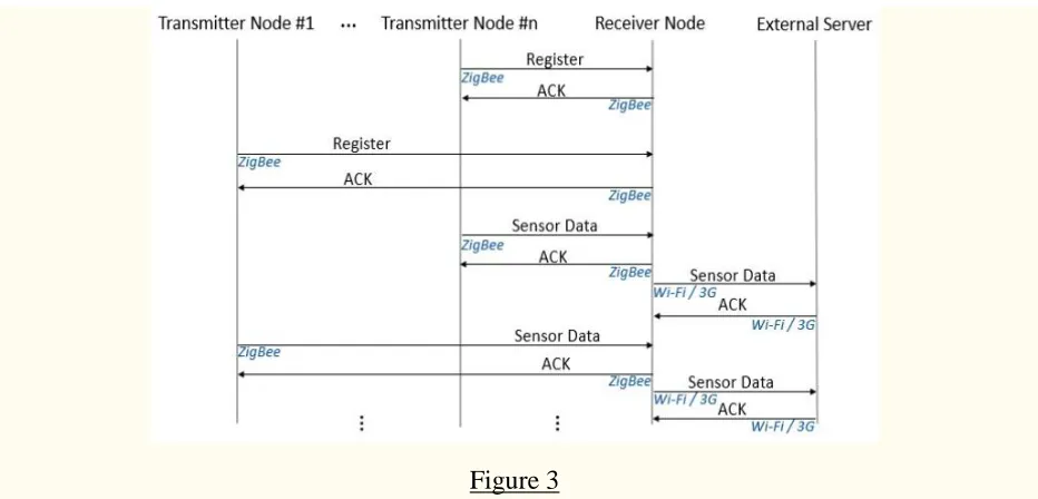
In the networked mode, when data from any of the Transmitter nodes are available, a frame is constructed and sent to the embarked Receiver node. A frame may contain information from one or several sensors from the same Transmitter node. The Receiver node updates its internal database, and then synchronization with the external database takes place via 3G, or Wi-Fi if it is available. A simplified protocol message flow diagram for this working mode is shown in Figure 3. Figure 4 shows examples of frames with data from a Gas node. The frame contains measurements from three sensors: NH3, temperature and humidity. Location is obtained by
68 | P a g e
Figure 3
Simplified protocol message flow diagram for the networked mode.
Integration with the H-WSN
69 | P a g e
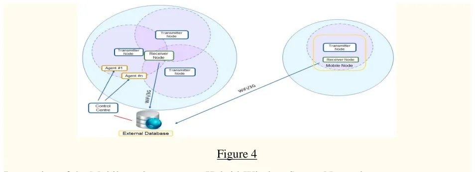
Figure 4
Integration of the Mobile node to create a Hybrid-Wireless Sensor Network.
The external database is the input for an HMI developed for this application using LabVIEW, making possible to present the information obtained by the different sensors, and related to their locations. The user can configure what sensors’ information is shown, according to the deployed nodes, including static nodes. For instance, it shows how the user can see the available measurements for CO2, CO, O2, NH3, ozone (O3), atmospheric pressure, relative humidity and
temperature, at the beginning of a route.
In contrast with the local mode in the networked mode the strategy allows for acquiring a larger amount of data, since the update and synchronization of the databases takes place every time a new data is obtained by any sensor. Thus, the slow dynamics of a sensor does not limit obtaining more data with a faster one.
Conclusion:
This paper concludes that a modular mobile node has been implemented, capable of using different sensors according to mission needs. The mobile node has been integrated with an existing static network, adding flexibility and range to it and transforming it into a Hybrid Wireless Sensor Network. Integration has avoided the need for multi-hop routing, which can reduce the operating lifetime of the nodes due to increased communication. Two different integration modes have been developed: local mode and networked mode. Data gathered with the mobile node have been presented to the user in real-time, by means of a Human–Machine Interface showing data from a database synchronizing the information gathered by the mobile node, which may include information from other static nodes as well. Finally, the system has been tested in real urban scenarios in a use-case of measurement of gas levels and environmental data.
References:
70 | P a g e
2. Ruano A., Silva S., Duarte H., Ferreira P.M. Wireless Sensors and IoT Platform for Intelligent HVAC Control. Appl. Sci. 2018;8:370. doi: 10.3390/app8030370.
3. Tonneau A.S., Mitton N., Vandaele J. A survey on (mobile) wireless sensor network experimentation testbeds; Proceedings of the 2014 IEEE International Conference on Distributed Computing in Sensor Systems; Marina Del Rey, CA, USA. 26–28 May 2014; pp. 263–268.
4. Ochoa S.F., Santos R. Human-centric wireless sensor networks to improve information availability during urban search and rescue activities. Inf. Fusion. 2015;22:71–84. doi: 10.1016/j.inffus.2013.05.009.
5. Curiac D.I. Towards wireless sensor, actuator and robot networks: Conceptual framework, challenges and perspectives. J. Netw. Comput. Appl. 2016;63:14–23. doi: 10.1016/j.jnca.2016.01.013.
6. Tuna G., Gungor V.C., Gulez K. An autonomous wireless sensor network deployment system using mobile robots for human existence detection in case of disasters. Ad Hoc Netw. 2014;13:54–68. doi: 10.1016/j.adhoc.2012.06.006.
7. Fernandez-Lozano J.J., Martín-Guzmán M., Martín-Ávila J., García-Cerezo A. A wireless sensor network for urban traffic characterization and trend monitoring. Sensors. 2015;15:26143– 26169. doi: 10.3390/s151026143.
8. Chen D., Liu Z., Wang L., Dou M., Chen J., Li H. Natural disaster monitoring with wireless sensor networks: A case study of data-intensive applications upon low-cost scalable systems. Mob. Netw. Appl. 2013;18:651–663. doi: 10.1007/s11036-013-0456-9.
9. Anjum S.S., Noor R.M., Anisi M.H. Review on MANET Based Communication for Search and Rescue Operations. Wirel. Pers. Commun. 2017;94:31–52. doi: 10.1007/s11277-015-3155-y.
10. Freeman J.D., Omanan V., Ramesh M.V. Wireless integrated robots for effective search and guidance of rescue teams; Proceedings of the 2011 Eighth International Conference on Wireless and Optical Communications Networks; Paris, France. 24–26 May 2011; pp. 6–10.
11. Zander J., Mosterman P.J., Padir T., Wan Y., Fu S. Cyber-physical Systems can Make Emergency Response Smart. Procedia Eng. 2015;107:312–318. doi: 10.1016/j.proeng.2015.06.086.
12. Lazna T., Gabrlik P., Jilek T., Zalud L. Cooperation between an unmanned aerial vehicle and an unmanned ground vehicle in highly accurate localization of gamma radiation hotspots. Int. J. Adv. Robot. Syst. 2018;15:1–16. doi: 10.1177/1729881417750787.