ISSN(Online): 2320-9801
ISSN (Print): 2320-9798
I
nternational
J
ournal of
I
nnovative
R
esearch in
C
omputer
and
C
ommunication
E
ngineering
(An ISO 3297: 2007 Certified Organization)
Vol. 3, Issue 7, July 2015
Use of Texture Orientation Based Vanishing
Point for Road Direction Estimation
Sabu Kamini1, Prof. Dr. M. H. Nerkar2
PG Student, Dept. of Electronics and Telecommunication, Government College of Engineering, Jalgaon, India1 Associate Professor, Dept. of Electronics and Telecommunication, Government College of Engineering, Jalgaon, India2
ABSTRACT: This paper is an effort towards promoting use of image processing in autonomous vehicles for on-road transportation. Being a cheaper and efficient way, image processing is attention seeking technique. A camera attached on the front side of vehicle captures images and estimates the direction and motion of the vehicle by processing them. This paper gives a brief overview of different methods used for path tracking. Texture orientation is used for the estimation of vanishing point as a global feature. The use of so obtained vanishing point is discussed for future vehicle movement. The turning angle for the vehicle is determined through a very simple geometry.
KEYWORDS: vanishing point; autonomous vehicle; road direction estimation; driver assistance; texture orientation
I. INTRODUCTION
Vehicle automation is a very important field under research. Vehicles with driver assistance systems and completely automated vehicles are some major topics under development.
Different detection and ranging based methods like RADAR and LIDAR are being tested for, but vision based methods are being proposed as an alternative as these are inexpensive.
For ill-structured or unstructured roads like in rural areas, vanishing point based vision methods have been proposed. Vanishing point, the end point of road in sight, is a global feature of the road images and hence assists direction estimation of unstructured roads too.
Movement of vanishing points with time can clearly state the direction of road. Therefore, drivers, while driving, are normally found to keep eyes on the vanishing point to determine the speed and direction of their vehicle. Vanishing point based methods as discussed in [1, 2, 3, 4] use this phenomenon for road tracking in driver assistance systems as well as automated vehicles.
After determining the vanishing point, the direction for robot movement is determined. The angle for movement is calculated. This paper uses vanishing point method for vision based navigation. The vanishing point estimation is performed as described in [4]. The Further work for determining movement direction has been dealt in this paper.
The vanishing point detection based approach assumes no prior knowledge about the environment and can cope with complex environmental situations like ground color variations, and different illuminations. The only thing required for vanishing point estimation is well-defined orientation of road.
The paper has been divided into five main sections. Section 2 briefly introduces different road navigation and direction estimation techniques. Section 3 makes detailed analysis of proposed method for estimating the vanishing point. Section 4 deals with the direction estimation using vanishing point, while Section 5 enlists performance merits and demerits of the novel algorithm.
II. RELATED WORK
ISSN(Online): 2320-9801
ISSN (Print): 2320-9798
I
nternational
J
ournal of
I
nnovative
R
esearch in
C
omputer
and
C
ommunication
E
ngineering
(An ISO 3297: 2007 Certified Organization)
Vol. 3, Issue 7, July 2015
methods used for navigation and road area estimation involve hough transform based edge detection, color feature based image segmentation, modeling based image classification, and training based navigation, etc.
Different approaches used for road direction tracking involve edge based road boundary extraction. Lane markings detection and also the road area estimation help extract road region boundaries. The road area estimation is also used to determine centreline of the road which denotes the direction of road [5]. The robot is thus guided on centreline.
Latest methods [1,2,3] for road direction estimation use the concept of vanishing point. Vanishing point is the point in the image where the road edges appear to intersect. A typical road picture is shown in fig.1. Here, the vanishing point has been indicated with red colored circle.
Fig.1 Vanishing point shown with red colured circle.
Different techniques are used for vanishing point estimation. This paper uses technique discussed in [4] for estimating the vanishing point. The vanishing point so obtained can then be used to determine direction of road and its curvature. It may also be used to determine centerline of road and boundaries are also determined using vanishing point.
III.PROPOSED ALGORITHM
A. Vanishing Point Estimation:
The algorithm proposed here in uses texture orientation for estimating the vanishing point. Many of the improvement considerations in [1] and [3] have been worked out. Gabor filters are used for vanishing point estimation.
This paper uses four Gabor filters with equally spaced orientations. The orientations are, therefore, 0, π/4, π/2 and
3π/4. The Gabor filter kernels have parameters λ = 4√2, γ = 2, σ = λ/4, ψ =
The input image is convolved with the Gabor filter so as to obtain the Gabor energy response and the local dominant orientation is calculated at each pixel p(x, y).
The physical distance and the angular distance have large impact on the participation in voting. The impact is controlled by providing different weightage to different orientation and different distances.
The angular weightage is provided such that vote becomes 0 for horizontally oriented candidate and is maximum i.e. 1 for the candidates vertically above the pixel p(x, y). The weightage is more for near vertical orientations and reduces towards horizontal orientations. Similarly, vote is weighed based on physical distance such that candidate near the pixel gets higher vote and the candidate far away from the pixel gets smaller vote. The weightage decreases the vote exponentially with distance.
Secondly, the vertically up-down objects also tend to change the vanishing point position. This is mainly because the vertical candidates get maximum votes during voting phase. Therefore, candidates directly above the pixel under consideration are not voted.
ISSN(Online): 2320-9801
ISSN (Print): 2320-9798
I
nternational
J
ournal of
I
nnovative
R
esearch in
C
omputer
and
C
ommunication
E
ngineering
(An ISO 3297: 2007 Certified Organization)
Vol. 3, Issue 7, July 2015
B. Road Direction Estimation:
After determining the vanishing point, if we keep eyes on the movement of vanishing point with time, the direction of vehicle can be estimated.
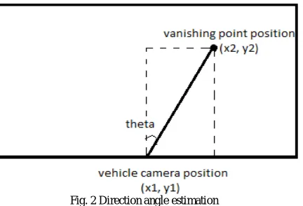
This paper assumes the camera position exactly at the center of vehicle. Therefore, the vehicle can be assumed to be positioned exactly at the bottom centre of the captured image. The vehicle direction can then be considered as the direction of vehicle as pointing towards the vanishing point.
The bottom centre and the vanishing point are connected to get a line as shown in fig. 2. The movement angle is decided based on trigonometry formula (1).
tan(90- theta) = (y2-y1)/(x2-x1) ... eq.(1)
Here, theta is the angle through which the vehicle must turn. If theta is positive, the vehicle is to turn right, else the vehicle should take left turn.
Fig. 2 Direction angle estimation
Further motion of robot/vehicle needs to be updated on per frame basis. Next frames will provide updated information and the vehicle movement should be recalculated based on it. Prior calculations may be considered while updating the results.
IV.SIMULATION RESULTS
The algorithms were coded in MATLAB 7.10.0 (R2010a). The computer used is HP PC model with Intel(R) Core(TM) i5-2500 CPU processor @3.30GHz loaded with operating system Windows 7 Professional Service Pack 1.
ISSN(Online): 2320-9801
ISSN (Print): 2320-9798
I
nternational
J
ournal of
I
nnovative
R
esearch in
C
omputer
and
C
ommunication
E
ngineering
(An ISO 3297: 2007 Certified Organization)
Vol. 3, Issue 7, July 2015
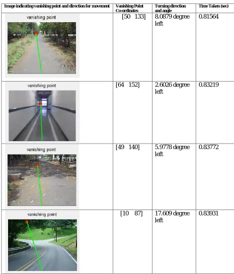
Table 1. Experimental Results
Image indicating vanishing point and direction for movement Vanishing Point Co-ordinates
Turning direction and angle
Time Taken (sec)
[50 133]
8.0879 degree
left
0.81564
[64 152]
2.6026 degree
left
0.83219
[49 140]
5.9778 degree
left
0.83772
[10 87]
17.609 degree
left
ISSN(Online): 2320-9801
ISSN (Print): 2320-9798
I
nternational
J
ournal of
I
nnovative
R
esearch in
C
omputer
and
C
ommunication
E
ngineering
(An ISO 3297: 2007 Certified Organization)
Vol. 3, Issue 7, July 2015
[10 41]
27.3567 degree
left
0.83421
The second column in the results table gives the co-ordinates of the vanishing point obtained. The third column indicates the turning direction with angle. Time required for the complete processing of the corresponding image is indicated in column 4.If the image size is changed, some impact has been observed on the results obtained. The parameter D (normalization distance) needs to be selected according to the image size and resolution of the camera under consideration. For the results in table 1, the value of D has been considered to be 50.The results show that the algorithm works best for well structured roads. Even in the indoor environments (row 2) for robot navigation, the technique gives best possible candidate for vanishing point.
The performance is, however, found to degrade with the presence of shadows (row 4). Orientation of shadow edges gets considered while calculating the vanishing point. If the effect of shadows can be nullified, the vanishing point obtained will be purely due to the road objects. This forms the future scope of the project.
V. CONCLUSION AND FUTURE WORK
The vanishing point estimation proposed here with keeps check on the exact vertical orientations. This leads to better accuracy in vanishing point estimation. The road direction is determined and the turning direction is estimated there of using this vanishing point. The results are found to be very matching with very small time requirement.
The only problem to be faced is the misguiding shadows which cause wrong orientations to disturb the results. The problem can be solved using shadow detection and removal. This is the future scope for the paper.
REFERENCES
1. Kong H., Audibert J. and Ponce J., ‘General Road Detection from a Single Image’, IEEE Transactions on Image Processing, vol. 19(8), pp 2211-2220, 2010.
2. Rasmussen C., ‘Grouping Dominant Orientations for Ill-Structured Road Following’, Proceedings of IEEE Computer Vision and Pattern Recognition, pp 470-477, 2004.
3. Moghadam P. and Dong J., ‘Road Direction Detection Based on Vanishing-Point Tracking’, Proceedings of IEEE/RSJ International Conference on Intelligent Robots and Systems (IROS), pp 1553-1560, 2012.
4. Sabu K., and M. H. Nerkar, “Vanishing Point Estimation for On-Road Navigation,” International Journal of Emerging Technology and Advanced Engineering, vol. 5 April 2015, pp. 73-77.
5. Isa K. and Jantan A. ‘An Autonomous Vehicle Driving Control System’, International Journal of Engg., 21(5), 855-866, 2005. 6. Gonzalez R., Woods R. and Eddins S., ‘Digital Image Processing using MATLAB’, Pearson Education, South Asia, 2009. 7. Gonzalez R. and Woods R., ‘Digital Image Processing’, Pearson Education, South Asia, 2007.
BIOGRAPHY
Sabu Kaminiis a post graduate student in the Electronics and Telecommunication Department, Government College of Engineering, Jalgaon, MS, India. Her specialization is Digital Systems. Her research interests are Computer Vision and Image Processing, Video Processing, etc.