International Journal of Emerging Technology and Advanced Engineering
Website: www.ijetae.com (ISSN 2250-2459, ISO 9001:2008 Certified Journal, Volume 3, Issue 4, April 2013)
421
Location Based Automatic Profile Changer and
Mobiminder
Bharti Ahuja1, Mayuri Deshmukh2, Ruchika Borhade3, Pooja Nikam4
1,2,3,4Department of Computer Engineering, Sir Visvesvaraya Institute Of Technology Chincholi, Nashik, Tal.Sinnar,
Dist-Nasik, Maharashtra.
Abstract— In Today’s Mobiles ADOC Network (MANET)
since almost mobiles are used in each and every aspect of life and having a mobile is a common feature. But it is required to update the update the location of mobile i.e. the individual holding the mobile his location needs to be traced.S econdly, the profile of the mobile changes automatically when you entered a specific area. A Mobile minder i.e. reminder needs to be updated when to reach a particular location which helps u or someone getting updates on when you reach the specific location / area. This location updates needs to happen in a neighborhood region or at a remote location. The mobile ad-hoc network (MANET) is a network in which each node maintains its frequency by updating its location information within the neighborhood region (NU).As soon as the location of a particular area which are set matches with the GPS co-ordinates Location server is updated (LS U) and profile is activated. Reminder of particular task which is fed in your mobile also alerts you. The communication between the operations cost in the location update and the performance ungained of the target application due to location inaccuracies imposes a critical question for nodes to decide the optimal strategy for location update.
Keywords—GPS , Google Map, Location Update , Markov decision processes , Android.
I. INTRODUCTION
The android is the latest and upcoming operating system in the market and application related to this operating system are much faster and easier to work[1]. The use of this operating system is increasing due to its versatility and capability of satisfying the user[1]. The purpose of this system would be capable of taking decision on profile setting to be changed depending on the zone/location[5] in which the mobile would be operating and send a sms accordingly to remote mobiles and occasionally updates in ringtone profile. Further it would be enhanced with the locational reminders. This application allows user to input locations by typing in the addresses or by selecting location from Google maps[4] as one would do in Google maps (maps.google.com)[3]. Along with the locations, the user can specify a relative order among his locations.
[image:1.612.382.498.277.407.2]The output produced is either a text message alert to particular sim number or the permission to update the profile.
Fig 1: Andriod Window
In this system we are going to develop android applications which are location based. Also we will develop some of the application which is occasional. The system updates the profile automatically after entering to a restricted zone. It updates the profile to a desired mode on a particular location. It text alerts to neighborhoods after entering or leaving the particular zone. It reminder in the form of Alerts after entering to a specified zone/area.
II. RELATED WORK
There are different Operating systems for the mobile phones like bada, symbian, palm & many more. But Android provides some advantages & features too which makes it unique & popular among the cell phone users.
International Journal of Emerging Technology and Advanced Engineering
Website: www.ijetae.com (ISSN 2250-2459, ISO 9001:2008 Certified Journal, Volume 3, Issue 4, April 2013)
422
Such degree of customization is still a dream in android. Also android comes from a company which is nascent in the mobile arena while bada is born of experience. High degree of processing capability is endowed in bada. More complex and demanding apps can be moulded from bada and many more differences exist.
Android devices have great range of applications. These applications are made available to the user through a market place. But in Symbian devices one can use these applications only.
As a third party application. we can use wi-fi for a long time in android devices than in symbian.
Android is smart operating system which is very convenient and useful for the user.It is primarily design for touch screen mobile. It is an open source operating system. Applications are developed in the Java language using the Android software development kit (SDK) [3]. The SDK
includes a comprehensive set of development tools,
including a debugger, software libraries, a handset
emulator based on QEMU, documentation, sample code,
and tutorials. The officially supported integrated
development environment (IDE) is Eclipse using the Android Development Tools (ADT) plugin[3]. Android has nine versions and our application is supported by all the version starting from Froyo.
GPS stand for Global Positioning System[4], This system is thourly supported by Android application.GPS service in Android is Built-in.GPS helps the people to locate the particular area of their interest in a few seconds which has made it convenient for people to even travel unknown places because of its navigation facility.GPS works in any weather condition and anywhere in the world 24 hours a day. There is no fee for subscribing it and changes.GPS system uses a triangulation to calculate user’s exact location[5].Todays GPS receivers are extremely accurate because a parallel multi-channel design. The accuracy of GPS receiver is upto 15m. GPS works by a constellation of at least 24 satellites 2, each orbiting the earth every 12 hours, at a height of 20200 km. These satellites broadcast their own location, and a very precise time signal.
Many cities have maps that show where you are, for tourists and other people who don’t know the area. This shows the need for maps with information[4]. A simple map of the area the user is in can be one of the most useful features of any location based system. The Nulaz maps, while quite a hassle to develop, can give a good overview of the current location, and can be useful in finding, which show the same location[2].
The satellite or areal picture is mainly for fun. But it can be useful, as some areas such as parks are less planned out in the maps, but can be recognized in the photos. The maps can also be used in conjunction with other features, to show where items (such as movie theaters, restaurants, etc) are located[5].
III. SYSTEM DESIGN
You need different profiles when you are at home, offices or any other work place. For this you have to change your profile manually which is very tedious work which required mental alert system too. To overcome this if there is fun way of changing the profile by using default profile manager which is updated with the help of locations.
The goal of system design is to produce a model or representation that exhibit, commodity and delight. It provides information about the application domain for the software to be built. It describes the internal details of software.
In the proposed system satellite views of the map points the location accuracy of latitude and longitude based on the location are mapped[4]. This is possibly is to define location radius profile changed by the user manually is given the highest priority and the application will not try to overwrite user changed profile.Defualt profile is applied when you are not within the saved location[5].SMS alert goes to the neighbourhood region. Reminder about the task is activated.
[image:2.612.334.554.485.678.2]The proposed system uses the following applications:
International Journal of Emerging Technology and Advanced Engineering
Website: www.ijetae.com (ISSN 2250-2459, ISO 9001:2008 Certified Journal, Volume 3, Issue 4, April 2013)
423
A. GPS/ Google Map
[image:3.612.329.574.118.332.2]GPS, which stands for Global Positioning System, is the oldest computerized locating technique and in widespread use, as it’s the only technique with a worldwide (outdoor) coverage.The uses of GPS is must for the application to run.the[4] . As soon as the co-ordinates of the location which are set by the user are match with help of GPS,the profile is updated. GPS Coordinates i.e. latitudes & longitudes would be received from GPS satellite on ANDRIOD mobile with GPS functionality or GOOGLE Maps[4] functionality on mobiles.GPS Coordinates latitudes and longitudes can be entered manually when the system is to be tested on Android Emulator[3].
Fig 3: Location shows by using GPS B. MANET
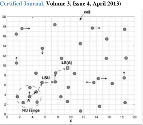
MANET is useful for wireless routing applications both static and dynamic technologies. It is self configuring infrastructure less networks for mobile devices. In MANET location of nodes are not fixed and a node is to be frequently updated by the information. There are two basic location update operations at node.
To update the location information in the neighborhood
region which is usually implemented by local
broadcasting[5].
To update the nodes location information at one or multiple distributed servers.Eg. The location server update which is usually implemented by unicast and multicast of the location information msg via multihop routing in MANET[6].RFID Attendance System.
Fig 4: Illustration of the Location update model in MANET
The location update problem at a node can be formulated as Markovin We consider MANET in finite region. The whole region is divided in small cells and locations of node are identified by the index of cell. Nodes in a network are mobile and follows the mobility model of markovin.Each node in the network needs to update its information in neighborhood region and also to location server.[6]
The priority knowledge of MDP (Markovin Decision Process)[2] is necessary.The decisions for location update need to be carried out in each carried out. It is natural to formulate the location update problem as discrete time sequential decision problem. Under the given Markovin mobility module this decision problem can be covered.
C. System Features (Functional Requirements)
Following are the features to be implemented in the proposed system:
Implementation of a Mobile Policy / Profile with following functionality
[image:3.612.123.221.306.409.2]International Journal of Emerging Technology and Advanced Engineering
Website: www.ijetae.com (ISSN 2250-2459, ISO 9001:2008 Certified Journal, Volume 3, Issue 4, April 2013)
424
b.Identify locations / Zones in whose entry a updates must happed to a Remote location (Location server updates)[6] / neighbor update in form of a SMS, i.e. after entering / leaving from an area a SMS to be sent to another mobiles.
c. Profile / ring tones to be changed automatically during a preconfigured day i.e. 15th August, 26th Jan, Rakshabandhan, Holi etc.
d.Alerts to be displayed after entering to a specified zone/area.
The proposed system would be capable of taking decision on profile setting to be changed depending on the zone/location in which the mobile would be operating and send a SMS accordingly to remote mobiles[6].
Following are the snapshots as follow:
Fig.5: Login Window
Fig.6: Location finding window
International Journal of Emerging Technology and Advanced Engineering
Website: www.ijetae.com (ISSN 2250-2459, ISO 9001:2008 Certified Journal, Volume 3, Issue 4, April 2013)
425
Fig.8:Detailed Information about profile
IV. CONCLUSION
This project includes the entire study of Location based automatic profile changer and mobiminder. It gives the information of location service in a mobile ad -hoc network (MANET), where each node needs to maintain its location information by frequently updating its location information within its neighboring region, which is called neighborhood update (NU), and occasionally updating its location information to certain distributed location server in the network, which is called location server update (LSU).
In this ways it provided a systematic way of profile changing according to the GPS coordinates and also reminds us about it and makes the use of mobile to the user more convient.
REFERENCES
[1 ] M. Mauve, J. Widmer, and H. Hannes, “A Survey on Position-based routing In Mobile Ad Hoc Networks,” Proc. IEEE Network, pp. 30-39, Nov./Dec. 2001.
[2 ] Y.C.T seng S.L..Wu,Wh,liao & C.M.Chao,”Location Awerness in ad-hoc wireless mobile network ” proc.IEEE Computer.pp.46-25,June2001.
[3 ] Eclipse - http://www.eclipse.org/ [4 ] Google http://www.android.com/
[5 ] IEEE T ransaction on Mobile computing vol,10,no.5, may 2011 Optimal stochastic location updates in mobile ad-hoc networks. [6 ] Optimal Stochast ic Location Updates in Mobile Ad Hoc Networks
![Fig 2: System Architecture[1][2].](https://thumb-us.123doks.com/thumbv2/123dok_us/8730743.886773/2.612.334.554.485.678/fig-system-architecture.webp)