International Journal of Emerging Technology and Advanced Engineering
Website: www.ijetae.com (ISSN 2250-2459,ISO 9001:2008 Certified Journal, Volume 4, Issue 7, July 2014)
360
Pothole Detection System using Machine Learning on Android
Aniket Kulkarni
1, Nitish Mhalgi
2, Sagar Gurnani
3, Dr. Nupur Giri
41,2,3,4
V.E.S. Institute of Technology, Mumbai-74
Abstract—This paper investigates an application of mobile sensing: detection of potholes on roads. We describe a system and an associated algorithm to monitor the pothole conditions on the road. This system, that we call the Pothole Detection System, uses Accelerometer Sensor of Android smartphone for detection of potholes and GPS for plotting the location of potholes on Google Maps. Using a simple machine-learning approach, we show that we are able to identify the potholes from accelerometer data. The pothole detection algorithm detects the potholes in real-time. A runtime graph has been shown with the help of a charting software library ‘AChartEngine’. Accelerometer data and pothole data can be mailed to any email address in the form of a ‘.csv’ file. While designing the pothole detection algorithm we have assumed some threshold values on x-axis and z-axis. These threshold values are justified using a neural network technique which confirms an accuracy of 90%-95%. The neural network has been implemented using a machine learning framework available for Android called ‘Encog’. We evaluate our system on the outputs obtained using two, three and four wheelers.
Keywords— Machine Learning, Context, Android, Neural Networks, Pothole, Sensor
I. INTRODUCTION
Android, owned by Google, has become the most widespread mobile operating system in use today. The availability of an intuitive IDE like Eclipse along with a robust SDK that is updated regularly, Android certainly does not lack any charm for eager developers- amateurs and seasoned professionals alike.
Context aware services separate the present from the past. Intelligent programs making use of data acquired from a host of sensors like GPS chip, Accelerometer, Gyroscope etc. have made life a lot easier. They are ubiquitous in the modern day, from location services to games.
In this paper, we aim to evaluate a Pothole Detection System, developed by us which involve processing sensor readings and judging the accuracy of the system using a neural network.
The following sections provide sufficient background and insight into our aim to develop a system that detects potholes, logs their location and creates a document in a distributable format that can be utilized to upload to a centralized server or sent to concerned authorities immediately.
II. RELATED WORK
A. Pothole Patrol [4]
Eriksson et al, describe an application of mobile sensing: detecting and reporting the surface conditions of roads. It describes a system and associated algorithms to monitor this important civil infrastructure using a collection of sensor-equipped vehicles. This system, which is called as the Pothole Patrol (P2), uses the inherent mobility of the participating vehicles, opportunistically gathering data from vibration and GPS sensors, and processing the data to assess road surface conditions.
B. Real Time Pothole Detection using Android Smartphones with Accelerometers [1]
Mednis et al, describe a mobile sensing system for road irregularity detection using Android OS based smart-phones. Selected data processing algorithms are discussed and their evaluation presented with true positive rate as high as 90% using real world data. The optimal parameters for the algorithms are determined and the recommendations for their application are described.
C. Pothole Detection and Warning System using Wireless Sensor Networks [3]
This paper aims at proposing a novel pothole detection system which assists the driver in avoiding potholes on the roads, by giving prior warnings. Interest in Intelligent Vehicle Systems comes from the problems caused by traffic congestion worldwide and a synergy of new information technologies for simulation, real-time control and communications networks. The architectural design further proposes a low response time, low maintenance and deployment cost solution to this problem.
III. REQUIREMENTS AND SCOPE
The scope of this system, as well as the requirements can be described with the following points:
1. Applications utilizing the machine learning
implementation should have permissions matching those of the sensors used.
2. The raw sensor data should be evaluated in real time. 3. User should be asked if collected data should be
International Journal of Emerging Technology and Advanced Engineering
Website: www.ijetae.com (ISSN 2250-2459,ISO 9001:2008 Certified Journal, Volume 4, Issue 7, July 2014)
361
4.Native communication tasks of the device should not be hampered.
5.Data collected by components should be made
accessible to other applications, as well as components.
6.The algorithm designed should avoid
resource-intensive techniques to determine result.
IV. POTHOLE DETECTION SYSTEM
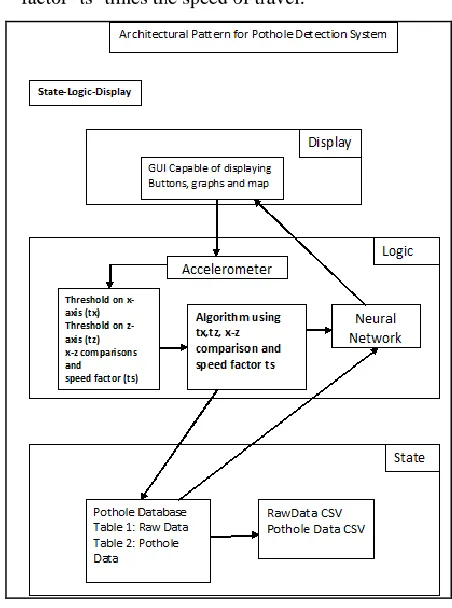
The pothole sensor plug-in monitors the changes in the acceleration in order to detect potholes. For this, the user needs to have an Android smartphone. The device‘s built-in accelerometer is used to collect the x, y and z axis accelerations. The native GPS (Global Positioning System) chip is used to collect location co-ordinates. As seen in Figure 1, this is included in the Display module, with appropriate buttons to carry out the task. The implemented plug-in should be generic so that it can be used along with other context-aware applications.
The pothole detection algorithm is good, in terms of speed and accuracy. This algorithm accepts the training set and displays the pothole scenario in the particular area. Specific details related to the algorithm are present in following paragraphs, and one can get the gist of how values required by the algorithm are collected and used, by noting the Logic module in Figure 1.
When the user starts his/her journey, they launch the pothole detection Android application. The application, which has the algorithm plug-in running, detects the potholes on the roads while user is driving. It monitors for changes in the acceleration. The application adds the current time, geographic co-ordinates and pothole statistics to the event log.
When the user finishes his/her journey he/she taps ‗Stop‘ and they are presented with the event log. This log should be maintained in the database. The State module in Figure 1 captures this aspect. It contains information related to the values saved in the database, and in the distributable ‗.csv‘ format.
The benefit of this application is that it provides the condition of the roads along with their locations. The distributable event log can be used to alert the local authorities following which, they can fix the bad road and resolve the complaint. This can ultimately result in a safer and a more enjoyable driving experience.
A. Proposed Algorithm
1) Algorithm for Detection of Potholes
• A high pass filter removes low-frequency components
from acceleration signal in x-axis and z- axis.
• Peak acceleration in the z-axis is a prime
characteristic of significant road anomalies. This filter rejects all windows with a peak z-acceleration less than a threshold ‗tz‘.
• A true pothole event with large z-peak acceleration should produce a significant peak in the x-axis.
•
At high speeds, even small road anomalies can create [image:2.612.335.561.299.603.2]high peak acceleration readings. This filter rejects windows where the peak z acceleration is less than a factor ‗ts‘ times the speed of travel.
Fig. 1. State-Logic-Display diagram of Pothole Detection System
2) Implementation of the Pothole Detection Algorithm
International Journal of Emerging Technology and Advanced Engineering
Website: www.ijetae.com (ISSN 2250-2459,ISO 9001:2008 Certified Journal, Volume 4, Issue 7, July 2014)
362
1. Use a high-pass filter
final float alpha = (float)0.8;
gravity[0] = alpha * gravity[0] + (1 - alpha) * event.values[0];
gravity[1] = alpha * gravity[1] + (1 - alpha) * event.values[1];
gravity[2] = alpha * gravity[2] + (1 - alpha) * event.values[2];
2. High-pass effect: Removing of low-frequency component
accelValues[0] = event.values[0] - gravity[0]; accelValues[1] = event.values[1] - gravity[1]; accelValues[2] = event.values[2] - gravity[2];
3. z-peak
Assume threshold on z-axis. (tz) Reject the reading if AccelZ<tz
4. x-z comparison
Assume threshold on x-axis (tx) Reject the reading if AccelZ<tx*AccelZ
5. Speed factor
Assume speed factor ‗ts‘.
Reject the reading if AccelZ<ts*speed.
6. If above conditions are satisfied then it is a pothole. Else, it is not a pothole.
B. Neural Network
This system also deploys a neural network to implement Machine Learning on Android, and to improve the efficiency and accuracy of the detection of potholes.
An Artificial Neural Network (ANN) is an information processing paradigm that is inspired by the way biological nervous systems, such as the brain, process information. It is composed of a large number of highly interconnected processing elements (neurons) working in unison to solve specific problems.
C. Parameters for the Neural Network
1. Number of input layers = 3 2. Input1= acceleration on x-axis 3. Input2 = acceleration on x-axis 4. Input3 = acceleration on x-axis 3. Number of hidden neurons = 6 4. Number of output layers = 1 5. Output1= potholedecision. 6. Activation Function = Sigmoid
7. Neural Network Algorithm = Back propagation
V. IMPLEMENTATION AND RESULTS
[image:3.612.357.530.236.436.2]The result is an Android application which offers facilities to collect the data from sensors by recording a journey, to display the data using graphs using AChartEngine, and to run the data through the neural network deployed. There‘s also a feature provided to plot the detected potholes on Google Maps and to email the data that has been collected.
Fig. 2. Screenshot of the App homescreen
[image:3.612.353.533.459.685.2]International Journal of Emerging Technology and Advanced Engineering
Website: www.ijetae.com (ISSN 2250-2459,ISO 9001:2008 Certified Journal, Volume 4, Issue 7, July 2014)
363
The red graph in Figure denotes the instantaneous accelerations on x-axis. The green and blue lines do the same on y- and z-axis respectively. The jerks or impulses evident in the figure are probably potholes, which will be confirmed or denied by the underlying algorithm.
There are different files generated after data collection and processing, viz.,
1. PotholeData.csv: All the data captured by accelerometer of the device
2. FilteredPotholeData.csv: Shows the records which are detected as pothole by the algorithm
3. PotholeData_traim.csv: Shows the input data for training
4. NeuralNetwork.csv: Final Output of the Neural Network The advantage of having the data available in ‗.csv‘ format is easy distribution to the authorities or for usage by other applications.
Finally, the neural network calculates the error rate by performing 6000 iterations. The average error rate obtained in our testing was 4.86 %. That translates to an accuracy of over 95%.
Looking back to the requirements of the system, we come to the conclusion that the implementation satisfies the requirements satisfactorily. Appropriate permissions were matched to gain access to sensors, and to manipulate the values returned. The system achieved after implementation is a real-time system that returns the result in a matter of seconds after evaluating the readings and calculating the results in real time.
A provision for sending the set of recorded values, with the result via e-mail is present, which satisfies the requirement of making the collected data available to appropriate authorities, if needed. Native communication tasks of the Android device are not hampered in the least, and can be carried out without any fuss.
[image:4.612.358.529.133.363.2]The most resource intensive stage of the system is the evaluation by the neural network. This is directly proportional to the size of the data set collected and therefore, for the time period that the sensors are actively collecting data. This definitely depends on the hardware specs of the Android device, but it was observed that it took only about 5 seconds for the neural network to evaluate about a hundred values. This is highly satisfactory, considering the objective of the Pothole Detection System.
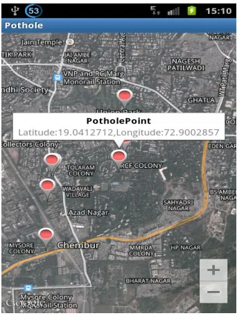
Fig. 4. Plotting detected potholes in Google Maps
VI. LIMITATIONS
The Pothole Detection System, although very promising, has certain limitations, as listed below:
A. Human Error
First of all, we admit, that a human operator pressing a button during the test drive is subject to multiple errors due to both technical limitations and human factors.
B. Network Provide accuracy
NETWORK_PROVIDER's location is not always accurate because it is based on cell-site triangulation. This provider determines location based on availability of cell tower and Wi-Fi access points. Results are retrieved by means of a network look-up. The accuracy of NETWORK_PROVIDER depends on number of base stations around you and the quality of the signal.
C. Centralized Databases
International Journal of Emerging Technology and Advanced Engineering
Website: www.ijetae.com (ISSN 2250-2459,ISO 9001:2008 Certified Journal, Volume 4, Issue 7, July 2014)
364
VII. CONCLUSION
The Pothole Detection System is an attempt to provide its users with better knowledge about the routes of their transportation. Despite hardware differences in terms of GPS accuracy, accelerometer sampling rate and noise, we postulate that accurate pothole detection is possible. We believe that our experience will help to improve efficiency and reduce time and effort for further experiments using the Android platform for vehicular sensing researchers. With further work in this field, it is possible for this project to play a proactive part in improving road conditions in developing countries.
REFERENCES
[1] "Real time pothole detection using Android smartphones with
accelerometers," A. Mednis, G. Strazdins, R. Zviedris, G. Kanonirs, L. Selavo, dcoss, pp.1-6, 2011 International Conference on Distributed Computing in Sensor Systems and Workshops (2011)
[2] ―Detecting User Activities using the Accelerometer on Android
Smartphones‖, Sauvik Das -Georgia Institute of Technology, LaToya Green —University of Houston, Beatrice Perez — University of Puerto Rico, Mayaguez, Michael Murphy — Franklin W. Olin College of Engineering (2010)
[3] ―Pothole Detection and Warning System using Wireless Sensor
Networks” Sudarshan, Vijay, Goyal, Kulkarni, Arya, Embedded
Real-Time Systems Laboratory, Indian Institute of Technology Bombay (2009)
[4] ―The Pothole Patrol: Using a Mobile Sensor Network for Road
Surface Monitoring‖, Eriksson, J., Girod, L., Hull, B., Newton, R., Madden, S., Balakrishnan, In: MobiSys'08. pp. 29-39 (2008)
[5] ―Gps coordinate pothole mapping‖, N. Angelini, J. Brache, M.
Gdula, and G. Shevlin, Technical report, Worchester Polytechnic (2006).
[6] ―Virtual Ground Truth in Vehicular Sensing Experiments: How to
Mark it Accurately‖, Girts Strazdins, Artis Mednis, Reinholds
Zviedris, Georgijs Kanonirs, Leo Selavo, ISSN: 2308-4405,
ISBN: 978-1-61208-144-1 (2011).