INFORMATION SHARING ENVIRONMENT
GEOSPATIAL
INTEROPERABILITY
REFERENCE
ARCHITECTURE (GIRA)
N A T I O N A L S E C U R I T Y T H R O U G H R E S P O N S I B L E
I N F O R M A T I O N S H A R I N G
INFORMATION SHARING ENVIRONMENT
GEOSPATIAL
INTEROPERABILITY
REFERENCE
ARCHITECTURE (GIRA)
I N C R E A S E D I N F O R M A T I O N S H A R I N G T H R O U G H
G E O S P A T I A L I N T E R O P E R A B I L O I T Y
SPRING 2015
Prepared by the
Dedicated to the memory of:
Douglas Nebert
1963-2014
The Geospatial Interoperability Reference Architecture (GIRA) is dedicated to the memory of Doug Nebert who was a leader in the Geospatial Industry, consummate professional, and who advanced geospatial interoperability across the industry. Many of the authoritative references upon which the GIRA is based were authored by or contributed to by Doug.
CONTENTS
LIST OF FIGURES ... IIX
LIST OF TABLES ... X
EXECUTIVE SUMMARY ... XI
1
OVERVIEW ... 1
1.1 Purpose... 1
1.2 Background ... 1
1.3 Goals and Objectives ... 2
1.4 Benefits and Outcomes ... 2
1.5 Stakeholder Audience ... 3
1.6 Document Approach: How to Use ... 4
1.7 Authoritative Referencing ... 5
1.7.1 Geospatial ... 5
1.7.2 Architecture ... 6
1.8 Stakeholder Performance Guide ... 8
2
GOVERNANCE ... 10
2.1 Introduction ... 10
2.2 Governance Principles ... 10
2.3 Governance Structures ... 11
2.3.1 Executive Steering Committee ... 11
2.3.2 Integrated Product/Project Team ... 12
2.4 Investment Governance ... 15
2.4.1 Information Technology Acquisition Review Process ... 17
2.4.2 Capital Planning Investment Control Process ... 19
2.4.3 Procurement Policy Language ... 21
2.5 Interagency Agreements and Service Level Agreements: Information Sharing Agreements ... 21
2.6 Stakeholder Performance Guide: Governance ... 24
3
BUSINESS REFERENCE MODEL ... 26
3.1 Introduction ... 26
3.2 Business Reference Model(s): Approach ... 26
3.2.1 Geospatial Profiles ... 27
3.3 Operational Requirements Documentation ... 27
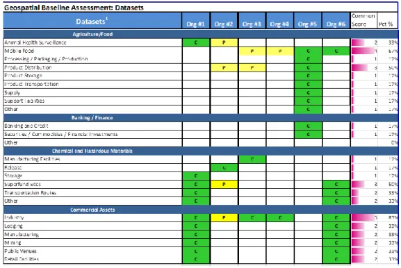
3.4 Geospatial Baseline Assessment Matrix ... 29
3.5 Stakeholder Performance Guide: Business ... 33
4
DATA REFERENCE MODEL ... 34
4.1 Introduction ... 34
4.2 Data Reference Model Approach ... 34
4.4 Data Reference Model Alignment ... 37
4.4.1 Data Description ... 38
4.4.2 Data Context ... 43
4.4.2.1 Data Search and Discovery ... 45
4.4.3 Data Sharing ... 45
4.5 Data Access and Policy ... 45
4.6 Data Resources ... 47
4.6.1 Geospatial Platform ... 47
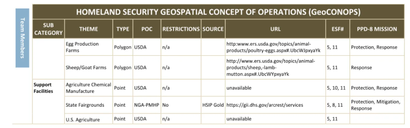
4.6.2 Geospatial Concept of Operations ... 48
4.6.3 National States Geographic Information Council GIS Inventory ... 52
4.7 Stakeholder Performance Guidance: Data ... 53
5
APPLICATION/SERVICE REFERENCE MODEL... 53
5.1 Introduction ... 53
5.2 Application/Service Reference Model(s): Approach ... 54
5.3 Geospatial Services Taxonomy Structures ... 54
5.3.1 Federal Enterprise Architecture Framework, Version 2.0 ... 55
5.3.2 Geospatial Profile of the Federal Enterprise Architecture Framework, Version 2.0 ... 57
5.3.3 Segment Architecture Analysis of the Geospatial Platform, Version 1.0 ... 58
5.3.4 Open Geospatial Consortium: OpenGIS Service Architecture... 62
5.3.5 Spatial Data Infrastructure: Cookbook ... 63
5.3.6 Geospatial Taxonomy Considerations ... 66
5.4 Geospatial Baseline Assessment Matrix: Applications and Services ... 66
5.5 Geospatial Applications/Services Catalogs ... 69
5.5.1 Geospatial Platform ... 70
5.5.2 GEOINT App Store ... 74
5.5.3 Enterprise Registry and Repository ... 73
5.6 Geospatial Shared Services Strategy ... 75
5.6.1 Shared Services Implementation Step-wise Process ... 76
5.7 Stakeholder Performance Guidance ... 76
6
INFRASTRUCTURE REFERENCE MODEL ... 81
6.1 Introduction ... 81
6.2 Alignment to the Enterprise Architecture Investment Planning Process ... 81
6.3 Geospatial Baseline Assessment Matrix: Infrastructure and Technology ... 82
6.4 Digital Government Strategy Alignment ... 82
6.5 Geospatial 3-Tier Target Architecture ... 84
6.5.1 Presentation Layer ... 85
6.5.2 Platform/Application Layer ... 85
6.5.3 Information/Database Layer ... 85
6.6 Geospatial Target Architecture Artifacts ... 86
6.6.1 Unclassified/Public Domain: Geospatial Platform ... 86
6.6.2 For Official Use Only: Geospatial Information Infrastructure ... 89
6.7 Geospatial Target Architecture Considerations ... 91
6.7.1.1 Phase 1 Process ... 93
6.7.1.2 Phase 2 Process ... 93
6.8 Stakeholder Performance Guide: Infrastructure ... 94
7
SECURITY REFERENCE MODEL ... 96
7.1 Introduction ... 96
7.2 Security Principles ... 96
7.3 Stakeholder Roles and Responsibilities ... 98
7.4 Stakeholder Performance Guide: Security and IdAM... 103
8
STANDARDS-BASED INTEROPERABILITY ... 107
8.1 Introduction ... 107
8.2 Standards-based Interoperability: Approach ... 107
8.3 Standards Value Proposition ... 108
8.4 Standards View: Open Standards vs. Open Source ... 110
8.4.1 Open Standards ... 110
8.4.2 Open Source ... 111
8.5 Standards Governance ... 113
8.5.1 Geospatial Standards Development Organizations ... 115
8.6 Standards-based Acquisition Guidance: Reference Sources ... 117
8.6.1 A Geospatial Interoperability Reference Model ... 118
8.6.2 Geospatial Profile of the Federal Enterprise Architecture, Version 2.0 ... 118
8.6.3 Federal Geospatial Architecture Guidance, Version 1.0 ... 119
8.6.4 Federal Geographic Data Committee Endorsed Standards ... 119
8.6.5 Federal Geographic Data Committee Endorsed External Standards ... 119
8.6.6 SDI Cookbook, Global Spatial Data Infrastructure ... 120
8.6.7 GEOINT Standards ... 122
8.6.8 Defense Geospatial Information Working Group (DGIWG) Standards ... 124
8.6.9 Open Geospatial Consortium (OGC) Reference Model ... 125
8.6.10 United Nations Global Geospatial Information Management ... 129
8.7 Stakeholder Performance Guide: Standards ... 130
9
PERFORMANCE REFERENCE MODEL ... 132
9.1 Introduction ... 132
9.2 Applying the Performance Reference Model: Approaches ... 132
9.3 Performance Indices ... 135
9.3.1 Office of Management and Budget: Enterprise Roadmap ... 136
9.3.2 ISE Information Interoperability Framework: Interoperability Maturity Model ... 137
9.3.3 DHS Common Operating Picture: Key Performance Indicators and Measures ... 138
9.3.4 National States Geographic Information Council: Geospatial Maturity Assessment ... 138
9.3.5 Urban and Regional Information Systems Association: GIS Capability Maturity Model ... 139
APPENDIX A: GOVERNANCE ... A-1
A.1 Executive Steering Committee Charter Template ... A-1 A.2 Information Sharing Agreement Checklist ... A-8 A.3 Data Access Request Process – Questionnaire ... A-12 A.4 Standard Template – External Information Sharing ... A-16
APPENDIX B: BUSINESS REFERENCE MODEL ... B-1
B.1 Baseline Geospatial Assessment Matrix: Core Capability ... B-1
APPENDIX C: DATA REFERENCE MODEL ... C-1
C.1 Baseline Geospatial Assessment Matrix: Data Inputs ... C-1 C.2 Baseline Geospatial Assessment Matrix: Datasets ... C-2
APPENDIX D: APPLICATIONS/SERVICES REFERENCE MODEL ... D-1
D.1 Applications and Services Functionality Categories ... D-1 D.2 Functionality of Applications and Services ... D-2
APPENDIX E: INFRASTRUCTURE REFERENCE MODEL ... E-1
E.1 Baseline Geospatial Assessment Matrix: Infrastructure ... E-1 E.2 Baseline Geospatial Assessment Matrix: Technology ... E-2
APPENDIX F: SECURITY REFERENCE MODEL ... F-1
F.1 ICAM Landscape ... F-1
APPENDIX G: PERFORMANCE REFERENCE MODEL ... G-1
G.1 Enterprise Architecture Outcomes and Measurements Template ... G-1 G.2 DHS Common Operating Picture (COP): Performance Management Scorecard ... G-3 G.3 Stakeholder Performance Guide ... G-5
LIST OF FIGURES
Figure 4-1. Data Reference Model Structure ... 37
Figure 4-2. Data Access and Policy Wrapper ... 46
Figure 5-1. IT Shared Services Concept Overview ... 55
Figure 5-2. Federal Enterprise Architecture Framework (FEAF): Application Reference Model ... 56
Figure 5-3. FEAF Application Reference Model: Geospatial Information ... 57
Figure 5-4. Geospatial Services Framework ... 59
Figure 5-5. Uncle Sam’s List ... 69
Figure 5-6. Geospatial Platform: Add Your Tool or Application ... 72
Figure 5-7. Shared Service Implementation Decision ... 76
Figure 6-1. Three-Layers/Tiers of Digital Services ... 84
Figure 6-2. Geospatial Platform Conceptual Model ... 88
Figure 6-3. Geospatial Platform Technical Architecture ... 89
Figure 6-4. DHS Geospatial Information Infrastructure (GII) Technical Architecture ... 90
Figure 6-5. DHS Common Operating Picture Aligned to DHS Geospatial Information Infrastructure ... 91
Figure 7-1. FICAM Conceptual Diagram ... 98
Figure 8-1. GEOINT Standards Pocket Guide ... 124
Figure 8-2. DGWIG and OGC Service Types and Profiles ... 125 Figure F-1. ICAM Components ... F-5
LIST OF TABLES
Table 1-1. What the GIRA Is and Is Not ... 3
Table 1-2. Stakeholder Performance Guide Table Structure ... 8
Table 2-1. Portfolio Management Guidance Principles ... 17
Table 2-2. Standard Acquisition Checklist ... 18
Table 2-3. Types of Agreements ... 22
Table 2-4. Stakeholder Performance Guide: Governance ... 25
Table 3-1. Geospatial Baseline Assessment: Core Mission Services and Stakeholders ... 31
Table 3-2. Geospatial Baseline Assessment: Core Capability ... 32
Table 3-3. Stakeholder Performance Guide: Business ... 33
Table 4-1. Geospatial Baseline Assessment Matrix: Data Inputs ... 36
Table 4-2. Geospatial Baseline Assessment Matrix: Datasets (Extract) ... 36
Table 4-3. Federal Enterprise Architecture Framework V2.0: Data Categorization Methods ... 41
Table 4-4. Standards-based Content Search Methods ... 45
Table 4-5. GeoPlatform Datasets Published per Month ... 48
Table 4-6. GeoCONOPS Authoritative Data Matrix (Extract) ... 49
Table 4-7. Stakeholder Performance Guide: Data ... 53
Table 5-1. Geospatial Profile V2.0: Geospatial Service Components (Extract) ... 58
Table 5-2. Geographic Services Taxonomy ... 64
Table 5-3. OGC® Geospatial Services Taxonomy to ISO 19100 Series Standards Error! Bookmark not defined. Table 5-4. Geospatial Baseline Assessment Matrix: Functionality Categories ... 67
Table 5-5. Geospatial Baseline Assessment Matrix: Applications and Services (Extract) ... 68
Table 5-6. GEOINT App Store Index ... 73
Table 5-7. Stakeholder Performance Guide: Applications/Services ... 78
Table 6-1. Geospatial Baseline Assessment: Infrastructure ... 81
Table 6-2. Geospatial Baseline Assessment: Technology (Extract) ... 82
Table 6-3. Stakeholder Performance Guide: Infrastructure ... 94
Table 7-1. Key Security Activities by SDLC Phase ... 103
Table 7-2. Stakeholder Performance Guide: Security ... 104
Table 8-1. Standards Used in Deployed SDIs ... 121
Table 8-2. SDI Core Standards ... 121
Table 8-3. SDI Supplemental Standards ... 121
Table 8-4. SDI Future Standards ... 122
Table 8-5. Types of GEOINT Standards ... 122
Table 8-6. GEOINT Standards Baseline ... 123
Table 8-7. OGC Document Types ... 128
Table 8-8. Stakeholder Performance Guide: Standards ... 131
Table 9-1. EA Maturity Measurement Template: Areas of Measurement ... 136
Table 9-2. I2F Performance Domain Maturity Model Metrics ... 137
EXECUTIVE SUMMARY
An estimated $20 billion of the Federal Government’s $80 billion in IT spending is a potential target for migration to cloud computing solutions.1 The value of the inherent benefits of cloud
computing is based upon the cost efficiencies of shared services through interoperable architectures based upon standards. IT investment costs decrease as you move from Build to Buy to Leverage/Reuse. A goal of the National Strategy for Information Sharing and Safeguarding is, “to optimize mission effectiveness [to] include shared services, data and network interoperability.”2
Interoperability is a term often used or implied but rarely defined. This document defines information interoperability as:
INTEROPERABILITY is the ability to transfer and use information in a uniform and efficient manner across multiple organizations and information technology
systems.3, 4 It is the ability of two or more systems or components to exchange
information and to use the information that has been exchanged.5
The Geospatial Interoperability Reference Architecture (GIRA) is aligned with current Federal policy, principles, and practices for Enterprise Architecture and further adds to the authoritative body of knowledge of geospatial architecture documentation. It is an unclassified document aimed at an audience consisting of; Executive Leaders, Program Managers, and Solution Architects across Federal, State, Local, Territorial and Tribal governments and private sector stakeholders. It is intended to be a practical roadmap to increase government geospatial information sharing through interoperable capabilities that result in reduced operational costs within and across mission systems. It documents geospatial and architecture policy alignment, references authoritative practices and provides practical guidance including; templates, charters, exchange agreements, baseline requirements matrices, architecture artifacts and tools.
The GIRA is expected to have the following benefits:
• Provide a reference guide for geospatial interoperable architectures to guide solutions to effectively govern, manage, support and achieve information sharing through geospatial system integration, acquisition and/or development.
1
Office of Management and Budget’s (OMB’s) Federal Cloud Computing Strategy, February 8, 2011.
2 White House National Strategy for Information Sharing and Safeguarding, December 2012. 3 Australian Information Interoperability Framework, 2006.
4
U.S. Code, Title 44: Public Printing and Documents (2011) U.S.C. Title 44, Chap. 36, § 3601.
• Provide documented architecture artifacts that can be used to support geospatial program technical oversight and technical assessments for geospatial investments. The GIRA provides a framework for the management, design and development of new or alignment of existing geospatial system/solution investments. It recommends guidance considerations in the areas of governance, business, data, applications/services, infrastructure, standards and security; and performance measures for validating and reporting results.
1 OVERVIEW
1
1.1 PURPOSE
2
The intended purpose of this document is to be a reference guide for geospatial interoperable 3
architecture governance, design and implementation as shared geospatial investments. It 4
supports key stakeholders (e.g., Executive Leadership, Program Managers, and Solution 5
Architects) and their responsibilities associated with geospatial systems implementation, 6
integration and performance to drive interoperability and reduce operational costs as they move 7
toward a shared service environment. 8
1.2 BACKGROUND
9
The GIRA is intended to be a compendium of artifacts to assist in the development of geospatial 10
interoperable reference architecture(s) for enterprise investments. It provides a representation of 11
geospatial systems that is expressed in terms of; governance practices, interoperability 12
requirements, standards, and target implementation examples (e.g. artifacts). The GIRA builds 13
upon and advances the foundational work of geospatial and architecture guidance documents 14
and is complimentary to the Program Manager-Information Sharing Environment (PM-ISE)6
15
Information Interoperability Framework (I2F).7 The December 2005 Presidential Memorandum
16
directed building the ISE upon existing Federal Government resources that include standards, 17
systems, and architectures. The Memorandum included requirements to develop a common
18
framework for the sharing of information between and among executive Departments and 19
Agencies8 and state, local, and Tribal (SLT) governments, law enforcement agencies, and the
20
private sector and define common standards for how information is acquired, accessed, shared 21
and used within the ISE.9 The I2F is intended to drive long-term information sharing requirements
22
that leverage reuse capabilities for improvement and information systems planning, investing, 23
and integration to support the effective conduct of U.S. counterterrorism activities. 24
6 The PM-ISE was established under the authorities of the Intelligence Reform and Terrorism Prevention Act of 2004 (IRTPA), as
amended.
7 Program Manager, Information Sharing Environment Information Interoperability Framework (I2F): National Security Through Responsible Information Sharing, Version 0.5, March, 2014, available at http://ise.gov/ise-information-interoperability-framework.
8 This document’s use of the term “Departments and Agencies” includes Departments, Agencies, Commissions, Bureaus, and Boards
and other types of organizations in the Executive Branch of the U.S. Federal Government.
9 Memorandum for the Heads of Executive Departments and Agencies: Guidelines and Requirements in Support of the Information
Sharing Environment (White House: Washington, DC, 2005), Section 1, available at http://www.whitehouse.gov/news/releases/2005/12/20051216-10.html
1.3 GOALS AND OBJECTIVES
1
The GIRA is intended to define a governance and oversight framework with which Executive 2
Leadership will manage program and acquisition decisions and provide references to key 3
geospatial technical architectures established across government. The GIRA is focused upon: 4
• Stakeholder community: Aimed at Executive Leadership, Program Managers and 5
Solution Architects, the GIRA provides actionable guidance to these key 6
stakeholders in a general-to-specific manner, from providing basic management 7
practices and processes to specific technical services and standards that are critical 8
for geospatial data sharing and interoperability. 9
• Architecture alignment: Applying established architecture frameworks and 10
accepted practices from the Federal community to improve communication by 11
using standardized vocabulary and provide technical architecture descriptions that 12
help simplify complex IT environments. 13
• Practical implementation: Providing target implementation examples, templates, 14
checklists and reference artifacts to aide in making program management, technical 15
and acquisition related decisions. 16
1.4 BENEFITS AND OUTCOMES
17
Desired outcomes of the GIRA are to; 1) increase government geospatial information sharing of 18
interoperable capabilities, 2) promote reuse of existing information assets, and 3) minimize 19
Department and Agency operational costs. To achieve the desired benefit, geospatial system 20
investments must be leveraged as shared services by providing access to common capabilities 21
(applications/services), and increased system integrations by establishing a technology platform 22
that is services based. 23
The GIRA is expected to: 24
• Define governance oversight practices and considerations to ensure collaboration 25
and consensus to meet mission objectives and drive cost efficiencies. 26
• Serve as a base-line target reference guide and resource to identify the necessary 27
interoperability requirements within each of the key architecture elements (e.g., 28
data, applications/services, infrastructure, security, standards and performance). 29
• Provide target implementation examples, artifacts, interoperability standards, 30
engineering designs, contract and procurement language, performance measures 31
and procedural guidance. 32
• Align and conform to the Federal Enterprise Architecture Framework (FEAF) v2, and 33
The Common Approach to Federal Enterprise Architecture, Global Reference 34
Architecture, Unified Architecture Framework, and notional aspects of the 35
Intelligence Community architecture designs. 36
Each Chapter focuses uponthose geospatial interoperability elements required for consideration 1
for that portion of the Reference Model. The document does not attempt to provide a complete 2
geospatial architecture reference implementation or duplicate other authoritative reference 3
material. Table 1-1 describes what the GIRA is and is not. 4
Table 1-1. What the GIRA Is and Is Not
5
GIRA IS: GIRA IS NOT:
A descriptive, not prescriptive, guide to geospatial interoperability investment considerations
A reference for framing a governance structure for geospatial investment coordination and collaboration
A reference for preparing and performing a common baseline assessment (As-Is) of geospatial capabilities and requirements across investments
A means to compare geospatial investments among and between agencies in order to exchange, reuse, and share investments
A reference for comparing several target implementation geospatial architectures and artifacts
A reference for supporting planning and procurement activities for geospatial investments
A reference supporting Office of Management and Budget (OMB) reporting activities, such as Enterprise Architecture (EA) maturity model and Roadmap
A snapshot compilation reference guide that builds upon previous authoritative documentation; but intended to be on on-line collaborative resource in the future
•A “how to” manual for building and maintaining geospatial architectures
•A government-wide all inclusive conceptual or physical geospatial model
•A replacement of existing geospatial architecture structures within the agencies
•An endorsement of any referenced document, organization, process, product, service or capability other than those required by government policy
1.5 STAKEHOLDER AUDIENCE
6
The GIRA is designed as an instructive guide for the three primary stakeholders; Executive 7
Leadership, Program Managers, and Solution Architects. It provides a practical approach for the 8
responsible governance, assessment, design/development, and implementation of interoperable 9
geospatial investments. These three stakeholders form an interdependent role-based 10
responsibility that must be sustained in order to achieve the intended mission benefit: 11
• Executive Leadership: is the responsible authority for the Department or Agency’s 12
policy, fiscal and human resource requirements for geospatial investments. This 13
stakeholder group will use the GIRA as the framework in which geospatial systems 14
are governed, reviewed, resourced, shared, and collectively managed across an 15
enterprise consisting of other geospatial investments. 16
• Program Managers: are responsible for the operational implementation and 17
oversight of geospatial capabilities to ensure they meet the functional mission 18
requirements defined by the intended users. They must communicate to both the 19
Executive Leadership and Solutions Architects to ensure understanding and 20
expectations of the requirements for interoperable geospatial systems investments. 21
Managers are required to quantify the benefit and resource impacts, both cost and 1
integration savings, to Executive Leadership to ensure continued support, and 2
resource sustainment. The GIRA provides Program Managers with a description of 3
the key capabilities, processes, services, infrastructure, standards, performance 4
measures, and artifacts that are required of an interoperable geospatial 5
architecture solution. 6
• Solution Architects: are responsible for acquisition requirements, 7
design/development and the integration of geospatial solutions in accordance with 8
their respective organization’s enterprise architecture technical and management 9
requirements. The Solution Architects will be required to compare and quantify the 10
technical implementation options, alternatives, and cost constraints to the Program 11
Managers. The GIRA provides structured technical guidance and reference artifacts 12
to assist in achieving geospatial system interoperability. 13
1.6 DOCUMENT APPROACH: HOW TO USE
14
The GIRA) is designed as an instructive guide and practical approach for the responsible 15
assessment, design/development, and implementation of an interoperable geospatial investment. 16
The GIRA is organized, in part, to align with the Federal Enterprise Architecture Frameworkv2’s 17
Consolidated Reference Model (CRM). The CRM is the core of the FEAF v2, “…which equips OMB 18
and Federal agencies with a common language and framework to describe and analyze 19
investments.” The CRM consists of a set of interrelated “reference models” designed to facilitate 20
cross-agency analysis and collaboration in a common and consistent way. The six reference 21
models in the CRM to be used within the GIRA include: Business, Data, Applications, 22
Infrastructure, Security, and Performance. The GIRA will also include a section on Open Standards 23
to promote interoperability. 24
By aligning with these FEAF v2’s CRM structure, the GIRA provides a framework for cross-25
community communication, collaboration, requirements collection, resource alignment, and 26
stakeholder buy-in for geospatial investments. 27
Each reference model Chapter of the GIRA is introduced with a description of the 28
‘What/Why/Who/How,’ along with a Stakeholder Performance Guide that frames the 29
requirements, responsibilities, and key questions/issues that each stakeholder must address to 30
achieve an efficient and effective interoperable geospatial investment: 31
• Definition/Description (What) – introduces the intent of the section and the 32
expected results that the stakeholders should derive. 33
• Purpose/Function (Why) – defines the section’s content and its consideration 34
within the geospatial system investment. 35
• Stakeholder Performance Guide (Who & How) – provides a practical question, task 1
or action, from the stakeholder perspective (e.g., Executive, Program Manager 2
and/or Solution Architect), that is critical for an effective and efficient system 3
investment. 4
1.7 AUTHORITATIVE REFERENCING
5
Over 25 years ago, the Federal Interagency Coordinating Committee on Digital Cartography (the 6
forerunner to the Federal Geographic Data Committee) prepared guidance for evaluating and 7
selecting a Geographic Information System: 8
This document has been prepared to assist Federal managers and technical
9
specialists in evaluating, designing, and procuring geographic information
10
systems (GIS’s). Successful GIS implementation and application requires agency
11
personnel to be cognizant of the capabilities and limitations of GIS technology
12
and to carefully evaluate the needs of system users and applications. The variety
13
of possible Federal GIS applications and users make it impractical and
14
inappropriate to provide strict criteria for GIS implementation. However, this
15
document provides general guidance for understanding the technology in a
16
realistic perspective, evaluating the requirements of possible GIS users and
17
applications, identifying applicable standards for information systems
18
technology, selecting desirable software and hardware characteristics, and
19
conducting benchmark tests to identify optimal hardware and software
20
systems.10
21
The GIRA builds upon this basic premise and advances the foundational work of several 22
subsequent geospatial and architectural guidance initiatives. The GIRA provides geospatial and 23
architectural guidance and directs the reader to other key foundational materials that further 24
geospatial system interoperability. 25
1.7.1 GEOSPATIAL
26
• A Geospatial Interoperability Reference Model (GIRM), Version 1.1, December 2003. 27
Federal Geographic Data Committee, Geospatial Applications, and Interoperability (GAI) 28
Working Group. (http://www.fgdc.gov/standards/organization/GIRM) 29
10 A Process for Evaluating Geographic Information Systems. USGS Open File Report, 1988. 88-105, 1998,
Purpose: “This document references standards and specifications needed for 1
interoperability among distributed geospatial services accessible over the Internet.”11
2
• Geospatial Profile of the Federal Enterprise Architecture (FEA), Version 2.0, March 06, 3
2009. Architecture and Infrastructure Committee, Federal Chief Information Officers 4
Council and Federal Geographic Data Committee. (http://www.fgdc.gov/geospatial-lob) 5
Purpose: “The Geospatial Profile is an educational resource for determining how and 6
where geospatial approaches and associated geospatial resources fit into enterprise 7
architectures.”12
8
A Segment Architecture Analysis of the Geospatial Platform,Version 1.0, December 21, 9
2010. Federal Geographic Data Committee, in support of the Federal Chief Information 10
Officers Council. ( http://www.fgdc.gov/geospatial-lob/draft-segment-architecture-11
review/Segment-Architecture-Analysis-of-the/view) 12
Purpose: “The guidance offers strategies for establishing goals, target designs, 13
implementation guidance, and utilization of shared resources and for re-useable, and 14
standards based capabilities.”13
15
• SDI Cookbook, Global Spatial Data Infrastructure, GSDIWiki, last modified June 5, 2014. 16
As a part of its role in the Global Spatial Data Infrastructure (GSDI) Association, the FGDC 17
was the principal developer of the first edition of the reference manual on “Developing 18
Spatial Data Infrastructures: The SDI Cookbook in 2000.” The second edition was 19
subsequently published in 2004 and the current version is part of an active Wiki site: 20
(http://www.gsdidocs.org/GSDIWiki/index.php/Main_Page) 21
Purpose: “…this GSDI Cookbook identifies: existing and emerging standards, open-source 22
and commercial standards-based software solutions, supportive organizational strategies, 23
and policies, and best practices.”14
24
• Homeland Security Geospatial Concept of Operations (GeoCONOPS), Version 6.0, June 25
2014. Department of Homeland Security (https://www.geoplatform.gov/geoconops-home) 26
Purpose: “The Homeland Security GeoCONOPS is intended to identify and align the 27
geospatial resources that are required to support the National Response Framework, 28
Emergency Support Functions, and supporting federal mission partners all in coordination 29
with Presidential Policy Directive-8 direction.”15
30
11 A Geospatial Interoperability Reference Model (GIRM), Version 1.1, December 2003. 12 Geospatial Profile of the Federal Enterprise Architecture (FEA), Version 2.0, March 06, 2009. 13 A Segment Architecture Analysis of the Geospatial Platform, Version 1.0, December 21, 2010. 14 SDI Cookbook, Global Spatial Data Infrastructure, GSDIWiki, last modified June 5, 2014.
1.7.2 ARCHITECTURE
1
• The Common Approach to Federal Enterprise Architecture, May 2, 2012. 2
“This [document’s] common approach to Federal EA provides principles and standards for 3
how business, information, and technology architectures should be developed across the 4
Federal Government so they can be used consistently at various levels of scope within and 5
between agencies, as well as with external stakeholders.”16
6
• Federal Information Technology Shared Services Strategy, May 2, 2012. 7
“…. provides organizations [Federal Agencies} with policy guidance on the full range and 8
lifecycle of intra- and inter-agency information technology (IT) shared services … this 9
strategy requires agencies to use a shared approach to IT service delivery.”17
10
• Digital Government: Building a 21st Century Platform to Better Serve the American
11
People, May 23, 2012. 12
“The [Digital Government] strategy18 …focusing on the key priority area that requires
13
government-wide action: innovating with less to deliver better digital services. It 14
specifically draws upon the overall approach to increase return on IT investments, reduce 15
waste and duplication, and improve the effectiveness of IT solutions defined in the Federal 16
Shared Services Strategy.” 17
• Federal Enterprise Architecture Framework, Version 2.0, January 29, 2013. 18
“The Federal Enterprise Architecture Framework v219 describes a suite of tools to help
19
government planners implement The Common Approach to Federal Enterprise 20
Architecture.” It contains the Collaborative Planning Methodology and is intended to be 21
the next generation replacement for the Federal Segment Architecture Methodology 22
(FSAM). It can be applied as a full planning and implementation lifecycle for use at all levels 23
of scope defined in The Common Approach to Federal Enterprise Architecture. 24
Federal Shared Services Implementation Guide, April 16, 2013.
25
16 Office of Management and Budget, The Common Approach to Federal Enterprise Architecture, May 12, 2012, available at
http://www.whitehouse.gov/sites/default/files/omb/assets/egov_docs/common_approach_to_federal_ea.pdf
17
Office of Management and Budget, Federal Information Technology Shared Services Strategy, May 2, 2012, available at http://www.whitehouse.gov/sites/default/files/omb/assets/egov_docs/shared_services_strategy.pdf
18 Office of Management and Budget, Digital Government: Building a 21st Century Platform to Better Serve the American People,
May 23, 2012, available at http://www.whitehouse.gov/sites/default/files/omb/egov/digital-government/digital-government-strategy.pdf
19 Office of Management and Budget, Federal Enterprise Architecture Framework, Version 2, January 29, 2013, available at
http://69.89.31.228/~mkerncom/wp-content/uploads/2013/02/Federal-Enterprise-Architecture-Framework-v2-as-of-Jan-29-2013.pdf
“The Federal Shared Services Guide20 provides information and guidance on the
1
provisioning and consumption of shared services in the U.S. Federal Government. The 2
guide provides agencies with a high level process and key considerations for defining, 3
establishing, and implementing interagency shared services to help achieve organizational 4
goals, improve performance, increase return on investment, and promote innovation.” 5
6
ISE Information Interoperability Framework (I2F), May 2014.
7
The ISE I2F describes the components that enable information sharing and interoperability 8
within a given reference implementation. The components of the ISE I2F framework allow 9
for practitioners to organize information that defines the scope of what needs to be 10
considered to achieve interoperability between ISE participants. Through the use of this 11
information, ISE participants are able to identify touch points for sharing and safeguarding 12
information in motion; while encouraging the use of interoperability within the scope of 13
enterprise architecture concepts that are, and driven by, an organization’s internal 14
enterprise architecture framework. 15
1.8 STAKEHOLDER PERFORMANCE GUIDE
16
The Stakeholder Performance Guide serves as a quick and concise reference table (see Table 1-2) 17
for the three stakeholders (e.g., Executives, Program Managers, and Solution Architects) and 18
identifies the major steps or decision points that are required for each stakeholder to be 19
successful. The Performance Guide is structured to allow each stakeholder to see their specific 20
area of responsibility based upon an identified task/action requiring their input/decision. It 21
provides a recommended approach to accomplishing the identified tasks expected benefits (e.g., 22
cost, infrastructure, shared services, etc.). The Performance Guide table is one mechanism to 23
verify and measure performance of the investment. 24
Table 1-2. Stakeholder Performance Guide Table Structure
25
STAKEHOLDER PERFORMANCE GUIDE CHAPTER 2 – GOVERNANCE
Role Responsibility Approach Benefit
Exe cu tiv e Le ade rsh ip •Identify specific actions to be taken
•Identify the major tasks requiring go/no-go decisions
•Define what step(s) the Exec needs to take/support to accomplish the specified action
•Identify dependency of tasks and necessary steps
•Define the benefit in terms of quantifiable measures and expected outcomes (mission and resource impact)
•Define the negative impact if not accomplished in terms of mission and resource impact
20 Federal CIO Council, Federal Shared Services Implementation Guide, April 16, 2013, available at
STAKEHOLDER PERFORMANCE GUIDE CHAPTER 2 – GOVERNANCE
Role Responsibility Approach Benefit
Program Manage
r
•Identify specific actions to be taken
•Identify the major tasks requiring go/no-go decisions
•Define what step(s) the PM needs to take/support to accomplish the specified action
•Identify how the PM supports the other two stakeholders (Executive and/or Solution Architect) in the approach
•Identify shared benefit/responsibility if cross agency (if applicable)
Sol u ti on Arch ite ct •Identify specific actions to be taken
•Identify the major tasks requiring go/no-go decisions
•Define what step(s) the SA needs to take/support to accomplish the specified action
•Identify how the SA supports the other two stakeholders (Executive and/or Program Manager) in the approach
•Quantify cost avoidance, services shared, and/or technical integration/ consolidation
1 2
2 GOVERNANCE
1
2.1 INTRODUCTION
2
Definition/Description (What) – Governance is a strategic decision-making process that grants 3
authority, assigns accountability, defines expectations, and verifies performance. It also 4
determines organizational objectives and monitors performance to ensure those objectives are 5
attained.21
6
Purpose/Function (Why) – Provides a formal collaboration and consensus process for shared 7
responsibilities (e.g., Executive Leadership) that drives economies of scale by identifying, 8
prioritizing, and reusing investments to avoid duplicative costs. This chapter will describe how to: 9
• Establish collaborative governance and management oversight body for investment 10
planning. 11
• Establish an Investment Technology Acquisition Review (ITAR) framework and 12
checklist for portfolio management. 13
• Describe how to align to the Capital Planning Investment Control (CPIC) acquisition 14
process. 15
• Provide information sharing agreement guidance for Service Level Agreements. 16
Stakeholder Performance Guide (Who & How) – For Executive Leadership and to a lesser degree 17
Program Managers responsible for policy compliance, resource planning and approval (e.g., fiscal 18
and human), and whom have “signature authority” to commit to program strategic direction and 19
resourcing. 20
2.2 GOVERNANCE PRINCIPLES
21
The ability to coordinate across mission areas and collaborate on geospatial investments is a 22
primary responsibility for the Executive Leadership to drive interoperability and cost efficiencies. 23
When a governance structure is executed effectively, it provides procedures for collaboration and 24
consensus-based strategic decision-making, defines accountability, sets obtainable goals and 25
requirements, shares resource investments, validates accomplishments, and provides measurable 26
performance metrics. Effective governance structures will enable agencies to offer and reuse 27
capabilities and services for sharing across the environment, consistent with an interoperable 28
architecture approach. 29
Without a consensus-based governance structure, achieving interoperability and
1
the maximum value from enterprise geospatial shared service investments is
2
impossible.
3
While a “one-size-fits-all” governance model is not practical there are some common principles 4
for successful governance: 5
• Executive Leadership sponsorship, decision-making authority, commitment, and 6
participation. 7
• Defined roles and responsibilities with accountability by all members, usually 8
through a Charter. 9
• Defined goals and objectives with quantifiable performance measures to 10
demonstrate success. 11
• A systematic and repeatable approach for assessing investments and making 12
decisions. 13
• Subject matter expertise either resident or available through reach-back. 14
• Inclusive discussions with consensus-based collaboration from all members. 15
2.3 GOVERNANCE STRUCTURES
16
There are numerous governance models that can be applied at varying levels of rigor depending 17
upon an organization’s complexity and/or the number and level of geospatial investments that 18
require coordination. The following two examples can be modified or combined to meet the 19
specific needs of the organization and its members. While there is no “one-way” to establish a 20
governance structure; there is “no-way” to succeed without one. 21
Geospatial programs may exist in multiple forms, and may in some cases be
22
distributed throughout an agency without definable governance. In such cases it
23
will be difficult to provide useful indicators of program performance in any
24
measurement area, especially for customer results.22
25
2.3.1 EXECUTIVE STEERING COMMITTEE
26
An Executive Steering Committee (ESC) structure should be established within and across an 27
organization’s enterprise based upon the needs of the organizations (e.g. Office, Branch, 28
Department, etc.) to be included in the committee. There is policy guidance for cross 29
governmental (e.g., Federal and non-Federal involvement including the public) interaction and 30
22 Geospatial Profile, Version 1.1, January 27, 2006. Architecture and Infrastructure Committee, Federal Chief Information Officers
coordination activities as defined by the Federal Advisory Committee Act (FACA). FACA became 1
law in 1972 and is the legal foundation defining how federal advisory committees operate. The 2
law has special emphasis on open meetings, chartering, public involvement, and reporting.23 In
3
terms of Federal agency committees, both intra- and inter-agency coordination, committee 4
structures and operating procedures are based upon consensus-based collaboration, usually with 5
express language stating that the results or findings do not interfere with agency or governmental 6
policy or law. 7
Numerous definitions exist; however, most steering committees are chartered with senior 8
management leadership, are business-oriented and influence/direct resource investment. 9
Merriam-Webster defines a managing or directing committee (e.g., Steering
10
Committee) as “a committee that determines the order in which business will be
11
taken up in a United States legislative body.”24
12
BusinessDirectory.com defines an advisory committee: “… usually made up of
13
high level stakeholders and/or experts who provide guidance on key issues such
14
as company policy and objectives, budgetary control, marketing strategy,
15
resource allocation, and decisions involving large expenditures.”25
16
Some organizations may have prescriptive requirements for the establishment of ESCs through 17
their Office of General Council or related policy or legislative affairs offices depending upon the 18
proposed membership of the committee (e.g., internal or external). Once policy guidance is 19
determined, the structuring of the ESC can occur. As the name implies, an ESC is sponsored and 20
lead by a decision-making level body of representatives, (see Section 1.5 Stakeholder Audience, 21
for the definition of Executive Leadership). The sponsoring body, office or board often chairs/co-22
chairs the committee; however, member roles and responsibilities are defined by a Charter (see 23
Appendix A) as part of the collaborative and consensus-based approach. 24
2.3.2 INTEGRATED PRODUCT/PROJECT TEAM
25
In 1995, the Secretary of Defense directed that the Department adopt Integrated Product/Project 26
Teams (IPTs) as the preferred approach for development, review, and oversight of the acquisition 27
process.26 An IPT process, while generally designed for an engineering approach to a system or
28
“product,” it can also be applied to the governance of developing an interoperable geospatial 29
investment either as a standalone approach or as part of the Executive Steering Committee 30 23 http://www.gsa.gov/portal/content/100916 24 http://www.merriam-webster.com/dictionary/steering%20committee 25 http://www.businessdictionary.com/definition/steering-committee.html
structure described above. Generally, the “P” in IPT stands for product; however, it is also 1
appropriate for project as defined below: 2
The Defense University, defines an Integrated Product Team as “a
3
multidisciplinary group of people who are collectively responsible for delivering a
4
defined product or process.”27
5
The IT Law Wiki defines an Integrated Project Team as “composed of
6
representatives from all appropriate functional disciplines working together with
7
a Team Leader to build successful and balanced program, identify and resolve
8
issues, and make sound and timely recommendations to facilitate
decision-9
making.”28
10
IPTs are used in complex development programs/projects for review and decision making. The 11
emphasis of the IPT is on involvement of all stakeholders in a collaborative forum. IPTs are 12
created most often as part of structured systems engineering methodologies, focusing attention 13
on understanding the needs and desires of each stakeholder. The IPT approach simultaneously 14
takes advantage of all members’ expertise and produces an acceptable product the first time. 15
Several more detailed resources are available for users to assess IPT processes and procedures to 16
determine if the structure can be adopted/adapted for use in their geospatial governance. These 17
documents have detailed operating principles and practices and provide example artifacts for the 18
use to apply to meet their needs. 19
• Rules of the Road: A Guide For Leading Successful Integrated Product Teams,
20
Revision 1, October 1999, Department of Defense29
21
• Integrated Project Team (IPT) Start-up Guide, February 2009, MITRE30
22
The following summarizes many of the practices and procedures of the authoritative sources 23
listed above. IPTs, in general, will require operating principles and practices to include: 24
1. Chartering and Authorizing – requires the overall sponsorship and membership of the 25
governing body within the existing policy and protocol structure of the organization. This 26
may be prescribed by law, statute or other established agency specific policy and 27
guidance. If no authorizing structure exists, the Charter sponsorship and membership 28
agreement must be defined in the Charter which also defines the roles, responsibilities 29
and decision-making process. 30 27 https://acc.dau.mil/CommunityBrowser.aspx?id=24675 28 http://itlaw.wikia.com/wiki/Integrated_Project_Team#cite_note-0 29 http://www.navair.navy.mil/nawctsd/Resources/Library/Acqguide/IPT%20Rules%20of%20the%20Road.htm 30 http://www.mitre.org/publications/technical-papers/integrated-project-team-ipt-startup-guide
2. Goal Alignment – to ensure an agreed upon, mutually beneficial set of objectives that are 1
quantifiable to all members. 2
3. Open Discussions with No Secrets – is the basis for mutual trust and collaboration. It is 3
also a mechanism to ensure both leadership and individual members do not unduly 4
influence the overall direction of the team. 5
4. Empowered, Qualified Team Members – ensures the best resources are applied to 6
address the issue. This can also require ‘reach-back’ to subject matter experts for a 7
limited duration to address a specific issue. 8
5. Dedicated/Committed Proactive Participation – ensures a collaborative and informed 9
working environment without revisiting issues and unnecessary delays. The level of 10
participation must be understood and agreed to by the member in advance to set 11
expectations. 12
6. Issues Raised and Resolved Early – pending the structure of the IPT, issues should be 13
resolved with an inclusive approach. If issues cannot be resolved, there needs to be an 14
escalation and resolution process to Executive Leadership for closure and advancement. 15
IPTs can be very involved requiring defined requirements, process, documentation, measures, and 16
accountability. The need for a disciplined approach includes core tenants: 17
1. Understanding the requirements – an opportunity is identified that requires IPT 18
resolution or assistance. This could be as broad as developing an interoperable enterprise 19
geospatial capability or as limited as determining which organization within an enterprise 20
will be the steward for an enterprise geospatial capability. 21
2. Outlining the approach – framing the goal and objectives with roles and responsibilities 22
(and memorialized through a Charter) with clear outcome expectations is defined. 23
3. Planning the effort – working as an IPT, team members develop a Plan Of Action & 24
Milestones (POA&M) to fully develop detailed tasking and levels of efforts estimates to 25
allow the appropriate allocation of resources. 26
4. Allocating resources – key stakeholders are identified and the team members are 27
launched by senior leadership to resolve the opportunity at hand. Leveraging financial 28
resources will be determined by the Executive Leadership. 29
5. Executing and tracking the plan – project management skills are essential along with the 30
subject matter expertise to execute the defined tasks. Reporting based upon the POA&M 31
schedule (scope, schedule, and budget) and the ability to address issues that will arise 32
during the project period. Most issues should be discussed and resolved within the IPT 33
environment. When issues cannot be resolved, problems are escalated to Executive 34
Leadership intervention. 35
6. Delivery – as issues are resolved and the POA&M executed, the IPT completes and 1
delivers its Chartered outcome requirements. 2
7. Reevaluation – upon delivery and review with Executive Leadership, the IPT provides 3
necessary feedback to IPT membership and evaluates the need for continuation of the 4
IPT. 5
8. Finite Duration – if requirements are fulfilled the IPT is disbanded. 6
The governance of geospatial investments should be crafted based upon the complexity of the 7
organization(s) involved, number and level of investments, and the agreed upon value to the 8
mission/business. 9
2.4 INVESTMENT GOVERNANCE
10
Governance of geospatial investments can be viewed as operating at three different levels of an 11
organization: Program, Portfolio and Enterprise. An integrated, multi-tiered governance 12
framework unites disparate processes to eliminate redundant and low-value investments.31
13
• Program – program-level success is defined by meeting the goal of delivering a 14
system that meets specified, contracted-for performance, price, and schedule 15
parameters. Program-level decisions, directions, and actions align with that view of 16
success and influence the expectations of systems engineering provided at that 17
level. 18
• Portfolio – the focus shifts to making trades among a collection of programs to 19
achieve capability-level outcomes. The tradeoffs balance various criteria, including 20
the importance of capabilities to be delivered and expected delivery schedule 21
within constraints, such as availability of funding and dates operational capabilities 22
are needed. Portfolio-level decisions can result in programs being added and 23
accelerated, cut back and decelerated, deferred, or cancelled. 24
• Enterprise – result in change of environment or rules in which programs and 25
portfolios operate including their roles and responsibilities to achieve enterprise-26
wide outcomes, such as joint interoperability or net-centricity. Often, this is 27
achieved through departmental or agency-wide policies and regulations.32
28
As organizations mature from Program to Portfolio to Enterprise levels, greater technical 29
documentation should be developed and maintained to allow each pending new investment to be 30
assessed, aligned, and adopted. The increase in the number of investments makes the complexity 31
31 Ensuring IT Investments Deliver Their Promised Value, The Importance of Enterprise Governance, January, 2011, Office of the Chief
Information Officer, DHS.
32 Department of Homeland Security, Systems Engineering and Acquisition, Best Practices: A Portal Companion, Version 1.0,
and challenge greater but also more important. At the individual Program level, the acquisition 1
process may only use the existing Procurement Office procedures required of all investments 2
within an organization. At the Portfolio level, a baseline assessment (e.g., As-Is environment) is 3
essential to allow Senior Leadership the ability to make strategic investment, Program Managers 4
to coordinate and allocate human resource coordination across individual programs, and Solution 5
Architects the ability to design and develop interoperable components at the application and 6
system level. The baseline assessment or As-Is (e.g., GeoBaseline) documentation (see Section 3.4 7
and Appendices B, C and D) provides the foundation to perform these tasks and the basis upon 8
which to achieve enterprise-wide outcomes. 9
A mature enterprise may strive to establish and sustain a Technical Reference Model (TRM) or 10
Target Architecture of the desired technical framework to which investments should align. The 11
TRM is a component-driven, technical framework categorizing the standards and technologies to 12
support and enable the delivery of services and capabilities. It provides a foundation to advance 13
the reuse and standardization of technology and Service Components from a government-wide 14
perspective.33
15
Aligning agency capital investments to the TRM leverages a common, standardized vocabulary, 16
allowing intra/interagency discovery, collaboration, and interoperability. Agencies and the federal 17
government will benefit from economies of scale by identifying and reusing the best solutions and 18
technologies to support their business functions, mission, and target architecture. Organized in a 19
hierarchy, the TRM categorizes the standards and technologies that collectively support the 20
secure delivery, exchange, and construction of business and application services and capabilities 21
that may be leveraged in a component-based or service-oriented architecture. 22
The TRM or Target Architecture would list the types of technology an organization would use and 23
may include categories of use to include:34
24
• Permitted – products and standards that currently reside in the TRM and approved 25
for use. 26
• Go-To (Target) – products and standards that the Department/Agency is migrating 27
towards and considered enterprise-wide solution, and have a compliance date for 28
usage. 29
• Divest – products and standards which are obsolete and the Department/Agency
30
must actively plan for disposal and should not invest further, with a specified 31
divestment date. 32
33 Office of Management and Budget, FEA Consolidated Reference Model Document, Version 2.3, October 2007.
34 Department of Homeland Security, Information Technology Acquisition Review (ITAR) Quick Essentials Guide, Version 3.0,
• Restricted – products and standards that can only be used by the organization 1
obtaining approval. 2
• Emerging – products and standards that will be utilized in a very limited capacity 3
during the prototypes or pilot phase of a program development with future 4
decision pending approval. 5
• Prohibited – products and standards that are not aligned to the Department/Agency
6
TRM and may not be procured. 7
Once a TRM or Target is established, a pending geospatial investment can then be compared 8
against both the As-Is GeoBaseline and TRM and reviewed by the governance body to ensure 9
existing capabilities are reused and new capabilities can be shared across the enterprise. 10
2.4.1 INFORMATION TECHNOLOGY ACQUISITION
11
REVIEW PROCESS
12
A primary benefit of governance is the efficient and agreed upon use of geospatial resource 13
investments. As part of the governance structure, an investment review process should be 14
established to ensure the optimal reuse of existing capabilities and the effective development of 15
new shared capabilities across the enterprise. While the geospatial governance body does not 16
[necessarily] have “veto” authority, as each organization will have its own procurement approval 17
procedures and signatory authorities (e.g., CIO or CFO), it does provide the ability to align 18
investments and reduce duplication for maximum interoperability. 19
The governance body should establish portfolio management guidance to pending investments 20
and help prepare for the Information Technology Acquisition Review (ITAR). Table 2.1 provides 21
portfolio management guidance principles to ensure:35
22
Table 2-1. Portfolio Management Guidance Principles
23
PORTFOLIO MANAGEMENT GUIDANCE PRINCIPLES
•The program requirements are completely clear in meaning or intention, correct, and complete.
•Acquisition requirements align with established portfolio targets and transition plans.
•New acquisitions support a capability gap existing within a portfolio.
•If the acquisition provides services to other investments within the Department/Agency, the performance requirements are defined (e.g., Service Level Agreement (SLA) or Memorandum).
•Any other capability/service in the Department/Agency portfolio (existing or planned), as identified in the GeoBaseline or TRM, is identified. Acquisition requirements should not overlap and the investments should determine the most effective solution for the Program and Enterprise.
•Opportunities to consolidate all or part of the acquisition with other existing/planned acquisitions
35 Department of Homeland Security, Information Technology Acquisition Review (ITAR) Quick Essentials Guide, Version 3.0,
PORTFOLIO MANAGEMENT GUIDANCE PRINCIPLES
within the Portfolio have been examined and resolved.
•If necessary, contractual or policy language must be developed to mandate portfolio alignment.
The governance body should define the required documentation for an investment review. A 1
pending investment review submission package should include:36
2
• A Standard Acquisition Check list (see Table 2-2). 3
• Acquisition Documentation (i.e., Statement of Work (SOW), Statement of 4
Objectives (SOO), Performance Work Statement (PWS), Request for Proposal (RFP), 5
or other supporting documents). 6
• Independent Government Cost Estimate (IGCE) or Bill of Materials (BOM). 7
• Signed memorandum or other indication of Senior Leadership approval. 8
A Standard Acquisition Checklist for effective portfolio management should consist of the 9
following: 10
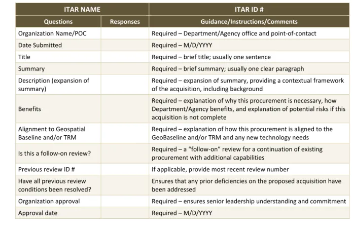
Table 2-2. Standard Acquisition Checklist37
11
ITAR NAME ITAR ID #
Questions Responses Guidance/Instructions/Comments Organization Name/POC Required – Department/Agency office and point-of-contact
Date Submitted Required – M/D/YYYY
Title Required – brief title; usually one sentence
Summary Required – brief summary; usually one clear paragraph Description (expansion of
summary)
Required – expansion of summary, providing a contextual framework of the acquisition, including background
Benefits
Required – explanation of why this procurement is necessary, how Department/Agency benefits, and explanation of potential risks if this acquisition is not complete
Alignment to Geospatial Baseline and/or TRM
Required – explanation of how this procurement is aligned to the GeoBaseline and/or TRM and any new technology needs Is this a follow-on review? Required – a “follow-on” review for a continuation of existing
procurement with additional capabilities Previous review ID # If applicable, provide most recent review number Have all previous review
conditions been resolved?
Ensures that any prior deficiencies on the proposed acquisition have been addressed
Organization approval Required – ensures senior leadership understanding and commitment
Approval date Required – M/D/YYYY
36 Ibid.
37 Department of Homeland Security, Information Technology Acquisition Review (ITAR) Quick Essentials Guide, Version 3.0,