GALLINAZO PHASE MIGRATIONIN THE MOCHE VALLEY, PERU
Barker Fariss
A dissertation submitted to the faculty of the University of North Carolina at Chapel Hill in partial fulfillment of the requirements for the degree of PhD in the Department of
Anthropology (Archaeology).
Chapel Hill 2012
Approved by: Dr. Brian R. Billman
Dr. Carole L. Crumley
Dr. Scott L. H. Madry
Dr. R. P. Stephen Davis
iii
ABSTRACT
BARKER FARISS: Gallinazo Phase Migration in the Moche Valley, Peru (Under the direction of Brian R. Billman)
iv
v
ACKNOWLEDGEMENTS
There are so many people I must recognize as instrumental in completion of my project. Without a doubt, I would not be here if it were not for the encouragement of Brian Billman, my dissertation advisor, colleague and friend. I would also like to thank everyone in my dissertation committee individually. Carole Crumley has been a mentor to me since my years as an undergraduate student at UNC in the 1990’s. I always sought her approval and she
helped me achieve a confidence in my ability that I will carry forward into my professional career. Scott Madry’s assistance with GIS has been invaluable; and, his behind-the-scenes
supervision of my project helped me find a path to completion. Steve Davis and Patricia McAnany provided me with some of the most thorough and insightful comments regarding the presentation of my research. My dissertation in its current form is in large part a result of the time and effort they put into thoughtfully reading multiple drafts of the manuscript. Thank you all very much.
vi
While I know you are too young to realize it now, Keller and Crosby, your presence in my life has inspired me to fight through disappointment and misfortune, and to continue working on this project even when it seemed hopelessly out of reach. To my mom, Dolores, you very much continue to be an inspiration to me; and your words of support have been essential every step of the way. To her husband Cecil, thanks for championing my project all these years as a priority, reminding me of its significance in the face of sobering life events. For over a decade, Brandie’s parents Bob and Lisa Sullivan and her sister Jamie have maintained unwavering support; thank you. To my big sister Kristie, thanks for always being there. Dad, thanks for imparting nuggets of practical wisdom that continue to serve me well; such as, “excuses only sound good to those who make them” (so, let that be fair warning to
my nascent graduate students). To my entire family, thank you so much for all you have done; and, thank you in advance for your patience, love and support in the years to come.
vii
PREFACE
As I write this preface, I have just returned from monitoring a seismographic survey in Oklahoma. I work for the Osage Nation now, and frequently find myself thinking about the role of archaeologists in today’s society. As the wells are drilled and the pipelines are buried, everyone seems concerned about energy independence or environmental degradation; rarely does one hear elected officials or the public discuss protection of cultural resources. But, although few are talking about it, the good thing about the United States is that we have laws to protect cultural resources. What’s more, the great thing about having laws in this country
is that they are usually enforced. I find myself reading dozens of Section 106 notifications every day, monitoring construction in culturally sensitive areas and performing other duties.
viii
I was trained as an Andean archaeologist. This dissertation deals with prehistory on the North Coast of ancient Peru. While Peru has laws regarding the protection of cultural resources, they are almost never enforced. Around the world, in places like the Moche Valley, Peru, it has become the job of research archaeologists (often foreign) to manage the preservation of cultural resources. By saying this, I am not passing judgment; often these countries have far more important social issues to manage with limited financial resources. It seems ironic that many of the most significant prehistoric sites are situated in the poorest regions of the world. It is important for research archaeologists working in these regions to bring with their field school students, grant funding, and professional agendas a plan for preserving the cultural resources in unprotected areas.
ix
I first traveled to Peru in 1997 to attend a three-month Spanish immersion course in Cuzco with my wife Brandie, a new graduate student in the Ecology Curriculum at UNC-Chapel Hill. We returned to Peru every summer over the next three years for her pre-dissertation fieldwork, until we moved to Peru in 2001 to conduct her field research. Brandie’s dissertation focused on community and conservation dynamics in the Huascaran
Biosphere Reserve and World Heritage Site, and for nearly two years we lived in a highland village called Pashpa located just over 10,000 feet above sea level [Figure F-1]. I helped conduct social surveys and followed herders around for weeks in participant observation.
x
Years before moving to Peru, I worked with a linguistic anthropologist on a project with the Cherokee Nation in Tahlequah, Oklahoma and on multiple projects with human geographers and anthropologists at the Carolina Population Center in Chapel Hill, North Carolina. In the years working my way through college, I had multiple forays in and out the food service industry and almost opened a restaurant with a good friend of mine. At the last minute, I got cold feet and returned to anthropology at the Duke Primate Center in the Fossil Primate division. For two years, while at Duke, my interest in anthropology was solidified.
xi
Figure P2. The Refugio is located in the Ishinca Valley, Huascaran Biosphere Reserve.
Every week, I was charged with the task of hiking up to the Refugio, climbing atop the lodge and downloading weather station data. As I sat there that day waiting for the station to dump a week’s worth of wind speed, precipitation and temperature data, I realized that her
project would be coming to an end soon. I peered up at the peaks surrounding me and thought about learning to climb. My mind drifted from the Wichita Mountains in Oklahoma to the ranch in Paul’s Valley where I spent many of my summers as a child. The ranch
xii
actual grandfathers passed away when I was very young. CY was a longhorn steer rancher by trade, but always wanted to be an archaeologist. Before the war, he had participated on excavations in Egypt and other parts of the world as a camp cook; and later in life returned to school to get a Master’s degree in Anthropology, with a concentration in Archaeology.
We would often ride out on the prairie in his old F-150 to search for wayward young bulls, mend fences, drop feed and fill water tanks. Behind the bench seat, he kept a wooden box of prehistoric tools he’d found on his land. There were dozens of scrapers and a few
projectile points. He had a coffee can full of heat-treated pink flakes fashioned from the local Florence-A chert and various other lithic materials. He even had some ceramic sherds, which are a pretty rare find on the ground surface in this part of the country. CY taught me about stratigraphy and seriation, and the law of superposition. He always gave me archaeological or anthropology-related gifts for Christmas and birthdays; such as a book of Catlin’s paintings, or the Marshalltown I still use today. More than any other person, I can
attribute my interest in prehistoric cultures and my early foundations in archaeological method to him.
xiii
archaeological investigations on the North Coast of Peru, the Moche Origins Project (MOP). He suggested I come check it out once we moved to Peru. Then, with a beep, the weather station indicated it was finished uploading the data to my computer. I climbed down off the roof and hiked back to Pashpa.
Later that week, between buying provisions for the month ahead and planning the logistics of upcoming research efforts (not to mention showering and sleeping on an actual bed at a guest house in Huaraz) I found time to visit an internet café near the Plaza de Armas. I sent Brian an email about coming down to the coast and visiting the MOP study site, and asked about possibly staying for a little while. He responded later that week with an enthusiastic welcome and offered me a volunteer staff position on the field school.
About four weeks later, I found myself at the station in Huaraz about to board an overnight bus to Trujillo. I wasn’t sure where the curvy descent from my home in the
mountains would take me, both literally and figuratively. I walked across the platform and my gaze diverted through the gate at Mount Huascaran, the tallest mountain in Peru. It towers above Huaraz at more than 20,000 feet. It is only a few miles from Huaraz, and from just about anywhere in town you are provided with a magnificent view of the peak. I paused before stepping on to the bus as my mind’s eye captured the image of its massive glacier and
xiv
Upon arriving in Trujillo at 5 o’clock in the morning, I was weary and disoriented. It was
dark and cold; but not a dry cold like the mountains, it was dank. The city seemed dingy. The buildings around the bus station looked the same as any other metropolitan area in Peru, cinderblock constructed flats, sandwiched together and stacked one on top of the other with rebar and cemented glass shards sticking out of the walls of the roof. Although I was new to this place, I was not new to this sort of place. I took a minute to gather myself and waited for the sun to rise before I found my way outside to negotiate an overpriced taxi ride to Huanchaco, the location of the MOP field house.
xv
Figure P3. Los caballitos on the beach in Huanchaco.
I recall that a pair of doves cooed from within the dense bush above my head, their song a leggerio against the drone of nearby Pacific waves. Only slightly muffled by the thick wooden door, I could hear Billman’s unmistakable laughter. I knew I had found the right house, but what’s more, I knew I had found the right place. I knocked. Jennifer Ringberg
xvi
exactly why we call that room the maid’s quarters, I guess because it has a small water basin and brooms stored there. Although just big enough for an old worn out mattress thrown on the floor, it was obvious no one had actually lived in the tiny room for a very long time, if ever. Nevertheless, it was available floor space. I graciously nodded and I threw my duffle on the mattress. It landed with a thud and a cloud of dust floated across the beams of early morning sunlight. I turned to notice the view and took note of the pleasantries my rooftop accommodations afforded me. I returned downstairs and grabbed a cup of coffee to go. Before I knew it, we were speeding down the Pan American highway to the Moche Valley.
On route to the site, I got to know some of the crew. Jen, Jesus Briceño (the MOP co-director) and Brian led our car and the bus full of field school students through the Moche Valley to Cerro León. I was introduced to three graduate students at UNC working on the project that summer, Greg, Jon and Drew. Upon arrival, we filed out of the vehicles and chatted about logistics for a minute. We lathered on sunscreen and portioned out the gear for the short, but steep, hike up Cerro León to MV225. At the top, Jon and Greg began stringing out a new unit. Drew found a student volunteer to jockey the stadia rod while he ran the total station. Multiple groups of students gathered around scattered sorting boards, laughing and whispering and shouting all at the same time. Brian conferred with the site guard and local laborers about various things, including payday on Friday. Jen showed me her excavation unit first and I continued to work there with her for the next few days.
xvii
theoretical perspectives on the bigger picture of what we were attempting to do. As a newbie, I spent much of my time on the sorting board, learning the material culture. Then, there was the paperwork, ah … the paperwork. Of course, Jen helped me with that too. I owe her one for introducing me to the MOP and field archaeology in general. Strike that. I owe her at least a case for everything she’s done for me.
After my first week on the project, I knew that archaeology was what I wanted to do professionally. As I mentioned previously, at one time or another, I had worked in every other sub-field of anthropology. I felt like my exposure to so many different perspectives had molded my unique skill set. On my last night in Huanchaco, while on the roof watching the sun sink into the ocean and partaking in an adult beverage, Brian and I discussed graduate school and my future on the project.
xviii
TABLE OF CONTENTS
LIST OF TABLES...xxi
LIST OF FIGURES...xxii
Chapter 1. INTRODUCTION...1
The Spatial Signature of Nonlocal Settlement...8
Research objectives...13
Dissertation Outline...16
2. THE MOCHE VALLEY...17
The Southern Oscillation...20
North Coast Cultural Chronology...28
Initial Period...32
Early Horizon Period...36
Early Intermediate Period...39
Early Intermediate Period: Rise of the Mochica...44
Middle Horizon Period...45
Late Intermediate/Late Horizon Period...46
xix
3. SETTLEMENT ANALYSIS GIS...51
A Brief History of GIS...58
Archaeological Geomatics...61
The Moche Origins Project Geographic Information System (MOP-GIS) ...63
Model Building…...68
Concluding Remarks...71
4. MIGRANT HOUSEHOLDS...73
Cerro León...76
Social Space, Practice and Place...82
Architectural Forms...84
MV64...90
MV151...92
MV170...95
MV267...97
MV345 ...98
MV385...99
MV441...101
MV469...102
MV482...103
Overview of Nonlocal Sites in the Moche Valley...107
Wealth on the Hoof...108
xx
5. GEOSPATIAL MODELING OF A MIGRATORY LANDSCAPE...117
Data Analysis...119
The Slope Model...126
Cumulative Visibility Analysis...132
Modeling Mobility...136
Agro-Ecological Zonation (AEZ)...140
Concluding Remarks...148
6. QUANTIFYING VARIATION WITHIN NONLOCAL COMMUNITIES...151
Data Transformations...158
K-means...159
Ordination...163
Concluding Remarks...172
7. CONCLUSION…...173
Future Directions...178
xxi
LIST OF TABLES Table
1. North Coast Cultural Chronology...30
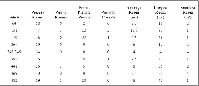
2. Counts and sizes of room types for 9 single-component sample sites...90
3. Nonlocal settlement signature model summary...123
4. Importance of Principal Components...168
xxii
LIST OF FIGURES Figure
P1. Reflection of Huascaran in a tarn near Pashpa... ix P2. Refugio located in the Ishinca Valley,
Huascaran Biosphere Reserve... xi P3. Los caballitos on the beach in Huanchaco... xv 1-1. Map of the Moche River Valley,
on the North Coast of Peru, SA... 2 2-1. View of the middle Moche Valley
from MV225 on Cerro León... 18 2-2. Hillshade 3d relief of the Moche Valley watershed... 19 2-3. El Niño cut is visible in the upper Moche Valley... 23 2-4. Nonlocal and local sherds from storage vessels... 29 2-5. Northern river valleys with ceremonial centers... 33 2-6. Chimú press-mold grey ware... 46 3-1. 3d Model of the Cerro León landform
with MV225 site architecture...67 4-1. Example of highland-style red slip decoration
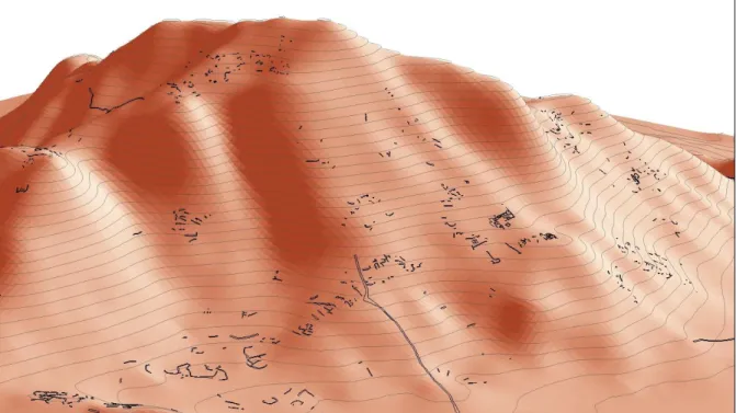
on interior lip of a rim... 75 4-2. Sites at Cerro León...77 4-3. Cerro León with architectural areas... 79 4-4. Examples of Cajamarca Serrano style kaolin vessels... 81 4-5. Nine single-component nonlocal site areas
xxiii
4-8. Broken Donut stone... 91 4-9. Slab and fill masonry wall in photo,
with field map in profile...91 4-10. Stacked stone masonry wall,
photo with field map in profile... 92 4-11. Nonlocal single-component elite cluster... 93 4-12. Planview of MV151... 94 4-13. Example of an excavated slab-lined burial cyst………... 95 4-14. Example of a niche embedded in a wall... 97 4-15. Planview of the upper portion of MV385... 100 4-16. Cluster of very small sites in association with MV469... 102 4-17. Planview of architecture at MV482... 104 4-18. Small room built into the side of the mountain...106 4-19. Area of potential animal enclosures at MV225... 109 4-20. Llamas and alpacas... 110 4-21. Average parts per million (ppm) of Phosphorus
xxiv
5-8. Agro-Ecological Zonation GIS model flowchart... 142 5-9. Primary production zones for coca and maize
in the middle Moche Valley... 144 6-1. IDW of nonlocal settlement autocorrelation... 155 6-2. 3d visualization of the Natural Neighbors interpolation... 157 6-3. Plot of SSE for factor analysis... 161 6-4. Plot of SSE against the random SSE for factor analysis... 162 6-5. PCA with K-means clusters... 167 6-6. Variables factor map with data variance cloud... 170 6-7. 3d scatter plot for Principal
1
CHAPTER 1 INTRODUCTION
A significant issue for archaeology is the development and refinement of approaches for the study of culture change and persistence using material remains. This issue is especially pertinent to archaeologists undertaking culture contact research in pluralistic settings. How does one evaluate the magnitude, direction, and meaning of change that may result from encounters between diverse people in multi-ethnic communities?
(Lightfoot et al. 1998:200)
2
here as tools, methods and theories from spatial sciences used in archaeological settings; the latter is defined here as an inductive process of determining the statistical magnitude of specific variables to calculate the probability of a general outcome.
3
One of the central ideas of my research is that ethnicity is reflected in the formation and maintenance of constructed environments. My hypothesis is that because vast quantities of nonlocal ceramics are prevalent in the Moche Valley only during the Gallinazo Phase of the EIP, if a site was not occupied previously (indicated by local components that predate the Gallinazo Phase), then I assume decisions about settlement location, spatial organization and architectural form were made by nonlocal migrants. As will be discussed later, there are many indications that nonlocal ceramics are highland in origin. I infer that the occupants of sites with nonlocal, presumably highland-style pottery, are also highland. This dissertation provides evidence for this inference and speculates on its implications for understanding culture contact and interaction between coastal and highland groups living in the Moche Valley during the Gallinazo Phase of the EIP.
Understanding diverse settlement decisions helps archaeologists disentangle issues of cultural contact in pluralistic social settings of the past. I use the term ethnicity, but it is burdened with self-referential meanings that are practically indecipherable by the outside analyst. We understand now that ethnic identity is borne out of specific social organization, not the vagueness of culture. Fredrik Barth's (1969) revolutionary conceptualization of ethnicity stresses a fluid, self-ascribed and dynamic identification of group membership. Barth (1969:9) finds “categorical ethnic distinctions do not depend on an absence of mobility, contact and information, but do entail social processes of exclusion and incorporation whereby discrete categories are maintained despite changing participation and membership in the course of individual life histories.” In the same text, he further
4
interpretation of ethnic identity is that it originates from the interplay of inclusion in one group and exclusion from another.
Further describing the breadth and progression of theory concerning the concept of ethnicity is out of the scope of this dissertation (for review, see Barth 1969a, 1969b, 1969c, 1989, 1994; Blu 1980; Boas, F. 1974 [1887] and 1974 [1905]; Brumfiel 1994; Childe 1933; Jones 1997; Lightfoot et al. 1998; Trigger 1989). Siân Jones’s (1997:84) chapter on multidimensional ethnicity was particularly useful for contextualizing an analytical framework for using the concept of ethnicity in my research. However, I use the term ethnicity in this dissertation as a heuristic device to describe two groups of people: a nonlocal population, presumably from the highlands, and a local coastal population. I use two primary sources for my assumptions about nonlocal pottery in the Moche Valley during this time period: Brian Billman’s 1996 dissertation and Jennifer Ringberg’s 2012 dissertation.
5
While I understand that “concepts of ethnicity and identity have replaced the colonial paradigm and propositions of ‘pots as people’ are considered fallacies” (Cruz 2011:336), “they [ceramics] are understood to be products of a particular socio-cultural milieu such that
ceramic variation will correspond with cultural variation at some level” (Croucher 2006:107). In this way, I use ceramic type presence/absence data as a proxy measure for the presence or absence of nonlocal and local decision-makers influencing the materiality of daily life, such as the construction or placement of households.
6
chronology. Excavated contexts from sites in the Moche and other neighboring valleys are used to seriate ceramic styles.
There is some agreement among scholars that the "origin myth" is the strongest bond between members of an ethnic group (see Anderson 1983, 2006; Nash 1996; Smith 1996), an aspect of culture pointed out long ago by Max Weber in his treatise Economy and Society, posthumously published in 1921 (Roth and Wittich 1978). Belief in a common origin is perhaps a prerequisite for defining the traditional “ethnic” group, while other aspects of culture like religion and language, which are important to determining the boundaries between ethnic categories (Jenkins 1994), remain negotiable (Barth 1969; Cornell 1996; and Conversi 1999). If the temporal and spatial dimensions of origin can be considered negotiable variables for ethnic groups, one should consider that the temporal dimension of origin is an abstract concept, while the spatial dimension can be visualized and identified. The spatial dimension of ethnicity is more readily perceived by members of a group.
This perceived spatial connection might be described as an ethnoscape (Appadurai 1996). An ethnoscape can be thought of as the territorialization of ethnic memory; in other words, it is the belief in a common spatial origin shared by members of a group (Smith 2002). The collective understanding of spatial origin allows people to move into other geographic space, but maintain their common ethnic identity. In this way, ethnoscapes produce space (Lefebvre 1991). Yet, social constructs of space and time are vulnerable to reorganization and modification. As landscapes change through time, so too will ethnoscapes.
7
a wide zone of cohabitation in the Northern Caucasus, where contemporary ethnic groups coexist in a relatively conflict-free, resource-rich area. The notion of an ethnotone was first introduced to the archaeological community by Kennedy (1986:192) to replace the concept of core/periphery in intermediate areas of Maya society. Yet, over the years, the term periphery has seemingly won out because it does not prejudge the nature of the contents involved and allows for a variety of different interactions (Urban and Shortman 1986). However, I intend to reintroduce the concept of the ethnotone in this dissertation. In the middle Moche Valley during the Gallinazo Phase of the EIP, there are no clear “cores”; furthermore, I am discussing the place—both physical and liminal—where peripheries mix.
Like an ecotone, the zone of transition between ecologically distinct communities, an ethnotone represents the zone of transition between ethnically diverse communities. Between two biomes there are often hybrid biological species, in an ethnotone we might find material remnants of pluralistic society that are unique, indicating that social or political systems in this zone may have been somewhat different than those of adjacent communities. Unlike an ecotone, an ethnotone is not defined by environmental factors; rather, it is defined by spatial memory and sense of place. An ethnotone defines the space where pluralistic social interaction is most complex.
8
highland groups prior to the Gallinazo Phase of the EIP. The presence of nonlocal highland-style pottery at domestic sites intermixed with households indicated by local ceramic traditions, implies the presence of an ethnotone rather than an extensive trade network.
An ethnotone is a zone of transition where ethnoscapes overlap. Mixing of culture in the ethnotone requires a certain level of complementarity. On political borders, the relationship between groups is often contentious. Lines in the sand precipitate conflict. It appears from my research that the interaction between nonlocal and local populations may have been more complementary than otherwise expected. For this reason, I find shortcomings in more common terms like “frontier”, “hinterland” and “no-man’s land”. These terms are fraught with conceptual pitfalls; but more importantly, none of them adequately describe the place of interest in my study. Again, this dissertation is not intended to be a forum on the debate of such terms, and perhaps the term ethnotone will not be accepted by the archaeological community. Nevertheless, the term conveys my concept for the zone of transition between ethnoscapes.
The Spatial Signature of Nonlocal Settlement
9
Gallinazo Phase through Early Moche Phase date for the ceramic types identified in this dissertation as nonlocal. Using this ceramic evidence, the response variable of my model dichotomizes the occupants of each site as either ‘nonlocal’ or ‘local’ where:
otherwise 0 ceramics diagnostic on based nonlocal is i site if 1 , ,
Yi .
I assume thatYi ~Binomial
1, pi
, thus I develop a logistic model of occupation wherethe probability of nonlocal occupation at a particular site = pi is based on the presence or
absence of nonlocal ceramics found at surveyed sites (N = 437). I reduce the dataset to include only EIP sites (N = 284). Each site includes 26 fields of information. With that magnitude of data, I am able to approach the total settlement survey from multiple theoretical positions. In addition, with the MOP-GIS, the data is evaluated at many different scales of analysis. The highland settlement dataset is sometimes analyzed as a whole, but for most analyses samples are used.
10
Phase of the EIP are nonlocal. The other interesting statistic regarding nonlocal occupation is that out of 114 total sites with a nonlocal component, 59 of them are single-component (slightly more than half). These general descriptive statistics are interesting because they allude to the foundation of my hypothesis that the migratory landscape was unique and constitutes an ethnotone. Perhaps some might think it is a distinction without difference. But, spatial analysis of settlement data in the Moche Valley indicates that there was an area of transition between nonlocal and local occupations. As ecotones shift with climate change, ethnotones change with the political climate. Once a critical mass of migrants was reached, contact with local groups produced a modified social environment.
Preliminary spatial analysis of the Moche Valley settlement survey data indicate that due to the varying size, location and defensive nature of sites, nonlocal leaders strove to control important corridors through the upper and middle Moche Valley and gain easy access to the neighboring Virú Valley. Billman (1996) constructed a conquest model to define the observed settlement pattern. In his model, nonlocal migrants had an economic incentive to stay in productive settlement locations and maintain strategic access to their homeland. Billman (1996) also finds that there existed three principal highland colonies in the middle valley, with elite families that lived in stylistically distinct residences nestled within exclusive compounds, further contained within sprawling, aggregated settlements. He cites defense as the primary reason for the observed spatial organization of elite compounds and settlement pattern of constituent clusters (Billman 1996).
In Billman’s conquest model, economic and political hegemony over a region such as the
11
span of time, his model accurately characterizes socio-political evolution in the region. Certainly in the centuries that followed the Gallinazo Phase of the EIP, successive Moche, Chimú and Inca rulers conquered large tracts of territory on the North Coast and maintained control in this way. In fact, Earle (1994:444) writes that the Inca “created mechanisms to exert and legitimize force over a world that had been composed of many separate polities, economies, and ethnic identities.” There is no doubt that conflict-centered theories have
provided countless researchers with a powerful lens through which to visualize settlement patterns across the Andean landscape.
Billman (1996) also accentuates the possibility that tension may have existed between highland elites, as well as between nonlocal and local communities. It is possible that the seemingly defensive characteristics observed at elite compounds (discussed in Chapter 4) might have been in place due to competition among nonlocal migrants. As migrations increased, more people were forced to settle on marginalized landscapes and attempt to make a living on less favorable land. Such a demographic transition may have given rise to conflict among nonlocal leaders. At this time, coastal populations withdrew further down valley and thereby represented a lessened threat. Without discounting the role that tension between nonlocal leaders played in migrant settlement decisions of the Gallinazo Phase, the most surprising result of my research is that violent conflict may have in fact declined for a brief period of time in the Moche Valley.
cross-12
generational socioeconomic stability” (Gijseghem 2001:13), decisions concerning spatial organization of highland settlements were probably driven by “the various strategies that
household heads utilize[d] to achieve and maintain desired social statuses for themselves and their offspring” (Blanton 1994:19). For families migrating into a new and unpredictable
natural environment, establishing and maintaining viable homesteads would have been crucial to insuring the reproductive success of their households. As a result, highland migrant settlement patterns may have been driven as much by a desire to maximize productivity and mitigate environmental risk as decisions borne out of fear from attack by coastal indigenous populations, or inter-ethnic conflict for that matter.
In contrast to nonlocal incursions, the subsequent rise of the Southern Moche polity in some ways begot a more violent era on the North Coast. This claim is substantiated by conquest during Moche expansion. While most Andean scholars would argue that the North Coast was relatively peaceful when consolidated under the Southern Moche polity, there remain depictions of violent conflict in the iconography of Moche material culture and friezes of human sacrifice at the height of their power. There are also substantial bioarchaeological indices of violence from human sacrifice found on the skeletal remains excavated from the site of Moche (Verano 2000). In addition, by the later Moche phases, widespread political reorganization led to construction of heavily fortified settlements. For a complete review of Moche warfare, see Alva and Donnan (1993) and Bawden (1996).
13
of nonlocal migration in the valley, a history of violence and the threat of warfare were primary reasons that migrants built their houses on steep slopes in isolated and clustered settlements. However, my research indicates that there are a number of statistically significant explanations to the contrary. It appears interaction between migrants and indigenous groups in the Moche Valley during the EIP may have been less bellicose than previously thought. In fact, it is possible that there was a considerable reduction in hostile interactions during the Gallinazo Phase. Because irrigation networks continued to expand at this time, El Niño Southern Oscillation (ENSO) events probably resulted in relatively diminutive disruptions to agricultural production, thereby lessening population pressure on available resources and reducing competition. Although many of the sites in the valley that were occupied during this period have fortified attributes, my dissertation provides the basis for an argument that while migrants were no doubt conscious of the potential for conflict with indigenous populations, ostensibly it was not the over-arching theme of their daily lives. There is something quotidian represented in nonlocal architecture and settlement decisions, and my dissertation seeks to provide evidence that something is highland in nature.
Research Objectives
14
manner of cross-cultural contact has broad implications for the trajectory of social and political development within any given society and those that will follow (Willey 1953).
Conflict, as a reality in the daily lives of people that once lived on the North Coast, is readily apparent in the architecture and settlement patterns throughout the study region. For example, large defensive walls and the aggregation of households suggest that nonlocal migrants and their coastal counterparts were at the very least preparing for violent conflict, if not actively engaged in it. The appearance of highland plainware at so many sites in the valley might suggest an increased presence of highland settlement by the Gallinazo Phase of the EIP. One may infer from the later disappearance of those same domestic ceramics that highlanders abandoned settlements in the Moche Valley before the Middle Moche Phase (ca. 400 CE). The nature of interaction between highland and coastal groups can be elucidated by identifying less obvious traces of migration, settlement decisions, and interaction in architecture and spatial organization. My research characterizes foreign settlements of the Gallinazo and Early Moche Phases as potentially highland in origin, and then identifies aspects of highland ethnicity in constructed environments. At the very least, this research offers insights into the nature of interaction between nonlocal and local populations on the North Coast during the EIP at a crucial time for socio-political development in the region.
15
1. What is the ‘signature’ of migratory settlements in the Moche Valley during the Early Intermediate Period?
2. What was the nature of interaction between nonlocal and local groups that occupied the Moche Valley during that time period?
My research relies heavily on spatial analysis, with GIS and statistical modeling using generalized logistical regression and cluster analysis (primarily Principal Components Analysis). I used traditional archeological survey methods and analysis to collect data used in my spatial and statistical models. Spatial analysis in my dissertation is conducted with ESRI’s ArcGIS. The statistics run on the R programming language platform, with scripts
adapted from the Comprehensive R Archive Network (CRAN) to conduct analyses. My goal is to describe the architecture, explore site spatial organization and settlement patterns.
From 1990 to 1991 Brian Billman conducted a systematic pedestrian survey of the middle Moche Valley, from which he was able to reconstruct a sequence of political development from the formation of the first autonomous village in the Late Preceramic Period (2500-1800 BCE) to the zenith of the Southern Moche polity (ca. 400 to 750 CE) (Billman 1996). My own research focuses more acutely on settlement in the valley during the EIP, and delves further into issues surrounding contact between ethnically distinct cultures. The principal objectives of my research are:
1. To quantify the aspects of architecture, spatial organization and settlement pattern unique to settlements containing nonlocal ceramic components.
2. To address issues of contact between nonlocal and local groups, as well as the nature of interaction between migrant groups.
16 Dissertation Outline
17 CHAPTER 2 THE MOCHE VALLEY
THE CORRELATION of culture sequences provides the basic framework of archaeology, the essential understructure of any interpretations which may follow.
I can only end on the hope that whoever undertakes the next such task of correlations will draw upon much new evidence from many places.
(Willey 1958:353-372)
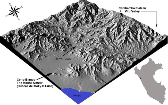
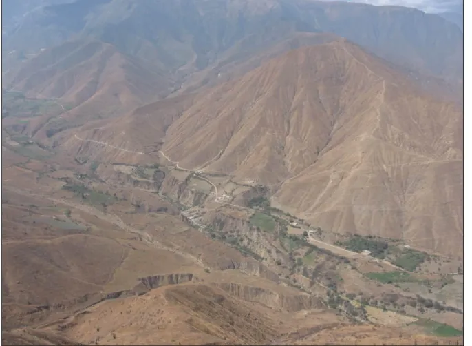
The Moche Valley watershed is drained by three rivers from the Peruvian Andes: the Moche, Sinsicap and Cuesta. The floodplain naturally supports confined riparian vegetation catchments, which have been substantially extended by a large network of canals. The valley floor is a vast network of dry channels filled with alluvial sediments and dispersed river cobbles. Such extreme geophysical characteristics, in addition to the hyper-aridity of the region, create a challenging environment in which to make a living [Figure 2-1]. However, the same ecological and geophysical characteristics that make the environment rugged lend themselves to the excellent conditions for preservation of archaeological material in the region. If it weren’t for rampant looting, going all the way back to Spanish colonization, the
18
Figure 2-1. View of the middle Moche Valley from MV225 on Cerro León. There is a clear distinction between arable land and desert, which obviates the irrigation network. Center and right, architecture from MV223, an early Moche settlement, is visible.
North Coast climate is constant aside from oscillations associated with periodic El Niño events, but the greater Andean environment is characterized by variability. John Murra (1970) coined the term “vertical archipelago”, or verticality, to describe the importance of
19
networks, verticality as a model provides a viable economic perspective on prehistoric settlement decisions and interactions between highland and coastal populations. Throughout the Andean region, exchange of animal products for lowland crops is a well-known strategy for mitigating the effects of unpredictable agricultural yields at high elevations (Julien 1985:196).
20 The Southern Oscillation
El Niño, referring to the baby Jesus, was the term first used in the late nineteenth century by Peruvian fishermen to describe a mysterious episodic phenomenon that developed during the austral summer, often around Christmas. Today, we use the term to describe the ‘warm’ phase of a naturally occurring sea surface temperature oscillation, also known as El Niño Southern Oscillation, or ENSO. Dramatic El Niño events often create a near complete reversal in the Andean climate, not only in terms of sea surface temperature on the coast, but also sea level, which in turn results in changes to relative humidity, air pressure and wind velocity across the entire Andean region. The Southern Oscillation anomaly has an opposite phenomenon, called La Niña Southern Oscillation (LNSO); it is a ‘cooling’ of sea surface temperature. Whereas ENSO warming might generate extreme flooding, drawn-out LNSO events can cause extreme drought.
21
an important episodic event that certainly had consequences for Andean populations making a living in their constricted ecosystems and constructed environments (Billman 1996; Moseley 1987, 1999; Shimada et al. 1991; Wells and Noller 1999). Populations living along the coast were also affected by mild climatic shifts, as any shift in sea temperature would have been significant with regard to maritime resources. As the abundant cold-water aquatic species abandon areas when even the slightest warm current moves in, warm-water fishes colonize the niche. However, this biological turn-over takes a relatively long time, and the process of populating the seas with new aquatic species rarely reaches an equivalent level before cooling begins again.
22
El Niño is an extreme climate perturbation that periodically changes weather throughout the globe, often with dire consequences. Because it was first recognized in Peru, prehistoric and proto-historic El Niño events are well documented (Sandweiss and Quilter 2009). Aside from major climatic shifts associated with ENSO events, the North Coast climate is considerably constant and generally predictable. It is arid and warm, due to the rain-shadow effect of the Andes and proximity to the equator, respectively. Coastal peoples most likely adapted to ENSO events by anticipating the phenomenon through individual life histories (Roff 1992; Smith and Winterhalder 1992; Stearns 1992; Van Groenendael et al. 1994), and contingent cultural memory and group knowledge (Rappaport 1968; Vayda 1977). For example, fishermen probably noticed, as they do today, that warm-water species started showing up in their nets, which would indicate the beginning of an ENSO event. What they could not have known is the severity of the oscillation and its consequences.
23
the environmental disturbance itself is visible in the formation processes of alluvial deposition within cultural contexts. By dating large deposits from a random sample of sites on the North Coast, then cross-checking the dates with geologic records of significant events and comparing them to the cultural chronology, the examination of past weather events can yield new insight into settlement patterns during the Salinar-Gallinazo transition. For example, Huckleberry and Billman (2002) illustrate that the demonstratively increasing frequency of ENSO events at the beginning of the EIP influenced the settlement pattern at that time in the Moche Valley. The photograph below shows the destructive force of ENSO-related flash floods [Figure 2-3].
24
After approximately 400 BCE, Billman (1996) cites evidence for increasing conflict in the Moche Valley; and, by the latter half of the Salinar Phase, population aggregation accelerated within large coastal communities. According to Billman (1996), evidence for warfare peaks at the beginning of the Gallinazo Phase, evidenced by further settlement aggregation on steeper hills with increased fortifications. Billman suggests a model wherein the perceived threat of conflict is more a product of competition among elites than from population pressure and political economies becoming more complex during the EIP (Billman 1996, 2002).
Huckleberry and Billman (2002) present evidence of paleoflood events and severe droughts in the Moche Valley. Their research is based on a radiocarbon-dated sequence of flood and debris flow deposits at Quebrada de los Chinos, an ephemeral tributary of the Moche River. The sequence includes 11 large floods dated between 500 BCE and 700 CE, with six dated between 300 BCE and 200 CE. Huckleberry and Billman (2002) infer from alluvial stratigraphy in the valley that there was an increased frequency of strong El Niño events, followed by prolonged droughts, further suggesting that increased environmental variability occurred during an apparent rise in defensive architecture and settlement patterns. However, Billman (1997) rejects population-oriented theories (e.g., Carneiro 1972; Rappaport 1968) for explaining conflict at this time because irrigated arable land was not scarce during the Gallinazo Phase.
25
repercussions on society that helped shape Andean cultural prehistory on the North Coast (Moseley 1992; Sandweiss et al. 2001). The Southern Oscillation changed considerably throughout the Holocene, generally increasing in strength and frequency (Quinn et al. 1987; Enfield 1989; Rodbell et al. 1999). Periods of sudden and dramatic climate change may have been correlated with periods of rapid cultural change. Political reorganization may have been connected to the increased frequency of El Niño, which generated environmental uncertainty, thus catalyzing the formation of trade and political alliances to offset losses, perhaps even causing engagement in warfare when other mitigating contingencies failed (Sandweiss et al. 2001).
26
Gallinazo Phase of the EIP, leading to the rise of the Southern Moche polity (Huckleberry and Billman 2002).
Huckleberry and Billman (2002) consider the paleoflood record proxy evidence for ENSO-related flooding of the Moche River. By comparing their paleoflood evidence with records of historic El Niño events in the 20th century, they extrapolate that increased flooding during the EIP represents episodic instability at a time when subsistence strategies of both marine resources and irrigated agriculture were particularly vulnerable to severe weather events caused by ENSO (Huckleberry and Billman 2002). If historic analogs are valid, and flood records at their study site and Moche River coincide, then floodplain dynamics and irrigation disruptions would have been at their highest during a 500-year interval between 300 BCE and 200 BCE, coincidentally (or perhaps not so coincidentally) the period for which material evidence indicates migrations to coastal valleys were at their highest (Huckleberry and Billman 2002).
Increased strength and frequency of flooding on the coast often translates to an increase in sustained drought across large areas of the highlands. Highland groups engaged in herding may have experienced food stress during this time as pastures respond to changing weather patterns and the reduction of easterly maritime Trade Winds (Waylen and Caviedes 1986). Slight changes in environmental conditions would have affected rain-fed agricultural systems of the highlands as well, making many agro-pastoral communities particularly vulnerable to disruptions, thereby prompting raids on communities at lower elevations.
27
to 1000 BCE), and perhaps even during the Early Salinar Phase of the EIP (Huckleberry and Billman 2002). Population pressure could have been a problem because areas under cultivation during the early stages of irrigation expansion were by-and-large adjacent to the river and primarily located in the middle valley, an area seemingly most susceptible to El Niño damage. However, Billman (1996) rejected population-oriented theories for explaining warfare during the Late Salinar and Gallinazo Phases of the EIP because the two most critical resources—arable land and irrigation water—were not in short supply; thus, population pressure on those resources would have been negligible. It is also a possibility that an increase in population could have increased the available labor pool with which to repair damage caused by catastrophic flooding. Instead, Billman (1996) favors a model whereby conflict was a result of competition between emerging elites. Nonetheless, both interpretations of culture contact are conflict-centered and derived from the position that a series of disruptive Southern Oscillation events beginning around 300 BCE may have led to hostile highland/coastal interaction in the Moche Valley leading up to the Gallinazo Phase.
28
My research provides compelling evidence to the contrary. As I mentioned previously, relationships between the populations of interest in my study were probably less bellicose than previously thought. Settlement patterns of nonlocal migrants in the Moche Valley during the EIP are a result of clustering that occurred around status-striving elites filling open niches created by an expanding irrigation network. Elite households and their followers made a living in spite of environmental uncertainty, resulting from ENSO and LNSO weather events, or other natural disasters common to the region, like earthquakes.
North Coast Culture Chronology
29
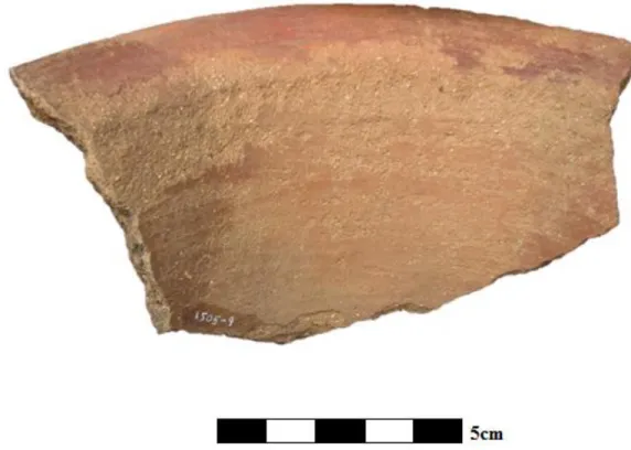
Figure 2-4. Sherds from storage vessels with roughly the same rim diameter, the nonlocal (presumably highland) example is on the left; the coastal example is pictured on the right.
Among the earliest records of the peopling of South America is an archaeological site at Tacahuay on the southern coast of Peru. The site dates to around 10,500 BCE and contains someof the earliest evidence of maritime-based economic activity inthe New World (Keefer et al. 1998). To the north, between 9,000 and 7,000 BCE, Paijan culture represents one of the earliest and most significant human populations in the region, identified by the Paijan Point. The bifacial point is distinctively long, usually between 10cm and 20cm, and fashioned with a small tang on the hatch.
30
aspect of the development of risk reduction, exploitation of resource rich habitats, excess food and energy, and new social structures, all of which helped to plant the seeds of early civilization.
Table 1. North Coast Cultural Chronology
31
The settlement pattern of Preceramic Period sites on the North Coast indicates that early inhabitants intended to maximize access to fishing and hunting, harvesting shellfish and wild plants, while maintaining proximity to land used presumably for cultivation in the lower valleys. Preceramic settlements in many cases also had access to nearby lomas, or hills, rich in bromeliads for gathering, and by extension, good hunting grounds for terrestrial animals. At least two Preceramic Period sites in the Moche Valley, Padre Alban and Alto Salaverry, are indicative of this pattern, that is, continued exploitation of marine and faunal resources while increasing plant cultivation (Pozorski 1983). As Sandweiss (1996) notes, rising sea level after approximately 4,000 BCE (the beginning of the Late Preceramic Period) probably caused marine-based populations to move further inland, closer to farmers. Human settlement patterns during the Preceramic Period on the North Coast coevolved with changes in the natural environment (Wells and Noller 1999).
32 Initial Period
33
Figure 2-5. Northern river valleys with ceremonial centers discussed in this section.
34
red clay floors (Matsuzama 1978). Excavated by the Pozorskis in the 1980’s, middens contained many varieties of seafood remains, including deepwater fish, which requires advanced fishing technology; but they also found at this site, evidence for cultivation of maize, cotton, avocado, beans, squash, and gourd (Pozorski and Pozorski 1987). Some buildings were abandoned before completion, and while it is not known exactly why, one idea is that interaction with agriculturalists upriver drew people away from the coast (Pozorski and Pozorski 1987). This assertion is supported not only by the presence of food crops and cotton, but also by the discovery of a 2 km long section of a large causeway (60 m at its widest point), leading toward the river about 30 km from the coast (Pozorski and Pozorski 1987). This is some of the earliest evidence indicating mixed subsistence strategies, and potentially indicative of early cultural contact and interaction among different populations inhabiting North Coast river valleys.
35
with human body parts, most of which are bleeding trophy heads. Dated to around 1,200 BCE, the gruesome iconography is earlier than similar depictions at Chavín de Huántar, located in the highlands, dated to the beginning of the Early Horizon Period.
The meaning of such a motif is hard to interpret and no doubt carries diverse significance across different geographies and throughout time periods. Interestingly however, a very similar motif is found in the Olmec and Maya cultures, as well as in many areas in the Southeastern U.S. and among prehistoric cultures and geographies across North and South America. For whatever reason ancient populations carved these images, it seems that interpersonal violence tends to increase with emerging social complexity. At the Sechin complex, it is difficult to determine whether ceremonial lines depicted in the iconography are composed of warriors. They may be representations of mythical beings or real people, perhaps both. They could be evidence for veneration for war parties from this area during the Initial Period, but just as likely, they may represent a local response to raiding. Burger (1992) posits the depictions at Cerro Sechin do not indicate large-scale warfare because the complex is in a militarily vulnerable position and that the residents living nearby would have constructed more defensive structures in association with the site. On the other hand, while it is true that overtly defensive architecture does not appear in most of the river valleys on the North Coast until after the Initial Period, Sheila and Thomas Pozorski (1987) propose there is clear evidence for endemic conflict by this time period.
36
compared with only 115 m3 in the former. He further qualifies those numbers by stating that nearly all of the volume of ceremonial architecture was concentrated at Huaca Menocucho, with the remainder of the volume spread out across five small centers in the valley. Huaca Menocucho is located near the geographical center of the middle valley, where ritual ceremonies would have been more accessible. By the Middle Guañape Phase, Caballo Muerto, with an estimated 282,800 to 318,700 m3 of new construction for ritual function, suggests increasing social stratification indicative of semi-private access to ritual ceremony (Billman 1999). According to Billman (1999) the communities surrounding Caballo Muerto, and two secondary sites at Puente Serrano and Huaca los Chinos, may have developed a three-tiered hierarchy of political power, mirrored by the tertiary structure of these monuments. The society may have been stratified by an elite group with control to a valley-wide labor pool; a secondary group of leaders with local labor pools; and a third tier of village leaders. However, by the Late Guañape Phase of the Initial Period, at the beginning of the Early Horizon Period, ceremonial architecture was in decline and no single center appears to have dominated the social landscape of the Moche Valley.
Early Horizon Period
37
build temples with limited access suggests a high degree of asymmetrical power within Chavín society (Rodriquez and Rick 2004). Existence of an elite class, often referred to as shamanistic and known locally as the Cult of San Pedro (San Pedro is a hallucinogenic cactus), is indicative of an evolution of authority resulting from the intentional manipulation of constituent populations by those who planned and constructed the temples at Chavín de Huántar, the nexus of Andean society at that time (Rick 2005). The culture is also known for its advanced metallurgy; Chavín artisans invented techniques to develop beautiful golden objects unlike anything witnessed previously (Lothrop 1951). The sphere of Chavín influence extended westward from the highlands to the north and central coasts and into the eastern cloud forests. Interestingly, while their iconography is often suggestive of violence, there is little evidence for a standing army. Theirs was a conquest of ideology rather than bloodshed.
38
Indicated by the similarity of some artistic styles, perhaps there is a connection between Chavín and Cupisnique people, but unfortunately the relationship between them is not well established from the current archaeological record. Since Larco Hoyle first discovered the Cupisnique culture in 1939, the names have been used interchangeably in some of the literature on the North Coast. In recent years, there has been more resolute theoretical division on the subject. Cordy-Collins (1992) treats Cupisnique as a culture lasting from about 1000 BCE to 200 BCE, which corresponds to the Chavin culture in the highlands, and asserts that contact between the two groups was inevitable. On the other hand, Shimada (1994) describes the Cupisnique as having an ancestral relationship with Moche culture, but he gives no real credence to the possibility that Chavin directly influenced either culture.
39
The transition out of the Early Horizon Period may have been a time of turmoil and disorganization in the region, as it corresponds with the abandonment of Sechín Alto and other similar large ceremonial centers further south. After about 500 BCE, coastal populations spread out into dispersed settlements, suggesting a fracturing of regional ideology that had previously emphasized inclusion into one of a loosely connected congregation of localized semi-autonomous villages. Construction of monumental architecture declined dramatically after this transition, further indicating a wide-spread demographic move toward protectionism and isolationism among valley populations.
Early Intermediate Period
40
In the lower Moche Valley, the site of Cerro Arena is estimated to be over 200 ha and constitutes one of the largest nucleated residential sites on the North Coast, consisting of more than 2,000 separate structures. The settlement is the first large Salinar Phase site to be extensively excavated (Brennan 1980). Much of what we know about Salinar Phase settlement comes from investigations at Cerro Arena and informs our understanding of the development of urbanism on the North Coast. Billman (1996:212-215) suggests that during the early Salinar Phase, hierarchies formed at a number of autonomous clusters in the Moche Valley and nine of those clusters may have consolidated to form a loose confederacy from which the Cerro Arena polity appears to have exacted tribute. By the end of the Salinar Phase “the middle [Moche] valley population apparently was unified into a single polity centered at Cerro Oreja” roughly 9 km away from Cerro Arena, with no Salinar settlements
in between (Billman 2002:389). It is during the Salinar Phase that construction of defensive architectural planning became increasingly prevalent, presumably due to increased raiding from the highlands or other coastal groups. In neighboring river valleys on the North Coast, such as the Virú and Santa River valleys, there are more than 60 documented hilltop bastions that date to the end of the Early Horizon or the beginning of the EIP (Topic and Topic 1978, 1987; Wilson 1988, 1995).
41
middle valley at this time, in the size and relative location of structures, which presumably mirrors politically-sanctioned social stratification. The two largest Gallinazo sites are Pampa Cruz and Cerro Oreja; these two sites alone account for 37% of the known habitation area during this phase of the EIP (Billman 1996). During this period, nonlocal migrants begin to colonize coastal river valleys.
Pampa Cruz is located on a bluff above Huanchaco. In 2005, a colleague and I mapped the remaining portion of the site with a total station set up on the rooftop of the field house. Most of the site has been destroyed by development. It was a relatively large fishing village bounded on the west by the Pacific Ocean and on the northwest by the Rio Seco. Excavations were conducted at the site on four separate occasions by Donnan (1978), Mujica (Chan Chan-Moche Valley Project), Ricktenwald (Chan Chan-Moche Valley Project), and Barr (Instituto Nacional de Cultura, Peru). Mujica's and Ricktenwald's field notes in the Chan Chan-Moche Valley Project files contain considerable information on the site (Billman 1996). While the site has Salinar, Gallinazo, and Moche Phase deposits, the Gallinazo Phase occupation appears from test excavations to have been the most extensive settlement (Donnan 1978). There is one small huaca in association with this site.
42
pottery underfoot. Although Cerro Oreja has Guañape, Salinar, Moche, and Chimú Phase occupations, like Pampa Cruz, the Gallinazo Phase occupation is the most extensive (Billman 1996).
Settlement patterns of the Gallinazo Phase are best characterized by widespread site abandonment in the upper middle valley and dramatic population increases in the lower middle valley and along the coast. At Pampa Cruz, which already had a considerably large late Salinar Phase population, occupation was continuous and appears to have grown substantially during the Gallinazo Phase (Billman 1996). In the lower middle valley between Cerro Oreja and the confluence of the Moche and Sinsicap Rivers, the area of habitation nearly doubled in the Gallinazo Phase from 46.44 to 81.14 ha (Billman 1996). The valley neck, where Cerro Oreja is located, experienced very high population growth, with an estimated 25% of the total Gallinazo Phase habitation concentrated there (Billman 1996). The large Salinar settlement at Cerro Arena was in effect abandoned by this time, and Cerro Oreja took its place as the largest habitation site in the Moche Valley.
43
nonlocal components, it appears that these sites were situated as to control access to the upper and middle Moche valley, as well as important corridors to the neighboring Virú Valley. For highlanders, control of this area would have provided both the economic incentive of proximity to a prime coca-growing zone on the western slopes of the Andes and strategic access to the Carabamba Plateau and Otuzco Basin.
Billman (1996) concludes that there were three elite groups in the middle valley. These three clusters prove to be extremely significant in my investigation. The elite families of these groups appear to have lived in stylistically distinct residences with a higher degree of refined architectural craftsmanship. Their homes were exclusive compounds contained within larger, aggregated settlements. Architectural forms of elite and commoner households, of the nonlocal and local varieties, are described in Chapter 4.
Nonlocal elites may have derived their political status from control over production regimes and brought with them some degree of military power. One of these clusters occupied much of the prime coca-growing zone in the upper valley; control over the production and exchange of coca would have been an important source of economic influence. Comparison of surface collections from Billman’s middle valley survey and the
44 Early Intermediate Period: Rise of the Mochica
By the end of the Gallinazo Phase, a local polity known as the ‘Gallinazo Group’ had emerged in the neighboring Virú Valley, while the controlling entity in the lower Moche Valley remained centralized at Cerro Oreja and later organized into the southern Moche polity. During the early Moche Phase of the EIP, populations in the Moche and neighboring Chicama Valley merged into a nascent two-valley polity. The capital of the Southern Moche polity was relocated to the site of Moche, in the Moche Valley, and construction of two massive adobe pyramids began in the years that followed: Huaca del Sol and Huaca de la Luna. The Gallinazo Group in the Virú Valley eventually gave way to Moche hegemony, along with the rest of the North Coast. Seven hundred years of Moche cultural development from 100 to 750 CE is commonly divided into five temporal stages: Moche I – V, but often collapsed into three Moche Phases: Early, Middle and Late.
45
development it is unlikely that the two monuments represent opposing powers. However, during the Middle and Late Moche Phases of the EIP, between Moche III and IV, another large political center was established at Pampa Grande in the Lambayeque Valley to the north. As a result of this new political center, Moche power was distributed across confederations of related, allied polities (Pillsbury 2001:9-12).
By Moche V (ca. 700 CE), much of the territory under control of the capital at Moche may have been partially incorporated under a different regional administration characterized by a completely new style of nonlocal ceramics found in eight principal river valleys on the North Coast (Wilson 1998). Black-White-Red pottery was found in the Moche, Virú, Chao, Santa, Nepeña, Casma, Chicama, and Huarmey Valleys.
Middle Horizon Period
46
diagnostics that signal an end to the Moche/Chimú transition and the beginning of a strictly Chimú ceramic tradition: the wide-spread manufacture of grey ware ceramics [Figure 2-6]; and, a stylistic change from painted, incised designs to the quintessential Chimú press molded designs (Bawden 1982; Donnan and Mackey 1978).
Figure 2-6. Chimú press-mold grey ware.
Late Intermediate/Late Horizon Period