ISSN: 2394-2231 http://www.ijctjournal.org Page 1
Indoor Localization System Using WiFi RSSI
1M.Divya,2P.karuthammal ,3G.Natchiar Department of Computer Science of and Engineering Chandy College of Engineering
Thoothukudi(T.N)India
Abstract— Indoor localization is of great importance for a range of pervasive applications, attracting many research efforts in the pastdecades.In this study, we investigate novel sensors integrated in modern mobile phones and leverage user motions to construct the radio map of a floor plan, which is previously obtained only by site survey. On this basis, we design LiFS, an indoor localization system based on off-the-shelf WiFi infrastructure and mobile phonesfingerprint-based indoor localization system designedand built to run on mobile phones.Experiments carried out in a single- and a multi-story building revealed that the proposed method could successfully build a precise localization model without any location reference or explicit efforts to collect
labeled samples. By exploiting user motions
from mobile phones,we successfully remove the site survey process of traditional
approaches,while at the same
time,competitive localization accuracy.
Intex terms—location estimation,Wifi Finger print,RSSI
1 . INTR UCTION
wireless devices and WLANs (based on the IEEE 802.11 standard) is acceler-ating the demand for practical location-based applications in indoor environments. In such applications, the dentifica-tion of a user’s locadentifica-tion in an indoor area is critical because the Global Positioning System (GPS) is usually unavailable due to signal blocking. Instead, WLAN infrastructure allows a wireless device to be localized by referring to the Received Signal StIndicator (RSSI) in an indoor environment.
RSSI-based techniques, fingerprinting is
known to be the most accurate and popular approach to indoor localization [1]. The RSSI fingerprinting-based techniques, however, require an initial training or calibration phase in which RSSI measurements are collected at known locations. Then, in the localization phase, the location of a device is estimated by matching an
online RSSI measurement with the training data
The cost of manual calibration thus hinders the widespread adoption of finger-printing-based indoor localization. In endeavors to reduce the calibration efforts, several studies have been carried out on crowdsourcing approaches in which general users can participate in the data collection activity. Implicit crowdsourcing, besides explicit contribu-tion approaches [4], [5], [6], has been studied to make use of RSSI measurements contributed during the normal opera-tion of wireless devices [7], [8]. This type of data can be viewed as unlabeled samples since the true positions from which the measurements are obtained are unknown. There-fore, the issue that must be addressed is the assignment of correct location labels to the unlabeled samples for the calibration of localization models.
Another research stream is focused on semi-supervised learning techniques that utilize both labeled and unlabeled samples [13], [14], [15], [16], [17], [18], [19]. These studies employ optimization techniques to estimate location labels of unlabeled samples based on RSSI values. In this paper, we propose an unsupervised learning method, named Unsupervised Calibration based on a Mem-etic Algorithm (UCMA), to build a precise indoor locali-zation model using only unlabeled fingerprints.
ISSN: 2394-2231 http://www.ijctjournal.org Page 2
prob-lems through the interaction between global and local optimizations.Two main problems should be addressed to avoid the need for loca-tion-labeled data and to perform the unsupervised learning of a localization model. The first is the mapping of a learned model onto an indoor space. In the previous learning-based methods, this has been solved by using location-labeled sam-ples as reference points for the mapping. UCMA solves this problem by incorporating the structural information of an indoor area and human mobility constrained by the struc-ture. Once the indoor map of a building and unlabeled user traces are given, UCMA arranges the traces to fit into the inner structure shown in the map, like fitting pieces into a puzzle. Similar approaches have been used before in a few studies [8], [10], [13]. However, the suggested approaches still depend on some amount of labeled samples [13] or data from inertial sensors [8], [10] because of the second problem.
This problem is related to the size and the complexity of a solution space to be dealt with. In general, the solution space of a location assignment problem is huge and complex since it comprises all possible assignments of location labels to given samples. Suppose that 1,000 unlabeled samples are col-lected from a building composed of 100 locations. There are then 1001,000 possible solutions to the assignment problem. With such a huge solution space, optimization algorithms usually fail to find the global optimal solution or do not ter-minate. To address this problem, an effective configuration of the global search and local optimization algorithms was deliberately devised in the proposed hybrid scheme. Under the configuration, only the solutions that do not violate the nature of signal propagation are discovered and evaluated during the interaction between the global and local optimiza-tions. In this way, the solution space is effectively restricted to a much smaller space, and thus a localization model can be constructed via unsupervised learning.
To validate UCMA, we deployed a prototype system and conducted extensive experiments in a medium- and a large-scale building. The experimental results revealed that
UCMA could build a precise localization model using unla-beled user traces. In the medium-scale building, a localiza-tion test of UCMA yielded average errors of 2.7-3.7 m under various conditions, a level comparable to the error of 1.6-2.8 m achieved with the ground-truth model. In the large-scale building where the ground-truth model yielded aver-age errors of 2.0-3.7 m, UCMA yielded average errors of 3.1-4.6 m. These results indicate that a localization service can be provided by implicit crowdsourcing, where training data are gathered during the normal operation of wireless devi-ces. In this way, the cost of building an indoor localization system can be dramatically reduced.
2.RELATED WORK
2.1WIFI RSSI Based Indoor Loacalization
2.1.1 Trilateration-Based Approach:
This approach estimates the location of a wireless device based on a mathematical principle called “trilateration”. It assumes that APs’ installed locations are known, and esti-mates the location of a device based on the distances between the device and the APs. Their distances can be cal-culated using the correlation between signal strength and distance given a propagation model [21]. At least n
þ 1 APs are needed to calculate a location in n dimensions, e.g., three APs are required in 2D space, and four, in 3D.
Trilateration-based techniques are simple and require a little calibration effort. However, trilateration-based techni-ques are known to show comparably low accuracy [22]. Moreover, most of the APs’ locations are not known in real-ity because many different vendors and providers are usu-ally involved in the installation of APs for public areas such as large-scale indoor shopping malls.
2.1.2 Fingerprint based approach :
ISSN: 2394-2231 http://www.ijctjournal.org Page 3
measurement with fingerprints in thetrained model. RADAR, one of the pioneering finger-printing-based systems, estimates the location of a device based on k-Nearest Neighbor (kNN) averaging [2].
we present experimentalresults that demonstrate the ability of RADAR to estimateuser location with a high degree of accuracy.
The training data set is usually collected through a labor-intensive man-ual calibration. Furthermore, this manual calibration must be repeated if the training data are outdated due to changes in the WLAN environment such as addition, removal, and relocation of APs.
3.EXISTING SYSTEM
• Most of these techniques utilize the RF signals.
• Most radio-based solutions require a
process of site survey, in which radio signatures of an interested area are annotated with their real recorded locations. Site survey involves intensive costs on manpower and time, limiting the
applicable buildings of wireless
localization worldwide.
• Google released Google Map 6.0 that
provides indoor localization and
navigation available only at some selected airports and shopping malls in the US and Japan.
• The enlargement of applicable areas is
strangled by pretty limited fingerprint data of building interiors.
Unsupervised learning techniques have not been fullyapplied to the calibration of localization models. Two mainproblems should be addressed to avoid the need for location-labeled data and to perform the unsupervised learningof a localization model. The first is the mapping of a learnedmodel onto an indoor space. In the previous learning-basedmethods, this has been solved by usinglocation-labeled samplesas reference points for the mapping. UCMA solves thisproblem by incorporating the structural information of anindoor area and human mobility constrained by the structure.
Once the indoor map of a building and unlabeled user
traces are given, UCMA arranges the traces to fit into the
inner structure shown in the map, like fitting pieces into a
puzzle. Similar approaches have been used before in a few
studies [8], [10], [13]. However, the suggested approaches
still depend on some amount of labeled samples [13] or data
from inertial sensors [8], [10] because of the second problem.
4.PROPOSED SYSTEM
The localization approaches utilize
Received Signal Strength (RSS) as a metric for location determinations. RSS fingerprints can be easily obtained from most off-the-shelf wireless network equipments, such as WiFi- or ZigBee-compatible devices. In these methods, localization is divided into two phases
. 1) training Stage 2) operating Stage 1) Training:
In the first stage, traditional methods involve a site survey process (a.k.a. calibration), in which engineers record the RSS fingerprints (e.g., WiFi signal strengths from multiple Access Points, APs) at every location of an interested area and accordingly build a fingerprint database (a.k.a. radio map) in which fingerprints are related with the locations where they are recorded.
2) Operating Stage:
The operating stage, when a user sends a location query with his current RSS fingerprint, localization algorithms retrieve the fingerprint database and return the matched fingerprints as well as the corresponding locations.
• To find the best matches, many searching
ISSN: 2394-2231 http://www.ijctjournal.org Page 4
• In fingerprint database, fingerprints are
associated with their collecting locations (i.e., fingerprints are labeled with locations)
5.EXPERIMENTATION
6.ALGORITHM
• K-MEANS ALGORITHM
• Put the first K feature vectors as initial
centers
• Assign each sample vector to the cluster
with minimum distance assignment principle.
• Compute new average as new center for
each cluster
• If any center has changed, then go to step 2,
else terminate.
•
The advantages of the method are itssimplicity, efficiency, and self-organization. It is used as initial process in many other algorithms.
ISSN: 2394-2231 http://www.ijctjournal.org Page 5
for k APs detected in a target indoor environment. A genotype may have the same formatas that of the phenotype with a limited range of RSSI values.In this case, however, the genotype space is extremely large.
7.EVOLUTIONARY PROCESS
The GA operations comprise selection, crossover, and mutationfunctions. UCMA adopted a general strategy for each ofthese three operations: roulette wheel selection, uniformcrossover, and randommutation respectively.
The evolutionary process of an MA starts with an initialpopulation of chromosomes. UCMA generates the initialpopulation randomly and iterates as follows:
1. Compute the phenotype m0 for each genotype by calculatingattenuated RSSIs for each AP and at eachlocation-state using (15).
2. Enhance each phenotype m0 into m_ using SKðm0; UÞ.
3. Update each genotype based on the enhanced phenotypem_ using (16) and (17).
4. Build a new population by means of the GAoperations.
5. Stop if a termination criterion is satisfied, or repeatthe iteration from step 1.In the process of a local optimization, intermediate andfinal changes of a phenotype are evaluated, and the finalevaluation score is transferred to the updated genotype.
EXPERIMENTATION&RESULT ANALYSIS
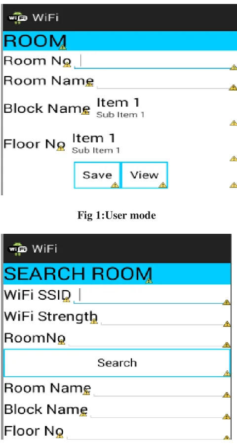
Fig 1:User mode
ISSN: 2394-2231 http://www.ijctjournal.org Page 6 Fig 3:WIFI Range calculaction
8.CONCLUSION
In this project is presented UCMA, an
unsupervised calibrationmethod that can build an indoor localization systemusing unlabeled RSSI measurements. Simple modeling andoptimization techniques were employed in unsupervisedlearning on the unlabeledmeasurements.The evaluation onthe two office buildings confirmed that, under various conditions,the proposed method can build a precise localizationmodel without any location reference.An indoor map and online RSSI measurements are twoessential requirements in the service phase of fingerprinting-based localization systems. UCMA uses only the twoinputs for the calibration,whereas conventional approachesrequire extra inputs or extensive efforts. This indicates thata localization system can be implemented by UCMA withoutadditional cost except computational cost on the serverside. In that sense, the technique has the potential to makesignificant progress in indoor localization, especially in realizinga global indoor positioning system
REFERENCE
1.J.Yim, S.Jeong, K.Gwon,andJ.Joo, “Improvement of Kalman filtersfor WLAN based indoor tracking,” Expert Syst. Appl., vol. 37,no. 1, pp. 426–433, 2010.
2.P. Bahl and V. N. Padmanabhan, “RADAR: An in-building RFbaseduser location and tracking system,” in Proc. 19th Annu. JointConf. IEEE Comput. Commun. Soc., 2000, vol. 2, pp. 775–784.
3.D. Han, S.H. Jung, M. Lee, and G. Yoon, “Building a Practical Wi-Fi-Based Indoor Navigation System,” IEEE Pervasive Comput., vol. 13, no. 2, pp. 72–79, Apr.–Jun. 2014.
4. A. LaMarca, Y. Chawathe, S. Consolvo, J. Hightower, I. Smith, J.Scott, T. Sohn, J. Howard, J. Hughes, F. Potter, J. Tabert, P. Powledge,
G. Borriello and B. Schilit, “Place lab: Device Positioningusing Radio Beacons in the Wild,” Pervasive Computing. Heidelberg,Germany: Springer, 2005, pp. 116–133.
5. P. Bolliger, “Redpin-adaptive, zero-configuration indoor localizationthrough user collaboration,” in Proc. ACM Int. WorkshopMobile Entity Localization Track. GPS-Less Environ., 2008, pp. 55–60.Mobile Comput. Network., 2012, pp. 269– 2806.
6.M. Lee, S. H. Jung, S. Lee and D. Han, “Elekspot: A platform forurban place recognition via crowdsourcing,” in Proc. IEEE/IPSJInt. Symp. Appl. Internet, Jul. 2012, pp. 190–195.
7.H. Wang, S. Sen, A. Elgohary, M. Farid, M. Youssef, and R. R.Choudhury, “No need to war-drive: Unsupervised indoor localization,”in Proc. 10th Int. Conf. Mobile Syst., Appl., Serv., 2012,pp. 197–210
8. A. Rai, K. K. Chintalapudi, V. N. Padmanabhan, and R. Sen, “Zee:Zero-effort crowdsourcing for indoor localization,” in Proc. 18thAnnu. Int. Conf. Mobile Comput. Network., 2012, pp. 293–304. 9. Z. Yang, C. Wu, and Y. Liu, “Locating in fingerprint space: Wirelessindoor localization with little human intervention,” in Proc.18th Annu. Int. Conf. 2015
10. C. Wu, Z. Yang, and Y. Liu, “Smartphones based crowdsourcingfor indoor localization,” IEEE Trans. Mobile Comput., vol. 14, no. 2,p. 444–457, Feb.