http://wrap.warwick.ac.uk
Original citation:
Chmutina, Ksenia, Bosher, Lee, Coaffee, Jon and Rowlands, Rob (2014) Towards
integrated security and resilience framework : a tool for decision-makers. Procedia
Economics and Finance, Volume 18 . pp. 25-32. ISSN 2212-5671
Permanent WRAP url:
http://wrap.warwick.ac.uk/65597
Copyright and reuse:
The Warwick Research Archive Portal (WRAP) makes this work of researchers of the
University of Warwick available open access under the following conditions.
This article is made available under the Creative Commons
Attribution-NonCommercial-NoDerivs 3.0 (CC BY-NC-ND 3.0) license and may be reused according to the
conditions of the license. For more details see:
http://creativecommons.org/licenses/by-nc-nd/3.0/
A note on versions:
The version presented in WRAP is the published version, or, version of record, and may
be cited as it appears here.
Procedia Economics and Finance 18 ( 2014 ) 25 – 32
2212-5671 © 2014 Published by Elsevier B.V. This is an open access article under the CC BY-NC-ND license (http://creativecommons.org/licenses/by-nc-nd/3.0/).
Selection and/or peer-reviewed under responsibility of the Centre for Disaster Resilience, School of the Built Environment, University of Salford. doi: 10.1016/S2212-5671(14)00909-5
ScienceDirect
4th International Conference on Building Resilience, Building Resilience 2014, 8-10 September
2014, Salford Quays, United kingdom
Towards integrated security and resilience framework: a tool for
decision-makers
Ksenia Chmutina
a*, Lee Bosher
a, Jon Coaffee
b, Rob Rowlands
b aSchool of Civil and Building Engineering, Loughborough Univeristy, Lougborough, LE11 3TU,UKbCentre for Interdisciplinary Methodologies, University of Warwick, Coventry, CV4 7AL, UK
Abstract
Recent disasters such as Super Storm Sandy, the Haitian Earthquake and extensive floods across the United Kingdom have highlighted the fragility of cities to a range of hazards and threats thus emphasizing the increasing importance of resilience and disaster risk reduction (DRR) in relation to the management of the built environment. While this makes the role of planning, design and construction stakeholders crucial in implementing the principles of DRR, tensions exist regarding the extent to which DRR measures should be implemented during planning, design and construction process; in particular who should be responsible for the implementation of such measures. This paper presents a web-based Decision-Support System Portal (DSSP) developed during a four-year European Union-funded project which is examining the design and planning of safer urban spaces. Central to the project is an integrated security and resilience (ISR) design framework that engages local stakeholders (that can typically be otherwise disengaged in such matters) in identifying vulnerabilities and improving urban spaces with respect to ‘security threats’. The DSSP signposts a broad range of users to relevant advice and guidance that will help them to make more informed decisions about how DRR can be integrated into urban design and planning.
© 2014 The Authors. Published by Elsevier B.V.
Selection and/or peer-reviewed under responsibility of the Centre for Disaster Resilience, School of the Built Environment, University of Salford.
Keywords: Decision support; web-based tool; disaster risk reduction; built environment
* Corresponding author. Tel.: +44 (0) 1509228526
E-mail address: [email protected]
© 2014 Published by Elsevier B.V. This is an open access article under the CC BY-NC-ND license (http://creativecommons.org/licenses/by-nc-nd/3.0/).
26 Ksenia Chmutina et al. / Procedia Economics and Finance 18 ( 2014 ) 25 – 32
1.Introduction
There is growing concern about the increasing complexity of disasters and the impacts they can pose to society, with the fragility and vulnerability of the built environment being particularly highlighted (Bosher, 2008). In order to reduce disaster risks, Disaster Risk Reduction (DRR) approaches have been proposed that can systematically analyze and manage the casual factors of disasters ‘through reduced exposure to hazards, lessened vulnerability of people and property, wise management of land and the environment, and improved preparedness for adverse events’ (UNISDR, 2011). Spatial planning is increasingly becoming an attractive and important approach for DRR, as it presents an opportunity to regulate long-term use of space through which exposure to natural hazards and human-induced threats can be minimized (Sutanta et al., 2010; Coaffee et al., 2008). In order to protect societies and economies it is important to understand the sensitivity of the built environment and the necessity to adapt it to the impacts of a multitude of hazards and threats. This can be achieved through pro-active DRR measures implemented during the design, planning, construction and operation process by the construction professionals, whose knowledge and experience fits into DRR approaches (Bosher et al., 2007). The involvement of construction professionals in DRR has in the past largely been associated with a range of critical activities such as temporary shelter before and after the disaster as well as the restoration of public services (e.g. hospitals, schools power lines) (World Bank, 2001). In reality, however, construction experts have a much broader role to anticipate, assess, prevent, prepare, respond and recover (Keraminiyage et al. 2007).
A number of recent extreme weather events and man-made threats have shown that timely and effective reactive measures (i.e. emergency response and recovery) are not sufficient in keeping the built environment safe; it is vital to deal with hazards and threats proactively, with the wide range of the stakeholders being involved (Chmutina et al. 2014). Stakeholders’ engagement is however often affected by the lack of understanding that the risks can potentially be minimized or even prevented if DRR measures are thought of at an early enough stage of the design, planning, operation and construction process.
There is an increasing amount of information and guidance on how natural hazards can be eliminated/reduced/mitigated/designed-out through urban planning and design interventions; such information is supported by a variety of online-based open access tools aimed at assessing security and resilience of urban spaces. The range of guidance, tools and approaches typically vary depending on the types of hazards/ threats that need to be addressed and many are context/country specific in their requirements. In addition, some of these tools are too complex and technical, whereas others focus on either natural hazard(s) or man-made threat(s).
The aim of this paper is to introduce a web-based Decision-Support System Portal (DSSP) developed during a four-year European Union-funded project which is examining the design and planning of safer urban spaces. The DSSP is a multi-hazard open access tool that helps stakeholders involved in design, planning, construction and operation as well as local authorities to better understand the vulnerabilities and design possibilities of the proposed site by allowing users to pursue decision-support scenarios of secure urban design and planning.
The following section introduces the backbone of the DSSP. Section 3 will then describe the process of information analysis and decision support, and section 4 will provide conclusions.
2.Integrated security and resilience (ISR) design framework
The ISR framework has been designed to help users to design safer urban spaces, through a stage-by-stage process, and acts as the core of the DSSP tool. Central to the development of the ISR framework has been the adherence to, and further development from, an international standard on risk management (British Standards Institution, 2011; 2009). The international risk management standard ISO 31000 ‘Risk management – Principles and
guidelines‘(British Standards Institution, 2011; 2009) presents four stages, those being risk identification,
Table 1 ISR stages description [after Bosher 2014]
ISR Stage Descriptor
1 Identify, characterize, and assess hazards/threats
Hazard/Threat identification – the process of finding, recognising and describing hazards/threats to which the space is exposed.
2 Assess the vulnerability of urban spaces to specific hazards/threats
Vulnerability assessment is the process of assessing the susceptibility of the intrinsic properties (the structure, materials, construction and planning) to a hazard/threat that can lead to an event with a consequence
3 Determine the risk (i.e. the expected consequences of specific hazards/threats on specific assets)
Identifying the level of risk - magnitude of a risk or combination of risks, expressed in terms of the combination of the likelihood (chance of something happening) and the impact (consequences) of an incident caused by that hazard/threat. It utilises a Risk Matrix as a tool for ranking and displaying risks by defining ranges for consequence and likelihood
4 Identify ways to reduce those risks Inherent safety (eliminate the possibility of hazards/threats occurring)
Prevention (reduce the likelihood of hazards/threats)
Detection (measures for early warning of hazards/threats) Control (limiting the size of the hazards/threats)
Mitigation and adaptation (protection from the effects of hazards/threats)
Emergency response (planning for evacuation and access for emergency services)
Identifying (and prioritising) a course of action to address and treat the hazard/threat and its associated risks. Treatment can involve:
• avoiding the risk by deciding not to start or continue with the activity that gives rise to the risk;
• removing the hazard/threat source; • changing the likelihood or magnitude; • changing the consequences;
• protecting assets/spaces from the effects of the risk • preparedness planning for the impacts of risks (events)
• sharing the risk with another party or parties [including contracts and risk financing]; and
• retaining the risk by informed decision making 5 Prioritise risk reduction measures
Since the ISR framework is based upon an accepted international standard such as ISO 31000, it is anticipated that it will provide suitable relevance (in functionality and terminology used) across Europe and globally. Being based on the ISR, the DSSP can be applicable to a range of urban contexts (i.e. city, building, organisation); a broad range of professions (i.e. planners, architects, security consultants, engineers, local authorities); and covering a range of countries (Pan-European and global).
3.Overview of the ISR process in DSSP
This section will present a stage-by-stage ‘walk-through’ process that informs the logic behind the DSSP. The DSSP covers both natural hazards and man-made threats including: floods and storms; earthquakes; terrorism and crime; and crowded events. From the end-user point of view, the ISR addresses the following:
•Help in decision making;
•Provides a structure in which to understand hazards, threats and risks; •Illustrates why the suggested steps should be taken;
•Offers a method of understanding the threats, hazards and risks the end-user faces in the designed space; •Provides examples of how each risk can be reduced or eliminated;
•Offers a paper trail that will provide a record of which steps could be/have been taken by the end user.
3.1. Stage 1: What are the hazards/ threats to this site
The aim of this stage is to help the end-user begin recognising the threats and hazards to which the chosen project space is exposed. This may sounds like a straightforward requirement but research has found that this critical stage is too often overlooked by key decision makers (see Bosher et al. 2007; Fisher et al. 2012) This is achieved through the description and identification of the hazards and threats provided by the end user. This stage involves two steps:
28 Ksenia Chmutina et al. / Procedia Economics and Finance 18 ( 2014 ) 25 – 32
[image:5.544.54.488.116.316.2]• Based on the impact table, a range of possible and likely impacts of X are identified (Table 2). The impact rating developed in this step will then be used in ISR Stage 3.
Table 2 Impact of a hazard/ threat
Impact Physical Damage Economic and Business Disruption Social Disruption
VERY HIGH Massive physical damage to infrastructure of national significance.
Long-term damage to the financial well-being of similar businesses throughout the nation leading to bankruptcy / closure.
Significant disruption for a prolonged period throughout the nation.
HIGH Major damage to infrastructure of regional and city wide
significance.
Long-term damage to the financial well-being of similar businesses throughout the region potentially leading to bankruptcy/closure.
Significant disruption for a limited period throughout the nation.
MEDIUM Substantial damage to
infrastructure of local significance.
Significant loss over a prolonged period and/or impacting on the financial well-being of similar businesses in the immediate geographical area.
Significant disruption on a regional basis.
LOW Significant, localised physical damage.
Significant financial loss confined to the site potentially leading to bankruptcy/closure.
Significant disruption on a local basis for a prolonged period.
VERY LOW Limited physical damage, confined to site.
Limited financial loss confined to the site. Local disruption for a limited period.
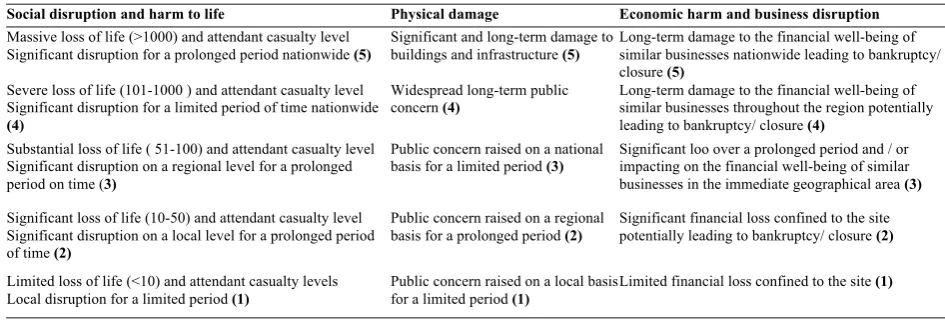
The impact rating is based on an overall ‘score’ (from 1 (‘very low’) to 5 (‘very high’)): end-users will have to identify which level of impact is relevant under each heading (Table 3).The user will then be provided with the breakdown showing the scores under each category (an example is shown in Figure 1).
Table 3 Impact assessment scoring system
Social disruption and harm to life Physical damage Economic harm and business disruption Massive loss of life (>1000) and attendant casualty level
Significant disruption for a prolonged period nationwide (5)
Significant and long-term damage to buildings and infrastructure (5)
Long-term damage to the financial well-being of similar businesses nationwide leading to bankruptcy/ closure (5)
Severe loss of life (101-1000 ) and attendant casualty level Significant disruption for a limited period of time nationwide (4)
Widespread long-term public concern (4)
Long-term damage to the financial well-being of similar businesses throughout the region potentially leading to bankruptcy/ closure (4)
Substantial loss of life ( 51-100) and attendant casualty level Significant disruption on a regional level for a prolonged period on time (3)
Public concern raised on a national basis for a limited period (3)
Significant loo over a prolonged period and / or impacting on the financial well-being of similar businesses in the immediate geographical area (3)
Significant loss of life (10-50) and attendant casualty level Significant disruption on a local level for a prolonged period of time (2)
Public concern raised on a regional basis for a prolonged period (2)
Significant financial loss confined to the site potentially leading to bankruptcy/ closure (2)
Limited loss of life (<10) and attendant casualty levels Local disruption for a limited period (1)
Public concern raised on a local basis for a limited period (1)
[image:5.544.33.506.389.549.2]Figure 1 Breakdown of the impact assessment scores
After completing this (and each following stages), the end-user will be presented with a set of outputs for each hazard/ threat identified. The outputs include hazard/ threat impact rating; the exemplar case studies illustrating good (i.e. where the hazard has been identified and the benefits of this) and bad (i.e. where a hazard was not identified) practice; the list of documents that illustrate how to identify potential threats and hazards; and a list of online based open access tools useful at this stage for the identified hazard/ threat.
3.2 Stage 2: Assess the vulnerability of the space to the identified threats/ hazards
At this stage the end-users identify how vulnerable their project site is based on its location and design. This will be done in two steps: 1) Identification of site vulnerabilities, and 2) Identification of design vulnerabilities.
The general idea behind the assessment of the site and design vulnerability is similar to the impact assessment: it will be based on the overall ‘scores’ (1 to 5), and the breakdown of the scores will also be provided. The categories against which the vulnerabilities will be scored are still under development, but preliminary categories include:
• Urban planning issues
• Architectural and industrial design issues • Site management and monitoring • Structural issues
• Material issues • Maintenance • Hazard mitigation • Emergency response • Stakeholder involvement
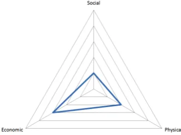
Overall vulnerability will be determined as a combination of a highest design vulnerability score and the highest site vulnerability score. The breakdown of vulnerabilities will be presented to an end user using a radar chart, example of which is given in Figure 2.
30 Ksenia Chmutina et al. / Procedia Economics and Finance 18 ( 2014 ) 25 – 32
Figure 2 Breakdown of the vulnerability assessment scores
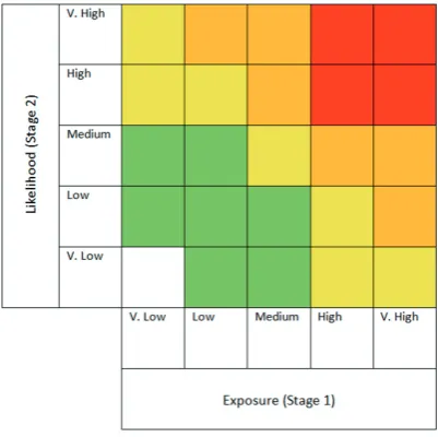
3.3 Stage 3: Determining risk
The objective of this stage is to demonstrate the overall magnitude of risk per hazard/ threat type. This stage is based on the information drawn from Stages 1 and 2: a combination of the exposure to and impact (consequences) of a hazard and the likelihood (change of something happening) of a hazard. The scores from Stages 1 and 2 provide information for the determination of the risk illustrated in the matrix (Figure 3). As in the previous stages, once the overall magnitude of the risk is identified, the end user will be presented with a set of outputs, including risk rating, case examples, and lists of relevant tools and documents.
[image:7.544.177.378.396.596.2]3.4Stages 4 and 5: Identifying ways to reduce the identified risks and prioritizing risk reduction measures
[image:8.544.70.482.162.266.2]The aim of this stage is to identify a course of action to address and treat the hazards/ threats and risks associated with them. Table 3 provides information on possible mitigation measures; based on the information in Table 4, suggestions of mitigation options appropriate for the identified hazard/ threat will be provided to the end-user. It is however important to bear in mind that the best options will invariably be context specific.
Table 4 Mitigation measures possible for each hazard/ threat
Risk reduction option/ Hazard Earthquake Crowded event Flood and storm Terrorism
Inherent safety N # # #
Prevention of hazard N # # #
Detection of hazard N # Y #
Control of hazard N # # #
Mitigation of hazard Y # Y #
Emergency response Y # Y #
‘Y’ –there are possibly a range of useful risk options available
‘#’ – some risk reduction options can be used but they are likely to be of only limited effectiveness ‘N’ –other than relocating the built asset there is little that can be done to reduce this hazard/ threat
Once the potential course of action has been identified, it is important to prioritize the most suitable options. Thus the objective of this stage is to assist in identifying the most suitable intervention for a given project. The prioritization will depend on a number of factors individual to each project; these include (and are not limited to):
• Cost vs. benefit of identified interventions • Corporate social responsibility
• Business continuity • Legal and statutory requirements • Technical and social feasibility
• Proportionality of identified interventions
• Complementarity with measures introduced to mitigate other hazards.
At this stage the end users will be provided with the cases where, with hindsight, the correct or wrong options have been chosen. Similarly to the previous stages, they will also be signposted to relevant tools and documents where appropriate. Once all the stages are completed, the end-user will receive a report, which incorporates the results of all the stages including the following:
• Relevant bad and good practice case examples
• Scores of the impact assessment and vulnerability assessment • Likelihood and exposure to risks
• List of documents relevant for this particular case (including overview of both structural and non-structural risk reduction measures)
• List of tools relevant for this particular case with the emphasis on the tools developed by the project partners.
It has to be emphasized that the report will not provide the answers but that is not the intention of the report. Rather it is the case that the report and the process will help in decision making by illustrating various examples and signposting to most suitable tools and documents that can assist the decision-making process.
4.Conclusions
32 Ksenia Chmutina et al. / Procedia Economics and Finance 18 ( 2014 ) 25 – 32
identifying vulnerabilities and improving urban spaces with respect to ‘security threats’. There is a great variety of open access web-based tools that cover various threats and hazards, and that are of potential use to stakeholders involved in the planning, design, construction operation and maintenance of urban spaces. However the majority of them are context-specific and can only provide partial information that can be useful in disaster risk management. DSSP partially fills this gap: it is a multi-hazard tool that covers both natural hazards and man-made threats and is aimed at different levels of stakeholders, from construction professionals to local authorities. In addition, it can be used in conjunction with international documents and guidelines
As demonstrated in this paper, the DSSP has the ability to engage the stakeholders who would not normally consider DRR and to aid their understanding of the vulnerabilities and design possibilities of the proposed site by allowing users to pursue decision-support scenarios of secure urban design and planning. Whilst DSSP cannot accurately predict every threat or hazard and provide the solution for the prevention or mitigation, it helps various stakeholders to consider prior knowledge of existing hazards and threats in a local context and to recognise that too often disasters occur because risk reduction measures have not been considered or undertaken.
Acknowledgements
This article has drawn from empirical work collected through the ‘Designing Safer Urban Spaces’ (DESURBS) project. This project has received funding from the European Union’s Seventh Framework Programme for research, technological development and demonstration under grant agreement no 261652. The authors would particularly like to acknowledge the role of IT Innovation (Southampton University) who were central to creating on online version of DSSP. The authors would also like to thanks all those who has provided valuable feedback on the ISR and DSSP.
References
Bosher, L. (ed), 2008. Hazards and the Built Environment: Attaining Built-in Resilience. Taylor and Francis, ISBN: 978-0-415-42730-2. Bosher L.S., 2014. ‘Built-in resilience’ through Disaster Risk Reduction: Operational issues’. Building Research & Information, 42 (2), xx-xx Bosher L., Dainty A.R.J., Carrillo, P. and Glass, J., 2007. Built-in resilience to disasters: a pre-emptive approach. Engineering, Construction and
Architectural Management, 14 (5), 434-46.
British Standards Institution, 2009. BS 31000:2009: Risk Management: Principles and Guidelines. London: British Standards Institution British Standards Institution, 2011. BS 31100:2011: Risk Management: Code of Practice and Guidance for the Implementation of BS ISO 31000.
London: British Standards Institution
Chmutina, K., Ganor, T. and Bosher, L., 2014. The role of urban design and planning in risk reduction: who should do what and when? Proceedings of ICE – Urban Design and Planning. DOI:10.1680/udap.13.00011
Coaffee, J., Murakami-Wood, D. and Rogers, P., 2008. The Everyday Resilience of the City: How Cities Respond to Terrorism and Disaster.b Palgrave/Macmillian
Fisher, J.F., Harre-Young S.N., and Bosher L.S., 2012. Understanding the relationship between resilience and sustainability: Emergency planning and design of urban space. In: Schrenk, M., Popovich, V.V. and Zeile, P. (eds.). Re-mixing the City- Towards Sustainability and Resilience? Proceedings of REAL CORP 2012, 14th-16th May 2012, Schwechat, Austria, pp. 965-973.
Keraminiyage, K.P., Amaratunga, R.D.G. and Haigh, R.P., 2007. Role of construction in managing disasters in developing economies. In: Annual Bank Conference on Developing Economics, The World Bank, Bled, Slovenia
Sutanta, H., Rajanifard, A. and Bishop, I.D., 2010. Integrating spatial planning and disaster risk reduction at the local level in the context of spatially enabled government. In: GSDI 12 World Conference: Realising Spatially Enabled Societies, Singapore.
UNISDR, 2011. Global assessment report on disaster risk reduction: revealing risk, redefining development. See http://www.preventionweb.net/english/hyogo/gar/2011/en/home/download.html (accessed 15/04/2014).
![Table 1 ISR stages description [after Bosher 2014]](https://thumb-us.123doks.com/thumbv2/123dok_us/9536655.458595/4.544.37.517.78.311/table-isr-stages-description-bosher.webp)