z
RESEARCH ARTICLE
COASTAL ZONE MANAGEMENT USING REMOTE SENSING AND GIS A CASE STUDY OF GOA
*Ramamohana Rao, P. and Suneetha, P.
Department of Geography, Andhra University, Visakhapatnam
ARTICLE INFO ABSTRACT
Goa an important beach resort on the west coast of India has a 101 km long coast line and receives around 23
million tourists every year. The beach shacks are regulated by the tourism department and in absence of proper
guidelines, the beaches are overcrowded due to the deck beds. Under the guise of renovation or repairs of existing
structures new hotels, shops and resorts have come into being. In spite of the stipulations of Coastal Regulation
Zone (CRZ) Act 1991 the local as well as people in power acquire lands and houses with sea view and violate
CRZ rules with impunity. Sectoral practices, partisan policies, unbalanced tourism, and absence of political will
have all contributed to the breaching of CRZ. Hence the present study is an attempt to map all the dwellings/ structures/buildings in the CRZ-III along the Goa coast. Remote sensing and GIS techniques have been effectively applied to achieve the objective. Analysis of spatial data reveasl that a large number of new structures / dwelling units have come up in CRZ –III after 1991. Calangute, Candolim and Anjuna Villages in North Goa and Palolem in South Goa are found to have more number of illegal constructions along the coast. Therefore these four villages have been chosen for the present study. Field survey conducted to obtain attribute information about legal permissions of the buildings substantiates the spatial analysis.
Copyright, IJCR, 2013, Academic Journals. All rights reserved.
INTRODUCTION
The coastal zone, which comprises land ward and sea ward fringes along the coast line are focus of increasing developmental activities (K.R.Srinivasan, 1996) Coastal zone in India is receiving an
increasing importance in view of its high productivity, rich eco-system, location of major urban and industrial centers and varied
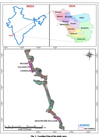
landscape of tourist interest. This dynamic zone in India is under constant pressure due to various developmental activities and intense urbanization. Rapidly increasing human population and industrial development along the coast have resulted in the degradation of coastal ecosystems. Goa State lies in the western part of India on the Arabian Sea front between latitudes 14°53’54’’N and 15°40’00’’N and longitudes 73°40’33’’E and 74°20’13’’E. (Fig.1) The State encompasses and area of 3,702 sq.km and has a coastline of 101km.The State consists of two districts, eleven talukas and 353 villages of which 37 are coastal villages. Goa is the prime tourist destination of India, and the tourism industry is growing rapidly. This growth is associated with land use changes such as buildings, industries, resorts, breakwater, minor harbors etc. especially along the coastal belt.
Concern about the impact of urban, industrial and tourism development on environment in the coastal regions has resulted in the formulation of special zoning guidelines. In accordance with Coastal Regulation Zone (CRZ) Act 1991 stipulations, Goa State Committee for Coastal Environment (GSCCE) was assigned the job of preparation of Coastal Zone Management plans classifying coastal stretches as CRZs. The plans prepared were approved by the Ministry of Environment and Forestry (MOEF) in September 1996 after incorporating the information on delineation of eco-sensitive areas along the coastal stretches of Goa generated by National Institute of Oceanography (NIO). This is the prevailing law that governs development activities along the coastal rivers and back water of Goa. It was amended twice in January and July, 1997 respectively. Since
*Corresponding author: [email protected]
the main purpose of CRZ notification was to control and minimize environmental damage to coastal ecosystem, the Goa State Committee for coastal environment was empowered to enforce the provision of the notification. Despite this, CRZ provision is blatantly violated in the State. The beach shacks are regulated by the tourism department and in the absence of proper guidelines, the beaches are crowded due to the deck beds which are encroaching the public access. Environmentalists allege that locals and people in power acquire lands and houses with sea view or river view and violate CRZ rules with impunity. Under the guise of renovation or repairs of existing structure, new hotels, shops, and resorts have come up. The beaches in Goa are overcrowded due to the deck beds.
Unfortunately not only individuals but also the Government agencies like as Goa State Urban Development Agency (DSUDA) has violated the CRZ rules. The nexus of violators is so strong that it is becoming increasingly difficult to define what is legal or illegal. Courts have intervened in coastal matters following complaints and petitions from citizens and NGO’s. Timely judicial intervention has, to some extent, preserved the sanctity of the coastal zones. This is the background for the present study that is aimed at mapping the CRZ-III and analyzing the spatial and temporal changes in it between 1991-2006. Several scientific studies have been carried out using satellite data in conjunction with GIS for addressing various issues related to coastal zone management. This is mainly because satellite remote sensing has the advantage of providing multi-spectral, synoptic information over large areas including inaccessible regions on a repetitive basis, which are the essential requirements for studying the coastal zone on an
integrated basis (Shailesh Nayak et al., 1999). Pramanik and Jabbar
(1990) used multi dated satellite data to monitor coastal zone dynamics in Bangladesh. Bharadwaj, (2002), Vimal GargandRitu Seth (2002) demonstrated the use of GIS and Remote Sensing techniques in development of Coastal Information System and its use as a regulating, management and decision making tool vis-à-vis development activities along the coastal stretches of India. Malthus and Mumby (2003) highlighted recent advances in knowledge of
ISSN: 0975-833X
Available online at http://www.journalcra.com
International Journal of Current Research
Vol. 5, Issue, 03, pp. 718-725, March,2013
INTERNATIONAL JOURNAL
OF CURRENT RESEARCH
Article History:
Received 26th
December, 2012 Received in revised form 18th
January, 2013
Accepted 11th
February, 2013
Published online 19th
March, 2013
Key words:
Coastal Regulation Zone, Coastal zone management, Goa,
remote sensing of the coastal zone.Cooper and Mckennna (2008) demonstrated the influences of administrative, legislative, societal and political factors in practical coastal management.
Data base and Methodology
The study is based on both primary data and secondary data. Secondary data includes satellite imagery (NRSA), Cadastral maps and High Tide Line (HTL) information (Directorate of State Land Records – DSLR). Whereas the primary data includes DGPS survey for obtaining Ground Control Points – GCPs (Table 1) and house hold survey for attribute information. Remote sensing and GIS technologies are used for mapping. Multi dated satellite data of the study area as specified below is used to map the CRZ-III.
1991-Russian Satellite Data - 2m. Resolution panchromatic 1998-IRS IC data - 5.8m. Panchromatic
[image:2.612.133.479.47.522.2]1999-IRS IC data - 5.8m. Panchromatic 2002-IRS IC data - 5.8m. Panchromatic 2003 – 2004 -QuickBird - 0.62m. Multi-spectral 2005-IKONOS - 1.0m. Multi-spectral
Table 1. Ground control points obtained through dgps survey
S.No Point Id Latitude Longitude
1 G1 15 32 42.548189 N 73 45 24.072700 E
2 G2 15 29 54.196711 N 73 46 21.534132 E
3 G7 15 33 28.782546 N 73 46 33.738312 E
4 G8 15 34 53.008898 N 73 44 22.043836 E
5 G14 15 36 19.584355 N 73 45 13.558025 E
6 G15 15 22 10.088758 N 73 50 8.010637 E
7 G20 15 24 30.587189 N 73 47 18.225300 E
8 G27 15 23 51.624801 N 73 50 44.778238 E
9 G32 15 23 38.909336 N 73 50 25.397449 E
10 G41 15 1 54.167216 N 74 1 59.494622 E
11 G42 14 59 33.102290 N 74 2 32.971678 E
The satellite images have been rectified using the GCPs in ERDAS Imagine software. High Tide Line is overlaid on each satellite image and buffers at 200m and 500m distance from the HTL are generated to
demarcate the CRZ-III. The CRZ-III area which is bounded between
the above two buffer lines is magnified sufficiently and interpreted visually. Each structure/building/ dwelling is identified and digitized.
[image:2.612.321.548.553.665.2]The methodology is repeated with each image to vectorise the structures and shape files have been created in ARC GIS Environment. All the shape files corresponding to the images of selected years of the study period are overlaid and integrated. The structures of each year are coded with unique colour and maps are generated for the four selected villages. Statistical information regarding the number of structures has been extracted from the corresponding attribute tables and tabulated. House hold survey has been conducted with the help of the above generated as well as the cadastral maps to identify the unauthorized structures in the CRZ-III and the attribute tables are edited with the same.
CRZ – III Norms as per Environment Protection ACT 1986
The Act defines CRZ-III as the zone between 200m and 500m from the High Tide Line. Much of Goa falls within CRZ – III and the norms for regulation of activities are as follows.
1. The area up to 200meters from the High Tide Line (HTL) is to be earmarked as ‘No Development Zone’. No construction shall be permitted within this zone except for repairs of existing authorized structures not exceeding existing FSI, existing plinth area and existing density, and for permissible activities under the notification including facilities essential for such activities. An authority designated by the State Government / Union Territory Administration may permit construction of facilities for water supply, drainage and sewerage for requirements of local inhabitants. However, the following uses may be permissible in this zone – agriculture, horticulture, gardens, pastures, parks, play fields, forestry and salt manufacture from sea water.
2. Development of vacant plots between 200 and 500 meters of High Tide Line in designated areas of CRZ-III with prior approval of Ministry of Environment and Forests (MEF) permitted for construction of hotels / beach resorts for temporary occupation of tourists / visitors subject to the conditions as stipulated in the guidelines at Annexure – II.
3. Construction / reconstruction of dwelling units between 200 and 500 meters of the High Tide Line (HTL) permitted so long it is within the ambit of traditional rights and customary uses such as existing fishing villages and gaothans. Building permission for such construction / reconstruction will be subject to the conditions that the total number of dwelling units shall not be more than twice the number of existing units; total covered area on all floors shall not exceed 33 percent of the plot size; the overall height of construction shall not exceed 9 meters and construction shall not be more than 2 floors ground floor plus one floor. Construction is allowed for permissible activities under the notification including facilities essential for such activities. An authority designated by State Government / Union Territory Administration may permit construction of public rains shelters, community toilets, water supply, drainage, sewerage, roads and bridges. The said authority may also permit construction of schools and dispensaries, for local inhabitants of the area, for those panchayats the major part of which falls within CRZ if no other area is available for construction of such facilities.
4. Reconstruction / alterations of an existing authorized building permitted subject to (i) to (iii) above.
DISCUSSION
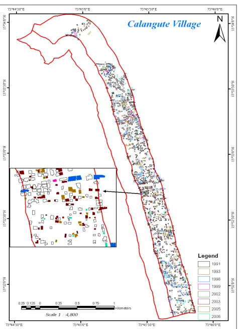
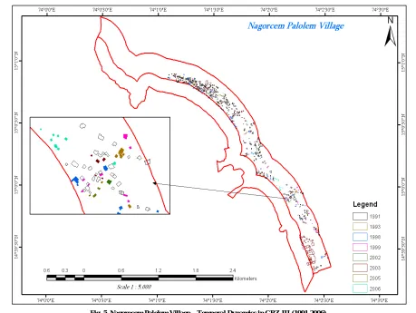
Of the 35 coastal villages of Goa four villages namely Anjuna, Calangute, Candolim and Nagorcem Palolem are selected for the present study as they show much growth in terms of number of structures. The temporal variations in structures/buildings/dwellings in the CRZ-III of the four selected villages are mapped separately at six different time points spread over a time period of fifteen years 1991-2006 and integrated and presented in Figures 2, 3, 4 and 5. New structures in each year are shown in different colours (polygons). The corresponding polygon attribute tables are consolidated and
presented in Table 2. The attribute tables of the selected villages have been examined carefully to analyze the temporal variations. Table 2 represents the temporal variations in the CRZ-III of the selected villages viz. Anjuna, Calangute, Candolim and Nagarcem Palolem. All the four villages have shown increase in number of structures during the study period. It is evident from the table that Calangute village has maximum increase of structures i.e. 685 during the study period followed by Candolim with 620 structures, Nagorcem Palolem with 385 and Calangute with 280 structures. All of them have recoded about 50 per cent increase in number of buildings during the study period i.e. 1991-2006. Anjuna has only 356 structures in the year 1991 and they increased to 438 in 1998 to 471 in 1999 to 475 in 2002 to 592 in 2003 to 621 in 2005 and to 636 in 2006. Totally 280 new structures were added during the study period i.e.1991-2006. Altogether 636 buildings/structures were identified on the 2006 satellite image.
In this village number of structures increased rapidly during 2002 to 2003 and 117 new structures were added during this particular year. Similarly in Calangute village there were only 826 structures in 1991 which increased to 1077 in 1998, to 1106 in 1999 to 1114 in 2002 to 1450 in 2003 to 1454 in 2005 and to 1511 in 2006. A total increase of 685 buildings/structures during the study period was observed and a total number of buildings/structures existed in the year 2006 were 1511. In Calangute village also the year 2002-03 recorded maximum increase, and 291 new buildings were added during this year. Where as in the case of Candolim village there were 620 structures in 1991 increased to 863 in 1998 to 896 in 1999 to 900 in 2002 to 1148 in 2003 to 1199 in 2005 and 1240 in 2006. Altogether there was an addition of 620 new buildings/ structures during the study period of which 248 structures were added in the year 2002-03 alone. Finally In Nagorcem Palolem there were 392 structures in 1991 increased to 484 in the year 1998 to 515 in 19991 to 516 in 2002 to 676 in 2003 to 750 and to 777 in 2006. The total increase in buildings during the study period was 385 and a total of 777 buildings/structures could be identified on 2006 image. In this village also the maximum increase is observed during 2002-03, 160 new buildings were added in this particular year and a considerable increase is recorded in the following year also. The specific reason for this substantial increase in structures during 2002-03 in all the villages in general is not known and the scope of the present study is limited to estimation of variations only. However interaction with the public during the field work reveals that most of the structures constructed during this particular period belong to NRIs.
Household Survey and Analysis
From 1999 no authority or Panchayat in the State has been permitted to approve new constructions or houses in the coastal villages that fall within 500 meters of the high Tide Line (HTL). The scope of the study includes identification of unauthorized constructions against CRZ norms. This requires collection of attribute information about the individual buildings / structures in CRZ-III, like type, ownership details, permissions for construction from appropriate authorities, number of floors plot area details of taxes paid etc. field surveys were carried out between May and September, 2007. The field survey was carried out using satellite imagery and maps on 1:1000 scale where in all the structures / dwelling units were marked and identified with unique identification numbers and distributed the proforma to each house marked on the satellite image. QuickBird satellite image of 2003 – 2004 was used for marking the houses and it was updated using survey data. Structures that came up after 2006 were marked during field surveys and they were also given identification numbers. The corresponding attribute tables are updated with all the information collected from different villages during the field survey based on their unique identification numbers. Table 3. gives information about the number of households surveyed with structured formats, the number of forms received with full or partial information, and details of construction approval. Out of 606 structures built in the CRZ-III in Anjuna village 73 per cent of the owners of the buildings
Fig. 3. Calangute Village – Temporal Dynamics in CRZ-III (1991-2006)
did not return the forms and only 27 per cent of the owners have responded and returned the forms. In the case of Calangute village out of 1435 owners only 17 per cent have responded positively and the remaining 83 per cent have not returned the forms. In the case of Candolim also the response is more or less similar. In contrast to the above villages in Nagorcem Palolem 99 per cent of the owners have responded positively and returned the forms. However the percentage of returned forms with full details is negligible in all the villages, varying from 0.3% to 0.7%. Analysis of the table reveals that only about 17 per cent of the total structures in Anjuna village have built with approval from one of the authority. In the case of Calangute village it is 16 per cent, in Candolim it is 35 per cent and in the case of
Nagorcem Palolem it is only 23 per cent. These percentages of structures which have all three permissions are as low as 1, 3.1, 7.4 and 1.3 respectively for Anjuna, Calangute, Condolim and Nagarcem Palolim. It is unfortunate that unauthorized structures outnumbered the legal constructions in all villages.
Conclusions
[image:7.612.76.535.51.396.2]Multi dated satellite imagery have been effectively used to identify and delineate the structures/dwelling units in the CRZ- III in four selected villages of Goa. Collection of ground control points (GCP’s) through Differential Global Positioning System (DGPS) survey helped in rectifying the satellite imagery. By overlying t he geo-
Fig. 5. Nagorecem Palolem Village – Temporal Dynamics in CRZ-III (1991-2006)
Table 2. Spatio-Temporal/Variations in the CRZ-III
S.No Village No Of Structures Difference
1991 1998 1999 2002 2003 2005 2006 (1991-2006)
1 Anjuna 356 438 471 475 592 621 636 280
2 Calangute 826 1077 1106 1114 1405 1454 1511 685
3 Candolim 620 863 896 900 1148 1199 1240 620
4 Nagorcem Palolem 392 484 515 516 676 750 777 385
Table 3. Unauthorized Structures Based on Survey
Sl.
No Village No. of
Struc-tures
No. of Respondents
* No. of Non-
Respondents Village
Panchayat Approved
Town Planning Approved
CRZ Approved
Percent of Approved
structures
Total % With full
details % Total %
1 Anjuna 606 164 27 2 0.3 442 72 58 38 6 17
2 Calangute 1435 245 17 5 0.3 1190 83 113 71 45 16
3 Candolim 1199 352 29 9 0.7 847 71 208 133 89 36
4 Nagorcem Palolem 777 771 99 5 0.6 6 1 118 51 10 23
*Includes owners who refused to accept the survey form/did not returned the forms
[image:7.612.66.549.509.586.2]referenced cadastral maps on satellite imagery the structures/ dwelling units could be mapped. The study estimated the number of structures / dwelling units that existed in 1991 and the add on structures in subsequent years upto 2006. Analysis of results showed that along the CRZ-III (i.e. between 200m and 500m from the HTL) a large number of new structures / dwelling units have come up after 1991, in all the selected villages. From 1991 to 2006, the estimated increases of structures are 280,685,620 and 385 in Anjuna, Calangute, Candolim and Nagorcem Palolem villages respectively. House hold field survey carried out to collect information on ownership details, plinth area, number of floors, permissions obtained from the competent authorities, taxes paid etc, showed very poor response. Therefore analysis on other parameters except for the building approval could not be carried out. Less than 1% of the owners responded with full details.
REFERENCES
Gita KewalramaniandMangala kokare 2008: Coastal Zone Dynamics and Regulation in a Metropolitan Region: A case study of Thane Creek EIA studies and Planning and perspectives Edt. Prof. S.Padmaja Vipla computer services, Nalla Kunta, Hyderabad, (2008, pp 181-204).
Cooper, J A G and J Mckenna (December 2008) working with natural processes: the challenge for coastal protection strategies. The Geographical Journal, Vol.174, No.4, pp 315-331.
Srinivasan, K. R., 1996: Sustainable Ocean Development and Coastal Zone Management. Indian Cartographer, Vol. 16, Dec, 1996, pp 161-163.
Nayak, S., Chauhan.P., Chauhan, H. B., Bahuguna, A. and Narendra nath, A. (1996). IRS 1C applications for coastal zone management. Current Science, 70 (7): 614-618.
Nayak, S., Bahuguna, A., Chauhan,p.,H.B and Rao, R.S. (1997).
Remote Sensing applications for coastal environment
management in India. MAEER’S MIT PUNE Journal, Special Issue on Coastal Environmental Management, 4 (15and16): 113-125.
Pramanik M A H and Jabbar M A (1990). Remote Sensing for Coastal zone Dynamics in Bangladesh. Asian Pacific Remote Sensing Journal, Vol. 2, No. 2.
Bhardwaj, R. K., Map India 2002 (National Hydrographic Officer, Dehradun) Application of GIS technology for Coastal Zone Management: a hydrographer perspective, http:// www. gisdevelopment.net/ proceedings/index.htm.
Shailesh Nayak et al 1999: Remote Sensing Applications for coast and ocean: Retrospective and perspective. Proc. of ISRS National Symposium on Remote Sensing Applications for Natural Resources, Jan 19-21, 1999, Bangalore, pp 418-432.
Vimal GargandRitu Seth, Map India, 2002 (WaterandPower
Consultancy Services (India) Ltd. Gurgaon, Haryana)
Development of GIS based Coastal Information System, http://www.gisdevelopment.net/proceedings/index.htm.
Wimon Pathtong (2006): Application of Remote Sensing and Geographical Information System (GIS) for Coastal Zone Management of Cochin coastal region, India. www.aars-acrs.org/acrs/proceeding/ACRS2006/Papers/G- 2_G14.pdf