www.ijres.org Volume 6 Issue 1 ǁ 1. 2018 ǁ PP. 13-20
Research On Road Detection Based On Improved RANSAC
Algorithm
1
Ming Xu,
2Juan Zhang,
3Zhijun Fang
*Shanghai University of Engineering Science, School of Electrical and Electronic Engineering, Long Teng Road, Shanghai, China, 201620
Corresponding Author: 2 Juan Zhang
ABSTRACT:
Road detection is one of the most important contents of automatic driving technology in recent years. In this paper, an improved RANSAC algorithm is proposed to detect boundaries of roads in unstructured environments, which is adapted to various unstructured scenes, such as uneven illumination and water stained pavements. The procedure of road detection includes 4 main parts: firstly, reducing the computational complexity by acquiring regions of interest. Secondly, 2-dimensional Otsu algorithm is used to segment the road from the background. Subsequently the whole road area is obtained by mathematical morphological operation and the method of getting the largest connected area. Edge detection and road boundaries extraction are used to get the information of road boundaries. Finally, an improved RANSAC algorithm is applied under the cubic curve model to fit the points of road boundaries. The experimental results show that the method can not only detect straight roads, but also apply to winding roads, and has good robustness and anti-interference to the road affected by shadows and water stains.Keyword:
Road detection, road boundaries extraction, image segmentation, RANSAC algorithm---Date of Submission:12-12-2017 Date of acceptance: 12-01-2018
---I.
INTRODUCTION
In recent years, with the popularity of private cars, road traffic accidents are becoming increasingly frequent. As a new technology in the new field, auxiliary driving technology has attracted much attention due to its extensive prospects. Vision-based road detection technology is one of the important elements of the advanced assistant driving system (ADAS), which is usually applied to the extraction of lane markings1-3. Since most lanes on the highway have clear lines and most of them are straight lines so that it is easy to detect the lanes and the lane detection technology for structured roads has reached a high level during recent years. However, due to inhomogeneous surface and curved shape of the roads, and the unstructured roads are vulnerable to light, shadow, water and other factors, which leads to poor detection performance. Therefore, the unstructured road detection technology is still in the research period.Taking the characteristics of various road models and the actual needs of road detection into consideration, we propose a fast and efficient road detection algorithm that can detect the unstructured road affected by complex environments. The procedure of the proposed method is as follows. Firstly, region of interest (ROI) is obtained to preclude interference of the environments. Then 2-dimentional Otsu algorithm is used to segment the ROI image. After a series of procedures, such as mathematical morphological operation and the largest connected area extraction, a complete road area is acquired, edge detection and road boundaries extraction are also used to get the information of boundaries of the road. Ultimately, an improved RANSAC algorithm is adopted under the cubic model to fit the points of road boundaries.The rest of the paper is organized as follows. Sec. 2 introduces related works on road lane detection in recent years. Sec. 3 describes the proposed detection method on unstructured road. Sec. 4 shows experimental results under different scenes. The conclusion and further research suggestion demonstrate in Sec. 5.
II.
RELATED WORKS
For an autonomous driving system, it is critical to detect and track the lane markings or road boundaries under various environmental conditions, which is also significant for the navigation and departure warning4,5. In this section, we illustrate some documents related to the research of road detection in recent years.
At present, domestic and foreign research scholars have presented plenty of methods used to detect the road6,7.
These algorithms can be roughly divided into three types: feature-based algorithm8-11, model-based
algorithm12-14and neural network based algorithm15-18.
detection of the road area. Ying Z, Li G and Tan G8proposed an illumination-robust approach for feature-based
road detection. They modified saturation during preprocessing so as to diminish cast shadows, after acquiring ROI, an improved feature-based method is employed to identify lane-markings from the shadows.
Model-based method greatly depends on the setting of model parameters to acquire the boundaries of the road. Due to the reality of the road model is a linear or curved shape, it is easy to fit the road boundaries with Hough transform and Least Square Method. However, both of the methods have difficult in adjusting to the continuous changing environment. Shikun Xu et al.12obtain a “bird’s eye view” of the road by using IPM
transform. Subsequently, an improved RANSAC algorithm is implemented to fit hyperbolic model, which ensures the high robustness and efficiency of the algorithm.
Neural network based approach is an increasingly popular method during these 5 years. This method deals with data collected and learn features that commonly exist in images of the data set. After finishing the procedure of training, the system can easily recognize and classify what they are once you input wanted data. However, this method has its shortcomings that a quite large data set is needed and a long-term training process is required. Junyu Gao et al.16proposed a siamesed fully convolutional network based on VGG-net architecture,
which is able to consider RGB-channel, semantic contour and location prior simultaneously to segment road region elaborately.
Recent years, many researchers have been considering combine features with neural network to solve problems. Wenli He et al.19developed a robust feature fusion framework, which is combined with superpixel
feature and 3D feature extracted from stereo images. Then a neural network classifier is applied to judge if a superpixel is a road region or not. Furthermore, there are some documents integrating method based on features into model-based algorithm. Liying Wu and Qiang Yu20 present an approach based on gray feature and road
model to process the road images. 2-D maximum entropy is used to segment the road and fuzzy entropy is utilized to optimize segmentation results according to the gray feature of the images. And an improved method of fitting is put forward on the basis of least squares curve fitting.
III.
PROPOSED METHODS
The proposed method includes four main parts: ROI selection, road image segmentation, road boundaries extraction and road boundaries modeling and fitting. Firstly, selecting a ROI in order to reduce the computational complexity as well as exclude part of interference. Secondly, segmentation algorithm based on 2-D Otsu is used to obtain a binary road image separated from the non-road area. Thirdly, mathematical morphological open and close operation to fill the holes in the image, and the largest connected area is extracted from the image, which is considered as the entire road area. Besides, road boundaries are acquired by edge detection operator and the method of road boundaries extraction. Finally, an improved RANSAC algorithm under the cubic curve model is applied to fit the points of boundaries.
3.1 Region of Interest Selection
As we know, the camera is usually placed on the top of a car, the road images it takes usually contain some irrelevant information such as the sky. So some articles21,22mentioned that they set a ROI manually which
3.2 Road Segmentation Based on 2-Dimentional Otsu Algorithm
Otsu is a typical dynamic threshold method. The method takes the maximum variance of the target and the background as the criterion in choosing a threshold, and takes the gray value when the maximum variance is generated as the overall segmentation threshold of the image so as to achieve the purpose of region segmentation. Compared to Otsu, 2-D Otsu considers both gray information of the image and spatial neighborhood information between pixels, which also has the advantage of higher noise immunity24. The
concrete steps are as follows:
1) Get the 2-dimentional histogramhijaccording to an image (size:M N ) whose gray level is Land neighborhood smoothing imageg, hijstands for the image whose original image with a gray level of i and a smoothing image with a gray level of j. So the joint probability of i andj is Pij hij/ (M N ).
2) For the 2-dimentional histogram shown in Fig. 4,t represents gray levels of the image, s stands for gray mean value of pixel neighborhood. Because of the self-similarity of the feature of object and background, which will be located in the area I and area III (presume that they are background and object respectively) so that we will obtain the possibility of background0and object1.
-1 -1
0 1
0 0 s 1 1
s t L L
ij ij
i j i j t
P
P
,
And the mean value of gray image of the background and object are:
0 0s, 0 0 0
0 0 0 0
(
)
T(
s t/ ,
s t/ )
Tt ij ij
i j i j
u
u u
iP
jP
1 1 1 1
1 1s, 1 1 1
s 1 1 s 1 1
(
)
T(
L L/ ,
L L/ )
Tt ij ij
i j t i j t
u
u u
iP
jP
The mean value of the whole gray image is:
1 1 1 1 ,
0 0 0 0
(
)
T(
L L,
L L)
TT Ti Tj ij ij
i j i j
u
u u
iP
jP
3) Set
( , )
s t
as the threshold of segmentation that meets the demand of the largest variance between classes.2 2
0 0 1 1 ,
arg max ( , )
B(
T)
(
T)
s t
S s t
u u
u u
BS
is the matrix which is used to denotes the degree of segmentation between object and background. The final segmentation threshold is taken as the parameter of adaptive threshold segmentation, and the gray image of ROI is segmented to obtain a binary image which separates the road area from the non-road area.3.3 Road Boundaries Extraction
This section focuses on further optimization of the road image after segmentation, to make the edge of the road clearer and more conducive to road fitting. The main steps of road boundaries extraction in this paper are as follows:
1. Mathematical morphology operation: Due to the large amount of irrelevant noise in the vicinity of unstructured road, which may influence the acquisition of road area. Therefore, this paper uses morphological open and close operations to eliminate holes as well as smooth the road boundaries.
2. Road area acquisition: In this paper, the method of obtaining the largest connected domain is adopted. After marking each connected domain, the area of each region is calculated and the area with the largest proportion is selected as the road area.
3. Edge detection: This paper uses Sobel operator for edge detection. Sobel operator has a smoothing effect on the noise, which provides more accurate edge direction information. The information of road boundaries is gotten after the edge detection.
4. Road Boundaries Extraction: Since two sides of the boundaries cannot be fitted on one map at the
same time, the left and right boundaries should be separated and fitted in turn. The image after the edge detection is a binary image E x y( , ) containing only two types of pixels (0/1).
1,
( , )
0,
points of boundaries
E x y
else
The method of scanning seeks points that pixel are 1 in the image from the top to the bottom sequentially. If there are no less than 2 points whose pixel are 1 in a row, put the first point into an image1, and store the last point into another image2(Both 1 and 2 are images have the same size as ROI and store zeros only). At last, we will obtain an image1with points of the left boundary only, and another image2with points of the right boundary only.
1 2
,
:
,
theleft boundary
road boundaries
the right boundary
3.4 Road Boundaries Modeling and Fitting
3.4.1Road boundaries modeling
The commonly used road fitting model are linear model25, quadratic curve model26and cubic curve
model27and so on. The method based on the linear model is simple and has good real-time performance, but the
disadvantage is that curved road cannot be fitted. The quadratic curve model extends the linear model and solves the problem that linear model cannot fit the curve road without increasing the complexity of the algorithm. However, like the linear model, the model has the problem of lower fitting accuracy due to disturbances of local interference points. The cubic curve model is suitable for the road whose curvature changes rapidly, but the model needs more calculations and produces poor real-time performance. By summarizing the advantages and disadvantages of these models, this paper chooses the cubic curve model M as the shape of unstructured road changes fast, and the model formula shows in①:
3 2
y ax bx cx d
①3.4.2Road boundaries fitting
Hough transform used to fit the line on structured roads as the lanes on the structured roads are clear and usually linear lines. Fitting the road boundaries by Least Squares Method has the advantages of convenient calculation and good fitting effect. However, the method is more sensitive to outliers. When there are some outliers, it will lead to the deviation of the curve model. The RANSAC algorithm becomes widely used because it only fits the key points that are suitable for the pre-set model and is insensitive to outliers. Nevertheless, its disadvantages are also obvious, that is, we are supposed to set the number of iterations and a threshold related to the problem manually, which is hard to choose. In order to solve the problems above, this paper presents a method based on an improved RANSAC (RANdom SAmple Consensus) algorithm to fit the road boundaries. For fitting the left boundary, for example, the specific steps are as follows:
(1). Acquire the whole sample points. Take one point for every 2 lines, the point set obtained is the whole sample points.
(2). Divide all the sample points into 4 equal parts from top to bottom, and randomly select a sample point from each sample subset as the feature point. Assume the coordinate of the 4 feature points are
1 1 2 2 3 3 4 4
( , ),( , ),( , ),( , )x y x y x y x y , if they are on the curve, [ , , , ]a b c d can be solved by following equations②,
which is the coefficients of cubic curve model.
3 2
1 1 1 1
3 2
2 2 2 2
3 2
3 3 3 3
3 2
4 4 4 4
ax bx cx d y
ax bx cx d y
ax bx cx d y
ax bx cx d y
②(3). Calculate the shortest distance from the entire sample point to the curve model, which is accomplished by the Least Square Method. If a sample point satisfies the inequality③, it is treated as the interior point of the
curve. Continue to calculate the distance from remaining sample points to the curve model that is less than the threshold of the number of tolerances, counting the total number '( ' )t t t of all the inliers under this curve model.
3 2
|
i i i i|
(4). Set the number of iterationskand repeat steps②and③above until the loop ends, and we will obtain
k
curve models.(5). Specify the curve model with the largest number 't of inliers as the optimal curve model M*, if the coefficients of the optimal curve model is [ *, *, *, *]a b c d , the model formula shown in ④ is the final curve
equation of the road boundary line:
3 2
*
*
*
*
y a x b x c x d
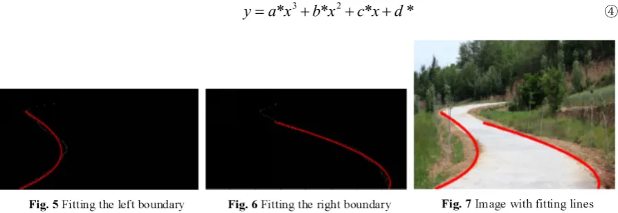
④The Fig. 5 and Fig. 6 above show fitting boundaries according to their points, and Fig. 7 displays the result on the original image. Compared to basic RANSAC algorithm, the improved RANSAC algorithm proposed in this paper is based on the understanding of prior knowledge of the road environment and selects various parameters suitable for unstructured environments. The concrete improvements are as follows:
1. Picking points at the same interval without affecting the whole boundaries points.
2. In order to reduce the randomness of the RANSAC algorithm, dividing the sample points into 4 equal parts, a random point is selected from each part.
3. The threshold is set to prevent inliers from being affected. Usually the threshold is hard to determine, but the points of road boundaries are often close to each other, so it is easy to set a fixed threshold and =10 in this paper.
4. Number of iterationskis another value that needs to be improved. Some articles12,28directly set the
number as 100 for the reason that multiple iterations are needed to ensure its accuracy. As we assume that the more points we have, the more iterations we need relatively, and vice versa. However, for some boundaries that have few outliers, finding the optimal curve model needs only several times iterations. So we set the number of iterations equals to a half of total number of sample points in order to select the iterations automatically and dynamically. Due to the procedure of ROI selection, the total number of sample points are generally no more than 100.
With the enhanced steps above, the improved RANSAC algorithm costs less consumption of time under the premise of fitting road boundaries.
VI. EXPERIMENTAL RESULTS
In order to verify the validity of the proposed algorithm, the author has conducted extensive tests on pictures with unstructured roads. Experiments were conducted in Windows 7 Ultimate system, and the MATLAB R2014a is used as a development tool. The size of test images are 400 300 . In this paper, two groups of experiments are complemented to support the validation of our proposed method.
4.1 Experimental Results of Various Algorithms
(a) (b) (c) (d)
Fig. 8experimental results of various algorithms
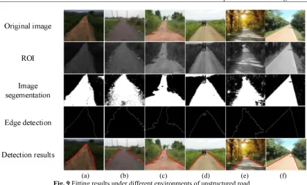
4.2 Fitting Results under Different Environments of Unstructured Road
The following Fig. 9 shows the detection results processed by our method in different scenarios, such as light, shadow, mud, night, water and obstacles. Among these pictures, original images are shown in the 1st
row; the gray images of ROI are presented in the 2ndrow; binary images processed by 2-dimentional Otsu are in
the 3th row; images after edge detection displayed in the 4th row; the 5th row shows detection results after
improved RANSAC algorithm.
Fig. 9(a) shows the results of an image with low-illumination after processed by our method for each step. After the procedure of segmentation and edge detection, the image with complete boundaries is gotten. The result in the 5throw shows great fitting effects by improved RANSAC algorithm. Fig. 9(b) are images with the
defect that original image has indistinct boundaries and its results after each detection results. As depicted in the 3rdrow, the binary image after segmentation has a great deal of noises, which may have a bad influence on
fitting the road boundaries. But the edge detection revised the road edges, and therefore an image with great fitting lines is acquired. Fig. 9(c) describes an image with water stained and its results after detection of each step. As we can see clearly that the image in the 4th row has a higher rate of false detection of the road
boundaries. However, the 5throw indicates that the fitting procedure rules out false points of road boundaries
and achieves favorable result. Fig. 9(d) reveals a road image with obstacles on the road and its detection results for every step. As the obstacle has similar gray levels, the segmentation step cannot tell obstacle and background apart. Edge detection removes some interference and fitting procedure ultimately contributes road boundaries roughly. Fig. 9(e) shows experimental results of the image with extensive shadow. Moreover, the image in the 5throw of Fig. 9(e) demonstrates our proposed method comes out favorable results even if in intense shadow.
(a) (b) (c) (d) (e) (f)
Fig. 9Fitting results under different environments of unstructured road
VII. CONCLUSION AND FUTURE WORK
In this paper, we present an improved RANSASC algorithm to solve the problems of road detection on unstructured road. The proposed method needs preprossing procedures, such as ROI selection and 2-D Otsu algorithm to segment the road from the non-road areas. Mathematical morphological operation, the method of attaining the largest connected domain, edge detection and road boundaries extraction are used to extract the points of road boundaries. We propose an improved RANSAC algorithm under cubic curve model to fit points of road boundaries. The method gains promising results in various environments. In the future, we will be dedicated to deducing more effective and efficient methods to further improve the detection results and try to track road boundaries in the real world on a video.
REFERENCE
[1]. F C and X.J L. “Review of Lane Detection Based on Monocular Vision,” SCIENTIFIC CHINESE, 15 (2017).
[2]. Fritsch J, Kuhnl T, Geiger A. “A new performance measure and evaluation benchmark for road detection algorithms,” in Proc. of International IEEE Conference on Intelligent Transportation Systems. IEEE, 1693-1700 (2014).
[3]. Singh et al. “A Survey on Various Lane Detection Techniques,” International Journal of Advanced Research in Computer Science and Software Engineering 5(6), pp. 342-347 (2015).
[4]. A. Narayan et al. “A dynamic colour perception system for autonomous robot navigation on unmarked roads”, Neurocomputing (2017)
[5]. Jiang H, Xiao Y, Zhang Y, et al. “Curve path detection of unstructured roads for the outdoor robot navigation,” Mathematical & Computer Modelling, 58(3–4):536-544 (2013).
[6]. Hillel A B, Lerner R, Dan L, et al. “Recent progress in road and lane detection: a survey,” Machine Vision & Applications, 25(3), 727-745 (2014).
[7]. Narote S P, Bhujbal P N, Narote A S, et al. “A Review of Recent Advances in Lane Detection and Departure Warning System,” Pattern Recognition (2017).
[8]. Ying Z, Li G, Tan G. “An Illumination-Robust Approach for Feature-Based Road Detection,” IEEE International Symposium on Multimedia. IEEE, pp. 278-281 (2016).
[9]. Li Z Q, Ma H M, Liu Z Y. “Road Lane Detection with Gabor Filters,” International Conference on Information System and Artificial Intelligence. IEEE, pp. 436-440 (2017).
[10]. Xiao L, Dai B, Liu D, et al. “Monocular Road Detection Using Structured Random Forest,” International Journal of Advanced Robotic Systems, 13(101) (2016).
[11]. Wu M, Lam S K, Srikanthan T. “Nonparametric Technique Based High-Speed Road Surface Detection,” IEEE Transactions on Intelligent Transportation Systems, 16(2):874-884 (2015).
[12]. Xu S, Ye P, Han S, et al. “Road lane modeling based on RANSAC algorithm and hyperbolic model,” International Conference on Systems and Informatics. IEEE, 97-101 (2017).
[13]. Kellner M, Hofmann U, Bouzouraa M E, et al. “Multi-cue, Model-Based Detection and Mapping of Road Curb Features Using Stereo Vision,” International Conference on Intelligent Transportation Systems. IEEE, pp. 1221-1228 (2015).
[14]. Xiaoyun W, Y.ongzhong W. “A Lane Detection Algorithm Based on Linear-hyperbola Model,” Journal of Hangzhou Dianzi University, 30(6):64-67 (2010).
[15]. Xia S, Zhang J, Lu K, et al. “Road detection via unsupervised feature learning,” IEEE International Conference on Image and Vision Computing New Zealand. IEEE, pp.1-6 (2016).
detection,” IEEE International Conference on Robotics and Automation. IEEE, pp. 219-224 (2017).
[17]. Caltagirone L, Scheidegger S, Svensson L, et al. “Fast LIDAR-based Road Detection Using Fully Convolutional Neural Networks,” Intelligent Vehicles Symposium. IEEE (2017).
[18]. Mendes C C T, Frémont V, Wolf D F. “Exploiting fully convolutional neural networks for fast road detection,” IEEE International Conference on Robotics and Automation. IEEE (2016).
[19]. He W, Cai G, Zhong Z, et al. “Feature++: Cross dimension feature fusion for road detection,” IEEE International Conference on Acoustics, Speech and Signal Processing. IEEE, pp. 1662-1666 (2017).
[20]. Liying W, Qiang Y. “A Fast and Accurate Detection Method of Unstructured Road,” Computer Simulation. 33(9):174-178 (2016). [21]. Yang Q, Fan S, Wang L, et al. “Road detection by RANSAC on randomly sampled patches with slanted plane prior,” IEEE,
International Conference on Signal Processing. IEEE, pp: 929-933 (2017).
[22]. Li W, Gong X, Wang Y, et al. “A lane marking detection and tracking algorithm based on sub-regions,” International Conference on Informative and Cybernetics for Computational Social Systems. IEEE, pp. 68-73 (2014).
[23]. Son J, Yoo H, Kim S, et al. “Real-time illumination invariant lane detection for lane departure warning system,” Expert Systems with Applications , 42(4), pp: 1816-1824 (2015).
[24]. YQ Wang, et al. “Unstructured road detection and tracking based on monocular vision,” Journal of Harbin Engineering UniversityJournal of Harbin Engineering University, 32(3):334-339 (2011).
[25]. Xiaohang L, Jia G, et al. “Improved algorithm of road detection based on Hough transform,” Journal of Applied Optics, 37(2):229-234 (2016).
[26]. Dorj B, Lee D J. “A Precise Lane Detection Algorithm Based on Top View Image Transformation and Least-Square Approaches,” Journal of Sensors, pp:1-13 (2016).
[27]. Berriel R F, Aguiar E D, Filho V V D S, et al. “A Particle Filter-Based Lane Marker Tracking Approach Using a Cubic Spline Model,” Graphics, Patterns and Images. IEEE, pp: 149-156 (2015).
[28]. Zhu S, Wang J, Yu T, et al. “A method of lane detection and tracking for expressway based on RANSAC,” International Conference on Image, Vision and Computing. IEEE (2017).