https://doi.org/10.5194/tc-12-627-2018
© Author(s) 2018. This work is distributed under the Creative Commons Attribution 4.0 License.
Brief Communication: Mapping river ice using drones and
structure from motion
Knut Alfredsen1, Christian Haas2, Jeffrey A. Tuhtan3, and Peggy Zinke1
1Department of Civil and Environmental Engineering, Norwegian University of Science and Technology,
7491 Trondheim, Norway
2I AM HYDRO GmbH, Märtishofweg 2, 78112 St. Georgen, Germany 3Centre for Biorobotics, Tallinn University of Technology, Tallinn, Estonia
Correspondence:Knut Alfredsen ([email protected]) Received: 18 September 2017 – Discussion started: 9 October 2017
Revised: 29 December 2017 – Accepted: 17 January 2018 – Published: 21 February 2018
Abstract.In cold climate regions, the formation and break-up of river ice is important for river morphology, winter wa-ter supply, and riparian and instream ecology as well as for hydraulic engineering. Data on river ice is therefore signif-icant, both to understand river ice processes directly and to assess ice effects on other systems. Ice measurement is com-plicated due to difficult site access, the inherent complexity of ice formations, and the potential danger involved in carry-ing out on-ice measurements. Remote senscarry-ing methods are therefore highly useful, and data from satellite-based sen-sors and, increasingly, aerial and terrestrial imagery are cur-rently applied. Access to low cost drone systems with quality cameras and structure from motion software opens up a new possibility for mapping complex ice formations. Through this method, a georeferenced surface model can be built and data on ice thickness, spatial distribution, and volume can be extracted without accessing the ice, and with considerably fewer measurement efforts compared to traditional surveying methods. A methodology applied to ice mapping is outlined here, and examples are shown of how to successfully derive quantitative data on ice processes.
1 Introduction
River ice is a critical part of the cryosphere (Brooks et al., 2013), and ice formation has implications for river geomor-phology, instream and riparian ecology, winter water sup-plies and for hydraulic engineering in cold climates. Phys-ically monitoring and mapping ice is methodologPhys-ically
chal-lenging, as accessing river ice is difficult and potentially dan-gerous. Therefore, remote sensing methods are applied to as-sess ice in rivers and a number of examples of this exist in literature. Chu and Lindenschmidt (2016) integrated optical (MODIS) and radar (RADARSAT-2) satellite data to assess freeze-up, break-up, and ice types in the Slave river, Canada. They also used aerial- and terrestrial imagery to validate the satellite data, and found good agreement on break-up and freeze-up dates. Mermoz et al. (2014) demonstrated how ice thickness could be derived from RADARSAT-2 data for three rivers in Canada. Beltaos and Kääb (2014) used successive satellite images to assess the flow velocity and discharge dur-ing ice break-up, illustratdur-ing the ability of usdur-ing remote sens-ing for studysens-ing ice process dynamics. Ansari et al. (2017) developed algorithms to automatically derive ice phenology data from bankside photography, and produced time series of these ice data for the lower Nelson River, Canada. Most satellite-based approaches described in the literature are ap-plied to large rivers and may not apply to smaller rivers and streams due to the coarse resolution of the satellite imagery. Remote sensing methods are therefore needed to monitor ice formation in smaller rivers. Further work is also needed to move from a qualitative evaluation of ice (focussing on ice types and presence or non-presence of ice) towards a quan-tification of ice volumes and the spatial distribution.
628 K. Alfredsen et al.: Brief Communication: Mapping river ice
by aerial photography. Ground control points can be used to georeference the point cloud and aerial images generated by the drone, in order to develop digital elevation models of high accuracy and resolution. Additionally, surface texture may be derived and overlaid on the surface models, and derived geo-referenced orthophoto mosaics to provide an accurate aerial image of the study object. SfM has shown great potential within geosciences where detailed digital models are often needed (Westoby et al., 2012; Smith et al., 2016), and the method has been applied, for example to studies on river habitat and hydromorphology (Woodget et al., 2017), erosion and sedimentation studies (Smith and Vericat, 2015), and for grain size classification (Vasquez-Tarrio et al., 2017; Arif et al., 2016). Within the cryospheric sciences this method has been used in the study of glaciers (Ryan et al., 2015) and in the study of snow accumulation (Nolan et al., 2015).
Combining a drone with SfM may be an efficient tool for mapping ice in rivers of various sizes, with the added advan-tage of also being able to cover small streams. This approach may enable detection of ice jams formed during ice runs, and anchor ice dams formed during freeze-up. These dynamic ice forms are difficult and time consuming (sometimes impossi-ble) to map using traditional methods, but are important to many ice assessments. Ice break-up and associated jams can cause erosion and flooding, and thus severe damage to in-frastructure and the riverine flora and fauna (Beltaos, 1995; Prowse and Culp, 2003). Anchor ice dams control the freeze-up process in small rivers and streams, and are thus important for understanding winter conditions in such streams (Stickler et al., 2010; Turcotte and Morse, 2011). A possible drawback with the use of small drones as employed here their is lim-ited flight distance (typically 1000–1300 m) and battery life in cold conditions.
In this brief communication, we outline the process of mapping river ice with a common, consumer-grade drone combined with commercial SfM software. Furthermore, we use the method to map the remnant of a stranded ice jam in one river section another river section with anchor ice dams. Cross sections and the volume of the ice run are computed from the mapped data, and the location and size of the anchor ice dams are estimated. Since these quantitative data are not commonly produced due to the difficulties associated with traditional field measurements, the application of the method presented has the potential to increase the amount and quality of data available. This may further improve our understand-ing of ice processes that form the foundation for modellunderstand-ing and practical assessments of ice impacts to constructed and natural environments.
2 Materials and methods 2.1 Study site
Our two study sites are located at the river Gaula (63.06◦N, 10.29◦E) and the tributary Sokna (62.98◦N, 10.22◦E) south of Trondheim, Norway. We mapped a stranded part of an ice run that took place in December 2016 at the Gaula site close to Haga bridge and at the Sokna site we mapped a section of the river with several broken anchor ice dams. The drone flight was carried out in February 2017 under sparsely clouded conditions with low wind velocities. The length of the reaches mapped are 350 and 200 m for Gaula and Sokna, respectively. During the measurements, the dis-charge in Gaula (at the Gaulfoss gauge) was approximately 20 m3s−1and in Sokna (at the Hugdal bridge gauge) approx-imately 3.5 m3s−1. These rates correspond to 28 % of the mean annual flow. The Gaula site is about 75 m wide, and the water flows mainly over a bed of coarse gravel and small cobbles. At the location where the ice jam formed, the river narrows and the flow changes from a section with fast rif-fles to a deeper pool area. The Sokna site is steep (1/100), the bed consist of large cobbles and boulders, and the river is characterised by short pools interspersed with drops and fast riffles/rapids. The width of the reach is around 18 m. 2.2 Data collection and processing
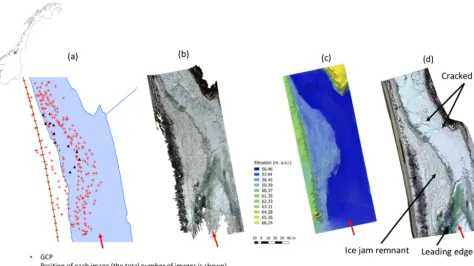
Figure 1.Stages of the process of mapping the Gaula site. Panel (a)shows the position of the drone for each image (crosses) and the ground control points (triangles) overlaid on a digital map of the river section. Panel(b)shows the dense point cloud for the same reach after processing the aerial imagery. Panel(c)shows the georeferenced digital surface model based on the point cloud. Panel(d)shows an orthophoto mosaic of the reach, showing both the ice jam to the left and an ice cover at different stages of formation. The red arrow shows the flow direction.
All GCPs and post-processing control points were measured during the drone flights. The GCPs and post- processing con-trol points were surveyed using a Leica Viva RTK-GPS (spa-tial accuracy of 1–2 cm), and they consisted of custom-made numbered markers (25×25 cm) made of heavy red tarpaulin that were clearly visible on the drone images. GCPs were spread out over the measurement domains as much as condi-tions allowed, but only one bank was accessible to us at the Sokna site. At the Gaula site 11 GCPs were measured on the ice surface for georeferencing, and another 9 control points were measured to provide a simple control of accuracy of the surface model after processing. At the Sokna site, 9 GCPs were measured on the river bank since it was not possible to access the ice surface for safety reasons. The number of GCPs is based on previous experience of the necessary num-ber of points to develop an accurate point cloud and surface model. The number of points is also in correspondence with Turner et al. (2012) who found similar results using 10 and 20 GCPs. The captured images and GCPs were processed us-ing Agisoft Photoscan Pro version 1.3.0 (www.agisoft.com) into a georeferenced point cloud using the SfM workflow de-scribed by the following steps:
1. Photos were aligned and images with a quality index greater than 0.8 were included in the point cloud
gen-eration. The quality index is computed by Agisoft Pho-toscan based on an evaluation of image sharpness, and experience shows that it is related to the spatial distri-bution of contrast in the images. The camera models were optimized and points with a RMS re-projection er-ror of less than 0.2 were deleted from the cloud. Af-terwards, the modelled camera positions and orienta-tions were optimized again to improve the initial cam-era alignments, which were estimated by the software, based on common features between pairs of images. 2. GCPs and control points were imported to Photoscan
and markers were manually identified and linked to the GCP. Each marker was identified on a minimum of three images before the georeferencing parameters were re-calculated. In the Sokna case, the GCP showed an er-ror that was considered too large, and this point was re-moved. The camera models were optimized once more and georeferenced clouds were generated.
630 K. Alfredsen et al.: Brief Communication: Mapping river ice
Table 1.Root mean square error computed from GCP and control points. The error is reported for the combination ofx,y,zand error for each coordinate.
Measurement No. of Mean RMS Min RMSE Max RMS Long. Lat. Alt. points combined (m) combined (m) combined (m) (m) (m) (m)
Gaula GCP 11 0.071 0.027 0.098 0.048 0.051 0.013
Gaula control 9 0.102 0.008 0.224 0.067 0.051 0.070
Sokna GCP 9 0.06 0.012 0.102 0.047 0.031 0.022
Figure 1 shows the locations of the camera positions and the GCPs, the generated point cloud, the surface model and an orthophoto mosaic for the Gaula site. To extract cross-sections and analyse the surface model generated in Photo-scan, data were exported to ArcMap 10.5 (www.esri.com), and the tools in the 3-D analyst package were used to ex-tract data from the surface model. The ground elevation under the ice jam in Gaula was taken from the 1 m Nor-wegian DEM provided by the NorNor-wegian mapping agency (www.hoydedata.no).
3 Results
The quality of the georeferencing and post-processing con-trol points was assessed using the root mean square error (RMSE) of the combined x,y, zcoordinates computed in Photoscan. Given the low amount of errors shown in Ta-ble 1, the accuracy of the digital elevation model is consid-ered good and ice features may be derived with high preci-sion. A further comparison of the georeferenced images with features on the digital map of the area shows good correspon-dence between the features georeferenced in the images and the same features on the digital maps.
Figure 1d shows the orthophoto mosaic of the Gaula site, the extent of the ice jam, and the directional stacking of the ice floes accumulated in the jam. The formation of the ice cover on the river section outside the ice jam is also visible, and the pattern of a retrograde build-up of ice with the lead-ing edge is clearly identifiable in the lower left edge of the picture. Furthermore, cracking and some shoving of the ice cover outside the ice jam can be seen, giving a clear indica-tion of the mechanisms that form the ice cover on this reach of the river.
As shown in Fig. 2, cross-sections of ice jams were ex-tracted from a combination of the SfM-derived surface model and ground elevation data from the 1 m resolution Norwe-gian national DEM. Based on visual observations after the ice event, and from observations in the field, the jam was assumed to be grounded for most of its area. At the Gaula site, the mean thickness of the ice layers were 1.82, 2.09 and 2.29 m for cross sections A–A0, B–B0and C–C0respectively, and the sheer wall heights were 1.12, 0.86, and 1.60 m in cross sections A–A0, B–B0and C–C0, respectively. The mean thickness of the jam was 2.19 m and the maximum
thick-ness was 3.56 m. The ice jam volume was computed to be 6786 m3, covering a surface area of 3223 m2. This is most likely a minimum volume since it is probable that the Nor-wegian national DEM describes the river water surface rather than actual ground level, in particular for the last 10 m of each transect (Fig. 2).
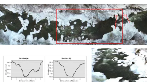
Figure 3 shows a number of broken anchor ice dams at the Sokna site. Dam locations and computed elevations and sizes can be used to derive how the ice cover will develop in the reach. This forms the foundation for understanding the hydraulic impacts of ice in steep rivers, and results can be combined with measured hydraulic variables for further eval-uation. As an example, Fig. 3 shows two vertical profiles of a broken anchor ice dam where the elevations of dam crests over the water surface is measured to 0.8 and 1 m respec-tively, indicating the elevated water level in the reach when the dams were complete.
4 Discussion and conclusion
An example of using a simple drone combined with SfM to map river ice is shown for two important types of ice, an ice jam and anchor ice dams. Using a relatively small number of GPS measured ground points, the point cloud was geo-referenced and a surface model and an orthophoto mosaic were developed. Based on the georeferenced models, data on ice thickness, volume, and spatial distribution were ex-tracted. Compared to previous measurements using GPS or total stations for mapping detailed spatial ice formations (e.g. Timalsina, 2014), the approach presented here removes the need to access the ice, which in the Sokna case would have been difficult or impossible due to the ice conditions. Even if access to the ice was possible, our new approach provides an amount and quality of data that cannot be matched by difficult and time-consuming collection of manual measure-ments.
Figure 2.Cross sections through the Gaula ice jam at three different locations marked A–A0, B–B0and C–C0. The height of the shear wall of the ice jam is marked with an arrow in each cross section. The dashed line indicates the ground level from the 1 m resolution Norwegian DEM.
Figure 3.Partly broken anchor ice dams in the Sokna reach. The upper picture shows an orthophoto mosaic of the reach, the lower graphs shows the two sections(a)and(b)marked on the picture and the picture shows the area in the red rectangle as seen from downstream.
dam positions and their width and height can be derived from the orthophoto mosaic and the surface model, but unlike the Gaula case, no ice-free geometry of the river was available to assess the volume of ice. A possible approach is to derive the elevation of the level of the open water from the SfM
632 K. Alfredsen et al.: Brief Communication: Mapping river ice
using the visible water surface has its limitations due to the turbulent surface of the water, and because the rocks and out-croppings known to be important for anchor ice dam forma-tion may not be visible in the images captured after the ice is formed. To facilitate this approach, a flight during ice-free conditions or some other kind of measurement campaign is needed to capture the size and position of large boulders and other morphological conditions that control placement of an-chor ice dams. Together with the dam positioning methodol-ogy described herein, this approach could be used to accu-rately determine the favourable conditions for development of anchor ice dams and the size of the dams. The formation of anchor ice in Sokna and other similar small rivers is cru-cial for the formation of an ice cover and for the in-stream flow conditions (Timalsina, 2014). Therefore, understanding the mechanisms for formation and location of the ice would make analysis of winter conditions more precise and would improve the ability to predict dam positions.
Our experience suggests that the ice cover was better de-tected and represented under snow free conditions than from a comparable surface with an undisturbed snow cover. It is therefore advisable to fly the reach as soon as possi-ble after an ice event has occurred and preferably before snow cover develops. In general, the DJI Phantom 3 Profes-sional is limited in poor lighting conditions due to the small 6.17×55 mm sensor. Compared to bigger sensors, the influ-ence of lighting conditions can be drastic as shutter speed is decreased, with a commensurate increase of the aperture. Because of this, the camera system is more sensitive to the influence of vibrations and movement of the UAV caused by wind. Further, bright light with dark shadows can result in poor picture quality as the camera sensor can be over-loaded by bright reflections from unshaded areas, whereas shaded areas may lack suitable information for SfM applica-tions. Therefore, we recommend manual camera settings on the Phantom 3 Professional to ensure sufficient image qual-ity for post processing. Automatic waypoint navigation (e.g. in this case with the DJI GS Pro application) can help to cre-ate a dataset with good coverage of the site and sufficient image overlapping. However, all autonomous navigation and auto camera settings increase the risk of poor picture quality, especially under less than optimal lighting conditions. Re-gardless of the approach used, data quality must be checked in the field to prevent data gaps caused by poor image acqui-sition. New versions of drones are appearing regularly, and improved sensor technology and light handling will improve picture quality, feature matching between cameras, and depth maps. This will increase the accuracy of the SfM generated surface model and orthophoto mosaics.
Labelled regions were manually extracted for correspond-ing physical features (e.g. “cracks”, “anchor ice”) followcorrespond-ing generation of the orthophoto mosaic. However, processing algorithms for advanced pixel and object-based image clas-sification have been used by the remote sensing community for decades, and geoscience practitioners have already
be-gun to develop new methods specifically tailored to 3-D point clouds derived from SfM models (Stickler et al., 2010). Once workflows for the identification and classification of phys-ical features specific to ice processes and types have been established, such as presented herein, it can reasonably be expected that machine learning may be applied to more effi-ciently classify large quantities of orthophoto imagery.
Compared to other methods, using a drone and SfM for river ice assessment is an efficient method particularly suit-able for small and medium sized rivers. Using satellites is dif-ficult in smaller watersheds due to the small size of the rivers compared to satellite pixels, and the data can be costly. Us-ing SfM with other aerial platforms like planes or helicopters is more expensive to operate, and are also not as versatile as a drone in narrow valleys and at sites with heavy bankside vegetation. Manual measurements take far more time if sim-ilar detail is needed (and may not be possible in practice), and can be difficult due to necessary safety restrictions re-lated to work on ice covered rivers. Though no photographic images are produced, the use of a terrestrial laser scanner is a possible bankside remote sensing alternative (Brostow et al., 2008) For larger or longer reaches, the number of scan posi-tions occupied may lead to a more extensive field campaign, and further processing and integration of point clouds from many positions may also consume time and effort.
There are limitations to the application of the DJI Phantom 3 Professional used here. From experience, we expect prac-tical flight range of about 1000–1300 m in open terrain when flying in non-autonomous mode. This limits the application in large rivers, and makes it necessary to fly from several lo-cations to cover longer reaches. The application of the small drone is also influenced by wind, and calm days are recom-mended both due to operation and for the best possible image quality. Another issue relates to battery life in cold weather. The flight time is around 20 min, and it is necessary to pay at-tention to the battery status to avoid sudden loss of voltage in cold batteries. For sustained operation in cold climates sev-eral batteries are recommended, and spare batteries should be kept as warm as possible. A final issue to consider is oper-ational constraints set by applicable aviation regulations that must be consulted before each flight, which may limit system size, mass, range, elevation, timing, etc.
the jam. These data are critical for understanding the river ice breakup processes and may aid in assessing potential dam-ages that can result.
Data availability. The images used in the analysis can be downloaded from: Sokna: http://folk.ntnu.no/knutal/TC/Sokna.zip; Grana: http://folk.ntnu.no/knutal/TC/RAW.zip. The file-size is about 5 GB each.
Author contributions. All authors contributed to the design of the field work based on previous measurements by KA. All authors par-ticipated in the field work, and CH flew the drone and acquired the images. KA did the analysis supported by JAT and CH, and PZ pro-vided the ice-free geometry data. KA wrote the manuscript with input from all co-authors.
Competing interests. The authors declare that they have no conflict of interest.
Acknowledgements. JAT and CH participated in the field work as part of the workshop on data processing from images gained by unmanned aircraft systems that was funded by the European Eco-nomic Area (EEA) Grant “Restoration of the aquatic and terrestrial ecosystems at Fundu Mare Island” (Project Number RO02-0008) with financial contributions from Norway and Romania. The authors wish to thank the three reviewers who provided very useful input to the manuscript.
Edited by: Peter Morse
Reviewed by: Karl-Erich Lindenschmidt, Shawn Clark, and Mark Loewen
References
Ansari, S., Rennie, C., Seidou, O., Malenchak, J., and Zare, S.: Automated monitoring of river ice processes using shore-based imagery, Cold Reg. Sci. Technol., 142, 1–16, https://doi.org/10.1016/j.coldregions.2017.06.011, 2017. Arif, M., Gülch, E., Tuhtan, J., Thumser, P., and Haas, C.:
An investigation of image processing techniques for sub-strate classification based on dominant grain size using RGB images from UAV, Int. J. Remote Sens., 38, 2639–2661, https://doi.org/10.1080/01431161.2016.1249309, 2016. Beltaos, S.: River ice jams, Water Resources Publishers LLC,
High-lands Ranch, Colorado, 372 pp., 1995.
Beltaos, S. and Kääb, A.: Estimating river discharge during ice breakup from near-simultaneous satellite imagery, Cold Reg. Sci. Technol., 98, 35–46, 2014.
Brooks, R. N., Prowse, T., and O’Connel, I. J.: Quantifying North-ern Hemisphere freshwater ice, Geophys. Res. Lett., 40, 1128– 1131, https://doi.org/10.1002/grl.50238, 2013.
Brostow, G., Shotton, J., Fauqueur, J., and Cipolla, R.: Segmenta-tion and recogniSegmenta-tion using structure from moSegmenta-tion point clouds,
European Conference on Computer Vision, Springer, Berlin, Heidelberg, 44–57, 2008.
Chu, T. and Lindenschmidt, K.-E.: Integration of space-borne and air-borne data in monitoring river ice processes in the Slave River, Canada, Remote Sens. Environ., 181, 65–81, https://doi.org/10.1016/j.rse.2016.03.041, 2016.
Mermoz, S., Allain-Bailhache, Bernier, M., Pottier, E., Van Der Sanden, J., and Chokmani, K.: Retrieval of River Ice Thickness From C-Band PolSAR Data, IEEE T. Geosci. Remote, 52, 3052– 3062, https://doi.org/10.1109/TGRS.2013.2269014, 2014. Nolan, M., Larsen, C., and Sturm, M.: Mapping snow depth from
manned aircraft on landscape scales at centimeter resolution us-ing structure-from-motion photogrammetry, The Cryosphere, 9, 1445–1463, https://doi.org/10.5194/tc-9-1445-2015, 2015. Prowse, T. and Culp, J.: Ice breakup: a neglected factor in river
ecol-ogy, Can. J. Civil Eng., 30, 128–144, 2003.
Ryan, J. C., Hubbard, A. L., Box, J. E., Todd, J., Christoffersen, P., Carr, J. R., Holt, T. O., and Snooke, N.: UAV photogram-metry and structure from motion to assess calving dynamics at Store Glacier, a large outlet draining the Greenland ice sheet, The Cryosphere, 9, 1–11, https://doi.org/10.5194/tc-9-1-2015, 2015. Smith, M. and Vericat, D.: From experimental plots to
experi-mental landscapes: topography, erosion and deposition in sub-humid badlands from Structure-from-Motion photogrammetry, Earth Surf. Proc. Land., 40, 1656–1671, 10.1002/esp.3747, 2015. Smith, M., Carrivick, J., and Quincey, D.: Structure from motion photogrammetry in physical geography, Prog. Phys. Geogr., 40, 247–275, https://doi.org/10.1177/0309133315615805, 2016. Stickler, M., Alfredsen, K., Linnansaari, T., and Fjeldstad, H.-P.:
The influence of dynamic ice formation on hydraulic heterogene-ity in steep streams, River Res. Appl., 26, 1187–1197, 2010. Timalsina, N. P.: Ice conditions in Norwegian rivers regulated for
hydropower: An assessment in the current and future climate, PhD thesis, Department of Hydraulic and Environmental En-gineering, Norwegian University of Science and Technology, Trondheim, 2014.
Turcotte, B. and Morse, B.: Ice processes in a steep river basin, Cold Reg. Sci. Technol., 67, 146–156, 2011.
Turner, D., Lucier, A., and Watson, C.: An Automated Technique for Generating Georectified Mosaics from Ultra-High Resolution Unmanned Aerial Vehicle (UAV) Imagery, Based on Structure from Motion (SfM) Point Clouds, Remote Sens., 4, 1392–1410, https://doi.org/10.3390/rs4051392, 2012.
Vasquez-Tarrio, D., Borgniet, L., Liebault, F., and Recking, A.: Us-ing UAS optical imagery and SfM photogrammetry to charac-terize the surface grain size of gravel bars in a braided river (Veìneìon River, French Alps), Geomorphology, 285, 94–105, https://doi.org/10.1016/j.geomorph.2017.01.039, 2017. Westoby, M., Brasington, J., Glasser, N., Hambrey, M., and
Reynolds, J.: “Structure-from-Motion” photogrammetry: A low-cost, effective tool for geoscience applications, Geomorphology, 179, 300–314, https://doi.org/10.1016/j.geomorph.2012.08.021, 2012.