CPWF Project Report
Basin Focal Project Volta
Project Number 55
Jacques Lemoalle
Institut de Recherche pour le Développement (IRD),
Montpellier, France
Contents
CPWF Project Report
Page | ii
Acknowledgements
The BFP Volta team has benefited from many positive interactions with a number of persons and teams, who all have contributed in one way or another to the completion of this project. We wish to thank them all:
- The CPWF secretariat, coordinated by Jonathan Woolley and Alain Vidal , with Sharon Perera, Pamela George, Marene Abeyesekere, Lalith Dassenaike, who have all been very helpful and made administration of the project almost enjoyable.
- The BFP central, Simon Cook, Maya Rajasekharan and Tassilo Tiemann, who have developed lots of energy and provided useful ideas, comments and much more to support our work, and Myles Fisher who transformed our BFP special session in the World Water Congress in Montpellier into a journal issue.
- Other BFP team leaders and scientific projects in the Volta basin in particular GLOWA Volta with Nick van de Giesen and Jens Liebe, and PAGEV with Kwame Odame-Ababio. - The national institutions and services in the ministries of agriculture in Ghana (MOFA)
and Burkina Faso (MAHRH); INSS, IRSS and especially DGRE with Francis Bougaïré in Ouagadougou; WRI in Accra with the Volta basin coordinator Winston Andah, SARI in Tamale and fisheries services in Yeji.
- International institutions with Akiça Bahri, Pay Drechsel, Boubacar Barry in IWMI Accra, Rui Luis Silva and Florence Ardorino in ECOWAS-WRCC, Charles Biney and the VBA national focal points.
- Too many other individuals have directly contributed to the project, it is not possible to list them here but they have their share in the completion of the BFP Volta
Our IRD colleagues, in France, Burkina Faso or Mali have provided help to many aspects of the project. IRD has contributed in kind to its total cost.
The following research partners contributed to the BFP Volta studies: Core team
Winston ANDAH, basin coordinator, WRI, Accra, Ghana Philippe CECCHI, IRD Ouagadougou, Burkina Faso Devaraj de CONDAPPA, IRD Montpellier, France Jacques LEMOALLE, IRD, Montpellier, France Isabelle TERRASSON IRD (now BRL, Nîmes) France
Contributors
Meike ANDERSSON, CIAT, Cali, Colombia Felix Ankomah ASANTE, ISSER, Accra, Ghana Christophe BENE, Worldfish, Cairo, Egypt
Jean-François BOYER, HSM-IRD, Montpellier, France Anne CHAPONNIERE, IWMI, Accra, Ghana
Jean-Charles CLANET, IRD, Montpellier, France
Evariste Constant DA DAPOLA, Univ. Ouagadougou, Burkina Faso Claudine DIEULIN, HSM-IRD, Montpellier, France
Jean-Marie DIPAMA, INSD, Ouagadougou, Burkina Faso Myles FISHER, CIAT, Cali, Colombia
Contents
CPWF Project Report
Larry HARRINGTON, Cornell University and CPWF
Valérie HAUCHART, Univ. Reims (now Univ. Limoges) France Edmond HIEN, IRD/Univ. Ouagadougou, Burkina Faso Erik KEMP-BENEDICT, SEI, USA
Camille MARQUETTE, G-Eau (IRD), Montpellier, France Aude MEUNIER-NIKIEMA, INSD, Ouagadougou, Burkina Faso Marie MOJAISKY, Verseau Développement, Montpellier, France Madiodio NIASSE, IRD, Montpellier, France
Jean-Noël PODA, INSS, Ouagadougou, Burkina Faso
Jorge RUBIANO, National University of Colombia, Palmira, Colombia Aaron RUSSEL, Worldfish, Cairo, Egypt
Tom SOO, Verseau Développement, Montpellier, France with collaboration of Masters interns:
Victor BRUNEL, Joël CACHERA, Abir BEN SLIMANE, Fabien LANGLOIS, Julien HENIQUE, Orianne LABBE.
The help of the BFP Central and of CPWF Head Office is gratefully acknowledged. We are also very much indebted for the help we have received from numerous people, administrations and institutions in the basin countries.
The work was developed within our laboratory, Unité Mixte de Recherche Gestion de l’Eau, Acteurs et Usages (G-Eau), which belongs to IRD, CIRAD, CEMAGREF and SupAgro in Montpellier, France.
Contents
CPWF Project Report
Page | iv
Program Preface
The Challenge Program on Water and Food (CPWF) contributes to efforts of the international community to ensure global diversions of water to agriculture are maintained at the level of the year 2000. It is a multi-institutional research initiative that aims to increase the resilience of social and ecological systems through better water management for food production. Through its broad partnerships, it conducts research that leads to impact on the poor and to policy change.
The CPWF conducts action-oriented research in nine river basins in Africa, Asia and Latin America, focusing on crop water productivity, fisheries and aquatic ecosystems, community arrangements for sharing water, integrated river basin management, and institutions and policies for successful implementation of developments in the water-food-environment nexus.
Project Preface
Challenge Program Water and Food: Basin Focal Project Volta
The Basin Focal Project Volta (BFP Volta) was developed along three main steps: Assessment of present conditions of the distribution of rural poverty, of farming
systems with their productivity and water productivity;
Analysis of opportunities and risks, especially under the double pressure of demography and possible climate change, and modeling of water resources to identify sensitivity of water allocation to development and climate scenarios; and
Identification of research gaps and implementation plan.
The study indicated that while many technical solutions are available and identified, their socio-economic acceptability and implementation still need further research and efforts.
CPWF Project Report series
Each report in the CPWF Project Report series is reviewed by an independent research
supervisor and the CPWF Secretariat, under the oversight of the Associate Director. The views expressed in these reports are those of the author(s) and do not necessarily reflect the official views of the CGIAR Challenge Program on Water and Food. Reports may be copied freely and cited with due acknowledgment. Before taking any action based on the information in this publication, readers are advised to seek expert professional, scientific and technical advice.
This report is to be cited as:
Lemoalle, J. 2008. Basin Focal Project Volta. CPWF Project Report series, Challenge Program on Water and Food, Colombo, Sri Lanka, 81p.
Contents
CPWF Project Report
TABLE OF CONTENTS
PROJECT HIGHLIGHTS...11
1. Basin Focal Project Volta ...11
2. Water availability ...11
3. Water productivity...11
4. Policy recommendations...12
EXECUTIVE SUMMARY ...13
1. Basin Focal Projects ...13
2. Background ...13
2.1. Ecological zones and water availability... 13
2.2. Agriculture ... 13
2.3. Water-Agriculture-Poverty links ... 14
3. Opportunities ...14
SYNTHESIS REPORT ...16
1 INTRODUCTION AND OVERVIEW ...16
1.1 The CPWF ... 16
1.2 Basin Focal Projects... 16
1.3 Overview and outline... 16
2. THE VOLTA BASIN INTRODUCED ...19
3. WATER AVAILABILITY ...23
3.1. Rainfall, surface water and groundwater ... 23
3.2. Water use ... 25
4. FARMING SYSTEMS AND FOOD PRODUCTION ...29
4.1. Rainfed farming systems... 31
4.2. Other cropping systems ... 34
4.3. Livestock systems ... 35
4.4. Fisheries systems... 36
4.5. Production and yields ... 37
4.6. Livestock ... 40
4.7. Fisheries ... 40
5. WATER PRODUCTIVITY...43
5.1. Basin scale ... 43
5.2. Field scale ... 43
6. WATER AND POVERTY ...47
6.1. Poverty and land... 48
6.2. Water quality and access ... 50
6.3. Water related diseases ... 50
6.4. Exploring cause and effect ... 53
6.5. Poverty mapping and Bayesian networks ... 53
7. INSTITUTIONS ...57
7.1. The basin context: the Volta Basin Authority ... 57
7.2. Basin scale water management tools ... 58
7.3. The national context of dual governance systems... 58
7.4. Land tenure and access to water... 59
7.5. Access to markets for food crops ... 60
Contents
CPWF Project Report
Page | vi
9.2. The development of small reservoirs ... 66
9.3. The use of fertilizers ... 66
10. KNOWLEDGE MANAGEMENT...69
11. INTERNATIONAL PUBLIC GOODS...71
12. CONCLUSIONS ...73
PUBLICATIONS...75
BFP Volta Reports series (all on PBWiki webpage)... 75
Journal articles and book chapters ... 76
Other publications ... 76
Congress presentations ... 76
Database... 77
Contents
CPWF Project Report
LIST OF TABLES
Table 1. Land use in the countries of the Volta basin... 20
Table 2. The main hydropower schemes in the Volta basin... 28
Table 3. Information on poverty in Volta basin countries ... 49
Table 4. Global trends in the Volta basin and their consequences on the rural activities... 61
Table 5. Trends of demographic evolution in the Volta basin extrapolated from present population growth rates ... 61
Research Highlights
CPWF Project Report
Page | viii
LIST OF FIGURES
Figure 1: CPWF benchmark basins ... 16
Figure 2. Flow diagram of the BFP analysis ... 17
Figure 3. The Volta basin and its political boundaries ... 19
Figure 4. The relationship between the relative importance of agriculture and the incidence of rural poverty in some emergent and developing countries ... 20
Figure 5. Spatial distribution of area cropped for food production in Burkina Faso and Ghana 21 Figure 6. The agro ecological zones with a summary of the water account in the Volta basin, and the distribution of rainfall in four stations along the south-north gradient ... 24
Figure 7. Normalized rainfall anomaly index for the West African Sahel (1896-2000) with a mean value computed for 1921-2000... 25
Figure 8. Water accounting in the different sub-basins of the Volta River ... 27
Figure 9. The main cropping systems in the Volta basin... 30
Figure 10. The North-South gradient in agro ecological zones and agricultural systems ... 31
Figure 11. The similar time trends of cultivated area, total production and increase in population ... 31
Figure 12. Mean yields of the main food crops in the basin ... 33
Figure 13. Grain yields at 50 and 20 percent probabilities for simulated crops of maize on a 9-degree transect on the meridian of Ouagadougou (1.53ºW) in the Volta Basin ... 34
Figure 14. The distribution of cattle density in West Africa ... 36
Figure 15. Relationship between maize yields and annual rainfall... 38
Figure 16. Relationship between millet yields and annual rainfall ... 38
Figure 17. Spatial distribution of crop yields... 39
Figure 18. Effect of fertilizer on crop yields in Northern Ghana ... 40
Figure 19. The mean water productivity (1992 to 2000) of the main food crops in the Volta basin ... 44
Figure 20. Relationship between sorghum water productivity and annual rainfall ... 45
Figure 21. Spatial incidence of poverty in Ghana, Burkina Faso and northern Togo ... 48
Figure 22. Lorenz curves of farm area for three locations in the Volta basin ... 49
Figure 23. Proportion of farmers in three regions using inorganic fertilizer, by farm size ... 49
Figure 24. Total farm food sales for three regions, by farm size... 50
Figure 25. Percent of the population in the department (Burkina Faso) or province (Ghana) who rely on surface water or traditional wells... 51
Figure 26. Malaria prevalence in the Volta basin ... 52
Contents
CPWF Project Report
LIST OF ACRONYMS
BFP Basin Focal Projects
CPWF Challenge Program on Water and Food
CRU Climate Research Unit, University of East Anglia DSSAT Decision Support System for Agrotechnology Transfer
EBCVM Enquête sur le Conditions de Vie des ménages, Burkina Faso, 2003 ECOWAS /
CEDEAO
Economic Community of West African States / Communauté Economique des Etats de l’Afrique de l’Ouest
FAO Food and Agriculture Organization of the United Nations
GLOWA Global Change and the Hydrological Cycle, Bonn University, Germany GLSS 1998 Ghana Living Standard Survey in 1998-99
IWRM Integrated Water Resources Management
MAHRH Ministère de l’Agriculture, de l’Hydraulique et des Ressources Halieutiques, Burkina Faso
MDG Millennium Development Goals
MOFA Ministry Of Fisheries and Agriculture, Ghana NEPAD New Partnership for Africa’s Development
PAGEV Project for Improving Water Governance in the Volta River Basin, implemented by the International Union for Conservation of Nature VBA / ABV Volta basin Authority / Autorité du Bassin de la Volta
WEAP Water Evaluation and Planning System, a model by Stockholm Environment Institute
WRCC / CCRE Water Resources Coordination Centre / Centre de Concertation sur les Ressources en Eau
SIEREM Système d’Informations Environnementales sur les Ressources en Eau et leur Modélisation
MARA/ARMA Mapping Malaria Risk in Africa/Atlas du Risque de la Malaria en Afrique
Research Highlights
CPWF Project Report
PROJECT HIGHLIGHTS
1.Basin Focal Project Volta
The Basin Focal Project Volta analyzes poverty, water availability and agricultural water use to help understand how agriculture and water in the Volta basin support livelihoods. The project team was led by IRD (France).
The Volta basin lies predominantly in Ghana and Burkina Faso, with small areas in Benin, Côte-d’Ivoire, Mali and Togo. These countries rank amongst the poorest in the world. The Basin is inhabited by 19 million people, of whom 70% are rural. Poverty remains strongly rural and increases from south to north. Economies are reliant on rain fed agriculture. Rural poverty occurs because of low agricultural productivity, limited market access and price variability. Population density is generally low but is expected to increase as population increases to a projected 50-60 million by 2050. The ratio of rural:urban population will decrease dramatically from 2.3 now to 0.5 in 2050. The main forces of change are a combination of demography with increasing urbanization, and the impacts of climate change.
2.Water availability
Rainfall in the Basin varies between 500-1100 mm/year. The Basin crosses four agro-ecological zones going from the wetter Guinean zone to the arid Sahel, with high rainfall variability both between years and within the rainy season of any one year.
Less than 10% of the total rainfall ends up in the river. Run-off increases from north to south, accounting for less than 5% of rainfall in the upper basin, increasing to 15% in the lower reaches. River discharge is highly sensitive to variations in annual rainfall. A large number of small-size reservoirs have been developed for small-scale irrigation, especially in the northern part of the Basin. Ground water resources are poorly quantified and seem to be under exploited. At the basin scale, a very small fraction of the renewable water is stored in reservoirs for uses other than hydropower, while in most developed countries this fraction amounts to 70-90 % (World Water Assessment Programme, 2009).
Lake Volta plays a key role in the economy of Ghana but flows and revenues from hydro-electricity from the Akosombo-Kpong schemes are less than were anticipated. Low inflows to the dam seem to be a consequence of long-term reduction in annual rainfall. The much smaller Bagré and Kompienga reservoirs are important in Burkina Faso for hydropower and for irrigation.
Lack of access to potable water, and diarrhea from unsafe domestic water, are recognized causes of poverty, with important consequences for health and manpower, and with a strong economic impact at both the family and the basin scales. In the Basin, the proportion of households using poor-quality water is close to 50% both in Ghana and Burkina Faso.
The other main water-related diseases in the Basin are malaria, schistosomiasis (bilharzia), onchocercosis (river blindness), and trypanosomiasis. Malaria occurs throughout the basin, with a 100% prevalence in the central part of the Basin. The cost of malaria in Ghana hits poor households hardest.
The new Volta Basin Authority is a main stakeholder for basin-wide and transnational matters. At the national scale, the legal state and traditional hierarchy coexist in a dual system, that leads to institutional difficulties.
Research Highlights
CPWF Project Report
Page | 12
Yields and water productivity are low, often 10% or less of potential. Rain-fed cropping occupies only about 14% of the Basin area. Most of the production increase of the last decade has come more from an increase in the cropped area than from increased productivity. The low yields result from risk avoidance strategies adopted by the farmers to cope with uncertainties about water availability (variability of rainfall in time and space), poor and degraded soils, with no or low input of fertilizers, and poor productive assets ( draft animals, man power limited by frequent diseases).
The low productivity coupled with limited market access, unstable prices, and insecure land tenure in some regions worsen the effects. At the basin scale, because only a small percentage of the basin’s area is cropped, overall crop water productivity is even lower.
4.Policy recommendations
Improvements in the rain-fed systems, coupled with investment in fertilizers and small-scale irrigation, offer the main opportunity for development. Other positive measures include improvements in infrastructure, secure and transparent land tenure, access to agricultural water and affordable micro-credit. The technical possibilities for improvement have been well identified, but the social and economic conditions for their implementation are still lacking. Small reservoirs require careful monitoring to prevent them reducing flows into hydro-electric projects but these risks seem modest compared to rainfall variability and the possible effects of climate change. Ground water resources should be assessed as a possible tool for extensive development of small-scale irrigation.
Contributions from fisheries and livestock seem to be underestimated and need careful socio-economic appraisal.
The Basin states have a limited ability to implement and enforce policies and reforms at the local level. Social control is highly fragmented, and policy implementation, if sincerely attempted at all, takes place in the context of multiple foci of power and multiple institutions. In the Volta basin, the duality between the legal state and the traditional hierarchy impacts every day life and a number of social determinants such as land tenure and access to water. Institutional development is therefore key to assist development, which in turn depends on strong political will.
Executive Summary
CPWF Project Report
EXECUTIVE SUMMARY
1.Basin Focal Projects
CPWF Basin Focal Projects (BFPs) are designed to perform two functions: (1) provide whole-basin assessments of water availability, poverty, food security, and water productivity, and (2) examine water-related institutional and technical interventions, to ascertain the extent to which they might contribute to poverty reduction, resilient livelihoods, and environmental conservation. A first round of BFPs was implemented in the basins of the Karkheh, Mekong, São Francisco and Volta Rivers. This paper summarizes some emerging results from the Volta BFP. In the Volta BFP, hydrological and water allocation models were used to analyze basin-wide options for water management in different climate change scenarios. National economies rely heavily on agriculture, which contributes 30-40% of GDP. Crop modeling was used to identify factors limiting water productivity as the farming systems change in response to decreasing and more unreliable rainfall as one moves from south to north across the Basin.
2.Background
The Volta basin, which covers 395,000 km2, is shared by six West African countries, with Ghana and Burkina Faso occupying 83% of the area. At present, 19 million people inhabit the Basin, but by 2050 this will increase to 50-60 million people. In 2005, there were 2.3 rural inhabitants for each urban resident. By 2050 this ratio is expected fall to 0.5. Currently, population density is rather low at about 48 persons per km2. The main driving forces for change are demography, urbanization, migration, and climate change.
2.1.Ecological zones and water availability
The Basin contains four agro ecological zones: the Sahel (annual precipitation less than 500 mm), located in the northernmost part of the basin, dominated by livestock grazing and some millet production; the Sahelo-Sudan (500-900 mm), covering most of Burkina Faso and the small part of the Basin in Mali; the Sudan (900-1,100mm of rainfall per year), covering the northern half of Ghana and the parts of the Basin in Côte-d’Ivoire, Benin and Togo, dominated by sorghum, millet, maize, cotton and groundnut production; and the Guinean zone (above 1,100mm with a bi-modal distribution), covering southern Ghana, and dominated by root and tree crops. Apart from the Guinean zone, rainfall distribution is unimodal with the short growing season (June to November) becoming even shorter in the north.
Average runoff in the upper basin is about 5% of rainfall, increasing to over 15% in the lower reaches. River discharge is sensitive to variations in annual rainfall, with a ±10% change in annual rainfall leading to about ±40% change of river discharge. Most rivers in Burkina Faso dry up during the dry season, except where hydropower reservoirs maintain continuous flow. With higher rainfall, Ghana aims to maximize energy production from the Volta Lake with its Akosombo-Kpong hydropower scheme. Groundwater resources are poorly quantified and under exploited.
The rainfall regime in West Africa has varied over the years, changing from a relatively wet period (1950-69) to a drier period (1970-90), which effectively moved the isohyets 150 km to the south. Changes in rainfall patterns associated with climate change have not yet been modeled definitively at the basin scale. Most models indicate either a slight positive or a slight negative change of rainfall for 2050, with an increased probability of extreme events. We used a plus or minus one degree latitudinal shift of the isohyets as an hypothesis in the climate change scenarios we examined for the Volta Basin.
Executive Summary
CPWF Project Report
Page | 14
small. The median rain fed area cultivated by a family in Burkina Faso is 3.1 ha. The smallest farms are less than 1.4 ha.
A large number of small reservoirs have been developed in the upper basin for small-scale irrigation, which has helped some farmers to improve their incomes. Where large-scale irrigation exists, it typically competes for labor with traditional rain-fed farming. Overall, however, only 0.5% of the cultivated area is irrigated.
In most of the Basin, total annual rainfall is sufficient to obtain high crop yields. Nonetheless, yields are typically low. Average maize yield in Ghana is 1.5 t/ha, in Burkina Faso 1.2 t/ha. Water productivity of maize is less than 0.2 kg/m3. This is attributed to rainfall spatial and temporal variability, poor soils, low input use, poor market infrastructure and low labor productivity. Typically farmers use low planting densities, which is a risk-avoidance strategy where rainfall is unreliable, but also entails that yields will always be low. In addition to low inherent fertility, soils in the Basin suffer from negative nutrient balances: more nutrients are taken off than are applied. Increase food production has come from increasing the area under cultivation rather than increasing yields.
2.3.Water-Agriculture-Poverty links
According to national poverty standards, about 50% of people in Ghana (1998) and Burkina Faso (2003) are poor. The World Bank, however, places poverty rates much higher: 63% for Ghana and 85% for Burkina Faso. Poverty is strongly rural and increases from south to north. Rural poverty is caused by low agricultural productivity, limited market access, price variability and insecure land tenure. Cash-crop farmers are less poor than subsistence farmers. The poorest farmers, fishermen or livestock farmers have similar poverty attributes : vulnerability resulting of a total dependence on the yield or catch, insufficient assets and low productive capacity..
Lack of access to clean water is another cause of poverty, through its impact on health and hence on farm labor. Access to domestic water was analyzed with respect to distance or time to fetch water, and the quality of the water. About 50% of households in the Basin use poor quality water, i.e. open wells and surface water. Principal water-related diseases in the Basin include malaria, schistosomiasis (bilharzia), onchocercosis (river blindness), trypanosomiasis and diarrhea. Malaria covers the whole basin, with a 100% prevalence in a large area of the central part of the Basin. The cost of malaria treatment is about USD$7 per treatment – out of the reach of most poor households.
Improvements in rain-fed agriculture appear to provide important opportunities for improving livelihoods. Soil and water conservation practices, at present used only on the most degraded soils, have the potential to improve yields and decrease vulnerability. Fertilizer use has been shown to increase potential yields, though such gains become increasingly risky north of Ouagadougou because of rain variability.
Investments to alleviate poverty are constrained by the high cost of developing infrastructure as well as by other institutional limitations such as land tenure insecurity for farmers and insecure access to water for herders. Apart from poor infrastructure, subsidized agriculture in developed countries hampers Basin farmers’ access to national and international markets. This is particularly the case for cotton.
Basin states have a limited ability to implement and enforce policies at the local level. Social control is highly fragmented, and policy implementation must take place through a complex of multiple institutions. The duality between the legal state and the traditional hierarchy impacts every aspect of life and a number of social determinants such as land tenure and access to water. The new Volta Basin Authority is the main stakeholder for basin-wide and transnational matters.
3.Opportunities
It is forecasted that the rural population will increase slightly during the next 40 years. Opportunities to reduce rural poverty and improve livelihoods through water-related interventions and research are:
Executive Summary
CPWF Project Report
Irrigation development: The World Bank Africa Region irrigation business plan (2008-2012) for poverty reduction ranks Ghana, Burkina Faso, and Mali in Group 1 countries, where investment in irrigation and rain-fed cultivation is recommended.
Groundwater development: The groundwater resource should be assessed as a possible tool for extensive development of small-scale irrigation. The geological setting has some similarity with central India where the Green Revolution occurred.
Fertilizer use and micro-credit: An important opportunity is to develop incentives for smallholder farmers in rain-fed systems to invest in fertilizers and small-scale irrigation. Research is needed to reduce barriers to fertilizer use, and increase its socio-economic acceptability.
Livestock and fisheries: Livestock and fish systems support many of the poor. Fisheries need to be monitored to allow sound management to be implemented. Services provided by the aquatic ecosystems are not well understood and need socio-economic appraisal. A better use of forage browse for livestock would improve water productivity and animal production. Increasing conflict between nomadic herders and sentient farmers for access to drinking water for the nomads’ livestock requires resolution at the institutional level.
Institutional and market development: Institutional development is key to resolve the ubiquitous traditional/legal duality. The national or regional food market has to be organized in the same way as the cash crop market. Pro-poor activities will involve combined improvements in the access to land, to agricultural water, and to affordable micro credit for this part of the population.
Small reservoir management: Small reservoirs require careful management to prevent exclusion of the poorest and careful monitoring to reduce the threat to flows on which Akosombo, Bagré, and other large hydro-electric schemes depend.
Water governance: Strong political will is needed to implement successful water reforms that mirror the principles and objectives of IWRM. These reforms will create mechanisms to involve local water users and to mediate conflicting interests effectively under the current institutional, administrative, and political conditions. The simulation tool developed by BFP Volta in collaboration with IUCN-PAGEV for analysis of transboundary water-sharing may foster dialogue on IWRM.
Introduction
CPWF Project Report
Page | 16
SYNTHESIS REPORT
1
INTRODUCTION AND OVERVIEW
1.1 The CPWF
The CGIAR Challenge Program on Water and Food (CPWF) brings together scientists, development specialists, and river basin communities in Africa, Asia and Latin America to address challenges of water scarcity and food security. It is an institutional innovation that deals in an integrated fashion with multi-scale water problems and their effects on agriculture. It helps build a water dimension into on-going research on food, poverty, the environment, and livelihoods. It breaks down boundaries between institutional structures and mobilizes the efforts of a diverse group of stakeholders. In these ways, it contributes to the institutional reform of the CGIAR system.
CPWF activities include competitive grant projects, commissioned synthesis research, and Basin Focal Projects (BFPs).
1.2 Basin Focal Projects
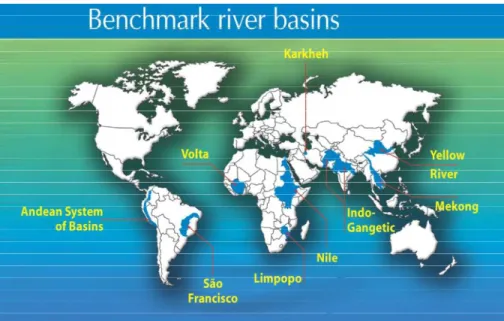
The purpose of BFPs is to identify and evaluate, across scales, strategies for addressing water, food and poverty problems in specific basins. In 2005, BFPs were launched in four benchmark basins: Karkheh, Mekong, São Francisco, and Volta. In 2008, additional BFPs started in another six basins (Figure 1). This report focuses on the Volta.
Figure 1. CPWF benchmark basins. Source: CPWF.
Basin Focal Projects were designed to answer three specific questions: 1. How are water, food and poverty related?
2. What are the principal links between a globally-defined water crisis, and conditions on the ground in specific basins?
3. How can the study of river basin function help identify actions for addressing water, food and livelihood issues, and illuminate the consequences of taking these actions?
1.3 Overview and outline
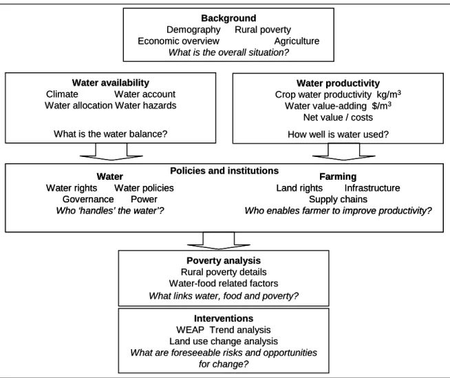
This report is organized according to the general schema shown in Figure 2. To facilitate comparison between basins, this logic is replicated in other basins as far as allowed by the context, depth of analysis and availability of data.
Introduction
CPWF Project Report
Figure 2. Flow diagram of the BFP analysis.
First, the Volta Basin is introduced using broad background statistics that help put the Basin in a regional or global context. Then the report provides information on water availability in the Basin, including rainfall quantity and distribution, water use or water accounting, and equity of access to water for different users. Drought appears important in parts of the Volta, and this hazard demands particular attention.
In parallel, water productivity estimates are described in relation to farming practices, and the combined insight of water and agricultural factors is used to help explain the condition of rural poverty in the Basin. Policies and institutions in the Basin, both formal and informal, are important conditioning factors that influence the link between water, agriculture and poverty, and therefore institutional drivers of water allocation and features described such as land tenure, access and markets. Finally, opportunities for using water-related interventions to address water and food problems in the Volta are identified, and the consequences for different water users of major changes are analyzed.
Background
Demography Rural poverty Economic overview Agriculture
What is the overall situation?
Water availability
Climate Water account Water allocation Water hazards
What is the water balance?
Water productivity
Crop water productivity kg/m3 Water value-adding $/m3
Net value / costs How well is water used?
Interventions
WEAP Trend analysis Land use change analysis
What are foreseeable risks and opportunities for change?
Poverty analysis
Rural poverty details Water-food related factors What links water, food and poverty?
Water
Water rights Water policies Governance Power Who ‘handles’ the water’?
Farming
Land rights Infrastructure Supply chains
Who enables farmer to improve productivity?
Policies and institutions Background
Demography Rural poverty Economic overview Agriculture
What is the overall situation?
Water availability
Climate Water account Water allocation Water hazards
What is the water balance?
Water productivity
Crop water productivity kg/m3 Water value-adding $/m3
Net value / costs How well is water used?
Interventions
WEAP Trend analysis Land use change analysis
What are foreseeable risks and opportunities for change?
Poverty analysis
Rural poverty details Water-food related factors What links water, food and poverty?
Water
Water rights Water policies Governance Power Who ‘handles’ the water’?
Farming
Land rights Infrastructure Supply chains
Who enables farmer to improve productivity?
Water
Water rights Water policies Governance Power Who ‘handles’ the water’?
Farming
Land rights Infrastructure Supply chains
Who enables farmer to improve productivity?
Introduction
CPWF Project Report
2. THE VOLTA BASIN INTRODUCED
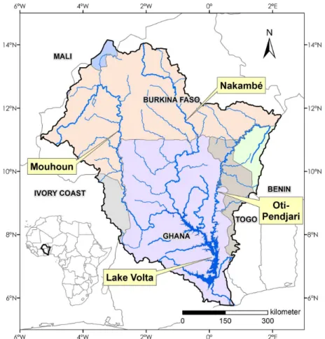
The Volta Basin, located in West Africa, covers an area of around 395,000 km2 across six countries: Benin, Burkina Faso, Côte-d’Ivoire, Ghana, Mali, and Togo (Figure 3). Among them, Burkina Faso and Ghana account for 83% of the Basin area, but the Basin also covers 47% of Togo. For a major river basin, the Volta is not particularly large: it covers about the same area as the Limpopo and is far smaller than the Ganges, Mekong or Nile basins (1.0, 1.8 and 3.2 million km2, respectively).
About 20 million people live in the basin. Most (13.5 million) are rural. While inroads have been made to reduce poverty in some areas, rural poverty remains high, especially in Burkina Faso. Population density is around 48 persons/km2, higher than in the Limpopo but far lower than densely-populated basins such as the Ganges (32 and 401 persons/km2 respectively).
Figure 3. The Volta basin and its political boundaries. Source: BFP Volta with the river systems from Dieulin, 2007.
Introduction
CPWF Project Report
Page | 20
China
Agricultural and rural pov e rty
-10 0 10 20 30 40 50 0 0.2 0.4 0.6 0.8 1 Ru ra l po ve rty (a s % of to ta l) C o n tr ib u ti o n o f a g ri c u lt u re t o G D P C hina India B razil N igeria C o te d’Ivo ire B u rk ina Faso G hana To go N iger China
Agricultural and rural pov e rty
-10 0 10 20 30 40 50 0 0.2 0.4 0.6 0.8 1 Ru ra l po ve rty (a s % of to ta l) C o n tr ib u ti o n o f a g ri c u lt u re t o G D P C hina India B razil N igeria C o te d’Ivo ire B u rk ina Faso G hana To go N iger
Figure 4. The relationship between the relative importance of agriculture and the incidence of rural poverty in some emergent and developing countries. Rural poverty and agriculture contribution to GDP decrease when urbanization and industrialization develop. The size of bubbles represents the rural populations Source: World Development Report 2008: Agriculture for Development. The World Bank.
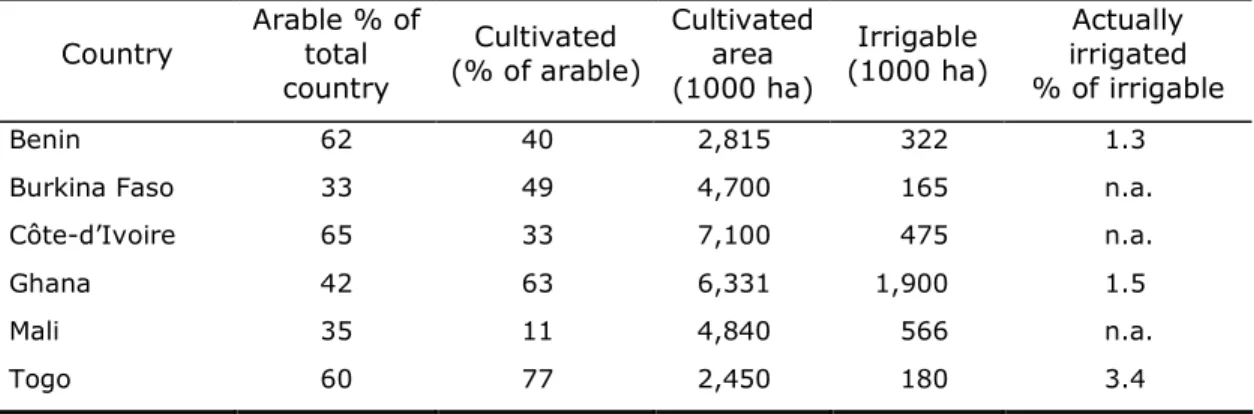
About 30-60% of the total land resources in the basin, are considered arable. A large proportion of this, however, is left uncultivated (Table 1 and Figure 5).
Expansion of cultivated area over the past 30 years is related to population growth. There has been little if any increase in cultivated area per capita (Serpantié 2003)(Figure 11). It would appear that scarcity of productive assets and water, not land, are the factors that limit production.
In comparison with so-called transitional economies (such as India or China) or industrialized economies, countries of the Volta Basin remain predominantly agricultural (World Bank, 2008). Most of the poor are rural. Commercial agriculture has influence in parts of Ghana and with cotton in southern Burkina Faso.
Table 1. Land use in the countries of the Volta basin (data for 2003-07, modified from FAO Aquastat 2005). Country Arable % of total country Cultivated (% of arable) Cultivated area (1000 ha) Irrigable (1000 ha) Actually irrigated % of irrigable Benin 62 40 2,815 322 1.3
Burkina Faso 33 49 4,700 165 n.a.
Côte-d’Ivoire 65 33 7,100 475 n.a.
Ghana 42 63 6,331 1,900 1.5
Mali 35 11 4,840 566 n.a.
Togo 60 77 2,450 180 3.4
Introduction
CPWF Project Report
Figure 5. Spatial distribution of area cropped for food production in Burkina Faso and Ghana. Source: map by BFP Volta with data from MOFA and MAHRH.
Objectives
CPWF Project Report
3. WATER AVAILABILITY
For the Volta Basin as a whole, rainfall is relatively abundant. Mean rainfall over the basin is about 400,000 Mm3/year or about 1,040 mm/year, which compared with other CPWF benchmark basins, is roughly twice that of the Limpopo and is nearly as high as for the Ganges. There is a marked gradient between the drier north and the wetter south, however. Annual rainfall varies from about 500 mm in the north of the basin to 1,200 mm in the southern, downstream part of the Basin. Average Basin discharge is about 8 to 9% of total rainfall.
With more than 2,000 m3 of renewable water resource (surface and groundwater) per capita per year the Volta Basin population may be considered as slightly above the world standards of
physical water scarcity, which have been set by UNEP at 1,700 m3 per capita per year.
At the sub-basin scale, however, most of the northern part of the Basin suffers physical water scarcity. The renewable water resource in Burkina Faso is about 900 m3 per capita per year, with dry river beds for several months during the year. Moreover, the groundwater resource is distributed unevenly, exacerbating the problem in some areas.
Economic water scarcity occurs when water resources are abundant relative to water use, but insufficient infrastructure or financial capacity prevents people from accessing the water they need. This dilemma plagues predominantly the smallholder farmers in the Volta Basin, most of whom rely on low-yield, rain-fed agriculture, and whose livelihoods are constantly threatened by unreliable precipitation, droughts and dry spells and lack of access to good quality household water. For this reason, additional investment in the water sector, especially for small-scale irrigation and dry season crops, could play a transformative role in poverty alleviation (World Resources Institute, 2007).
3.1.Rainfall, surface water and groundwater
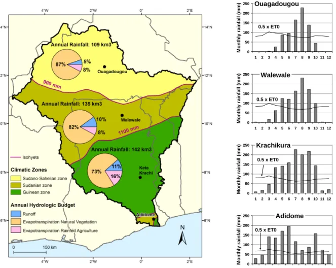
The temporal and spatial distribution of rainfall influences agriculture more than total rainfall. Towards the north, rainfall has a unimodal distribution from May to September and the rainy season becomes increasingly. In the south, rainfall is distributed bimodally with “long rains” from April to July and “short rains” from September to November (Figure 6). The risk of within-season dry spells influences cropping choices (see below).
This north to south gradient has been used as the basis for delineating the following agro-ecological zones based on the FAO classification (FAO 1996) (Figure 6):
The Sahel, located in the northernmost part of the basin, defined as receiving less than 500 mm annual precipitation. The Sahel is a zone of rangeland where livestock herding is the primary activity, complemented with the drought-resistant crops, millet and cowpea;
The Sahelo-Sudan, covering most of Burkina Faso and a small part of Mali, defined as receiving 500 - 900 mm annual rainfall. Millet, sorghum and maize are the main cultivated food crops, with cotton, groundnuts and some sedentary cattle for cash income;
The Sudan, including the northern half of Ghana, and those parts of Côte-d’Ivoire, Benin and Togo that lie within the Basin, and defined as receiving between 900 and 1,100 mm annual rainfall. This is a transition zone with production of both cereals and root crops. Some cattle is present seasonally; and
The Guinean zone, covering the southern part of Ghana, receiving in excess of 1,100 mm annual rainfall. Yam, cassava and plantain are the main crops.
Objectives
CPWF Project Report
Page | 24
0 50 100 150 200 250 1 2 3 4 5 6 7 8 9 10 11 12 M o n th ly r a in fa ll (m m ) 0.5 x ET0 Ouagadougou 0 50 100 150 200 250 1 2 3 4 5 6 7 8 9 10 11 12 M o n th ly r a in fa ll (m m ) 0.5 x ET0 Walewale 0 50 100 150 200 250 1 2 3 4 5 6 7 8 9 10 11 12 M o n th ly r a in fa ll (m m ) 0.5 x ET0 Krachikura 0 50 100 150 200 250 1 2 3 4 5 6 7 8 9 10 11 12 M o n th ly r a in fa ll (m m ) 0.5 x ET0 AdidomeFigure 6. The agro ecological zones with a summary of the water account in the Volta basin, and the distribution of rainfall in four stations along the south-north gradient. ET0 is the reference (or potential) evapotranspiration. The intersection of the 0.5 ET0 line with the rainfall distribution indicates the length of the growing season (map by BFP Volta with data from CRU) (De Condappa et al. 2008).
Surface water in the Volta is largely concentrated in the reservoirs of the hydropower schemes (Bagre, 1700 Mm3; Kompienga, 2025 Mm3; and Lake Volta, 148,000 Mm3). A smaller amount of surface water is stored in about 1100 small reservoirs (90% located in Burkina Faso) that are used for small-scale irrigation, household and cattle watering. Their total storage capacity is 232 Mm3. Lake Volta is a major component of the aquatic system, with a surface area of 8,500 km2, in which water has a residence time of 3 years. Many of the rivers of the Upper Volta basin used to dry up during part of the year before being regulated by the construction of the hydropower schemes Bagré on the Nakambe River and Kompienga in the basin of the Oti River.
Major water management issues focus on surface water, on the impact of the development of small reservoirs, and on the possible effects of climate change on the operation of the Lake Volta hydropower system and on the livelihoods of more than 70,000 fishers.
Groundwater resources are poorly understood but appear to be under-exploited. Groundwater recharge is estimated to be 12.6km3/y or 3.7 percent of rainfall (Martin and van de Giesen, 2005). FAO (Aquastat 2002) gives a figure of 36.0 km3/y for the groundwater resource in Ghana and Burkina Faso, with good yields from the limestone aquifer up to 184 m3/h compared with the yield from hard rock (less than 6 m3/h). Most boreholes are used for rural domestic supply and give access to good quality water to about 44% of the population. The conservative estimate of groundwater use of 88 Mm3/y corresponds to about 0.7 % of average
Objectives
CPWF Project Report
annual groundwater recharge (Martin and van de Giesen, 2005), which leaves ample opportunities for development.
Potential for groundwater development was estimated through a combination of the amount of groundwater recharge, together with the accessibility to the resource and whether its development was worthwhile (Martin and van de Giesen, 2005). The study identified regions with good potential such as the north-western edge of the basin, and from the eastern shore of the Volta Lake to the eastern corner of Burkina Faso. Some unacceptably high concentrations of fluoride and arsenic occur locally in some boreholes in Burkina Faso.
The fluctuation of the rainfall regime in West Africa has major implications for water resource management. The decades of the 1950s and 60s were relatively wet, while the 1970s and 80s were drier (Figure 7). A comparison of these two time periods for the main tributaries of Lake Volta, the White Volta and the Oti, illustrates the impact of rainfall variation and related factors. In the 1950s and 60s, with higher rainfall, catchments were more densely vegetated, populations were smaller and land use was less intense. In the drier 1970s and 80s, populations were larger, land use more intensive, and land degradation more severe. Mean stream flows were substantially reduced in the latter time period: by 32% at Saboba on the Oti River and by 23% at Nawuni on the White Volta near Lake Volta (Gyau-Boakye and Tumbulto 2000). The change in runoff from the wet to dry period was not uniform across the Basin: the runoff coefficient increased during the dry period in the upper basins where annual rainfall is <750 mm/yr, resulting in sometimes higher discharge, while it has not changed in the lower basins (>750 mm/yr) where the coefficient was already higher than in the north.
Figure 7. Normalized rainfall anomaly index for the West African Sahel (1896-2000) with a mean value computed for 1921-2000. The normalized anomaly index for a given year is the departure from the mean in mm, divided by the standard deviation (in mm) of the rainfall distribution for the whole period. Source: L’Hôte et al., 2002, as shown in Lemoalle, 2007.
3.2.Water use
A detailed water account for the different agro-ecological zones and the sub-basins is presented in Figures 6 and 8 respectively. Natural vegetation, mostly savannah grasslands, uses the major part of the rainfall (around 80%) throughout the basin. Run-off increases from less than 5% in the northern part of the basin to >10% in the south. Woodland appears as a water consumer only in the southernmost part of the basin. The total available streamflow in the Basin is about 32 km3 per year during the period 1990 - 2000.
Objectives
CPWF Project Report
Page | 26
irrigation. Burkina Faso has developed small-scale irrigation throughout the country, and some hydropower schemes near its downstream border (Bagré and Kompienga dams).
With Lake Volta and its Akosombo-Kpong hydropower scheme, Ghana aims primarily at producing energy. An annual volume of about 37 km3 of fresh water was discharged through the turbines and into the sea in the late 1990’s, which is above the average inflows during the period 1990 – 2000 and resulted in low lake levels. Another hydroelectric plant is planned at Bui on the Black Volta. There is sufficient rainfall over most of Ghana for a satisfactory production of rain-fed agriculture, except in two regions: the northern regions where some small reservoirs and dug outs have been constructed, and in the south near the coast where supplemental irrigation from the reservoirs or Lake Volta is needed.
3.2.2Domestic use
From the population in the Basin, the domestic water demand has been estimated as 156 Mm3/yr in 2005. Large cities in the south, and Ouagadougou in the north, are largely supplied by surface water. Underground water from boreholes is usually considered a good quality or safe water. It supplies most of the large cities in the north and the rural population of the Basin. Although the situation is improving rapidly, many households in the Basin do not have access to this good quality water (see Figure 25), and the present use of underground water has been estimated as 88 Mm3/yr (Martin and van de Giesen, 2005).
Even with increased urban populations in the near future, the demand for domestic water remains a small fraction of the total resource. The same applies to the watering needs for cattle and livestock, which are widespread in the basin, with a total annual demand of 70 Mm3/yr (Clanet, 2008).
3.2.3Rain-fed agriculture
Rain-fed agriculture uses only 14% of the total rainfall of the total basin area. A combination of factors contributes to the gap between potential and observed water productivity. Some of these factors are directly related with the water availability: the inter-annual rainfall variability (droughts) and the intra-seasonal variability (dry spells) lead to low yields, but also a poor water holding capacity. Poor nutrient contents of most soils in the Basin also contribute to the low yields.These low nutrients result from the weathering of the parent rocks by tropical climate and subsequent leaching of the soils (Bationo et al. 2008).
In the near future, gains in the productivity and water productivity particularly in the North of the country of the rain fed agriculture appear to be the main prospect for the food self sufficiency in the basin.
Objectives
CPWF Project Report
Figure 8. Water accounting in the different sub-basins of the Volta River. Map by BFP Volta with data from CRU for rainfall, Volta Hycos and SIEREM for river discharge, MAHRH-Burkina Faso, MOFA-Ghana and FAO for land use (de Condappa et al., 2008).
3.2.4Irrigation
As in most other regions of Africa, the irrigated area in the Volta basin is only a small fraction of the total cultivated area, less than 0.5%, and also a small fraction of the irrigation potential. Even the areas for which irrigation water is available from the Bagré and Akosombo/Kpong dams have not been fully exploited. Nevertheless, many of the small farmers in the drought-prone areas of the Basin consider access to dry season irrigation as a means to alleviate vulnerability and poverty and to increase food production (Ducommun et al. 2005).
The formal, state-owned, irrigation schemes amount to 13,000 ha and 6,500 ha respectively in Burkina Faso and Ghana. The associated total water demand is 509 Mm3/yr. It is planned to involve commercial companies as these areas are not all fully exploited by the small farmers. Social, cultural and economic reasons may contribute to the present situation. The policy documents for the development of African agriculture issued by the African Union/NEPAD (2003) and the European Commission (2007) focus mainly on the technical feasibility and on the investments required, but do not take into account the social aspects of the
Objectives
CPWF Project Report
Page | 28
About 1,400 small reservoirs have been developed in Burkina Faso and northern Ghana. Approximately 1,100 are within the basin, with a storage volume estimated as 232 Mm3. They contribute to dry season vegetable production over about 10,000 ha, and usefully complement rain-fed production. The active informal urban and peri-urban irrigation, mostly devoted to vegetable production, remains poorly documented but is rapidly expanding.
The impact of the present and future development of small reservoirs in the upstream part of the basin has been taken into account in the development of the water allocation model, both at the basin and sub-basin scales. A sharp increase (10 % increase in the number of small reservoirs per year during 20 years would decrease the inflow to Akosombo by less than 1 km3 per year at the end of the period. But other water users, and notably Bagré and the existing small reservoirs in the upper sub-basins, may suffer earlier more frequent unsatisfied demands (De Condappa et al., 2008).
3.2.5Other uses
A main feature of the basin is Lake Volta, a hydroelectric reservoir with an area of 8,500 km2 and a residence time of 3 years. The dam was closed in early 1965, which severely impacted the downstream population and its environment. It has been complemented since by the smaller Kpong reservoir (0.19 km3), a few kilometers downstream. The water released through the turbines amounted to 37 km3 per year at the beginning of the 2000s. Since 1970, a decrease in rainfall over the basin and probably an increase in electricity production have contributed to a reduction in the water stored in Lake Volta. The energy produced, around 8 billion kWh, is an important contribution to the national income, and this water use is a priority for Ghana. A major threat to the Lake and hydropower is the presence of the water hyacinth (Eichhornia crassipes) in the lower Oti River, one of the main tributaries to the lake. The plant is known to be detrimental to the turbines if taken up in the water intakes.
Lake Volta is also home for 70,000 fishermen and their families. With an area of 8,500 km2, Lake Volta has loses about 2 km3/yr through net evaporation (rain minus evaporation) during the period 1990-2000 (van de Giesen et al., 2001; de Condappa et al. 2008).
In Burkina Faso, the reservoirs Bagré, for both hydropower and irrigation, and Kompienga (Table 2), only for hydropower generation, contribute also to some inland fisheries. Overspills of the dam at Bagré has caused damage for the downstream populations. Such floods probably result from a recent increase in the runoff coefficient in the watershed, which was not taken into account in the dam design.
Table 2. The main hydropower schemes in the Volta basin.
Reservoir Volume (Mm3) Dateconstruction finished Energy/year (GWh) Akosombo/Kpong(GHA) 148,000 1965 4,800 Bagré(BFA) 1,700 1993 33-44 Kompienga (BFA) 2,500 1990 48
Objectives
CPWF Project Report
4.
FARMING SYSTEMS AND FOOD PRODUCTION
Rain-fed production of food and cash crops is largely dominant in the Basin where only a very small proportion of the cultivated area is irrigated. Meat production from cattle, small ruminants and poultry may be considered as partly derived from rain-fed cultivated or wild biomass. Fish catch is also to be taken into account, both as a food production and as an important social and economic activity, especially from the large Lake Volta with more than 70,000 fishers.
As food production is especially vulnerable in the north and central parts of the Basin, due to the rain variability, we have focused on the rain-fed cereal production in this part of the Basin prone to droughts and dry spells. Rain fed agriculture is the main tool for improvement in food security (Rockstrom and Barron, 2007). It is also the activity of the majority of the poor rural populations. The challenge is to improve the use of the available rain water.
Objectives
CPWF Project Report
Page | 30
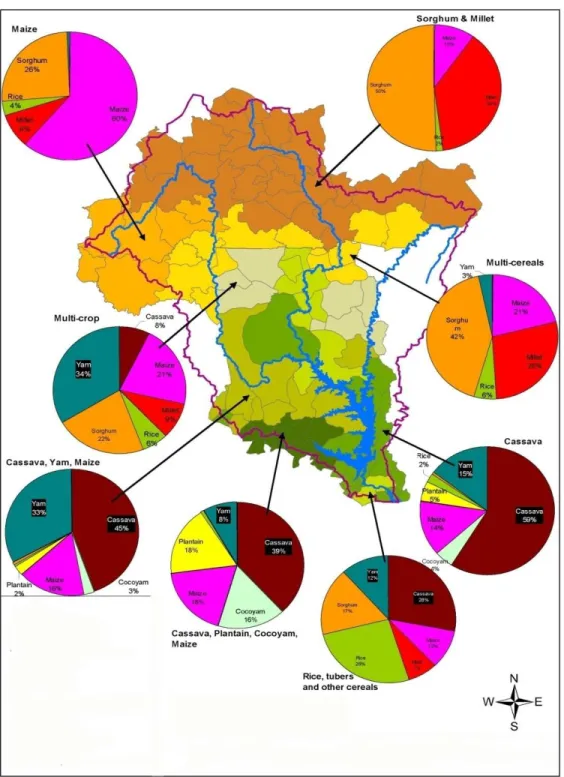
Figure 9. The main cropping systems in the Volta basin. Map by BFP Volta with production data from MAHRH and MOFA data for 1992-2000.
Objectives
CPWF Project Report
0% 10% 20% 30% 40% 50% 60% 70% 80% 90% 100%Sudano-Sahelian Sudanian Guinean
Climatic zone % o f c u lt iv a te d a re a Other Yam Cassava Maize Sorghum Millet
Figure 10. The North-South gradient in agro ecological zones and agricultural systems.
4.1.Rainfed farming systems
Distribution of the main crops varies across the agro-climatic regions of the Basin, mainly as a function of rainfall and soil characteristics, with a successive north-south dominance of millet, sorghum, maize, which are replaced by cassava, yam and plantain in the south (Figure 9 and Figure 10). The overall low production of rain-fed crops in the Basin results from a combination both of a limited use of the arable land and low yields(Figure 12).
4.1.1The use of arable land
While it is generally accepted that around 50% of a country in West Africa is arable, only a small fraction is cultivated in the countries of the Basin (Table 1)(FAO, Aquastat,2005). The relative increase in cultivated area has been closely related with the demography in South-West Burkina Faso for the past 30 years, with no net increase of cultivated area per rural inhabitant (Serpantié, 2003). More recently, in the Volta basin of Burkina Faso and Ghana, the rate of increase of the cultivated area is very similar to the increase rate of the total population between 1992 and 2003 (Figure 11), although there is an indication of a slight increase of cultivated area per rural inhabitant.
0 5 1 0 1 5 2 0 2 5 P ro d u c ti o n ( k c a l1 0 ^ 1 2 ) a n d p o p u la ti o n ( M h a b ) 0 1 2 3 4 5 C u lt iv a te d a re a ( M h a ) P ro d u c tio n k c a l 1 0 ^ 1 2 P o p u la tio n (M h a b ) C ro p p e d a re a ( M h a )
Objectives
CPWF Project Report
Page | 32
Some arable land is available at the basin scale for further development of cultivation, taking into account other uses, and especially livestock keeping. This availability leads to some migrations and new settlements within the countries of the Basin.
4.1.2Low yields
The low yields (Figure 12) result from a number of reasons: Water availability (variability of rainfall in time and space); Poor and degraded soils, with little or no input of fertilizers; and Lack of man power and low work efficiency.
Water availability has been discussed in part in the previous chapter. Water harvesting and soil and water conservation techniques are available to improve the effective use of rain water by crops, especially by increasing the water holding capacity of the soil by using mulches and incorporating crop residues. The farmers also have their fields scattered around the village, so as to minimize the risk resulting from the highly variable spatial distribution of the rain, the distance of independence being approximately 1000m for almost all storms (Sivakumar and Hatfield, 1990).
Most African soils are poor compared to other parts of the world. Lack of volcanic rejuvenation has caused the continent to undergo various cycles of weathering, erosion and leaching, leaving soils poor in nutrients (Smaling 1995; Smaling et al. 1999). In addition to low inherent fertility, the nutrient balances of African soils are often negative indicating that soils are progressively mined. Whereas in the developed world, excess applications of fertilizer and manure have damaged the environment, insufficient use of fertilizer is one of the causes for environmental degradation in Africa (Bationo et al, 1991, 2006).
Simulation with the Decision Support System for Agrotechnology Transfer (DSSAT) for 11 soils, with fertilizer (N40, P13 kg/ha), or without has shown that a significant yield increase could be obtained with moderate application of fertilizers on most soils of the basin (Fisher and Lemoalle, 2008). The increase ranged from twofold for the better soils to almost sixfold for the poorest soils (Figure 13). The results also point to a distinction between the southern region, where yields vary little with latitude (rainfall is abundant), and the central and northern part of the basin where yields decrease rapidly with increasing latitude, indicating a water constraint and a higher susceptibility to climate change. In these drier regions, rain and other factors become more limiting than nutrients.
Field observations in the Sahel have also indicated the high potential of fertilizer use, including local sources of phosphate (Bationo, 1991; Bationo et al., 2008), or micro additions of fertilizers. On-farm trials in Northern Ghana have shown an astonishing fourfold increase in maize, and more than twofold increase in millet or sorghum with micro or normal additions of fertilizers (provisional results of CP 5 of the CPWF, in press).
These technical solutions may however prove impractical because of the social and cultural environment: risk avoidance by small farmers, land tenure insecurity, lack of access to reasonable credit, to market.
A simulation of farmers’ behavior and needs in the central plateau of Burkina Faso points to three variables that may help to a more sustainable agriculture: credit, subsidized fertilizers and land tenure (Ouédraogo, 2005).
Objectives
CPWF Project Report
Objectives
CPWF Project Report
Page | 34
In this heavily populated area of the Central Plateau, where fallow is no longer practiced because of demographic pressure, credit may help the poor in developing more efficient practices. In the simulation, cheaper prices of fertilizers were not sufficient by themselves, even when prices are cut by 50%, but additional aid from credit was required. The present land tenure system, between modern legal law and traditional allocation, is a major obstacle to innovation and investment. In the context of the risk-avoidance strategies of poor farmers, investing in fertilizers increases the risk, so that they need the incentive of stable prices as well as efficient insurance mechanisms to allow them to make the necessary investment. Farmers also consider the lack of manpower, of draught power and of proper tools (plough, carts) major constraints to increased production and yield.
Yam, cassava, and plantain are cultivated in the basin where the rainfall exceeds 1,000 mm/yr and where there is a lower impact of dry spells (Figure 9 and Figure 12). They provide most of the food staples of in the southern part of the basin.
4.2.Other cropping systems
Peri- and intra- urban cultivation is an important component of vegetable production, with an estimated 45,000 ha in and around the main cities in Ghana. Such an area ranks peri-urban cultivation as the main irrigated system in the Basin, when compared with the 10,000 ha irrigated by small reservoirs. Urban production is mostly based on informal irrigation using a waste water. As both the size and the number of cities in the Basin will increase in the future, this activity is likely to develop as well. The research already under way by IWMI and the CPWF (PN 38 and PN 51) on the impact of irrigation by waste water on food safety is particularly relevant in order to improve the health security.
Figure 13. Grain yields at 50 and 20 percent probabilities for simulated crops of maize on a 9-degree transect on the meridian of Ouagadougou (1.53ºW) in the Volta Basin, West Africa, using the maize submodel of the DSSAT4 crop simulation package (Jones et al. 2003). The planting rules, the agronomy and the soil groupings are explained in Fisher and Lemoalle 2008. Soil groups: 1= coarse sand, 2= fine sand and sandy loam, 3= loam.
No fertilizer N45P13 0 1000 2000 3000 4000 5000 6 9 12 15 0 1000 2000 3000 4000 5000 6 9 12 15 0 1000 2000 3000 4000 5000 6 9 12 15 0 1000 2000 3000 4000 5000 6 9 12 15 M a iz e y ie ld , k g /h a 5 0 % p ro b a b il it y 2 0 % p ro b a b il it y Latitude °N Soil group 1