PhD Dissertation
International Doctorate School in Information and
Communication Technologies
DISI - University of Trento
A
DVANCED
P
RE
-P
ROCESSING AND
C
HANGE
-D
ETECTION
T
ECHNIQUES FOR THE
A
NALYSIS OF
M
ULTITEMPORAL
VHR
R
EMOTE
S
ENSING
I
MAGES
Silvia Marchesi
Advisor:
Co-Advisor:
Prof. Bruzzone Lorenzo
Dott. Bovolo Francesca
v
Abstract
Remote sensing images regularly acquired by satellite over the same geographical areas (multi-temporal images) provide very important information on the land cover dynamic. In the last years the ever increasing availability of multitemporal very high geometrical resolution (VHR) remote sensing images (which have sub-metric resolution) resulted in new potentially relevant applications related to environmental monitoring and land cover control and management. The most of these applications are associated with the analysis of dynamic phenomena (both anthropic and non anthropic) that oc-cur at different scales and result in changes on the Earth surface. In this context, in order to aquately exploit the huge amount of data acquired by remote sensing satellites, it is mandatory to de-velop unsupervised and automatic techniques for an efficient and effective analysis of such kind of multitemporal data.
In the literature several techniques have been developed for the automatic analysis of multitem-poral medium/high resolution data. However these techniques do not result effective when dealing with VHR images. The main reasons consist in their inability both to exploit the high geometrical de-tail content of VHR data and to model the multiscale nature of the scene (and therefore of possible changes). In this framework it is important to develop unsupervised change-detection(CD) methods able to automatically manage the large amount of information of VHR data, without the need of any prior information on the area under investigation. Even if these methods usually identify only the presence/absence of changes without giving information about the kind of change occurred, they are considered the most interesting from an operational perspective, as in the most of the applications no multitemporal ground truth information is available.
Considering the above mentioned limitations, in this thesis we study the main problems related to multitemporal VHR images with particular attention to registration noise (i.e. the noise related to a non-perfect alignment of the multitemporal images under investigation). Then, on the basis of the re-sults of the conducted analysis, we develop robust unsupervised and automatic change-detection me-thods. In particular, the following specific issues are addressed in this work:
1. Analysis of the effects of registration noise in multitemporal VHR images and definition of a method for the estimation of the distribution of such kind of noise useful for defining:
VHR images.
2. Detection and discrimination of multiple changes in multitemporal images; this techniques allow one to overcome the limitation of the existing unsupervised techniques, as they are able to iden-tify and separate different kinds of change without any prior information on the study areas.
3. Pre-processing techniques for optimizing change detection on VHR images; in particular, in this context we evaluate the impact of:
a. Image transformation techniques on the results of the CD process;
b. Different strategies of image pansharpening applied to the original multitemporal images on the results of the CD process.
For each of the above mentioned topic an analysis of the state of the art is carried out, the limita-tions of existing methods are pointed out and the proposed solulimita-tions to the addressed problems are described in details. Finally, experimental results conducted on both simulated and real data are re-ported in order to show and confirm the validity of all the proposed methods.
Keywords
Ringraziamenti
Con questa tesi si chiude un importante capitolo della mia vita, iniziato quasi dieci anni fa.
Da studentessa universitaria prima e da PhD Student poi ho vissuto intensamente questo ambiente universitario. Le giornate trascorse su libri, paper, presentazioni, progetti mi hanno fatta crescere e maturare in maniera profonda.
Per tutto questo devo ringraziare in primo luogo mamma e papà, genitori davvero speciali, che mi hanno sempre spronata, appoggiata, incoraggiata nei momenti di sconforto e, è bello dirlo, anche ammirata quando ho conquistato i miei primi piccoli successi. Con loro non posso non menzionare il mio fratellone Giovi, che ha dato un grosso contributo allo sviluppo del mio spirito critico, alimentando costruttive discussioni davvero difficili da intraprendere con chiunque altro. E con lui nonna e zia, che con orgoglio hanno seguito questi miei anni di crescita.
Ringrazio il mio Matteo,conosciuto all’inizio di questo capitolo e che mi accompagnerà fino alla fine della storia. ‘Perchè con lui la mia vita è ancora più meravigliosa’.
Un grazie va al prof, Lorenzo, che mi ha dato l’opportunità di affrontare il dottorato, di conoscere questo mondo, di espormi pubblicamente, di imparare a difendere la mia idea, il mio lavoro. Assieme a lui ringrazio Francesca per i consigli e le discussioni scientifiche.
Contents
CHAPTER 1: INTRODUCTION ... 1
1.1.OVERVIEW ON THE LAST GENERATION OF REMOTE SENSING SYSTEMS ... 1
1.1.1 VHR imaging systems ... 2
1.2.MULTITEMPORAL VHR IMAGES: APPLICATIONS AND RELATED PROBLEMS ... 3
1.3.OBJECTIVES AND NOVEL CONTRIBUTIONS OF THE THESIS ... 5
1.4.STRUCTURE OF THE THESIS ... 8
CHAPTER 2: ANALYSIS OF MULTITEMPORAL VHR REMOTE SENSING IMAGES ... 9
2.1.INTRODUCTION ... 9
2.2.UNSUPERVISED CHANGE-DETECTION TECHNIQUES ... 10
2.2.1 Unsupervised change-detection techniques for VHR remote sensing images ... 11
2.3.REGISTRATION TECHNIQUES OF VHR REMOTE SENSING IMAGES ... 14
2.4.THEORETICAL BACKGROUND ... 16
PART I: REGISTRATION NOISE AND REGISTRATION TECHNIQUE... 19
CHAPTER 3: ANALYSIS AND ADAPTIVE ESTIMATION OF THE REGISTRATION NOISE DISTRIBUTION IN MULTITEMPORAL VHR IMAGES ... 21
3.1.INTRODUCTION ... 21
3.2.DESIGN OF THE ANALYSIS AND EXPERIMENTAL SETUP ... 23
3.2.1 Experiment 1: effects of increasing misregistration on unchanged pixels ... 24
3.2.2 Experiment 2: effects of increasing misregistration on changed pixels ... 24
3.2.3 Experiment 3: effects of misregistration at different scales ... 25
3.3.PROPERTIES OF REGISTRATION NOISE IN VHR IMAGES ... 26
3.4.PROPOSED TECHNIQUE FOR THE ADAPTIVE ESTIMATION OF THE RN DISTRIBUTION ... 30
3.5.EXPERIMENTAL RESULTS ... 33
3.5.1 Test site 1: urban and rural areas ... 34
3.5.2 Test site 2: industrial and rural areas ... 37
3.6.DISCUSSION AND CONCLUSION ... 37
CHAPTER 4: A REGISTRATION NOISE DRIVEN TECHNIQUE FOR THE ALIGNMENT OF VHR IMAGES ... 41
4.1.INTRODUCTION ... 41
4.2.PROPOSED METHODOLOGY ... 42
4.2.1 Automatic extraction of control points ... 42
4.2.2 Generation of the disparity map ... 43
4.2.3 Image transformation ... 44
4.3.EXPERIMENTAL RESULTS ... 45
4.3.1 Simulated data set ... 45
4.4.DISCUSSION AND CONCLUSION ... 49
PART II: CHANGE-DETECTION METHODS ... 51
CHAPTER 5: A CONTEXT-SENSITIVE TECHNIQUE ROBUST TO REGISTRATION NOISE FOR CHANGE DETECTION IN VHR MULTISPECTRAL IMAGES ... 53
5.1.INTRODUCTION ... 53
5.2.METHODOLOGY ... 55
5.2.1 Registration noise identification ... 55
5.2.2 Context-sensitive decision strategy for the generation of the final change-detection map ... 58
5.3.EXPERIMENTAL RESULTS ... 59
5.3.1 Data set description ... 59
5.3.2 Results: multiscale properties ... 62
5.3.1 Results: change detection on Data Set 1 (small images) ... 63
5.3.2 Results: change detection on Data Set 2 (large images) ... 66
5.4.CONCLUSION ... 67
CHAPTER 6: AUTOMATIC AND UNSUPERVISED DETECTION OF MULTIPLE CHANGES IN MULTITEMPORAL IMAGES ... 69
6.1.INTRODUCTION ... 69
6.2.NOTATION AND BACKGROUND ... 71
6.3.PROPOSED COMPRESSED REPRESENTATION OF THE CHANGE INFORMATION ... 73
6.3.1 Magnitude of Spectral Change Vectors ... 73
6.3.2 Direction of Spectral Change Vectors ... 73
6.3.3 Proposed Compressed Change Vector Analysis ... 74
6.4.PROPOSED TECHNIQUE FOR THE DETECTION OF MULTIPLE CHANGES ... 75
6.4.1 Separation of changed from unchanged patterns ... 75
6.4.2 Identification of different kinds of change ... 77
6.5.EXPERIMENTAL RESULTS AND DISCUSSION ... 78
6.5.1 Data set 1: Thematic Mapper images of Landsat-5 ... 78
6.5.2 Data set 2: Quickbird images ... 85
6.6.CONCLUSION ... 90
PART III: PRE-PROCESSING TECHNIQUES FOR OPTIMIZING CHANGE DETECTION ... 93
CHAPTER 7: IMAGE TRANSFORMATION FOR CHANGE DETECTION IN MULTISPECTRAL IMAGES ... 95
7.1.INTRODUCTION ... 95
7.2.IMAGE TRANSFORMATION TECHNIQUES ... 96
7.2.1 PCA and KPCA ... 96
7.2.2 ICA and KICA ... 97
7.3.CHANGE-DETECTION STRATEGIES ... 98
7.4.EXPERIMENTAL RESULTS ... 98
7.5.CONCLUSION ... 102
CHAPTER 8: ANALYSIS OF THE EFFECTS OF PANSHARPENING IN CHANGE DETECTION ON VHR IMAGES ... 103
8.1.INTRODUCTION ... 103
8.2.PANSHARPENING TECHNIQUES ... 104
8.3.ADOPTED CHANGE-DETECTION TECHNIQUE ... 105
8.4.UNSUPERVISED STRATEGY FOR THE EVALUATION OF THE IMPACT OF PANSHARPENING ON CHANGE DETECTION ... 106
8.5.EXPERIMENTAL RESULTS ... 107
8.6.CONCLUSION ... 110
CHAPTER 9: CONCLUSIONS ... 111
Chapter 1
1.
Introduction
In this chapter we make an introduction to the problem of performing multitemporal analysis on very high geometrical resolution images. In details, we report a brief overview on the last generation of satellite sensors that acquire very high geometrical resolution (VHR) images, and we present the applications related to the analysis of multitemporal VHR data. We also describe the most critical is-sue related to the analysis of such kind of data, giving motivations of the introduced work. In addition, we describe the specific objectives faced in the thesis and the novel contributions of it. Finally, we de-scribe the structure and organization of this thesis.
1.1.
Overview on the last generation of remote sensing systems
Remote Sensing (RS) is the science and art of acquiring information (spectral, spatial, temporal) about material objects, area, or phenomenon, without coming into physical contact with the objects, or area, or phenomenon under investigation [1]. A sensor is used to measure the energy emitted and re-flected from the object and transferred as electromagnetic radiation through the space. According to the source of the energy measured by the sensors, RS systems can be divided into two categories: pas-sive and active. The formers detect the reflected or emitted radiation from natural sources, while the latter make use of sensors that measure reflected responses from objects that are irradiated from artifi-cially-generated energy sources, such as radar systems. In addition, with respect to the wavelength re-gions in which the sensor measures the received quantity of energy, the remote sensing systems can be divided into: visible and reflective infrared systems (from 0.4 to 3 micrometers), thermal systems (from 3 to 14 micrometers) and microwave systems (from 0.1 to 100 centimeters).
VHR images are planned for the next years. In this thesis, optical very high geometrical resolution multispectral images provided by the last generation of sensors will be considered.
In the following paragraph we briefly recall the characteristics of the most popular VHR imaging systems, in which we are mainly interested in this work.
1.1.1VHR imaging systems
Geometric resolution refers to the satellite sensor's ability to effectively image a portion of the Earth's surface in a single pixel and is typically expressed in terms of Ground Sample Distance (GSD), which indicates the smallest unit that is mapped to a single pixel within an image. The resolu-tion of satellite images varies depending on the physical properties of the sensors used and the altitude of the satellite's orbit. The latest commercial satellites could acquire images with a GSD lower than 0.5 m (i.e. GeoEye-1), however, due to US Government restrictions on civilian imaging the data are commercialized only after decreasing the resolution till obtaining a GSD of at least 0.5 m. GSD for intelligence and military purposes may have a resolution of less than a centimeter with the potential for real-time (live) imaging.
The term VHR imaging systems usually refers to images with GSD lower than 1 meter, provided by the last generation of sensors. These systems have been developed starting from XXI century (i.e. Ikonos satellite launched in 1999 and Quickbird satellite launched in 2001); and they have been pre-ceded by the SPOT satellites, appeared starting from 1986 and characterized by a high geometrical resolution (10 m for the panchromatic band and 20 m for the multispectral ones). Before them the most popular multispectral sensors were the ones mounted on Landsat satellites (from 1 to 7). Landsat 7, the last satellite of the Landsat program, launched in April 1999, can acquire a panchromatic band with 15 m spatial resolution and seven multispectral bands (in the visible, near and thermal infrared) with 30 m spatial resolution (except for the thermal band which has 60 m of resolution).
In the following a list of the major VHR RS systems with the main characteristics of each is re-ported.
Ikonos: launched on September 1999, provides multispectral images (spectral channels of acqui-sition: blue, green, red and near infrared) with a spatial resolution of 3.2 m and panchromatic im-ages with a resolution of 0.82 m. Time of revisit is from 3 to 5 days depending on the latitude [2].
Eros A: launched on December 2000, provides only panchromatic images with a spatial resolu-tion of 1.8 m. Time of revisit is from 2.1 to 9.5 days depending on the latitude [3].
QuickBird: launched on October 2001, provides multispectral images (blue, green, red and near infrared) with a spatial resolution of 2.4 m and panchromatic images with a resolution of 0.6 m. Time of revisit is from 1 to 3.5 days depending on the latitude [2].
Spot 5: launched on May 2002, the last satellite of the SPOT family, provides multispectral im-ages (green, red, near infrared and mid infrared) with a spatial resolution of 10 m and panchro-matic images with a resolution that varies from 2.5 to 5 m. Time of revisit is from 2 to 3 days de-pending on the latitude [2].
Eros B: launched on April 2005, provides only panchromatic images with a spatial resolution of 0.7 m. Time of revisit is from 2.1 to 9.5 days depending on the latitude[3].
GeoEye-1: launched on December 2004 provides multispectral images (blue, green, red and near infrared) with a spatial resolution of 1.65 m and panchromatic images with a resolution of 0.41 m (degraded to 0.5 m for civil applications). Time of revisit is from 2.1 to 8.3 days [4].
RapidEye: launched in August 2008, made up of a constellation of 5 satellites containing identic-al instruments, provides multispectridentic-al images (blue, green, red, red edge and near infrared) with a spatial resolution of 5 m. Time of revisit is about 1 day [5].
WorldView-2: launched in October 2009, provides multispectral images (blue, green, red and near infrared, plus red edge, coastal, yellow and near infrared 2) with a spatial resolution of 1.8 m and panchromatic images with a resolution of 0.5 m. Time of revisit is from 1.1 to 3.7 days de-pending on the latitude [2].
Pleiades-1: will be launched in early 2011 and will reach a spatial resolution of 2 m for multis-pectral images (blue, green, red and near infrared) and of 0.5 m for panchromatic images. It will have a revisit time of 1 day once the complete constellation (Pleiades-1 and Pleiades-2) will be operating [6].
Pleiades-2: will be launched in 2012 and will complete the Pleiades constellation of satellites (same characteristics of Pleiades-1) [6].
GeoEye-2: will be launched in early 2013 and it will reach a spatial resolution of 0.25 m. Howev-er, restrictive licensing by the US government makes it likely that only the US Government and some of its allies will have access to imagery at the full design resolution [4].
Please note that all the described systems are in a polar sun-synchronous orbit and the reported spatial resolution value is referred at nadir.
1.2.
Multitemporal VHR images: applications and related problems
Very high geometrical resolution images acquired by modern remote sensing sensors mounted on board of the last generation of satellites are a very important information source for many potential applications related to environmental monitoring and land control and management. In particular, the increased spatial resolution (with respect to previous generation satellites) makes it possible to address many new applications related to the analysis of scenes at a local scale with a very high geometrical detail (e.g., urban areas and infrastructure analysis, precision farming, building detection, etc.). In this scenario, a very important domain is related to applications that require a regular analysis of a given geographical area for the detection of possible alterations or changes occurred on the ground. Possible applications are related to: monitoring of natural resources in order to define risk maps, analysis of changes occurred after natural disasters in order to derive damage maps at high resolution, building abuse discovering, etc [7].
Therefore, for a proper exploitation of VHR images in real applications related to extended areas, it is mandatory to develop effective automatic techniques that can properly handle the huge amount of available data and the high geometric content.
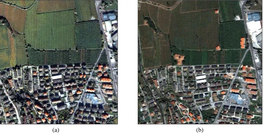
In order to give to the reader an idea of the differences between medium and very high geometrical resolution images, Figure 1.1 shows two images acquired over an area of the city of Trento (Italy) by the multispectral sensor mounted on Landsat5 satellite (Figure 1.1 (a)) and by the one mounted on the Quickbird satellite (Figure 1.1 (b)). Observing the two images it is simple to imagine the potentiality of new applications arisen from the high geometrical content of VHR data and the need of developing new and proper techniques for effectively manage such kind of data.
(a) (b)
Figure 1.1. True color composition of the remote sensing images acquired over the city of Trento (Italy) by mul-tispectral sensor mounted on (a) Landsat 5 satellite and (b) Quickbird satellite.
The problems related to the analysis of multitemporal VHR images faced in this thesis are specifi-cally related to the following aspects:
(a) (b) (c)
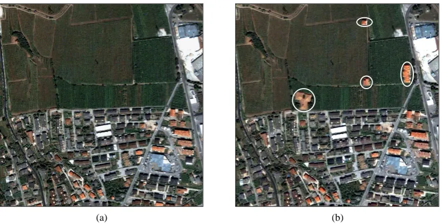
Figure 1.2. True color composition of the images acquired over the same geographical area of the city of Trento by the Quickbird satellite in: (a) October 2005 and (b) July 2006. (c) False color composition of the multitemporal images.
2. The detection of multiple changes (i.e., different kinds of change) in multitemporal remote sens-ing images is a complex problem (not only for VHR images). When multispectral images havsens-ing
B spectral bands are considered, an effective solution to this problem is to exploit all available spectral channels in the framework of supervised or partially supervised approaches [9]. However, in many real applications it is difficult/impossible to collect ground truth information for either multitemporal or single date images. On the opposite, unsupervised methods available in the lite-rature are not effective in handling the full information present in multispectral and multitemporal images. They usually consider a simplified sub-space of the original feature space having small dimensionality and thus characterized by a possible loss of change information.
3. The last generation of VHR multispectral sensors can acquire a panchromatic (PAN) image char-acterized by very high geometrical resolution and low spectral resolution (no spectral diversity and low capacity in distinguishing different kind of changes); and a set of multispectral (MS) im-ages with lower spatial resolution, and higher spectral resolution. In order to take advantage of both high geometrical and spectral resolutions in the change detection process, it is common prac-tice to apply a proper pre-processing, namely pansharpening (PS). PS merges the properties of panchromatic and multispectral data for spatial detail injection from PAN to MS, resulting in a set of images with both high spectral resolution and enhanced geometrical resolution. However, pan-sharpening can introduce in the images spatial artifacts and spectral distortions that can affect the accuracy of change-detection maps. Although several quality indexes have been proposed for evaluating pansharpening methods, they are not specifically conceived for CD applications [10].
1.3.
Objectives and novel contributions of the thesis
de-veloped for medium resolution images. In greater details, the following specific topics are considered in this work:
a) Analysis of the effects of registration noise in multitemporal VHR images in order to derive an adaptive estimation of it;
b) Registration techniques effective on VHR multitemporal images, which overcome the limitations of the techniques developed specifically for medium resolution images;
c) Techniques for the detection of changes in multispectral VHR images robust to the problems re-lated to registration noise and that consider the contextual information;
d) Automatic methods for the detection and separation of multiple changes in multitemporal images. Please note that for this specific topic the analysis has been conducted on both medium and VHR images, as no unsupervised techniques developed for medium resolution images exist able to separate different kinds of change, as previously pointed out;
e) Analysis of image transformation techniques for change-detection applications on VHR images; f) Analysis of the effects of pansharpening in change detection on VHR images.
In order to address the aforementioned issues, we developed novel approaches and techniques for the automatic analysis of VHR multitemporal images. The main goals of these methods are briefly de-scribed in the following:
a) Analysis and adaptive estimation of the registration noise distribution in multitemporal VHR im-ages
According to the problem related to the presence of registration noise described in the previous section in this thesis we aim at analyzing the properties of registration noise in multitemporal VHR images in order to formulate an adaptive technique for the explicit estimation of the distribution of re-sidual RN between multitemporal images. This distribution is a starting point for the development of novel registration techniques and change-detection techniques robust to such source of noise, as it will be presented in the following. This study is developed within a polar framework for change vector analysis (CVA) recently introduced in the literature for change detection in medium resolution mul-tispectral images [11]. In this context, the novel contributions of this work consist in: i) the analysis of the effects of registration noise in multitemporal and multispectral VHR images; ii) the definition of the properties of registration noise in VHR images; and iii) the formulation of an adaptive and distri-bution-free technique for the estimation of the distribution of the registration noise in the polar do-main.
b) A registration noise driven technique for the alignment of VHR images
the proposed procedure: (i) is effective in obtaining good registration accuracy on the most critical points of the images where misregistration has a high probability to results in the detection of false changes; and (ii) is not affected by the presence of changes between the two images.
c) A context-sensitive technique robust to registration noise for change detection in VHR multispec-tral images
One of the most important problems, as pointed out before, in the development of change-detection techniques for VHR data is represented by registration noise arising from a non-prefect alignment of the multitemporal images under investigation [8]. Another important problem in change detection on VHR images concerns the modeling of the spatial context information of the scene [13]. In order to overcome the aforementioned problems, in this thesis we present an adaptive context-sensitive technique, which: i) reduces the impact of registration noise in change detection on VHR multispectral images through a multiscale strategy; ii) considers the spatial dependencies of neighbor-hood pixels through the definition of multitemporal parcels (i.e. homogeneous regions both in space and time domain). As for the method presented in b), this technique takes advantages from the analy-sis conducted in a).
d) Automatic and unsupervised detection of multiple changes in multitemporal images
In relation with the problems of detecting and separating different kinds of change in an automatic and unsupervised way, in this thesis we present a framework for the detection of multiple changes in multitemporal and multispectral remote sensing images that allows one to overcome the limits of standard unsupervised methods. Please note that the problem of multiple changes has been faced in this thesis both for medium and very high resolution images, as also for medium resolution it has not been implemented in the literature. The framework is based on: i) a compressed yet efficient 2-dimensional (2D) representation of the change information; and ii) a 2-step automatic decision strate-gy. First the multidimensional feature space of SCVs is compressed into a 2-dimensional feature space without neglecting any available spectral band (and thus possible information about changes). Second, an automatic 2-step method for separating unchanged from changed patterns and distinguish-ing different kinds of change is presented.
e) Image transformation for change detection in VHR multispectral images
As stated before, in real change-detection problems pre-processing is often not sufficient to guar-antee the ideal condition in which radiometric changes in corresponding pixels on the multitemporal images are associated with true changes on the ground. Usually, residual components of noise (e.g. due to residual radiometric differences, residual misregistration, etc.) result in false alarms in the change-detection maps, which cannot be easily identified in the phase of post-processing [14].
f) Analysis of the effects of pansharpening in change detection on VHR images
The pansharpening procedure is commonly used on VHR images in order to merge the high geo-metrical content of the panchromatic channel with the spectral content of the multispectral ones. This procedure may result in artifacts that could be dangerous on the results of a change-detection process applied to the pansharpened images. In this thesis we aim at analyzing the impact of pansharpening on the accuracy of change detection investigating whether the improvement in geometrical resolution of change-detection maps given by pansharpening is significantly affected or not by artefacts introduced by the PS process in an unsupervised way. To this end five different multiresolution approaches are considered. A ranking of pansharpening techniques from the most to the less effective for CD is ob-tained by defining a novel unsupervised objective strategy based on similarity measures for compar-ing change-detection maps. In order to avoid the introduction of any bias in the analysis and to better understand the impact of pansharpening on change detection, the CD step is performed according to the standard change vector analysis (CVA) technique [15].
1.4.
Structure of the thesis
The thesis is organized into nine chapters. The present chapter gave a brief overview on the remote sensing systems with a particular attention to the last generation of very high geometrical resolution sensors. It presented the problems related to the analysis of multitemporal VHR data and introduced the motivation, the objectives and the main novel contributions of this thesis. The following chapters will describe in details the studies and methodologies developed in order to fulfil the objectives pre-sented in section 1.3.
Chapter 2 presents an exhaustive review of the state of the art related to the analysis of multitem-poral VHR images focusing the attention on the change-detection problem.
Then, after these two chapters of introduction and state of the art, the other chapters are divided into three main parts. The first one regards registration noise and registration techniques and it in-cludes chapter 3 and chapter 4. In chapter 3 an analysis of the effects of the registration noise is de-scribed and the properties of such kind of noise are derived. This analysis results in the definition of the strategy for the adaptive estimation of the RN distribution which is useful for both registration and change-detection methods. Chapter 4 presents the registration methods for VHR multitemporal im-ages that we developed according to the results of the analysis on RN performed in chapter 3.
The second part is related to change-detection methods and includes chapters 5 and 6. In chapter 5 we present the change-detection method we have developed taking advantage form the analysis con-ducted in chapter 3. This method is robust to registration noise and considers the contextual informa-tion; this aspect is very important when dealing with VHR images. Chapter 6 describes an automatic and unsupervised technique for the detection of changes. The main advantage of this algorithm is its ability of identifying and separating different kinds of change.
The third part involves an analysis of the pre-processing techniques for optimizing change detec-tion and includes chapter 7 and 8. In detail, chapter 7 presents an analysis of the effects of image transformation on the change-detection results; different image transformation techniques are consid-ered and compared. Instead, chapter 8 presents an analysis of the effects of pansharpening methods on the results of the change-detection process. Five different pansharpening methods are considered and compared.
Chapter 2
2.
Analysis of multitemporal VHR remote sensing images
This chapter presents a review on the techniques for the analysis of multitemporal VHR remote sensing images with particular attention to the process of detecting changes. In particular, the main characteristic of the very high geometrical resolution multitemporal images are highlighted and the limitations of the existing techniques for the analysis of medium resolution images are pointed out. Then the techniques proposed in the literature effective on VHR data are illustrated, by focusing on the methods for image registration and change-detection. Finally the change-detection techniques that are at the base of the most of the works proposed in this thesis are described in detail.
2.1.
Introduction
Several different automatic change-detection techniques have been proposed in the image processing and remote sensing literature[16], [17], [18]. These techniques have been successfully em-ployed in many different application domains, like analysis of growth of urban areas, cadastral map updating, risk analysis, damage assessment, etc. [18]. However, the most of the available methods are oriented to the analysis of images acquired by medium resolution (MR) sensors and result completely ineffective when dealing with images showing metric resolution (see section 1.2). The main limita-tions of CD techniques originally developed for MR images [18], when applied to VHR images con-sist in their inability both to exploit the high geometrical detail content of VHR data and to model the multiscale nature of the scene (and therefore of possible changes). In order to better exploit the spatial correlation among neighboring pixels and to get accurate and reliable CD maps (both in regions cor-responding to border or geometrical details and in homogeneous areas) it is necessary to integrate the spectral information with the spatial one and to model the multiscale properties of the scene. Further-more, the acquisition process of VHR images results in significant radiometric and geometric differ-ences between multitemporal images (due to differdiffer-ences in atmospheric conditions, in the acquisition angle, in shadows characteristics, etc.). Such differences are extremely more critical than in MR im-ages. Therefore, image pre-processing like image registration, geometric and radiometric corrections results in a critical task that strongly affect the quality of the CD process.
In the following section an overview on the unsupervised change-detection approaches is given. In particular, in section 2.2.1 a brief overview on the unsupervised CD techniques developed in the lite-rature for VHR images is given. Considering the importance of the pre-processing step in the analysis of multitemporal images in section 2.3 some of the existing techniques for the registration of VHR images are summarized,. Finally in section 2.4 the polar framework based on Change Vector Analysis that is at the base of most of the techniques proposed in this thesis is described.
For a detailed analysis of the state of the art of each specific problem treated in the thesis, please refer to the introduction section of each chapter.
2.2.
Unsupervised change-detection techniques
In the literature, two main approaches to change detection can be identified: the unsupervised and the supervised approach. The former requires a priori information on the investigated area and allows one to determine both the presence/absence and the kind of change occurred, while the latter does not assume availability of ground truth data and usually identifies only the presence/absence of changes. Even if the large part of unsupervised change detection does not produce information about the kind of changes, it has a high importance in the remote-sensing community since obtaining a priori infor-mation about land covers results often difficult or impossible. According to this consideration the un-supervised approach is the most interesting from an operational perspective. Moreover it is usually characterized by a very low computational burden.
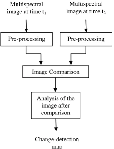
gives rise to different techniques [21], [22], [23]). In particular, considering optical multispectral im-ages (as in this thesis) the difference image is retrieved by applying the subtraction operator. After image comparison, a new image is obtained in which changes are empathized. In order to extract such changes a proper unsupervised image analysis technique should be applied. Among the unsupervised methods, the most widely used is based on the selection of a threshold that aims at separating changed from unchanged pixels. This threshold can be retrieved both manually by a trial and error procedure (according to the desired trade-off between false and missed alarms rate) or automatically (e.g. by analyzing the statistical distribution of the image after comparison, by fixing the false alarms proba-bility or following a Bayesian minimum-error procedure [15]).
Figure 2.1. Block scheme of a standard unsupervised change-detection approach
2.2.1Unsupervised change-detection techniques for VHR remote sensing images
From previous discussions it emerges that the techniques developed for medium resolution data are often not effective on VHR images and that, in order to overcome the limitation of these tech-niques, it is important to develop novel methodologies able to integrate the spectral information with the spatial one and model the multiscale properties of the scene. In the literature some methods exist capable to exploit the above-mentioned concepts [13], [24], [25], [26], [27], [28]. Usually, the change detection problem is faced after applying supervised classification to VHR images [29], [30]. The context information is exploited in the classification process according to segmentation techniques [31], [32] and to the extraction of texture feature, and the change detection map is obtained by com-paring the classification maps [33]. However, as previously pointed out, the supervised nature of these techniques [24] is critical from the application point of view, as ground truth information is often not available.
In the last five years some works have been published regarding unsupervised CD techniques for VHR images. These works can be divided into two main groups. Analyzing the literature, in fact, it is possible to note that the multitemporal problems related to the very high resolution of the images have been faced mainly through two different approaches: (i) multiscale-based methods; and (ii) image transformation-based methods. In the first case a decomposition of the images at lower scales is at the base of the proposed techniques for the detection of changes. Different strategies are then joined to the
Pre-processing Pre-processing
Image Comparison
Analysis of the image after comparison Multispectral
image at time t1
Multispectral image at time t2
multiscale analysis for extracting the information about changes, without decreasing the resolution of the final CD results. In the second approach the images are transformed through standard methods (i.e. principal component analysis, independent component analysis, etc.) in order to overcome the limits of ineffective pre-processing. New change detection schemes are proposed that integrate a transformation of the images in the CD strategy allowing one to work with data less affected by noise, in which different sources of change can be identified. In the following a brief description on some of these works is reported.
The most common strategy in the definition of unsupervised change-detection techniques for VHR data is represented by the multiscale analysis. Examples of works in this direction are:
F. Bovolo, A multilevel parcel-based approach to change detection in very high resolution multitemporal images [13]: this paper presents a novel parcel-based context- sensitive technique for unsupervised change detection in very high geometrical resolution images. In order to improve pixel-based change-detection performance, the author proposes to exploit the spatial-context in-formation in the framework of a multilevel approach. The proposed technique models the scene (and hence changes) at different resolution levels defining multitemporal and multilevel ―parcels‖ (i.e., small homogeneous regions shared by both original images). Change detection is achieved by applying a multilevel change vector analysis to each pixel of the considered images. The adap-tive nature of multitemporal parcels and their multilevel representation allow one a proper model-ing of complex objects in the investigated scene as well as borders and details of the changed areas.
W. Wang et al., Object-oriented change detection method based on multi-scale and multi-feature fusion [34]: to overcome the limitations of traditional pixel-level change detection methods and the difficulties of change detection of high resolution remote sensing images based on object-oriented analysis method, this paper presents an innovative object-object-oriented CD method based on multi-scale and multi-feature fusion for high resolution remote sensing images. Due to the good use of main characters of object-oriented thinking, this novel method can give full play to the cha-racteristics of high resolution data and get much better results than traditional methods for detect-ing changes from high resolution images.
T. Celik et al., Unsupervised change detection for satellite images using dual-tree complex wavelet transform [35]: in this paper, an unsupervised change-detection method for multitemporal satellite images is proposed. The algorithm exploits the inherent multiscale structure of the dual-tree complex wavelet transform (DT-CWT) to individually decompose each input image into one low-pass subband and six directional high-pass subbands at each scale. A binary change-detection mask is formed for each subband through an unsupervised thresholding derived from a mixture statistical model, with a goal of minimizing the total error probability of change detection. Then all the produced subband masks are merged by using both the intrascale fusion and the interscale fusion to yield the final change-detection mask. Extensive simulation results clearly show that the proposed algorithm not only consistently provides more accurate detection of small changes but also demonstrates attractive robustness against noise interference under various noise types and noise levels.
seeks to find a global optimal contour splitting the image into two mutually exclusive regions as-sociated with changed and unchanged classes, respectively. In order to increase the robustness of the method to noise and to the choice of the initial contour, a multiresolution implementation, which performs an analysis of the difference image at different resolution levels, is proposed.
L. Cannavacciuolo et al., A contextual change detection method for high-resolution optical images of urban areas [28]: this paper presents a method for unsupervised change detection of multiresolution images. The approach is based on the concept of a reference resolution, corres-ponding to the highest resolution in the dataset. The spatial relationships between the class labels are specified through a Markov random field model defined at the reference resolution. The adopted technique is based on a Bayesian approach with unsupervised parameter estimation. Data at reference and coarser resolutions are related by a fully specified statistical model. The estima-tion of the model parameter is carried by EM and by the maximum pseudo-likelihood criterion, and the classification is based on the resulting multiscale model.
M. Dalla Mura et al., An unsupervised technique based on morphological filters for change detection in very high resolution images [37]: in this work an unsupervised technique for change detection in very high geometrical resolution images is proposed, which is based on the use of morphological filters. This technique integrates the nonlinear and adaptive properties of the mor-phological filters with a change vector analysis (CVA) procedure. Different mormor-phological opera-tors are analyzed and compared with respect to the CD problem. Alternating sequential filters by reconstruction proved to be the most effective, permitting the preservation of the geometrical in-formation of the structures in the scene while filtering the homogeneous areas.
An alternative solution to the CD problem is represented by image transformation. This approach has been implemented in some works, like:
Niemeyer et al., Change detection using the object features [27]: in this work, the authors propose an unsupervised change detection and change classification approach based on the object features. Following the automatic pre-processing, image objects and their object features are extracted. Change detection is performed by the multivariate alteration detection, accompanied by the max-imum autocorrelation factor transformation. The change objects are then classified using the fuzzy maximum likelihood estimation (FMLE). Finally the classification of changes is improved by probabilistic label relaxation.
A. Nielsen et al., Kernel principal component analysis for change detection [38]: in this work, the authors introduce a kernel version of the principal component analysis (PCA) to detect changes over time. In particular, they use kernel PCA with a Gaussian kernel for detecting changes in data consisting of two variables which represents the same spectral band covering the same geographi-cal region acquired at two times. Unlike ordinary PCA, kernel PCA with a Gaussian kernel suc-cessfully finds the change observations in cases where nonlinearities are present.
Finally other significant automatic approaches exist, like:
moving window allows one to process through the whole image. Some investigations on the ro-bustness of the settings of the PCNN parameters are currently ongoing.
Most of these techniques implicitly assume that intrinsic differences between images due to the acquisition process can be neglected. They suppose that the images under investigation are radiometr-ically corrected and spatially co-registered. However, as previously pointed out, even after proper pre-processing, differences (particularly from a geometrical point of view) are significant and may strong-ly affect the quality of the change-detection map of the most of the presented methods. In greater de-tail, the unavoidable residual registration noise (misalignment) between images appears significantly higher in VHR images than in MR images. For this reason in order to obtain accurate CD results, it is important also to study effective techniques for the alignment of VHR data or to develop techniques robust to such kind of noise.
2.3.
Registration techniques of VHR remote sensing images
Image registration is the process of aligning two or more images acquired over the same geograph-ical area at different times, from different viewpoints, and/or by different sensors [12]. Let X1 and X2
be two multitemporal images acquired over the same geographical area at time t1 and t2, respectively.
Let X1 be the reference image and X2 the moving one. The objective of a registration technique is to
warp the moving image on the reference one in order to align them. This process is crucial in all im-age analysis tasks in which the final information is gained from the combination of various data sources like image fusion, change detection, and multichannel image restoration. The majority of the registration process consists of the following four steps: (i) feature detection (i.e. control points detec-tion - CPs); (ii) feature matching; (iii) transform model estimadetec-tion; and (iv) image resampling and transformation. In the first step salient objects are identified manually or automatically in the two im-ages under investigation (the reference and the moving one) and then represented by their point repre-sentatives (centers of gravity, line endings, corners, etc.) which are called control points (CPs); in the second step the correspondences between the features detected in the moving images and those de-tected in the reference image are established according to different feature descriptors and similarity measures. Then in the third step type and parameters of the function for the alignment of the moving image to the reference one (the mapping function) are estimated on the basis of the correspondences retrieved in the previous step. Finally the moving image is transformed in the fourth step according to the mapping function. How to implement each step is strictly related to the kind of images under in-vestigation and the specific application domain. For a survey of general image registration methods please refer to [12] and [40], in which the most relevant approaches to registration developed till 2003 are described.
age registration; and (d) local geometric distortions cannot be removed very well using traditional im-age registration methods even with enough CPs.
In order to face with these problems, in the literature some examples have been proposed for the registration of VHR data, often focused on specific applications and related to the kinds of data consi-dered [41], [42], [43]. For example in [41] a registration techniques for high resolution data is pro-posed for the specific case of hilly area; in [42] a feature matching method especially suitable for pre and post event images (i.e. strongly inhomogeneous image pairs) is described; in [43] an automatic registration technique of urban VHR images is presented.
In general, the new proposed techniques present novel methods for feature extraction and matching, often based on multiscale [41], [44] and local [45],[46] analysis, and apply advanced non linear trans-formations [47] to the images for better handle the geometric problems proper of VHR images. Inter-esting works in this direction are:
Y. Li et al., Pixel-based invariant feature extraction and its application to radiometric co-registration for multi-temporal high-resolution satellite imagery [44]: in this paper a robust fully automated method for relative radiometric co-registration is presented. First, a new low dimen-sional feature-point descriptor, called the Expanded Haar-Like Filter (EHLF) descriptor, is intro-duced. The EHLF has many desirable properties like flexible design, fast computation, and multi-scale description, while also being insensitive to variations in image quality. Then, two spatial matching schemes are proposed for increasing the percentage of correctly matched feature points. The first is based on a global affine model and the second utilizes dynamic local template fuzzy distance matching. Finally, precise pixel-to-pixel invariant feature points are extracted from a di-versity of image locations centered at matched local extrema points.
G. Danchao et al., Image registartion of high resolution remote sensing based on straight line feature [47]: in this paper a registration algorithm based on line feature is described. First, the lines in both images are extracted; then a modified iterated Hough transform is introduced to de-velop the correspondences of the lines; finally, the parameters for an affine transformation are evaluated, based on a similarity measure of the distance of corresponding straight line segments.
V. Arevalo et al., Improving piecewise linear registration of high-resolution satellite images through mesh optimization [46]: in this work the registration process of two images is obtained through an optimization of the local analysis based on triangular mesh; in particular, the optimiza-tion process consists in setting the appropriate topology upon the mesh vertices (once the mesh vertices position have been decided). In addition, the mutual information is used for measuring the registration consistency within the optimization process.
N. Taleb et al., An automatic image registration for applications in remote sensing [45]: in this paper the registration process involves an edge-based selection of CPs in the reference image, fol-lowed by the searching of corresponding CPs in the moving one based on local similarity detec-tion by means of template matching according to a combined invariants-based similarity measure. Finally the warping of the images is performed by using the thin-plate splines interpolation. In some works the feature extraction step is implements as a road extraction problem, as in:
Y. Zhao et al., Feature-based geometric registartion of high spatial resolution satellite imagery
[48]: this paper develops an improved feature-based geometric registration approach in which the CPs are efficiently selected automatically. First a modified watershed is used for image segmenta-tion, then regions are represented by centers of gravity and road intersections are considered as the main target to perform the CPs extraction. Finally the extracted points are matched through spatial relations and the moving image is transformed according to the derived model.
In other works the registration process is conducted by generating the so-called disparity map (i.e. a map of the value of the displacement for each pixel), that is a particular case of estimation of spatial transform between two images where the transform cannot be represented analytically [49], and then using the information present in this map for transforming the image, like:
M. di Bisceglie et al., Image registration using non-linear diffusion [50]: this work presents an image registration algorithm based on mutual information maximization and non-linear diffusion. It relies on a non-parametric estimation of the degree of dependency between reference and mov-ing image which is intrinsically more robust against possible deformations due to imagmov-ing geome-try and propagation disturbances. The approach based on non linear diffusion, nonetheless, has the advantage of producing a non-parametric discrete warping model which does not rely on a particular set of basis functions, and is therefore as much general as possible.
Borzì et al., Robust registration of satellite images with local distortion [51]: a new method for registration of remote sensing images in the presence of local distortion is described in this paper. The template matching is performed using as a measure the Cumulative Residual Entropy, then the mapping of the moving image to the reference one is represented by a field of displacements vectors (the disparity map). Before warping the images a vector regularization based on a diffu-sion equation is applied to the displacement vector, in order to produce a more homogeneous dis-placement map, reducing the presence of anomalous patterns.
Finally some works have been proposed also for the registration of images acquired by different sensors, like[52], [53], [54], [55] or for the specific problem of aligning the panchromatic channel to the multispectral ones [56], [57].
2.4.
Theoretical background
In this section the polar framework for Change Vector Analysis (Polar CVA) defined in [11] is de-scribed. This framework is at the base of most of the proposed analysis and methods of this thesis. Let us consider two VHR multispectral images X1 and X2 acquired on the same geographical area at
different times t1 and t2, respectively. Let X1 and X2 be two multidimensional random variables that
represent the statistical distributions of pixels in images X1 and X2, respectively. Let Xb t, be the
ran-dom variable representing the bth (b=1,…,B) component of the multispectral image Xt (t=1, 2) in the
considered feature space. Let us assume that these images do not show significant radiometric differ-ences, in particular let us consider that the spectral channels at the two times have the same mean val-ues (this can be easily obtained with very simple radiometric correction procedures) and are
co-registered. Let
n,c
be the set of classes of changed and no-changed pixels to be identified.In greater detail, n represents the class of no-changed pixels, while the set of the
K possible classes (kinds) of changes occurred in the considered area. As previously pointed out in order to detect changes between the two images a comparison should be performed according to a proper operator. When dealing with multispectral images, the comparison operator is usually the
vec-
1,..., K
c
c
ctor difference, which is applied to a B-dimensional feature space in order to give as input to the change-detection process all the relevant spectral information. This technique is known as CVA [58] and has been successfully used in many different application domains [59], [60], [61], [62]. CVA first computes a multispectral difference image (XD) subtracting the spectral feature vectors associated
with each corresponding spatial position in the two considered images X1and X2. Let XDbe the
mul-tidimensional random variable representing the spectral change vectors (SCVs) in the difference im-age obtained as follows [21]:
D 2 1
X X X (2.1)
In this treatment, for simplicity, we will assume that the CVA technique is applied only to two spectral channels of the considered multitemporal images, i.e., that a 2-D coordinate system is suffi-cient to completely describe the change-detection problem. However, the analysis can be generalized to the case of more spectral channels by considering more direction contributions for describing each SCV (see [11] for more details).
The spectral change vectors can be described through two different components: the magnitude and the direction, defined as:
where Xb,D is the random variable representing the bth component (spectral channel) of XD (b={1,2}).
However, the standard CVA technique considers only the magnitude component. In particular, in the standard CVA the B-dimensional problem described by XD is reduced to a 1-dimensional problem
by considering only the magnitude component of each SCVs.
According to the expression of
in (2.2), no-changed pixels present small magnitude values,whereas changed pixels show large values [11], [15]. Let x i j( , )be a generic pixel in spatial position
( , )i j in the magnitude image (i.e. the image reporting for each pixel the value of
of thecorres-ponding SCV). The CD map Y where changed and no-changed pixels are separated can be computed according to the following decision rule:
if ( , ) ( , )
if ( , )
c
n
x i j T y i j
x i j T
(2.3)
where y i j( , ) is the label associated to the pixel at spatial position ( , )i j in Y, and T is the decision
threshold. T can be defined either manually or automatically [15].
According to the given description it is clear that in the final change-detection map generated by the CVA approach all the pixels that have significant spectral differences in the two images under inves-tigation are reported. For this reason it is important to have images very similar to each other; there-fore effective pre-processing procedure (geometric and radiometric correction and registration) should be applied to them before CVA. In addition, no information about different kinds of change is pro-vided.
In the literature, few examples exist that consider both the magnitude and the direction of the SCVs in the generation of the CD map [11], [60], [63] most of them carried out in an empirical way. This variable contains important information, especially for discriminating among different kinds of change.
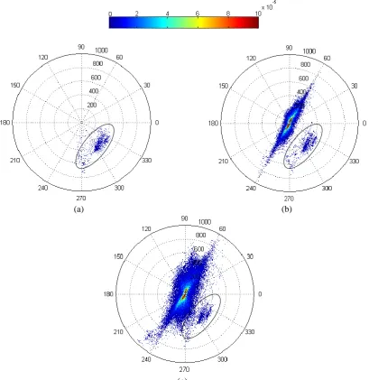
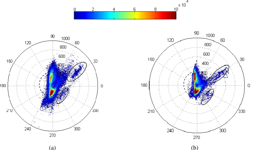
In this thesis we consider the information given by both the variables, taking advantages from a 2D representation of the spectral change vectors in a polar domain presented in [11]. In the following a description of such polar framework is given.
1,
2 2 1
1, 2,
2,
( D) ( D) and tan D
D X X X X
According to the definition of magnitude and direction given in (2.2), let us define the magnitude-direction domain MD (in which all the SCVs of a given scene are included) as:
0, max and 0, 2
MD
(2.4)where max is the highest magnitude of SCVs in the considered multitemporal dataset.
According to the previous definitions, the change information for a generic pixels in spatial position (i,j) can be represented in the magnitude-direction domain with a vector zij having components ij and
computed according to (2.2).
From the theoretical analysis reported in [11] and under the above-mentioned assumptions, it is ex-pected that in the polar representation no-changed and changed SCVs result in separated clusters. Un-changed SCVs show a low magnitude and are uniformly distributed with respect to the direction vari-able. In the polar domain the region associated with them is the circle of no-changed pixels Cn,
defined as:
, : 0 and 0 2
n
C T (2.5)
This circle is centered at the origin and has a radius equal to the optimal (in the sense of the theoreti-cal Bayesian decision theory) threshold T that separates no-changed from changed pixels. On the op-posite, changed SCVs are expected to show a high magnitude. The region associated with them in the polar domain is the annulus of changed pixelsAc, which is defined as:
, : max and 0 2
c
A T (2.6)
This annulus has inner radius T and outer radius given by the maximum among all possible magni-tudes for the considered pair of images (max). As changed SCVs show preferred directions according to the kind of change occurred on the ground, different kinds of changes can be isolated with a pair of
threshold values ( and ) in the direction domain. Each pair of thresholds identifies an annular
sectorSkof change in the annulus of changed pixelsAc defined as:
, : and 1 2,0 1 2 2
k k k k k
S T (2.7)
All the mentioned regions are depicted in Figure 2.2. Please refer to [11] for further details on both the polar framework and the general properties of SCVs in this kind of representation.
Figure 2.2. Representation of the regions of interest in the CVA polar framework
ij
1
k
2
k
k
c c
P
ART
I:
Chapter 3
3.
Analysis and adaptive estimation of the registration
noise distribution in multitemporal VHR images
1This chapter analyzes the problem of change detection in very high resolution (VHR) multitempor-al images by studying the effects of residumultitempor-al misregistration (registration noise) between images ac-quired on the same geographical area at different times. In particular, according to an experimental analysis driven from a theoretical study, the main effects of registration noise on VHR images are identified and some important properties are derived and described within the polar framework for change vector analysis (see section 2.4). In addition, a technique for an adaptive and unsupervised explicit estimation of the registration noise distribution in the polar domain is proposed. This tech-nique derives the registration noise distribution according to both a multiscale analysis of the distri-bution of spectral change vectors and the Parzen windows method. Experimental results obtained on simulated and real images confirm the validity of the proposed analysis, the reliability of the derived properties on registration noise, and the effectiveness of the proposed estimation technique. This technique represents a very promising tool for the definition of change-detection methods for VHR multitemporal images robust to registration noise.
3.1.
Introduction
The ever increasing availability of remote sensing images regularly acquired by satellites over the same geographical area makes the analysis of multitemporal data (and the related applications) one of the most interesting research topics for the remote sensing community. Multitemporal images represent a valuable information source for performing the detection of changes occurred on the Earth surface at different scales. Change-detection techniques generally compare two images acquired at different times by assuming that they are similar to each other except for the presence of changes oc-curred on the ground. Unfortunately, this assumption is seldom completely satisfied due to differences in atmospheric and sunlight conditions, as well as in the sensor acquisition geometry. In order to satis-fy the similarity assumption, pre-processing steps are required, including: image co-registration,
1
ometric and geometric corrections, and noise reduction. Among the others, co-registration plays a fundamental role as it allows one to obtain a pair of images where corresponding pixels are associated with the same position on the ground. However, in practice, it is not possible to obtain a perfect alignment between images acquired at different times. This may significantly affect the accuracy of the change-detection process. The co-registration procedure becomes more complex and critical (and therefore intrinsically less accurate) when very high resolution (VHR) images acquired by the last generation sensors (e.g. WorldView, Ikonos, Eros, Quickbird, SPOT-5) are considered. These images can be acquired with different view angles and often show different geometrical distortions that, even after proper geometric corrections, strongly affect the precision of the registration process, thus result-ing in a significant residual registration noise (RN). This noise sharply decreases the accuracy of the change-detection process.
In the literature large attention has been devoted to the development of advanced registration tech-niques, especially for what concerns medium resolution multitemporal and multisensor images [12], [40], [64], [65], [66]. Moreover, some studies exist on the effects of misregistration on the change-detection accuracy [8], [14], [67], [68], [69], [70] and on the development of change-change-detection tech-niques less sensitive to problems due to misregistration [71], [72]. Nonetheless, in our knowledge few attentions have been devoted to study the effects and the properties of registration noise in VHR im-ages.
This work aims at analyzing the properties of registration noise in multitemporal VHR images in order to formulate an adaptive technique for the explicit estimation of the distribution of residual RN between multitemporal images. This distribution is a starting point for the development of novel change-detection techniques robust to such source of noise. The present study is developed within a polar framework for change vector analysis (CVA) recently introduced in the literature for change de-tection in medium resolution multispectral images [11]. The definition of this framework is based on the analysis of the distribution of spectral change vectors (SCVs) computed according to the CVA technique in the polar domain. In this context, the novel contributions of this work consist in: i) the analysis of the effects of registration noise in multitemporal and multispectral VHR images according to the study of the statistical distribution of SCVs; ii) the definition of the properties of registration noise in VHR images; and iii) the formulation of an adaptive and distribution-free technique for the estimation of the distribution of the registration noise in the polar domain. This last technique exploits the Parzen windows estimation procedure and takes advantage from both a multiscale decomposition of multitemporal images and the properties derived in the first part of this work. The experiments car-ried out on simulated and real multitemporal images confirm the validity of the theoretical analysis and the effectiveness of the proposed technique, which represents a valuable tool for the development of reliable change-detection techniques for multitemporal and multispectral VHR images. It is worth noting that the proposed method can be suitable also for the analysis of optical data at lower resolu-tion, however we consider only very high geometrical resolution images as the impact of misregistra-tion on this kind of data is more relevant. For a descripmisregistra-tion of the framework proposed in [11] and used in this chapter and for an overview on the notation used in the following sections please refer to section 2.4.
technique for the estimation of the registration noise. Finally, section 3.6 draws the conclusions of this work.
3.2.
Design of the analysis and experimental setup
The objective of this work is to study the effects of misregistration within the framework presented in section 2.4 in order to derive its properties and to define a procedure for an adaptive estimation of the distribution of registration noise. As previously mentioned, residual misregistration affects multi-temporal data and represents an important source of noise. In particular, this noise becomes more re-levant when dealing with VHR images, as the process of co-registration is more complex and critical. Indeed, images acquired by VHR sensors of the last generation can be acquired with different view angles and often show different geometrical distortions that strongly affect the registration process. Thus, they result in a significant amount of residual registration noise. For this reason, it is very im-portant to study the properties of registration noise and to define techniques for estimating its distribu-tion (which is a valuable informadistribu-tion to be given as input to CD methods).
RN is due to the comparison of pixels that do not represent the same area on the ground in images acquired over the same geographical area at different times. In particular, the most critical component of RN is related to the pixels that at the two dates belong to different objects/classes on the ground (as discussed in the next section) due to the misalignment between the two images. In fact, these pixels show a behavior similar to the one of real changes, causing misclassification effects in the change-detection process. It follows that it is important to identify these pixels and separate them from pixels associated with real changes in the multitemporal data analysis.
The residual registration noise can be modeled as the effect of different types of transformations between the images, such as scale variation, ro