https://doi.org/10.5194/bg-14-2755-2017 © Author(s) 2017. This work is distributed under the Creative Commons Attribution 3.0 License.
Changing patterns of fire occurrence in proximity to forest edges,
roads and rivers between NW Amazonian countries
Dolors Armenteras1, Joan Sebastian Barreto1, Karyn Tabor2, Roberto Molowny-Horas3, and Javier Retana3
1Laboratorio de Ecología del Paisaje y Modelación de Ecosistemas ECOLMOD, Departamento de Biología,
Edif. 421, Of. 223, Universidad Nacional de Colombia, Bogotá, Colombia
2Conservation International, Arlington, VA 22202, USA
3CREAF i Unitat d’Ecología, Universitat Autònoma de Barcelona, 08193 Bellaterra (Barcelona), Spain Correspondence to:Dolors Armenteras ([email protected])
Received: 8 December 2016 – Discussion started: 12 January 2017
Revised: 27 March 2017 – Accepted: 4 May 2017 – Published: 6 June 2017
Abstract. Tropical forests in NW Amazonia are highly threatened by the expansion of the agricultural frontier and subsequent deforestation. Fire is used, both directly and indi-rectly, in Brazilian Amazonia to propagate deforestation and increase forest accessibility. Forest fragmentation, a measure of forest degradation, is also attributed to fire occurrence in the tropics. However, outside the Brazilian Legal Amazonia the role of fire in increasing accessibility and forest frag-mentation is less explored. In this study, we compared fire regimes in five countries that share this tropical biome in the most north-westerly part of the Amazon Basin (Venezuela, Colombia, Ecuador, Peru and Brazil). We analysed spatial differences in the timing of peak fire activity and in relation to proximity to roads and rivers using 12 years of MODIS ac-tive fire detections. We also distinguished patterns of fire in relation to forest fragmentation by analysing fire distance to the forest edge as a measure of fragmentation for each coun-try. We found significant hemispheric differences in peak fire occurrence with the highest number of fires in the south in 2005 vs. 2007 in the north. Despite this, both hemispheres are equally affected by fire. We also found difference in peak fire occurrence by country. Fire peaked in February in Colombia and Venezuela, whereas it peaked in September in Brazil and Peru, and finally Ecuador presented two fire peaks in January and October. We confirmed the relationship between fires and forest fragmentation for all countries and also found signifi-cant differences in the distance between the fire and the forest edge for each country. Fires were associated with roads and rivers in most countries. These results can inform land use planning at the regional, national and subnational scales to
minimize the contribution of road expansion and subsequent access to the Amazonian natural resources to fire occurrence and the associated deforestation and carbon emissions.
1 Introduction
cases they are related to the ignition cause; i.e. maintenance fires in Brazil are lit every 2–4 years (Roy and Kumar, 2017) Fire occurrence in the tropics has a particular pattern: in Latin America it has been established that north of the equa-tor the fire season is between December and February while in the south it is between May and July (Chuvieco et al., 2008). However, unusual fire events have been occurring more frequently and more intensely in the Amazon Basin and are associated with extreme climatic events such as the El Niño Southern Oscillation (ENSO) (Aragão et al., 2007; Ray et al., 2005) or the warm tropical North Atlantic Oscil-lation (NAO) (Marengo et al., 2008a; Phillips et al., 2009) as well as to the occurrence of extreme drought years (Asner and Alencar, 2010; Brown et al., 2006; Lewis et al., 2011; Malhi et al., 2009; Marengo et al., 2008b).
In Amazonia, the increasing frequency and intensity of fires has many consequences locally, regionally and globally. Fluctuations in biomass in Amazonia have a significant im-pact on atmospheric concentrations of CO2 (Phillips et al.,
2009) which contribute to global warming. Fires also cause a reduction in above-ground biomass (Cochrane and Schulze, 1999; Kauffman and Uhl, 1990), primary production (Kin-naird and O’Brien, 1998), biodiversity and disruption of re-gional water and energy cycles (Salati, 1987; Salati and Vose, 1984). Despite the importance of fire occurrence in Amazo-nia, there is a lack of knowledge of the significance of both climate and landscape characteristics driving fire patterns, es-pecially for those subregions outside the Legal Amazonia. Rainfall patterns in the Amazon Basin have high heterogene-ity (Marengo, 1992; Marengo and Tomasella, 1998). North-western Amazonia, in particular, is one of the wettest tropi-cal rainforest regions with ca. 3000 mm of rain per year and has a shorter dry season than south-western, south-eastern or central Amazonia (Malhi and Wright, 2004).
Throughout the tropics, road development increases the susceptibility of forests to deforestation and forest fragmen-tation by exposing forest edges to increasing levels of dis-turbances particularly in Amazonia (Barber et al., 2014; Cochrane and Barber, 2009). Fire is frequently used for clear-ing in fragmented forests and is largely associated with for-est edges (Cochrane, 2001; Cochrane and Laurance, 2002). Distance from forest edges influences fire occurrence and intensity (Cochrane, 2003; Armenteras et al., 2013a). The combination of road development, forest deforestation and fragmentation makes tropical forests more vulnerable to fires, especially under expected climate change conditions (Cochrane, 2003). Recent studies showing forest accessibil-ity (from both roads or rivers) as enabling conditions for fires and using fire as a proxy for deforestation are focused mostly in the Legal Amazonia (Adeney et al., 2009) or in the Brazil-ian tropical moist forest biome, largely ignoring the Amazo-nian territory under other sovereignties (Kumar et al., 2014). Little is known about factors which influence fire dynamics and patterns in NW Amazonia, or about the links between fires to deforestation and fragmentation in the Ecuador,
Pe-ruvian and Venezuelan parts of Amazonia with some data in Colombia (Armenteras and Retana, 2012; Armenteras-Pascual et al., 2011). The shared territory does not have the same land use policies and climate action plans nor the same economic or infrastructure development (i.e. road construc-tion). Because of the high variability of both environmen-tal conditions and human dimensions, there is an imperative need to untangle the regional dynamics across the different countries. In this study, we analysed the dynamics and pat-terns of fires in the most north-westerly part of the Ama-zon Basin to highlight regional differences in patterns of fire occurrence in relation to accessibility and forest fragmenta-tion between neighbouring countries. To achieve this, we ad-dressed the following questions. (i) Are temporal patterns of fire occurrence in NW Amazonian tropical forests influenced by its latitudinal position (north/south) and/or the country of occurrence? (ii) Are fire occurrences detected in NW Ama-zonia influenced by accessibility and do they differ between countries? (iii) Are there differences between countries re-garding the effect of forest fragmentation (i.e. edge effect) on fire occurrence?
2 Methods 2.1 Study site
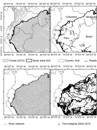
The study area (Fig. 1) corresponded to the north-western (80–65◦W, 10◦S–6◦N) part of Amazonia shared by Colom-bia, Ecuador, Peru, Venezuela and Brazil. The most northerly and westerly limits were delimited using a biogeographic limit corresponding to the South American tropical and subtropical humid forest biome (UNEP, 2009). The total study area contained approximately 2 140 936 km2 of land of which 582 612 km2 are located north of the Equator and 1 558 324 km2 to the south. The largest area belonged to Brazil (41 % or 885 459 km2), followed by Peru (26 %, 559 709 km2)and Colombia (21 % or 451 847 km2)and fi-nally Venezuela and Ecuador with a 8 % (173 966 km2)and 3 % respectively (69 955 km2).
2.2 Data sources and analyses We used the following data sources:
– A forest/non-forest map for 2010 derived from the 25 m global PALSAR mosaics produced using JAXA data from Advanced Land Observing Satellite (ALOS)/Phased Array type L-band SAR (PALSAR), Japan Aerospace Exploration Agency. Accuracy was over 84.86 % with regional variations (Shimada et al., 2014).
Re-Figure 1.Location of the study area, roads and river network and fire hotspots detected for the period 2003–2015 and a portion of the territory shared amongst countries.
source Management System: Archiving and Distribut-ing MODIS Active Fire Data, Collection 6). We only used data with confidence levels over 30 % (nominal and high confidence fires as applied in (Armenteras et al., 2016; Chen et al., 2013a) We standardized fire oc-currence by the area in km2of the unit of analysis, so we used fire density (number of occurrences per 1000 km2)
as a fire variable.
– Roads from CIESIN-ITOS (Center for International Earth Science Information Network, 2013). This data set is the best publicly available information up to 2010 for the region. The database was built from public
do-main road data and has some topology corrected at the national level. The roads are joined topologically at the country borders. The approximate scale is 1:250 000. This database shows no roads for Venezuela in the Ama-zonia; therefore, we removed Venezuela from the anal-ysis of accessibility by roads.
[image:3.612.131.469.59.512.2]Shuttle Radar Topography Mission (SRTM) (Lehner et al., 2008).
– To examine the temporal patterns of fire occurrence, we first explored the long-term patterns of fire (Jan-uary 2003 to Jan(Jan-uary 2015) to describe both intra-annual and interintra-annual variability. We tested for differ-ences in fire occurrence between those occurring north and south of the Equator using a paired two sample
t test. We also used an ANOVA test to check for dif-ferences in fire occurrence between latitudinal position and another ANOVA test to evaluate the differences be-tween countries.
We explored the effect of accessibility on fire occurrence by analysing the proximity of detected fires to rivers and roads. We calculated the distance of each fire hotspot (the point coordinates were the centre of the 1 km pixel) to the closest river and road. We followed the approach presented by Kumar et al. (2014) and built cumulative frequency dis-tributions (CFDs) per country for each set of distances to quantify the annual probability of the occurrence of fire within a given distance of each transportation means. Ku-mar et al. (2014) built a grid spacing of 0.5 km as reference. To evaluate the observed distributions of distances to road or river networks we followed the procedure layout by Ku-mar et al. (2014). A regularly spaced 1×1 km square grid was created across the study area, including Colombia, Peru, Ecuador, Venezuela and Brazil. Next, distances from all lo-cations in this grid to the road or river networks were calcu-lated. These distance distributions represented our null mod-els (i.e. the distance distributions that would result if there was no association between fires and those networks) against which observations should be compared. Finally, we applied a non-parametric Kolmogorov–Smirnov test to check for dif-ferences between the CFD of the observed distances and that of the corresponding null model on a per-country level. The two-sample Kolmogorov–Smirnov statistics (hereafter, D-statistics) measure the maximum distance between the two CFD curves being compared. The D-statistics index can vary from zero (both CFD curves show a complete overlap; i.e. they match exactly) to one (the two CFD curves do not over-lap).
[image:4.612.306.545.66.382.2]In order to establish a measure of forest fragmentation and to determine whether there were any differences between countries regarding the edge effect on fire occurrence (i.e. fires occurring more frequently near the forest edge), we cal-culated the distance of fires (i.e. pixel centre) to the forest edge (considered as the pixel edge), taking into account dis-tances both towards the interior and the exterior of the forest). We used the 2010 forest map to establish the forest edge. Similarly to the tests for accessibility to roads and rivers, we built CFD curves for the edge distances and compared them (k-sample Anderson–Darling test) both with their respective null models of distances to edges and between countries.
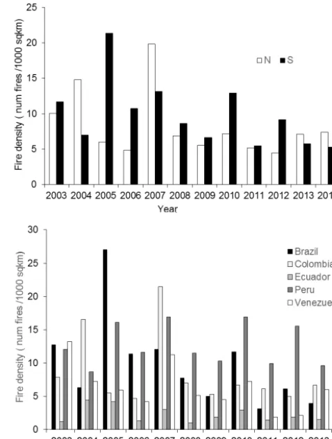
Figure 2. Interannual variability of satellite-detected active-fire density (number/1000 sq km) per latitudinal position (north, south) (a)and country(b).
3 Results
There was high interannual variability of MODIS active fire detections (Fig. 2a). The year with the highest density of fires in the north was 2007 while 2005 was the year with the high-est number of fires in the south. Concerning the years with fewer fires detected, the north had fewer in 2012 while the south showed the lowest number of fires in 2011. Despite the different patterns in terms of annual average fires there was no significant difference (ttest=1.0,p=0.17) between the average annual density to the north (mean×standard de-viation: 7.5×4.6 fires/1000 km2) and to the south of the Equator (9.0×4.8 fires/1000 km2). However annual fire den-sity was significantly different between countries (Fig. 2b, ANOVAF=8.0,p<0.01).
Figure 3. Monthly average satellite-detected active-fire density (number/1000 sq km) per latitudinal position (north, south)(a)and country(b).
the highest proportion of their territory in the north. Brazil (3.9 fires/1000 km2)and Peru, which are mostly located to the south of the Equator had their fire peak in September (4.0 fires/1000 km2). Ecuador, despite having most of its ter-ritory in the Southern Hemisphere had two peaks in January (0.37 fires/1000 km2) and October (0.38 fires/1000 km2). The results of the Kolmogorov–Smirnov tests (Supple-ment 1) used to compare the CFDs of the active fires tances to transportation networks and the null model for dis-tance of the territory within each country, the higher the val-ues the higher the differences between those. For all coun-tries and both roads and rivers, the pattern of fire occurrence is significantly different to their null model and, thus, for each case the fire pattern was related to both roads and rivers (Supplement 1).
Fig. 4 shows the comparison between the CFDs of the observed distributions of distances from fires to the closest rivers (Fig. 4a) and roads (Fig. 4b). There are significant differences between distributions of distances from fires to rivers (Fig. 4a; k-sample Anderson–Darling test, p<0.001) and also to roads (Fig. 4b,k-sample Anderson–Darling test,
p<0.001). A comparison between Fig. 4a and b with their
corresponding null-model curves in Fig. 4c and d indicates that most fires were much closer to the river and the road
networks than a null model would suggest. In addition to thek-sample Anderson–Darling tests, we computed pairwise comparisons between curves within each of the two sets of CFD in order to evaluate the magnitude of their differences. The results are shown in Tables S4 and S5 of Supplement 2, corresponding to comparisons between curves in Fig. 4a and c, and indicate that differences went from 0.01 to 0.39 (aver-age value of 0.2) for distances from fires to rivers (Figs. 4a and Table B1) and from 0.09 to 0.3 (average value of 0.21) for distances from rivers to roads (Fig. 4b and Table S3).
Figure 4a shows that 80 % of fires in Ecuador were within 300 m of the closest rivers, whereas for Colombia this figure increased to 500 m and remained nevertheless below 1 km for the other countries. Figure 4b, in addition, indicates that a large proportion of distances from fires to roads was be-low 10 km for all countries. In turn, a comparison between Fig. 4c and d also shows that null models for rivers and roads behaved differently. The CFDs of the null model for rivers (Fig. 4c) showed a strikingly similar set of curves for all five countries, suggesting that distances from fires to rivers were similarly distributed regardless of the country. Although a
k-sample Anderson–Darling test of that data sets in Fig. 4c yielded a significantp<0.001, the magnitude of the pairwise differences between null-model curves in Fig. 4c was very small (0.01–0.08, average value of 0.039; see Table S3, Sup-plement 2) compared to the differences in Fig. 4a (Table S4), corroborating their apparent similarity. That is, although the
pvalue indicates that the effect (i.e. the difference between curves) exists, the magnitude of that difference in this case is very small (Sullivan and Feinn, 2012). On the other hand, a visual inspection of the distribution of null-model distances from fires to the closest roads (Fig. 4d) showed noticeable differences between countries, a fact that was confirmed by ak-sample Anderson–Darling test (p<0.001) and by the rel-atively large magnitude of the pairwise differences between null-model CFD curves (0.15–0.48, average value of 0.3; see Table S5). A final examination of the curves in Fig. 4d points out that the country with the highest road density (null-model locations closest to roads) in Amazonia was Ecuador, fol-lowed by Peru, Colombia and Brazil.
50 100 200 500 1000 2000 5000
0.0
0.2
0.4
0.6
0.8
1.0
Distance (m)
CFD
BRA COL ECU PER VEN
1e+02 5e+02 5e+03 5e+04 5e+05
0.0
0.2
0.4
0.6
0.8
1.0
Distance (m)
CFD
BRA COL ECU PER
50 100 200 500 1000 2000 5000
0.0
0.2
0.4
0.6
0.8
1.0
Distance (m)
CFD
BRA COL ECU PER VEN
1e+02 5e+02 5e+03 5e+04 5e+05
0.0
0.2
0.4
0.6
0.8
1.0
Distance (m)
CFD
BRA COL ECU PER
(a) (b)
[image:6.612.85.512.65.462.2](c) (d)
Figure 4.Cumulative frequency of the observed closest distance of fires to rivers(a)and roads(b)for each country and of the null model for distances to rivers(c)and roads(d)for each country.
4 Discussion
Our results indicate the temporal pattern of fire occurrence in NW Amazonian tropical forests was determined by its latitu-dinal position (north/south) and by the country. Thus, intense fires seasons in the Northern Hemisphere were almost the op-posite to what is expected in Southern Hemisphere Amazonia in terms of temporal variability (see Fig. 2). Fire dynamics is strongly influenced by climate, and indeed the dry season (∼July–September) in the southern Amazonia corresponded to a wet season in northern Amazonia, and this is well estab-lished. For example, 2004/2005, 2006/2007 and 2009/2010 were El Niño years, affecting the dry season in the Northern Hemisphere, while increased Atlantic sea surface tempera-tures (SST) in the Atlantic Ocean were responsible for the 2005 and 2010 droughts during the dry season in the South-ern Hemisphere (Phillips et al., 2009; Saatchi et al., 2013).
The Atlantic Multidecadal Oscillation (AMO), for instance in 2004, 2005, 2007 and 2010, also influenced fire patterns, with strongly positive effects north of the Equator (Chen et al., 2011). Despite the intra-annual variability, the interan-nual comparison through the average aninteran-nual fire density for the time period studied did not differ significantly between the north and south. This indicated that regions north and south of the Equator may differ as to when fire occurs but they do not show differences in the intensity and land af-fected, as the two hemispheres have been equally affected by fire.
posi-20 50 100 200 500 1000 2000 5000 10000
0.0
0.2
0.4
0.6
0.8
1.0
Distance (m)
CDF
BRA COL ECU PER VEN
20 50 100 200 500 1000 2000 5000 10000
0.0
0.2
0.4
0.6
0.8
1.0
Distance (m)
CFD
BRA COL ECU PER VEN
[image:7.612.70.523.69.276.2](a) (b)
Figure 5.Cumulative frequency of the observed closest distance of fires to the forest edge occurring outside(a)and inside the forest(b)in 2010 for each country.
tive correlation in 2004, 2007 and 2010 (Chen et al., 2011). Colombia had higher fire density in 2004 and 2007 dur-ing two dry seasons associated with El Niño (Armenteras-Pascual et al., 2011) and also influenced by the AMO (Chen et al., 2013b). For Ecuador, only 2004 and 2005 stood out as relative higher density years for this country and are likely as-sociated with the AMO in 2004 and the SST-asas-sociated 2005 drought. Venezuela, the only country in this study with all its territory in the Northern Hemisphere, presented a high den-sity of fires in 2004 in association with AMO (Chen et al., 2011) and in the 2007 El Niño year following the same pat-tern as Colombia. Finally, in 2005 and 2010 Peru presented high densities of fires as expected, being in the Southern Hemisphere. However, Peru stood out in 2007 (a year with particularly more fires in the Northern Hemisphere) for ex-cessive fire density and showed another peak in 2012. The first peak could be associated with the AMO and the 2012 peak with the SST or La Niña year (Marengo et al., 2013), but this also might indicate that, apart from climate, there are other factors influencing the occurrence of fire in this coun-try.
Regarding the influence of accessibility on fire occurrence, we also found (as obtained in a recent study in Legal Amazo-nia, Kumar et al., 2014) that fires were associated with roads, most of them within 10 km but with a lower 75 % of the 90 % found in Legal Amazonia. This was likely due to the unavail-ability of data on unmapped and newly developed roads. Un-like the Legal Amazonia study, we did not look at the official and unmapped/unofficial roads because this information is not available yet and nor is the year by year road develop-ment for most NW Amazonian countries. However, contrary to Kumar et al. (2014), we found that fires are also strongly
associated with rivers, in particular for Colombia, Venezuela and Peru, where most fires occur within 1 km of the clos-est river. The fact that we also obtained this result in Brazil, where Kumar et al. (2014) did not find this association be-tween fires and rivers, is probably due to the fact that they only accounted for navigable rivers. Our study considered the whole river network given the fact that many colonist in the frontier use small boats to access resources in the forest.
Our results revealed differing relationships between roads, fragmentation and deforestation between countries. The opening of roads in Ecuador and Peru, related to the oil in-dustry (Espinosa et al., 2014; Finer et al., 2015; Finer and Jenkins, 2012; Finer and Orta-Martínez, 2010; Mäki et al., 2001), might be an explanation for increased fire occurrence and deforestation in these two countries. The subregions in which some of these developments have occurred have also reported the highest forest loss, particularly in 2009 and 2010 (Potapov et al., 2014). Colombia contains a large area of the undeveloped Amazon and fire is used as a tool to open the colonization frontier. Fire is also used as a pasture manage-ment tool once the frontier advances and basic road infras-tructures are developed (Armenteras et al., 2013b; Dávalos et al., 2014). In Venezuela, although not included in the study due to the poor-quality road data, detected fires most likely resulted from expansion of the agricultural frontier (Pacheco et al., 2014).
to forest fragmentation. The distance to which fire edge ef-fects were detected in our study (within 2 km of forest in-terior edge) coincided with previously recorded distances of fire influence of at least 2–3 km in other areas of Amazonia (Armenteras et al., 2013a; Cochrane and Laurance, 2002) or with the 1–2.7 km at which edge desiccating effects pene-trated into fragmented forests (Briant et al., 2010). Our re-sults also aligned with other studies in Brazil and Colom-bia concluding fire frequency increases at the forest edge (Cochrane 2001; Cochrane and Laurance 2002; Armenteras et al., 2013a). Some studies argue that the majority of fires in Brazil are agricultural fires or escaped fires from man-aged pastures (Cano-Crespo et al., 2015). It is likely that the countries with a higher percentage of fires resulting in de-forestation are those countries, such as Colombia, that have most fires closest to the forest edge and less agricultural de-velopment (Armenteras et al., 2013a). Nevertheless, whether a forest fire is an unintended escaped fire or a fire used for forest conversion to another land use, the strong association of fires with both accessibility and fragmentation is an im-portant result worth highlighting for the different countries. Indeed, if burning mostly occurs along forest edges and is also associated with increased access to the forest, all trop-ical forest edges in all countries are becoming increasingly more exposed to further disturbances. As such there might be different levels of impacts and different causes but there are common ecological consequences such as an increased des-iccation affecting forest structure and composition, degrada-tion of these forests, a decrease in living biomass and finally a reduction of their capacity to act as a carbon sink (Balch et al., 2015; Harper et al., 2005).
5 Conclusions
This study showed that, within the same tropical forest biome, there were clear differences between countries in terms of timing of peak fire season (different years, differ-ent peaks per country) and that accessibility was associated with increased fire occurrence. Forest edge effects occurred equally in all countries and it might be worthwhile address-ing them either regionally or for each individual country, since they are causing forest degradation. All our results un-derscored the influence, not only of climate, but likely of the strong socio-economic factors (van der Werf et al., 2004) in increasing fires that drive deforestation. Future manage-ment plans for NW Amazonia should consider the potential and synergistic edge effects derived from infrastructure de-velopment plans and national climate adaptation and miti-gation policies. More frequent fires along increasingly frag-mented forests may also have other undesired cascade effects in terms of forest degradation and emissions. Subsequent for-est loss should be addressed in the context of Reducing Emis-sions from Deforestation and Forest Degradation (REDD) strategies or other policy mechanisms implemented locally.
Data availability. All data is publically available from their
origi-nal sources as stated in the methods section.
The Supplement related to this article is available online at https://doi.org/10.5194/bg-14-2755-2017-supplement.
Author contributions. Dolors Armenteras and Javier Retana
con-ceived the idea, designed the analysis, performed the data anal-ysis and wrote the manuscript; Joan Sebastian Barreto and Roberto Molowny-Horas analysed the data. Karyn Tabor con-tributed to writing part of the manuscript. All authors concon-tributed to revising the manuscript.
Competing interests. The authors declare that they have no conflict
of interest.
Acknowledgements. We thank the Fulbright Program for the
support given to the first author through the NEXUS Scholar Program. We also thank the Universidad Nacional de Colombia for its support to Joan Sebastian Barreto through the Programa Nacional de Iniciación en Investigación, Creación e Innovación de la Universidad Nacional de Colombia 2013–2015 (Código 29122).
Edited by: A. Rammig
Reviewed by: Philip Fearnside, P. M. L. A. Graça and three anonymous referees
References
Adeney, J. M., Christensen, N. L., and Pimm, S. L.: Reserves protect against deforestation fires in the Amazon, PLoS One, 4, e5014, https://doi.org/10.1371/journal.pone.0005014, 2009.
Aragão, L. E. O. C., Malhi, Y., Roman-Cuesta, R. M., Saatchi, S., Anderson, L. O., and Shimabukuro, Y. E.: Spatial patterns and fire response of recent Amazonian droughts, Geophys. Res. Lett., 34, 1–5, https://doi.org/10.1029/2006GL028946, 2007. Aragão, L. E. O. C, Malhi, Y., Barbier, N., Lima, A., Shimabukuro,
Y., Anderson, L., and Saatchi, S.: Interactions between rain-fall, deforestation and fires during recent years in the Brazil-ian Amazonia, Philos. Trans. R. Soc. B, 363, 1779–1785, https://doi.org/10.1098/rstb.2007.0026, 2008.
Armenteras, D. and Retana, J.: Dynamics, patterns and causes of fires in Northwestern Amazonia, edited by: Bond-Lamberty, B., PLoS One, 7, e35288, https://doi.org/10.1371/journal.pone.0035288, 2012.
Armenteras, D., González, T. M., and Retana, J.: Forest fragmen-tation and edge influence on fire occurrence and intensity un-der different management types in Amazon forests, Biol. Con-serv., 159, 73–79, https://doi.org/10.1016/j.biocon.2012.10.026, 2013a.
Defor-estation, edited by: Fuller, D. Q., PLoS One, 8, e54310, https://doi.org/10.1371/journal.pone.0054310, 2013b.
Armenteras, D., Gibbes, C., Vivacqua, C., Espinosa, J., Duleba, W., Goncalves, F., and Castro, C.: Interactions between Climate, Land Use and Vegetation Fire Occurrences in El Salvador, Atmo-sphere (Basel), 7, 1–14, https://doi.org/10.3390/atmos7020026, 2016.
Armenteras-Pascual, D., Retana-Alumbreros, J., Molowny-Horas, R., Roman-Cuesta, R. M., Gonzalez-Alonso, F., and Morales-Rivas, M.: Characterising fire spatial pattern interactions with climate and vegetation in Colombia, Agric. For. Meteorol., 151, 279–289, https://doi.org/10.1016/j.agrformet.2010.11.002, 2011.
Asner, G. P. and Alencar, A.: Drought impacts on the Amazon for-est: the remote sensing perspective, New Phytol., 187, 569–578, https://doi.org/10.1111/j.1469-8137.2010.03310.x, 2010. Balch, J. K., Brando, P. M., Nepstad, D. C., Coe, M. T., Silvério, D.,
Massad, T. J., Davidson, E. A., Lefebvre, P., Oliveira-Santos, C., Rocha, W., Cury, R. T. S., Parsons, A., and Carvalho, K. S.: The Susceptibility of Southeastern Amazon Forests to Fire: Insights from a Large-Scale Burn Experiment, Bioscience, 65, 893–905, https://doi.org/10.1093/biosci/biv106, 2015.
Barber, C. P., Cochrane, M. A., Souza, C. M., and Laurance, W. F.: Roads, deforestation, and the mitigating effect of pro-tected areas in the Amazon, Biol. Conserv., 177, 203–209, https://doi.org/10.1016/j.biocon.2014.07.004, 2014.
Barlow, J. and Peres, C. A.: Ecological responses to el Niño-induced surface fires in central Brazilian Amazonia: management im-plications for flammable tropical forests, Philos. Trans. R. Soc. Lond. B., 359, 367–380, https://doi.org/10.1098/rstb.2003.1423, 2004.
Bowman, D. M. J. S., Balch, J. K., Artaxo, P., Bond, W. J., Carl-son, J. M., Cochrane, M. A., D’Antonio, C. M., Defries, R. S., Doyle, J. C., Harrison, S. P., Johnston, F. H., Keeley, J. E., Krawchuk, M. A., Kull, C. A., Marston, J. B., Moritz, M. A., Prentice, I. C., Roos, C. I., Scott, A. C., Swetnam, T. W., van der Werf, G. R., Pyne, S. J., Antonio, C. M. D., and Werf, G. R. Van Der: Fire in the Earth System, Science, 324, 481–484, https://doi.org/10.1126/science.1163886, 2009.
Brando, P. M., Coe, M. T., DeFries, R., and Azevedo, A. A.: Ecology, economy and management of an agroindustrial frontier landscape in the southeast Amazon., Philos. Trans. R. Soc. Lond. B., 368, 20120152, https://doi.org/10.1098/rstb.2012.0152, 2013.
Briant, G., Gond, V., and Laurance, S. G. W.: Habitat frag-mentation and the desiccation of forest canopies: A case study from eastern Amazonia, Biol. Conserv., 143, 2763–2769, https://doi.org/10.1016/j.biocon.2010.07.024, 2010.
Brown, I. F., Schroeder, W., Setzer, A., De Los Rios Maldonado, M., Pantoja, N., Duarte, A., and Marengo, J.: Monitoring fires in southwestern Amazonia Rain Forests, Eos, Trans. Am. Geophys. Union, 87, 253–259, https://doi.org/10.1029/2006EO260001, 2006.
Cano-Crespo, A., Oliveira, P. J. C., Boit, A., Cardoso, M., and Thonicke, K.: Forest edge burning in the Brazil-ian Amazon promoted by escaping fires from managed pastures, J. Geophys. Res.-Biogeo., 120, 2095–2107, https://doi.org/10.1002/2015JG002914, 2015.
Center for International Earth Science Information Network: CIESIN, Columbia and Information Technology Outreach Ser-vices, ITOS, University of Georgia: Global Roads Open Access Data Set, Version 1 (gROADSv1), NASA Socioecon. Data Appl. Cent., https://doi.org/10.7927/H4VD6WCT, 2013.
Chen, Y., Randerson, J. T., Morton, D. C., DeFries, R. S., Col-latz, G. J., Kasibhatla, P. S., Giglio, L., Jin, Y., and Marlier, M. E.: Forecasting Fire Season Severity in South America Us-ing Sea Surface Temperature Anomalies, Science, 334, 787–791, https://doi.org/10.1126/science.1209472, 2011.
Chen, Y., Morton, D. C., Jin, Y., Collatz, G. J., Kasibhatla, P. S., van der Werf, G. R., DeFries, R. S., and Randerson, J. T.: Long-term trends and interannual variability of forest, savanna and agricultural fires in South America, Carbon Manag., 4, 617–638, https://doi.org/10.4155/cmt.13.61, 2013a.
Chen, Y., Velicogna, I., Famiglietti, J. S., and Randerson, J. T.: Satellite observations of terrestrial water storage provide early warning information about drought and fire season sever-ity in the Amazon, J. Geophys. Res.-Biogeo., 118, 495–504, https://doi.org/10.1002/jgrg.20046, 2013b.
Chuvieco, E., Opazo, S., Sione, W., Del Valle, H., Anaya, J. A., Di Bella, C., Cruz, I., Manzo, L., Lopez, G., Mari, N., González-Alonso, F., Morelli, F., Setzer, A., Csiszar, I., Kanpandegi, J. A., Bastarrika, A., and Libonati, R.: Global burned-land estimation in Latin America using MODIS composite data, Ecol. Appl., 18, 64–79, https://doi.org/10.1890/06-2148.1, 2008.
Cochrane, M.: Tropical fire ecology: climate change, land use and ecosystem dynamics, Series Spr., Springer, 2009.
Cochrane, M. A.: Synergistic Interactions between Habitat Frag-mentation and Fire in Evergreen Tropical Forests, Conserv. Biol., 15, 1515–1521, 2001.
Cochrane, M. A.: Fire science for rainforests, Nature, 421, 913–918, 2003.
Cochrane, M. A. and Barber, C. P.: Climate change, human land use and future fires in the Amazon, Glob. Change Biol., 15, 601–612, https://doi.org/10.1111/j.1365-2486.2008.01786.x, 2009. Cochrane, M. A. and Laurance, W. F.: Fire as a large-scale
edge effect in Amazonian forests, J. Trop. Ecol., 18, 311–325, https://doi.org/10.1017/S0266467402002237, 2002.
Cochrane, M. A. and Schulze, M. D.: Fire as a Recurrent Event in Tropical Forests of the Eastern Amazon?: Effects on Forest Structure, Biomass, and Species Composition, Biotropica, 31, 2– 16, 1999.
Dávalos, L. M., Holmes, J. S., Rodríguez, N., and Ar-menteras, D.: Demand for beef is unrelated to pasture expan-sion in northwestern Amazonia, Biol. Conserv., 170, 64–73, https://doi.org/10.1016/j.biocon.2013.12.018, 2014.
Espinosa, S., Branch, L. C., and Cueva, R.: Road development and the geography of hunting by an amazonian indigenous group: Consequences for wildlife conservation, PLoS One, 9, 1–21, https://doi.org/10.1371/journal.pone.0114916, 2014.
Fearnside, P. M., Righi, C. A., Graça, P. M. L. D. A., Keizer, E. W. H., Cerri, C. C., Nogueira, E. M., and Barbosa, R. I.: Biomass and greenhouse-gas emissions from land-use change in Brazil’s Amazonian “arc of deforestation”: The states of Mato Grosso and Rondônia, For. Ecol. Manage., 258, 1968–1978, https://doi.org/10.1016/j.foreco.2009.07.042, 2009.
Andes-Amazon connectivity, PLoS One, 7, e35126, https://doi.org/10.1371/journal.pone.0035126, 2012.
Finer, M. and Orta-Martínez, M.: A second hydrocarbon boom threatens the Peruvian Amazon: trends, projections, and policy implications, Environ. Res. Lett., 5, 14012, https://doi.org/10.1088/1748-9326/5/1/014012, 2010.
Finer, M., Babbitt, B., Novoa, S., Ferrarese, F., Pappalardo, S. E., Marchi, M. De, Saucedo, M., and Kumar, A.: Future of oil and gas development in the western Amazon, Environ. Res. Lett., 10, 1–6, https://doi.org/10.1088/1748-9326/10/2/024003, 2015. Flannigan, M. D., Krawchuk, M. A., de Groot, W. J., Wotton,
B. M., and Gowman, L. M.: Implications of changing cli-mate for global wildland fire, Int. J. Wildl. Fire, 18, 483–507, https://doi.org/10.1071/WF08187, 2009.
Harper, K. A., Macdonald, S. E., Burton, P. J., Jiquan, C., Brosofske, K. D., Saunders, S. C., Euskirchen, E. S., Roberts, D. A. R., Jaiteh, M. S., and Esseen, P.: Edge Influence on Forest Structure and Composition in Fragmented Landscapes, Conserv. Biol., 19, 768–782, 2005.
Kauffman, J. B. and Uhl, C.: Interactions of Anthropogenic Ac-tivities, Fire, and Rain Forests in the Amazon Basin, in Fire in the Tropical Biota, edited by: Goldammer, J. G., Springer Berlin Heidelberg, Berlin, Heidelberg, 84, 117–134, 1990.
Kinnaird, M. F. and O’Brien, T. G.: Ecological Effects of Wildfire on Lowland Rainforest in Sumatra, Conserv. Biol., 12, 954–956, https://doi.org/10.1046/j.1523-1739.1998.012005954.x, 1998. Kirby, K. R., Laurance, W. F., Albernaz, A. K., Schroth, G.,
Fearn-side, P. M., Bergen, S., Venticinque, E. M., and da Costa, C.: The future of deforestation in the Brazilian Amazon, Futures, 38, 432–453, https://doi.org/10.1016/j.futures.2005.07.011, 2006. Kumar, S. S., Roy, D. P., Cochrane, M. A., Souza, C. M., Barber,
C. P., and Boschetti, L.: A quantitative study of the proximity of satellite detected active fires to roads and rivers in the Brazil-ian tropical moist forest biome, Int. J. Wildl. Fire, 23, 532–543, https://doi.org/10.1071/WF13106, 2014.
Laurance, W. F., Albernaz, A. K. M., Schroth, G., Fearnside, P. M., Bergen, S., Venticinque, E. M., and Da Costa, C.: Predictors of deforestation in the Brazilian Amazon, J. Biogeogr., 29, 737– 748, https://doi.org/10.1046/j.1365-2699.2002.00721.x, 2002. Lehner, B., Verdin, K., and Jarvis, A.: New global
hydrogra-phy derived from spaceborne elevation data, Eos, 89, 93–94, https://doi.org/10.1029/2008EO100001, 2008.
Lewis, S. L., Brando, P. M., Phillips, O. L., van der Heijden, G. M. F., and Nepstad, D.: The 2010 Amazon drought, Science, 331, 554, https://doi.org/10.1126/science.1200807, 2011.
Lima, A., Silva, T. S. F., de Aragão, L. E. O. e C., de Feitas, R. M., Adami, M., Formaggio, A. R., and Shimabukuro, Y. E.: Land use and land cover changes determine the spatial relationship be-tween fire and deforestation in the Brazilian Amazon, Appl. Ge-ogr., 34, 239–246, https://doi.org/10.1016/j.apgeog.2011.10.013, 2012.
Mäki, S., Kalliola, R., and Vuorinen, K. A. I.: Road construction in the Peruvian Amazon?: process , causes and consequences, Environ. Conserv., 28, 199–214, 2001.
Malhi, Y. and Wright, J.: Spatial patterns and recent trends in the cli-mate of tropical rainforest regions., Philos. Trans. R. Soc. Lond. B, 359, 311–329, https://doi.org/10.1098/rstb.2003.1433, 2004. Malhi, Y., Roberts, J. T., Betts, R. A., Killeen, T. J.,
Li, W., and Nobre, C. A.: Climate change,
deforesta-tion, and the fate of the Amazon, Science, 319, 169–172, https://doi.org/10.1126/science.1146961, 2008.
Malhi, Y., Aragão, L. E. O. C., Galbraith, D., Hunting-ford, C., Fisher, R., Zelazowski, P., Sitch, S., McSweeney, C., and Meir, P.: Exploring the likelihood and mecha-nism of a climate-change-induced dieback of the Amazon rainforest, P. Natl. Acad. Sci. USA, 106, 20610–20615, https://doi.org/10.1073/pnas.0804619106, 2009.
Marengo, J. A.: Interannual variability of surface climate in the Amazon basin, Int. J. Climatol., 12, 853–863, https://doi.org/10.1002/joc.3370120808, 1992.
Marengo, J. A. and Tomasella, J.: Trends in streamflow and rainfall in tropical South America: Amazonia, eastern Brazil, and north-western Peru, J. Geophys. Res., 103, 1775–1783, 1998. Marengo, J., Nobre, C. A., Tomasella, J., Oyama, M. D., de
Oliveira, G. S., de Oliveira, R., Camargo, H., Alves, L. M., and Brown, I. F.: The drought of Amazonia in 2005, J. Clim., 21, 495–516, https://doi.org/10.1175/2007JCLI1600.1, 2008a. Marengo, J. A., Nobre, C. A., Tomasella, J., Cardoso, M. F., and
Oyama, M. D.: Hydro-climate and ecological behaviour of the drought of Amazonia in 2005., Philos. Trans. R. Soc. Lond. B, 363, 1773–1778, https://doi.org/10.1098/rstb.2007.0015, 2008b. Marengo, J. A., Alves, L. M., Soares, W. R., Rodriguez, D. A., Camargo, H., Riveros, M. P., and Diaz-Pabló, A.: Two contrast-ing severe seasonal extremes in tropical South America in 2012: Flood in Amazonia and drought in Northeast Brazil, J. Clim., 26, 9137–9154, https://doi.org/10.1175/JCLI-D-12-00642.1, 2013. Morton, D. C., Shimabukuro, Y. E., Rudorff, B. F. T., Freitas, R.
M., and Defries, R. S.: Conservation challenge at the agricultural frontier?: deforestation , fire , and land use dynamics in Mato Grosso Desafios para conservação nas áreas de fronteiras agríco-las?: desflorestamento , fogo e dinâmica do uso da terra no Mato Grosso, Rev. Ambient. e Agua, 2, 5–20, 2007.
Nepstad, D., Carvalho, G., Cristina, A., Alencar, A., Paulo, Ä., Bishop, J., Moutinho, P., Lefebvre, P., Lopes Silva Jr., U., and Prins, E.: Road paving, fire regime feedbacks, and the future of Amazon forests, For. Ecol. Manage., 154, 395–407, 2001. Pacheco, C. E., Aguado, M. I., and Mollicone, D.: Identification
and characterization of deforestation hot spots in Venezuela using MODIS satellite images, Acta Amaz., 44, 185–196, https://doi.org/10.1590/S0044-59672014000200004, 2014. Phillips, O. L., Aragão, L. E. O. C., Lewis, S. L., Fisher, J. B.,
Potapov, P. V, Dempewolf, J., Talero, Y., Hansen, M. C., Stehman, S. V, Vargas, C., Rojas, E. J., Castillo, D., Mendoza, E., Calderón, A., Giudice, R., Malaga, N., and Zutta, B. R.: National satellite-based humid tropical forest change assessment in Peru in sup-port of REDD+implementation, Environ. Res. Lett., 9, 124012, https://doi.org/10.1088/1748-9326/9/12/124012, 2014.
Ray, D., Nepstad, D., and Moutinho, P.: Micrometeorological and canopy controls of fire susceptibility in a forested amazon land-scape, Ecol. Appl., 15, 1664–1678, https://doi.org/10.1890/05-0404, 2005.
Roy, D. P. and Kumar, S. S.: Multi-year MODIS ac-tive fire type classification over the Brazilian Tropi-cal Moist Forest Biome, Int. J. Digit. Earth, 10, 1–31, https://doi.org/10.1080/17538947.2016.1208686, 2017. Saatchi, S., Asefi-Najafabady, S., Malhi, Y., Aragão, L. E.
O. C., Anderson, L. O., Myneni, R. B., and Nemani, R.: Persistent effects of a severe drought on Amazonian forest canopy, P. Natl. Acad. Sci. USA, 110, 565–70, https://doi.org/10.1073/pnas.1204651110, 2013.
Salati, E.: The forest and the hydrological cycle, in: The Geophysi-ology of Amazonia. Vegetation and Climate Interactions, edited by: Dickinson, R. E., John Wiley & Sons, New York, 273–296, 1987.
Salati, E. and Vose, P. B.: Amazon basin: a sys-tem in equilibrium, Science, 225, 129–138, https://doi.org/10.1126/science.225.4658.129, 1984.
Shimada, M., Itoh, T., Motooka, T., Watanabe, M., Shiraishi, T., Thapa, R., and Lucas, R.: New global forest/non-forest maps from ALOS PALSAR data (2007–2010), Remote Sens. Environ., 155, 13–31, https://doi.org/10.1016/j.rse.2014.04.014, 2014. Sullivan, G. M. and Feinn, R.: Using Effect Size-or Why the P Value
Is Not Enough, Journal of Graduate Medical Education, 4, 279– 82, https://doi.org/10.4300/JGME-D-12-00156.1, 2012. UNEP: GeoAmazonia, edited by: UNEP, available from: United,
http://www.pnuma.org/deat1/pdf/GEOAMAZONIA_english_ 10FEB.pdf (last access: December 2015), 2009.