© 2015, IRJET ISO 9001:2008 Certified Journal
Page 2384
A Novel Technique for Enhancing the Localization Accuracy of
(VANET) Vehicles Using GPS , INS and RBFNN
Sunita S. Shinde
1, Ravi M. Yadahalli
21 Assistant Professor, Department of Electronics and Telecommunication Engineering, A.D.C.E.T., Ashta(Sangli),
Maharashtra, India
2 Professor & Dean(Examinations), Department of Electronics & Communication Engineering, S.G.B.I.T., Belgaum,
Karnataka, India
---***---
Abstract -
The demand for seamless positioning hasbeen significantly high in vehicular applications, such as navigation, intelligent transportation systems, collision avoidance, etc. Most seamless positioning techniques are based on integrated methods. the inertial navigation system (INS) and the global positioning system (GPS) are two complementary technologies that can be integrated to provide reliable positioning and navigation information for vehicles. The accuracy enhancement of INS and the integration of INS with GPS are the subjects of widespread research. This paper presents a novel GPS-INS integrated approach to enhance the localization accuracy of VANET vehicles using RBFNN. The performance of the proposed localization system is evaluated using MatLab.
Key Words:
Vehicular, localization, GPS, INS, RBFNN ,
etc…
1. INTRODUCTION
The demand for seamless positioning has significantly increased since the introduction of 'ubiquitous computing' in the late 1980. Vehicle's localization[1] is a key issue that has recently attracted attention in the wide range of application. GPS technology [2, 3] provides good localization accuracy when vehicle is traveling in open environment, but during long GPS outage (multipath environment) INS, RFID technologies plays an important role to provide localization accuracy.
This paper introduces an integrated technology of GPS and INS based on Kalman Filter & RBFNN which provides better localization accuracy. This Paper is organized as follows. Next section shows implementation of GPS-INS integrated scenario. Kalman Filter and result are discussed in detail in section III. Section IV gives the details of
advance localization technique with results. Section V provides our conclusion.
2. DEFAULT SCENARIO FOR PROPOSED SYSTEM
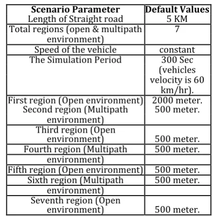
[image:1.595.321.540.358.580.2]For the implementation of the proposed system default scenario is considered and the values of the default parameters are shown in the Table 1.
Table -1: Scenario Parameters with default values
Scenario Parameter Default Values
Length of Straight road 5 KM
Total regions (open & multipath 7 environment)
Speed of the vehicle constant
The Simulation Period 300 Sec
(vehicles velocity is 60
km/hr). First region (Open environment) 2000 meter.
Second region (Multipath 500 meter.
environment) Third region (Open
environment) 500 meter.
Fourth region (Multipath 500 meter.
environment)
Fifth region (Open environment) 500 meter.
Sixth region (Multipath 500 meter.
environment) Seventh region (Open
environment) 500 meter.
By using above mentioned default parameters, the implementation of proposed scenario is carried out and the effect of the scenario parameters on accuracy is observed.
© 2015, IRJET ISO 9001:2008 Certified Journal
Page 2385
Fig-1: VANET Vehicle Simulation Scenario consists of fourOpen and three Multipath
3. KALMAN FILTER AND RESULTS
Kalman filter is used to integrate GPS & INS reading[4]. Figure II shows the Kalman Filter estimation of localization of a vehicle travelling over 5 km straight road with constant velocity of 60 km/hr. It shows the effect of multipath environment on Kalman Filter output.
Fig -2:Localization Technique by using Kalman Filter to integrate the GPS receiver measurement and INS measurement in an open as well as multipath environment along straight road.
[image:2.595.307.557.127.335.2]In an open environment region Kalman Filter localization gives minimum variation while it is affected in multipath environment. The coordinates in multipath environments are absolutely different as compared with real paths coordinates while they are closely appearing with real path in an open environment. Next part of experiments is to detect that multipath environment and reduce the variations present in it. The error calculations of Kalman Filter are given in tabular form, in which mean error and standard deviations are calculated by localization error. The random results are given below because is a consideration of random process of localization.
Table - 2: Error calculations for the localization using the GPS & GPS/INS (KF).
Sr. Type of Mean Error(m) SD of Error(m)
No. Environment GPS GPS- GPS GPS-
INS(KF) INS(KF)
1. First Open -0.68 -1.29 12.26 3.34
Environ.
2. First Multipath -8.72 -0.80 94.82 33.23 Environment
3. Second Open -2.60 -4.37 25.90 10.37
Environ.
4. Second 18.84 10.55 97.04 42.64
Multipath Environment
5. Third Open 2.33 4.01 16.15 10.12
Environ.
6. Third -9.37 -5.27 96.11 25.04
Multipath Environment
7. Fourth Open 2.30 0.67 10.22 2.96
Environment
4. PERFORMANCE OF ANN IN DETECTING
MULTIPATH ENVIRONMENT
The performance of ANN is very important to detect multipath environment. A Radial Basis Function Neural Network is used to detect multipath environment since it falls under the supervised learning category of Artificial Neural Networks (ANN)[5, 6]. Inconsistency value is defined for open environment and multipath environment and then simulation is carried out for the RBFNN network.
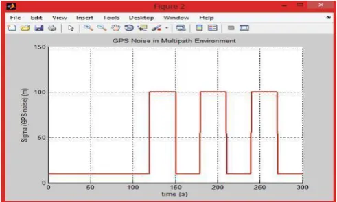
4.1 GPS noise with respect to time:
When a vehicle does not experience any multipath effect, the accuracy of the GPS accuracy is good and the inconsistency value be small. However, if a vehicle experiences a multipath effect, the accuracy of the GPS is drastically affected and the inconsistency values be totally and randomly different.
[image:2.595.306.557.128.334.2] [image:2.595.43.261.401.537.2] [image:2.595.310.556.571.718.2]© 2015, IRJET ISO 9001:2008 Certified Journal
Page 2386
4.2 Inconsistency value with respect to time:
The inconsistency value is the difference between time update estimate of KF and GPS receiver measurement.
[image:3.595.309.550.107.256.2]
Fig - 4: Inconsistency value with respect to time.
4.3 RBFNN output before Thresholding:
[image:3.595.42.272.146.294.2]In simulation near about 1.5 value is set as a threshold. Below graph shows output of RBFNN before thresholding in which RBFNN gives the target value 1 and 2 for open and multipath environment respectively.
Fig -5: ANN output before Thresholding
4.4 RBFNN as a Multipath Detector (Classifier):
Basically RBFNN was trained by using inconsistency value randomly generated in open environment and multipath environment in simulation. After thresholding the RBFNN has given the output in the form of 1 and 2 which is shown in fig - 6.Fig -6: The decision of the RBFNN(Classifier):2>=Yes and 1>=No
5. ADVANCE LOCALIZATION TECHNIQUE IN
MULTIPATH ENVIRONMENT WHICH IMPROVES
THE ACCURACY
This advance localization technique is basically depends on least square optimization which minimizes the error in localizing a target vehicle using other vehicles as a reference nodes and those are not or less affected by multipath environment and they are more accurate about their localization.
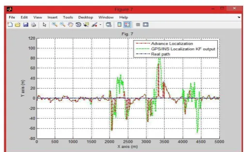
Fig - 7 shows the Localization of a Vehicle by Advance Localization Technique.
Fig -7: Localization of a Vehicle by Advance Localization Technique.
[image:3.595.45.270.403.564.2] [image:3.595.318.570.463.620.2]© 2015, IRJET ISO 9001:2008 Certified Journal
Page 2387
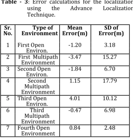
Table - 3: Error calculations for the localizationusing the Advance Localization
Technique.
Sr.
No. Environment Type of Error(m) Mean Error(m) SD of
1 First Open -1.20 3.18
Environ.
2 First Multipath -3.47 15.27
Environment
3 Second Open -1.84 6.70
Environ.
4 Second 1.15 17.79
Multipath Environment
5 Third Open 4.01 10.12
Environ.
6 Third -0.47 6.98
Multipath Environment
7 Fourth Open 0.84 2.48
Environment
5.1 Comparison of Advance Localization with GPS
and GPS/INS(KF)
Table - 4 shows the error calculation for GPS, GPS/INS localization technique and advance localization technique. This shows that the effect of multipath environment is very high for GPS, GPS/INS localization but it minimum in advance localization. The performance of advance localization is very effective during multipath areas i.e. mean and standard deviation errors become very less as compared with mean and standard deviation errors of GPS & GPS/INS localization technique [7, 8, 9].
[image:4.595.54.275.104.335.2]Table - 4 : Comparison of Error calculations for the localization using KF Localization and the Advance Localization Technique.
Fig - 8 and 9 shows a comparison of the three techniques with mean error and standard deviation error respectively. The performances of the techniques are somehow similar in an open environments but drastically changes in multipath environments.
Fig - 8: Comparison of GPS, GPS/INS and Advance Localization: Mean Localization Error Related with Different Environments
Fig - 9 shows the comparison of standard deviations The standard deviation is also similar in an open environment for all techniques but it is different in multipath environments.
Fig - 9: Comparison of GPS, GPS/INS and Advance Localization: Standard Deviation of Error of Localization Error Related with Different Environments.
6. CONCLUSION
[image:4.595.314.546.179.303.2] [image:4.595.321.552.413.556.2]© 2015, IRJET ISO 9001:2008 Certified Journal
Page 2388
REFERENCES
[1] Benslimane A, “Localization in vehicular ad-hoc networks,” Proc. Syst Communication 19-25 DOI: 10.1109/ICW.2005.54,2005.
[2] B.hofmann-wellenho, H.lichtenegger, J.collins, ―Globle Positioning Sytem: Theory & Practices, 4 Ed.,Springer-verlag,1997.
[3] E.D.Caplan, ―Understading GPS: Principles & Applications‖,
Artechouse, 1996
[4] Hajar Barani and Mahmoud Fathy,"An algorithm for Localization in Vehicular AdHoc Networks" 2010 Science Publications, Department of Computer Engineering, Iran University of Science and Technology, Tehran, Iran.
[5] J. Caffery and G Stuber, " Overview of radiolocation in CDMA cellularsystems", IEEE ommunication Mag. Vol. 36, No. 4, PP. 38-45, April 1998
[6] Nabil Mohamed Drawil and Otman Basir,
"Intervehicle-Communication-Assisted Localization", IEEE Transactions on Intelligent Transportation Systems, Vol. 11, No. 3, September 2010.
[7] S. Biswas, R. Tatchikou, F. Dion," Vehicle to vehicle wireless communication protocols for enhancing highway traffic safety", IEEE Communication Magazine 44 (1), PP. 74-82, 2006.
[8] T. Melgard, G. Lachapelle, and H. Gehue, " GPS signal availability in an urban area receiver performance analysis", in Proc. IEEE Position Location Navigation Symp., PP. 487-493, 1994.
[9] Wesel E. K. Wireless Multimedia Communication: Networking Video, Voice and Data. 1st Ed. , Addison Wesley, Massachusetts, Usa, ISBN: 10:0201633949, PP:298, 1997.
BIOGRAPHIES
Mrs. Sunita S. Shinde received the Bachelor’s degree, the Masters degree in Electronics Engineering from from Shivaji University, Kolhapur, Maharashtra She is
having 14 years teaching
experience. Her field of interest is Wireless communication, Adhoc Networks. She is a life member of ISTE or IEEE. She wrote three books on Computer Networks.
Ravi M. Yadahalli received the Bachelor’s degree, the Masters degree, and the Ph.D. degree from the Gulbarga University, Gulbarga, India in 1990, 1993, and 2009, respectively. From 1993 to 2010, he worked in various positions at the SDM College of Engineering and Technology, Dharwad, India. Since 2010, he has been with the Department of Electronics and Communication Engineering, PES Institute of Technology and
Management, where he is
currently Professor and Head of the Department. His research interests cover several aspects of microwave engineering including microwave antennas. He has published over 50 papers in
technical journals and
conferences. He is the reviewer of the Journal of the Electromagnetic Waves and Applications (JEMWA) Progress in Electromagnetic Research (PIER, PIER B, C, M, PIER