KAROLÍNA PAUKNEROVÁ
TWO SETTLEMENT PATTERNS IN THE KOLÍN FLATLAND
– A PHENOMENOLOGICAL ANALYSIS*
Abstract: The fertile flatland of Kolín, a small town east of Prague, belongs among ancient settlement areas. The landscape of Kolín Flatland is limited on the north by the river Elbe (Labe) and in the south by the ridge of hills Kaňk, Grunta, Malý and Velký Kuklík, Miskovický and Opatovický vrch. Today it is an agricultural area scattered with small woods and villages. For the paper, two settle-ment patterns were chosen to be phenomenologically analysed: the Stroked Pottery Culture with the centre in Libenice and the Aunjetitz Culture settlement pattern with the centre in Polepy. In the paper, the author deals with the question of how the people of different times and different cultures behaved in the same terrain and how their settlement strategies varied; in other words, she researches the differences of the two settlement patterns in the same terrain.
Key words: Aunjetitz Culture; Stroked Pottery Culture; landscape; Libenice; phenomenology; Polepy; Settlement strategy.
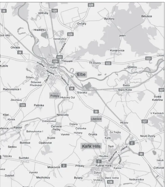
The article deals with the phenomenological research of the settlement strategies of two cultures in the Kolín Flatland. The fertile flatland of Kolín, a small town 65 km east of Prague, belongs among ancient settlement areas (Fig. 1). Two cultures were chosen for the comparison: the Stroked Pottery Culture and the Únětice (Aunjetitz) Culture. As centres for the constructed settlement structure, the most famous localities of these two cultures were selected. These are Libenice and its surroundings for the Stroked Pot-tery Culture and Polepy and its surroundings for the Únětice Culture. This choice was simply arbitrary; other sites could work for the analysis as centres, too. They represented centres only for the people who lived there, for their everyday life and their everyday tasks (Fig. 1).
In Czech literature, it is still common that when landscape is regarded within an archaeological site publication the reader learns about the quality of soil, sometimes description of the vicinity is added and the vegetation cover is reconstructed from
paly-* This text originated within the project called ‘Human dimension of archaeological sites. Phenomenological interpretation of settlement areas’ which was financially supported by the Grant Agency of Charles University in Prague (GAUK), agreement no. 8716/2008.
nological and other analyses. However, other perspectives on landscape of past people can be added using the methods of the anthropological sub-discipline – anthropology of landscape (see Hirsch, O’Hanlon 1995). The physical appearance of the Kolín landscape in the Middle Neolithic and the Early Bronze age can be of course reconstructed on the basis of the combination of archaeological and zoological, pedological and other natural science data. However, should we add to this reconstruction the dimension of a lived space, we must use the methods of anthropology or phenomenology of landscape. Fig. 1. Map of the surveyed area – part of the Kolín Flatland, Czech Republic
As a theoretical concept for the research I chose the definition of landscape as task-scape developed by a social anthropologist Tim Ingold. Tasktask-scape is defined as a socially constructed space of human activities (Ingold 2000); it represents a mental construction based on physical space. In other words, a landscape/taskscape in this sense is a space where different human tasks are/were completed or proceed/proceeded. Some traces of these tasks were preserved as archaeological sources and from these traces I tried to re-construct the taskscapes of the people of the Únětice and Stroked Pottery Cultures in the particular landscape. Only a limited number of activities can be reconstructed this way, but still they can create a dynamic picture encompassing the static image given by only archaeological data. I hope that in this way – by a combination of phenomenological research and archaeological data – we can get closer to the so called lived space of the past people.
A method I used is called phenomenological site catchment analysis; it is a combina-tion of an economic approach regarding the sources (site catchment analysis) and an approach regarding the use of space (Hamilton, Whitehouse 2006).
My research was inspired by the phenomenological research of Christopher Tilley and especially by his first book on this topic –A Phenomenology of Landscape (1994). The central argument of the book is that in Europe the transition from Mesolithic to Neo-lithic communities was experienced as a significant change in the relationship between the landscape and people. In particular, new forms of burials and the advent of monu-ment building marked an appropriation of ancestral powers that were ‘sedimonu-mented’ in the topography and symbolic geography of the land. The book was criticized for Tilley’s reduction of landscape to mythopoeia (e.g. Fleming 1999, 2005). More interesting and methodologically more stimulating critique was offered by Adam T. Smith in his book The political landscape: constellations of authority in early complex polities (2003). Smith criticises Tilley’s books for not taking into account the body and the politics of land-scape. What seems to be forgotten in the analyses in the original book from 1994 is that the body itself bears the marks of social process. As Foucault put it – bodies are split, divided, totalized, and broken down within specific socio-political formations (Foucault 1978, 1979, quoted in Smith 2003, p. 65). Hence the body cannot provide a universal foundation for landscape interpretation because it is highly dependent on particular un-derstandings of subjectivity and of social processes of subjectivization. The other critique concerning the politics of landscapes is that the phenomenology of landscape leaves us with a rather apolitical vision of landscape where the sedimentation of meaning in place tends to preclude an account of the interests that shape the particular contours of land-scapes (Smith 2003, p. 65).
Despite the criticism it stimulated, the original book from 1994 persists to be a great inspiration and is appreciated for helping archaeology to break free from prevailing en-vironmental determinism. Both body and politics were incorporated into the method in later works, especially in the article Mind and body in landscape research (Tilley 2004a), and in the books The Materiality of Stone: Explorations in Landscape Phenomenology
(Tilley 2004b) and Stone Worlds: Narrative and Reflexivity in Landscape(Bender, Hamil-ton, Tilley 2007).
In shortness, phenomenological archaeological research means collecting and process-ing sensual data of landscapes and places and analysprocess-ing them together with the data from archaeological research. Sensual data are simply information of our senses on colour, smell and visuality of the landscape. As a research tool, human body is used and it’s the most ordinary human activity – walking (Fig. 2).
FIELDWORK COURSE
The town of Kolín is situated about 65 km in the eastern direction from Prague, in the place where the river Elbe (Labe) changes its direction in a great arch from the West to the North. The fieldwork took place in summer and autumn 2008 and in February 2009. With my co-workers we concentrated on browsing through the landscape at the southern side limited by the ridge of hills Kaňk, Grunta, Malý and Velký Kuklík, Mis-kovický and Opatovický vrch – which I for shortness call the Kaňk Hills in this paper – and the northern side by the today’s Elbe river-basin. Two-hour walk from Libenice to the East and from Polepy to the West formed the other two limits. The two-hour walk limit represents for me a synonym for the usual maximum distance walked for everyday tasks.
At the beginning I concentrated on the observation of the localities setting in the landscape. And than, so as to (re)construct the taskscape, we walked to the nearest locali-Fig. 2. The Southern view from the Malý Kuklík hill to the Kolín Flatland
ties of the same culture and collected the data. Other tracks headed to possible observa-tory points and along the brooks (Pekelský, Polepka, Nebovidský, Hořanský, Beránka, Stará Klejnárka) towards the Elbe and back. Tracks in the East-West direction and back, alongside the nowadays riverbed of Elbe, were also walked.
We collected the data such as maximum visibility from a locality, passability of the terrain, colours of the landscape, which point attracts attention together with very sub-jective data such as feeling safe or not. We measured time needed to reach possible sources within the vicinity of the given locality or to reach the surrounding localities of the same culture etc.
Usually two people formed the research team and the task was to walk the prepared route, draw into the prepared map visibility from specified points and mark the one and two hour walk limits. Time needed to cross modern obstructions, to draw into the map etc. was not counted into one- and two-hour walk limits. During walking a special protocol was completed where the course of walking was described, and sensual data together with anything else that researchers felt important was put down.
Beforehand I prepared a list of Stroked Pottery culture settlements in the vicinity of Libenice and draw them into the map. The same was done also for Polepy. The sites sur-rounding Libenice (Steklá 1961) are: Církvice (Dvořák 1936), Červené Pečky (Dvořák 1936), Dobešovice (Dvořák 1936), Hlízov (Dvořák 1936), Hořany (Rulf 1983; Rulf-Valentová 1995), Chotouchov (Dvořák 1936), Jakub (Rulf-Valentová 1992), Kolín (several localities; Dvořák 1936; Rulf 1983; Křepelková 1964; Svobodová 1968; Hrala-Vávra 1989; Tvrdík 2003, 2007), Kutná Hora (several localities; Pavlů 1997; Šumberová 1998), Lošánky (Dvořák 1936), Malá Vysoká (Dvořák 1936), Malín-Nové Dvory (Šumberová 2000), Nebovidy (Rulf 1983), Nová Ves I (Rulf 1983), Polepy – quarry (Rulf 1983), Ra-dovesnice I (Rulf 1983; Sedláček 1981), Ratboř (Dvořák 1936), Rohozec (Rulf 1985), Starý Kolín (Dvořák 1936), Štítary (Tvrdík 2003; Rulf 1983; Sedláček 1978) and Svatý Mikuláš (Moravec 2007). The sites surrounding Polepy (Dvořák 1926, 1936) are: Červené Pečky (two sites, Dvořák 1936), Hlízov (Dvořák 1936), Hořany (Rulf, Valen-tová 1995), Kaňk (Pavlů 2003), Kolín (several sites, Dvořák 1936), Kolín-Chaloupka (Vokolek, Vencl 1960), Křečhoř (Dvořák 1936), Kutná Hora (Šumberová 1997), Libe-nice-Skalka (Valentová, Rulf, Pavlů 1995), Nebovidy (several sites, Dvořák 1936), Nová Ves I. (Vávra 2000), Nové Dvory 1 (Pavlů, Zápotocký 1981), Radovesnice (Dvořák 1936) and Starý Kolín (Dvořák 1936).
It is needed to detect as exact as possible the place of the archaeological site, which we managed at most of the localities. Some of the older sites that cannot be exactly localized were related to the whole cadastral locality. They are marked by lighter colour in the map (Fig. 3) and marks are placed to the centre of a given village in order not to have gaps in the settlement pattern.
The sites of Libenice and Polepy were chosen as starting points for creating the task-scapes of the people with the Stroked Pottery culture and the Únětice Culture both because they are situated in the approximate middle of the surveyed area and because they are well known.
Libenice, the arbitrarily chosen site to create a centre for settlement‘s pattern of the Stroked Pottery Culture was discovered and researched in 1959 by Marie Zápotocká-Steklá. The most famous discovery is undoubtedly a trapezoidal house with a post con-struction, the inner walls of which were whitewash plastered and painted in grey clay. The house was 7.15 m wide at the northern side and 8.7 m at the southern, the length of the house was 18.1 m. Inside the house, three pits were found and in one of them a child skeleton was discovered. The child’s body was laid at a burning fire or oven (Steklá 1961).
Polepy, the chosen central site for the Únětice Culture settlement pattern, is in ar-chaeological evidence known as the so far largest uncovered graveyard of this culture in the Czech Republic. It is situated to the North from the current village and was discov-ered and researched in 1925 by František Dvořák (Dvořák 1926). Dvořák also found at the western edge of Polepy an Únětice Culture settlement. Analyses of the Polepy material represented for a long time a subject matter of Václav Moucha (Moucha 1954, 1987).
ANALYSIS OF THE SETTLEMENT’S SETTING
The settlement of Libenice is situated in a flatland, in the northeast direction from the current village. The southern half of the view from the site is closed by the Kaňk Hills. At present, part of the settlement area is covered by a field and part by a Vietnam-ese market (Fig. 4).
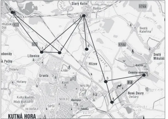
Fig. 3. Two Settlement patterns in Kolín Flatland. Blue houses symbolize the Stroked Pottery culture settle-ments, green ones the Únětice Culture. Lines around the arbitrarily chosen centres show the one-hour and two-hour walk limits
The second half of the view forms a large flatland which is limited at the West by a low chalk terrain wave nearby Kolín and at the East by an upland called Chvaletická pa-horkatina, the northern horizon is limited by undulating country of Konárovická obora with the hill Oběšák on the other bank of the river Elbe.
Nearby Libenice, 17 settlement localities of the Stroked Pottery Culture were discov-ered and incorporated into the settlement pattern. Within one-hour walk reach, six of the localities are situated: Kolín-Šťáralka, Starý Kolín, Hlízov, Hořany, Malá Vysoká and Nebovidy. Between one and two hour limits five more can be reached: Kolín – settle-ment at the Polepka brook, Polepy, Červené Pečky, Dobešovice and Malín. And about two-hour walk was needed to get to other five localities: Štítary, Ratboř, Kutná Hora (several localities, c. 5 km, but more difficult terrain), Nové Dvory and Svatý Mikuláš.
Unfortunately, to analyse the view from the Únětice Culture settlement in Polepy is not possible, because the locality is partly built over. But it can be deduced from a contoured map. The settlement in Polepy is situated between the local part called “Na Vinici” and the road to Kolín, on the west edge of Polepy. The northeast view is closed by the Polepský hill and on the northern side the Kaňk Hills are visible. The site itself was situated on a SE slope to the Polepka brook and was not much visible from the sur-rounding landscape.
Nearby Polepy, 19 settlement localities of Aunjetitz culture are situated. Within one hour one can walk to eight localites (Kolín brickkilns 2, Kolín – Kutnohorské předměstí, Kolín at the bank of the Elbe, Radovesnice I, Nebovidy, Červené Pečky, Hořany). Be-tween one and two hour limits eight more are situated (Nová Ves, Kolín – Chaloupka, Křečhoř 2, Kaňk, Libenice – Skalka, Hlízov, Starý Kolín). Two and half hour takes to get to two more sites (Nové Dvory 2).
When both the Stroked Pottery and the Únětice Culture settlement structures are projected into one map – it is evident, that they differ. They are similar in density, but different in places chosen for settling down. This point is very interesting when we con-sider that they both were sedentary, agricultural cultures and their subsistence did not differ dramatically.
Dominant position of the hills represents the feature that is the same for the eastern and the western part of the surveyed area. However, the surveyed area differs in its east-ern and westeast-ern parts. The courses of the brooks in the easteast-ern part are mostly regulated, Fig. 4. A view to the Kaňk hills from the Libenice Stroked Pottery culture site. From the left: Kaňk, Grunta, Velký and Malý Kuklík. This way entrances to houses are oriented
however also in unregulated parts are not countersunk, their valleys are shallow and wide, as e.g. Hořanský brook between Čertovka and Libenice. In the western part the brook valleys are deeply countersunk and create deep hidden valleys where the oldest part of current villages are situated, e.g. Hluboký Důl, Polepy or Nebovidy. These hidden me-anders often appear in fieldwork notes from our research as ideal places to settle down, e.g. Nebovidy – the most attractive, most hidden place [to] settle down (fieldwork note – 26 July 2008, 30°C, sunny day, Jana Ilková & Marek Kopeć). However, the settlements of the Stroked Pottery Culture are not situated at or nearby such places. These from current view attractive and favourable places were inhabited by people with the Únětice Culture, but the sites of the Stroked Pottery Culture are without exception situated in open-space/flatland or very mild slope (Libenice and Svatý Mikuláš), exposed to wind and sun. They are not hidden but open to be seen and exposed to weather foulness.
Most of the Stroked Pottery Culture settlements in the Kolín Flatland are situated at a total flatland or at a very mild slope openly in the landscape, on the other hand most of the Únětice Culture settlements there are situated in hidden positions, at the brook‘s valleys. Settlements of these two cultures are situated in different positions as is clear from the map (fig 3).
The Kaňk Hills form the southern border of the surveyed area. The open space of the flatland,the ‘ironed’ great fields (fieldwork note – 27 July 2008, 30 °C, sunny day, Jana
Ilková & Marek Kopeć) that spread from the hills to the river was usually perceived nega-tively. And walking in the direction from the hills to the river was unpleasant: „The path from Libenice to Starý Kolín is long and boring [...]. The landscape is absolutely open and the destination seems not getting closer, it stays inaccessible and far away” (fieldwork note – 31 July 2008, 30°C, sunny day, Josef Dufek & Lenka Hanovská). The flatland as if never ending and not limited brings a feeling of human smallness and being lost in it.
Typical for the Kolín Flatland is that it is open to far distances. Even several meters of height give a good visual control of the surroundings. The intervisibility among particu-lar settlements is considerable. The intervisibility is even better in the eastern part. From the Libenice Stroked Pottery Culture site, three other settlements of the same culture are visible (see Fig. 5).
REFLECTIONS ON THE TYPE OF SETTLING DOWN IN THE KOLÍN FLATLAND IN THE MIDDLE NEOLITHIC (STROKED POTTERY CULTURE) AND THE EARLY BRONZE AGE (ÚNĚTICE CULTURE)
People in the Middle Neolithic chose places for their settlements in the Kolín Flat-land that are not hidden from view and thus cannot be considered as refuge; they rep-resent the opposite, they are built at open spaces. The settlements are to great extent intervisible and all are visible from the Kaňk Hills and the hills are visible from all the sites, especially the most dominant one – the hill of Kaňk.
Such type of settlement is not possible to defend. It can be an expression of some fatalism or an expression of feeling secure. At the settlement in a flatland, all the sky is visible. Maybe, it was taken as important to watch the celestial phenomena, important for agricultural year, from the site. This is not so impossible conclusion considering that the Neolithic era brought the cults accenting cyclic time, world renewing, etc. (Cassirer 1953; Eliade 1993). Turning the interest to the sky and to reflecting the celestial object movements the space of human life becomes stretched between earth and sky. The verti-cal dimension became elemental for the organization of the human space. This vertiverti-cal dimension of the human space is often represented by the mountain. An interest in the vertical line is proved also by our phenomenological research. According to the research, the flatland and open space was perceived rather negatively, as boring and as a space where a person disappears, on the other side the hills were perceived positively, as an aim of the road and the point to orient oneself.
In this landscape, the hill of Kaňk dominates and makes the gravity axis. As Mojmír oryna puts it when writing about organization and hierarchy of space ‘Life space of an archaic society is delimited by the space that is dominated by the power of its sacred gravity axis’ (Horyna 1990–1995). In the scenery, such place is a mountain, a prominent elevation. The mountain is a place where earth and sky meet. When we go a bit further in our consideration, the Kaňk hill could besides the natural axis also represent ‘a sacred mountain’. The mechanism how the profane became sacred was a topic ofe.g. Mircea Eliade who noted: ‘Some rock became sacred because its only existence is hierophany, it
is inflexible, impassible, it is something that the man is not. It resist to time, its reality is augmented by lasting’ (Eliade 1993, p. 10). In this consequence it is very important that in Libenice, the house entrances were oriented towards the hills. Neolithic houses are usually oriented in the NS direction, but in this case they are a bit diverted from this direction and they point towards the scenery of the hills of Kaňk, Grunta and Malý and Velký Kuklík.
Settlements of the other chosen culture – the Únětice Culture – are situated on the slopes of brook valleys and they are in more hidden positions, while their graveyards are situated high above the valleys and very visible. How to interpret such a type of settling down? The Únětice Culture people may have wanted to hide themselves this way, how-ever, the graveyards were situated quite close to the settlements and the settlement den-sity is quite high. Practical reasons can be considered – such as nearness of water source and settlements being hidden from wind. Collected subjective data from my co-workers speak about the pleasant feelings of home and security generated by these positions. The settlement settings‘ analysis showed that the inhabitants of the settlements probably con-nect themselves in the landscape to water or the streams. This idea could be supported by the finds of pebbles in Únětice graves and also by the find of a deposit of bronze and copper artefacts at the bank of the brook Polepka in the village of Pašinka attributed to the Únětice Culture (Dvořák 1936). Water is best characterized by change; it is not solid and stable as a mountain, it is always passing, and very ambivalent. In mythology, water is characterized as a nurturer, as a creator, as a destroyer, as a divider of the living and the dead (Lembke 1994) and also as a symbol of womanhood (Feldhaus 1995).
As most of the settlements from the Middle Neolithic is situated in the Kolín Flat-land to see the mountain – the Kaňk hill and their entrances are opened towards it, than the mountain is interpreted as an important gravity axis. The vertical dimension wins a dominating significance in the organization of space. Settlements of the Early Bronze Age people are in the same space placed differently, they are nearby brooks and streams, sometimes hidden in their valleys. The Early Bronze Age people put pebbles from the brooks into their graves and deposited their treasures at the brooks’ banks. Two different affinities can be deduced: the Middle Neolithic to the mountain and the Early Bronze age to the streams. When we go in this interpretation a bit further, stability seems to have importance for the Middle Neolithic people while change and fluidity for people of the Early Bronze Age.
DISCUSSION AND CONCLUSION
Certainly, there are limits to such interpretation and the most important ones are that we do not have available all traces of activities of the past people and most of the sites are not dated to the particular phase of the culture but usually only to the Stroked Pottery of the Únětice Culture in general and thus the reconstructed taskscape is only approximated. Other problem is that we cannot be sure how precisely the landscape changed, though the vegetation cover can be reconstructed from palynology data as well as the measure of surface erosion from pedology data, etc. After stating these important
limits of the method, the question – why to use this method – must be answered. The first reason is to get some more subjective approach to archaeological data and thus to bring a complement to traditional interpretation. This way we can approach or get closer to the way the people of the past used the landscape, thus the way they perceived it. It is an attempt to understand why they lived where they lived, why did they chose the particular places. And as I have shown, some patterns can be identified in the surveyed area, people of each culture chose for their settlements very similar places that differ from the other culture’s sites. In social science landscape is not only a set of natural and anthropogenic features connected with a certain relief, but rather a set of ideas we create about it. A landscape is also our interpretation of it and our understanding. A landscape is always a landscape for somebody; she/he feels it, and understands it as a compact and understandable complex. The method can serve as a way to understand the past land-scape, ergo the landscape of the past people.
In my project I tried to approach the landscapes of the people from the Middle Neo-lithic and the Early Bronze Age using the method of phenomenological analysis. Two different cultures behaved differently in the same landscape and this difference was inter-preted as a manifestation of their affinity to different elements of the landscape. For the Middle Neolithic people the vertical dimension wins a basic, dominating significance in the organization of the human space, a mountain – for most of the settlements are situ-ated to see it and their entrances are opened towards it. For the Early Bronze Age people brooks and streams were important, that is the reason why they settled on their slopes, put pebbles into their graves and deposited their treasures at their banks. Stability seems to have importance for the Middle Neolithic people while change and fluidity for the people of the Early Bronze Age.
BIBLIOGRAPHY
Bender B., Hamilton S., Tilley C. 2007. Stone Worlds: Narrative and Reflexivity in Landscape Archaeology, Walnut Creek CA: Left Coast Press.
Cassirer E. 1953. The Philosophy of Symbolic Forms: Mythical thought. New Haven & London: Yale University Press.
Dvořák F. 1926. Pohřebiště únětické kultury v Polepech u Kolína. Památky archeologické, vol. 35, pp. 22–45.
Dvořák F. 1936. Pravěk Kolínska a Kouřimska. Soupis archeologických památek, Kolín. Eliade M. 1993. Mýtus o věčném návratu. Praha: Οικουµενε.
Feldhaus A. 1995. Water and womanhood: religious meanings of rivers in Maharashtra, New York: Oxford University Press.
Fleming A. 1999. Phenomenology and the Megaliths of Wales: A Dreaming too Far? Oxford Journal of Archaeology, vol. 18 (2), pp. 119–125.
Fleming A. 2005. Megaliths and post-modernism: the case of Wales, Antiquity, vol. 79 (306), pp. 921–932.
Foucault M. 1978. Politics and the study of discourse, Ideology and Consciousness, vol. 3, pp. 7–26. Foucault M. 1979. My body, this paper, this fire,Oxford Literary Review, vol. 4 (1), pp. 9–28. Hamilton S., Whitehouse R. 2006. Phenomenology in Practice: Towards a Methodology for a
Hirsch E., O’Hanlon M. 1995. The Anthropology of Landscape: Perspectives on Place and Space. Oxford studies in social and cultural anthropology, Oxford, New York: Clarendon Press, Oxford University Press.
Ingold, T. 2000. The Perception of the Environment. Essay on Livehood, Dwelling and Skill. London/NY: Routledge.
Horyna M. 1990–1995. Sakrální architektura, Archiv článků z let 1990–1995. http://www.souvislosti. cz/archiv/horyna2–94.htm, 19.7. 2009.
Hrala J., Vávra M. 1989. Kolín, Výzkumy v Čechách 1986–7, p. 79. Křepelková J. 1964. Kolín, Bulletin Záchranného oddělení 1964, pp. 20–21.
Lembke J. 1994. Skinny-dipping: and other immersions in water, myth, and being human, University of Virginia Press.
Moravec J. 2007. Svatý Mikuláš, Výzkumy v Čechách 2004, p. 233. Rulf J. 1985. Rohozec, Výzkumy v Čechách 1982–83, p. 158.
Moucha V. 1954. Rozbor únětického pohřebiště v Polepech u Kolína, Archeologické rozhledy, vol. 6, pp. 502–503, 523–536.
Moucha V. 1987. Zajímavý nález z únětického pohřebiště v Polepech u Kolína, Archeologické rozhledy, vol. 39, pp. 121–128.
Pavlů I. 1997. Kutná Hora, Výzkumy v Čechách 1993–5, pp. 118–119. Pavlů I. 2003. Kaňk, Výzkumy v Čechách 2000, p. 97.
Pavlů I., Zápotocký M. 1981. Nové Dvory, Výzkumy v Čechách 1976–77, p. 93.
Rulf J. 1983. Přírodní prostředí českého neolitu a eneolitu, Památky archeologické, vol. 74, pp. 35–95. Rulf J. 1985. Rohozec, Výzkumy v Čechách 1982–83, p. 158.
Rulf J., Valentová J. 1995. Hořany, Výzkumy v Čechách 1982–83, p. 39. Sedláček Z. 1978. Štítary, Výzkumy v Čechách 1975, p. 88.
Sedláček Z. 1981. Radovesnice I, Výzkumy v Čechách 1976–7, p. 124.
Smith, A.T. 2003: The political landscape: constellations of authority in early complex polities,Berkeley, Los Angeles, London: University of California Press.
Steklá M. 1961. Chata kultury s vypíchanou keramikou v Libenicích u Kolína. Památky archeologické, vol. 52, pp. 85–93.
Svobodová L. 1968. Kolín. Bulletin Záchranného oddělení 1968, p. 58. Šumberová R. 2000. Malín/Nové Dvory, Výzkumy v Čechách 1998, p. 122. Šumberová R. 1997. Kutná Hora, Výzkumy v Čechách 1993–5, p. 122. Šumberová R. 1998. Kutná Hora, Výzkumy v Čechách 1996–7, p. 92.
Tilley Ch. 1994. A Phenomenology of Landscape: Places, Paths and Monuments, Oxford: Berg.
Tilley C. 2004a. Mind and body in landscape research, Cambridge Archaeological Journal, vol. 14 (1), pp. 77–80.
Tilley C. 2004b. The Materiality of Stone: Explorations in Landscape Phenomenology, Oxford: Berg. Tvrdík R. 2003. Kolín, Výzkumy v Čechách 2001, pp. 105–6.
Tvrdík R. 2007. Kolín, Výzkumy v Čechách 2004, p. 97. Tvrdík R. 2003. Štítary, Výzkumy v Čechách 2001, p. 273. Valentová J. 1992. Jakub. Výzkumy v Čechách 1988–89, p. 49.
Valentová J., Rulf J., Pavlů I. 1995. Libenice-Skalka, Výzkumy v Čechách 1990–92, p. 171. Vávra M. 2000. Nová Ves I, Výzkumy v Čechách 1998, pp. 120–121.
TWO SETTLEMENT PATTERNS IN THE KOLÍN FLATLAND – A PHENOMENOLOGICAL ANALYSIS
Summary
The article deals with the phenomenological research of settlement strategies of two cultures in the Kolín Flatland: the Stroked Pottery and the Únětice (Aunjetitz) Culture. As centres for the constructed settlement structure, the most famous localities of these two cultures in the Kolín Flatland were selected – Libenice for the Stroked Pottery culture and Polepy for the Únětice culture.
As a theoretical concept for the research I have chosen taskscape, defined as a socially constructed space of human activities (Ingold 2000). The research was inspired by phenomenological research of Christopher Tilley (1994; 2004a; 2004b; Bender, Hamilton, Tilley 2007). The phenomenological ar-chaeological research comprised of collecting and processing sensual data of landscapes and places and analysing them together with the data from archaeological research. As a research tool human body was used and as a method its most ordinary activity – walking.
The fieldwork took place in the summer and autumn 2008 and in February 2009. We concentrated on browsing through the landscape at the southern side delimited by the Kaňk hills and the northern side by the today’s Elbe river-basin. Two-hour walk to the East and West from the centre of the sur-veyed area formed the other two boundaries. At the beginning we observed the localities setting in the landscape and than, so as to (re)construct the taskscape, we walked to the nearest localities of the same culture and collected the data. Other tracks headed to possible observatory points and along the brooks towards the Elbe and back and also tracks alongside the nowadays riverbed of Elbe were walked.
When both the Stroked Pottery and the Únětice Culture settlement structures were projected into one map, it became evident, that they differed. They are similar in density, but differ in places chosen for settling down. Two different cultures behaved differently in the same landscape and this difference was interpreted as a manifestation of affinity to different elements of the landscape. For the Middle Neolithic people the vertical dimension wins a basic, dominating significance in the organization of human space, a mountain – for most of the settlements are situated to see it and their entrances are opened towards the Hills or towards the most significant one – the Kaňk hill. For the Early Bronze age people brooks and streams were important, that is why they settled on their slopes, put pebbles into their graves and deposit their treasures at their banks. When we go in this interpretation a bit further, stability seems to have importance for the Middle Neolithic people while change and fluidity for the people of the Early Bronze age.
Karolína Pauknerová Centra pro teoretická studia Jilská 1, 110 00 Praha 1 Česká Republika [email protected]