Get2School : An android application to track school location
Mr. Upendra Mishra
1, Rashi Gupta
2, Shubham Singh
3, Subhanshu Varshney
4, Swati Yadav
51Assistant professor, Information Technology, IMSEC Ghaziabad 2,3,4,5Students, Information Technology, IMSEC Ghaziabad
---***---Abstract -
Proposed paper presents design of suchmonitoring system for emergency of people. Navigators have always been a necessity of human life.. The developments of advanced electronics have brought revolutionary changes in these fields. In this paper, we will present a school locating application that employs a GPS module to find the location of a school in a particular location. Initially the GPS takes input data from the satellite and stores the latitude and longitude values in AT89s52 microcontroller's buffer. If we have to locate the school, we need to provide the location and circumference (in km) as the input. A webpage is specifically designed to view the school’s location on Google maps. By using the concept introduced in this paper, we can locate hospitals, ATM, medicals, hostels etc. in the same fashion.
Key Words: GPS Tracker, TRILATERATION, GNSS, GIS,
GPRS
1. INTRODUCTION
GPS technology is a great boon to anyone who has the need to navigate either great or small distance. The Global Positioning System (GPS) is a burgeoning technology, which provides unequalled accuracy and flexibility of positioning for navigation, surveying and GIS data capture. This wonderful navigation technology was actually first available for government use back in the late 1970s. The Global Positioning System (GPS) is a radio based navigation system that gives three dimensional coverage of the Earth, 24 hours a day in any weather conditions throughout the world. The technology seems to be beneficiary to the GPS user community in terms of obtaining accurate data about 100 meters for navigation, meter-level for mapping, and down to millimeter level for geodetic positioning. GPS technology has tremendous amount of applications in Geographical Information System (GIS) data collection, surveying and mapping.
(GPS) technology is a great boon to anyone who has the need to navigate either great or small distances. The Global Positioning System (GPS) is a burgeoning technology, which provides unequalled accuracy and flexibility of positioning for navigation, surveying and GIS data capture. This wonderful navigation technology was actually first available for government use back in the late 1970s.[1]
GPS Tracking System works and where it is useful in real world environment. We compare different algorithms like Localization algorithm, Kalman Filter algorithm and methodologies like GPS, GPRS, GSM, GIS, GSM and RFID.[2]
The precision of GPS positioning under worse situation that you can see few GPS satellites because they increase the number of satellites which are available to use for position calculating. However, they require much time and expensive device for their infrastructure. We paid attention to GPS calculating method itself. We adapted Kalman filter to GPS positioning calculation. We improved the precision and accuracy of SPS positioning in stand-alone mode under worse situation adapted the Kalman filter parameter.[3]
Another study was conducted in which tracking living beings and devices using the Global Positioning System (GPS) has become prevalent and indispensable over the last few years. Applications range from military and national security to personal safety and comfort. This paper reviews some of the recent application areas and discusses the benefits and issues of GPS tracking. It then presents a software architecture of a general tracking system to locate lost and misplaced devices.[4]
Another study with objective. It has a GPS Unit, that continuously moves with the car and will calculate the coordinates of each position and ii). Communicate to GSM device which is installed in both Transmitter and receiver section. [5]
2. COMPONENTS OF GPS
2.1 Hardware
Hardware is the computer on which a GPS operates. Today, GPS software runs on a wide range of hardware types, from centralized computer servers to desktop computers used in stand-alone or networked configurations.
2.2 Software
Softwares used in this project are open source softwares. Key software components are:
2.2.1 Firebase
Firebase is Google's mobile platform that helps you quickly develop high-quality app data.
2.2.2 Android Studio
2.2.3 Google Map API
Millions of websites and apps use Google Maps APIs to power location experiences for their users.
3. STUDY AREA
We have collected information of the schools which are in Delhi ncr region which includes Delhi, Ghaziabad and Noida. The information about each has been taken from the data provided by the google maps software available on google. The database contains the schools only which are available on internet till March, 2018.
4. PROPOSED METHODOLOGY
4.1 GPS Tracker
A GPS tracking unit is a device that uses the Global Positioning System to determine the precise location of a vehicle, person, or other asset to which it is attached and to record the position of the asset at regular intervals. The recorded location data can be stored within the tracking unit, or it may be transmitted to a central location data base, or internet-connected computer, using a cellular (GPRS), radio, or satellite modem embedded in the unit. A GPS tracking system uses the GNSS (Global Navigation Satellite System) network. This network incorporates a range of satellites that use microwave signals which are transmitted to GPS devices to give information on location vehicle speed, time and direction. Some systems will store the data in the GPS tracking system itself (known as passive tracking) and some send the information to a centralized database or system via a modem within the GPS system unit on a regular basis (known as active tracking).
4.2 Measuring Distance to Satellites
The first step in measuring the distance between the GPS receiver and a satellite require measuring the time it takes for the signal to travel from the satellite to the receiver. Once the receiver knows how much time has elapsed, it multiplies the travel time of the signal times the speed of light (because the satellite signals travel at the speed of light, approximately 186,000 miles per second) to compute the distance. Distance measurements to four satellites are required to compute a 3-D (latitude, longitude and altitude) position.
4.3 Trilateration
The Global Positioning System (GPS) is actually a constellation of 27 Earth-Orbiting satellites (24 in operation and three extras in case one fails). A GPS receiver’s job is to locate four or more of these satellites, figure out the distance to each, and use this information to deduce its own location. This operation is based on a simple mathematical principle called TRILATERATION.
5. ALGORITHMS USED
5.1 Localisation
Localization improvement algorithm in GPS interfering spots by integrating information of multiple sensors such as gyroscope and compass in smart phones. The proposed algorithm is implemented in a smart phone.
There are 3 steps to implement this algorithm.
Structure of Algorithm:- The proposed algorithm consists of three steps:
1.Finding the correct direction of movement. 2. Obtaining the distance moved, and
3. Integrating the prior results and GPS location information.
To obtain the direction of movement, get the heading from the built-in compass in the smart phone. However, the compass is highly dependent on the ambient magnetic field so it has lower accuracy. To obtain more accurate values of the user's heading, we stabilize the heading value of the compass by recurrence processing of the data. After obtaining the direction of the movement of the user, the distance moved is calculated by the summation of the distances of each coordinate from the GPS location information.
5.2 Kalman Filter Algoritm
Kalman filtering, also known as linear quadratic estimation (LQE). Kalman filter is implemented to reduce GPS errors and thus it increases the accuracy of the localization system. The algorithm works in two-step process.
1. In the prediction step, the Kalman filter produces estimates of the current state variables, along with their uncertainties.
2. Once the outcome of the next measurement (necessarily corrupted with some amount of error, including random noise) is observed, these estimates are updated using a weighted average, with more weight being given to estimates with higher certainty.
Main aim of the project is to provide the user a single platform for searching various schools which also classifies them according to the board.
Fig - 1 : Sign In Activity
Now we have to enter the requirements which are as shown in figure 2.
1.Locality: we will provide the locality where we want to search.
2.Radius: now we have to enter the radius where we want to search.
We have to provide the radius in meters while entering the value for searching the school according to radius.
e.g: Suppose we want to search school in the radius of 5 kilometers. So we have to enter 5*1000=5000 meters.
6. OBJECTIVES
The objective of this application is to find the no of schools in a given radius in which the user wants to search for.
1. First of all the application will provide the precise current location of the user.
2. In case he wants to search the schools in another region, the user can manually enter the location and the GPS will search in that particular region.
3. Now, once the user will enter the radius distance, it will tell the no of schools which are affiliated to the prescribed boards in that particular radius.
4. From the various schools in the list provided the user can now select any school and get the related information about that school like contact information and other information. 5. The user can now click for the route map and he will be given directions from his location to the destinationpoint.
7. CONCLUSION
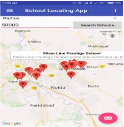
[image:3.595.308.562.389.649.2]Now all the schools according to our given requirement will pop up on the screen as shown in figure 3.
Fig - 3 :Schools pop up list
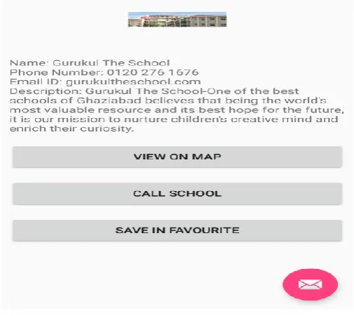
[image:3.595.35.288.510.758.2]Fig - 4 : Clicked school related details
Once we click on the schools all the details about that school will come and we will have various options as shown in figure 4.
1.View on map: This will take us to google maps and will show us the way to reach there.
2.Call school: by clicking on this option a phone call to the contact no. provided by the school will will held.
3. Save in favourite: by clicking on this option we can add that school in favourite list .this will help us to reduce the wastage of time, when we will login next time this information will be retrieved easily.
Result : We have tested this application for 50 schools in
the N.C.R region. The output is accurate for all the schools. The application is working smoothly. So the accuracy is 100% .
8. APPLICATIONS
The project that has been introduced here can be used for variety of applications–
1. Surveying and Mapping
2.Precisely locates the schools in the given location 3. Provides personal and various other details 4.Provides the shortest path to reach the destination 5.Provides the distance between the schools in that location 6. Remote Sensing and GIS
9. FUTURE SCOPE
In future, we can add the following fields to provide a lot of options for the user at the same platform:
1. Medicals 2. Colleges 3. Restaurants 4. Hospitals 5. ATM etc.
Other facilities such as taking appointments at schools and hospitals, making orders at restaurants, paying bills etc. can be provided for the users at the same platform.
There will be a user’s account keeping record of all his activities which can help the user to keep track and it will be helpful in relocating the same place very easily.
10. ACKNOWLEDGEMENT
We are very thankful to our project guide Asst. Prof. Mr Upendra Mishra, Dept of Information Technology, IMS engineering college, Ghaziabad for his valuable guidance and assistance, without which the accomplishment of the task would have never been possible. We also thank him for giving us opportunity to explore into the real world and realize the interrelation.
11. REFERENCES
[1] ijcaonline.org/volume109/number8/pxc3900994.pdf
GLOBAL POSITIONING SYSTEM FOR OBJECT TRACKING
[2]
ijarcet.org/wp-content/uploads/IJARCET-VOL-3-ISSUE-11-3762-3765.pdf
[3]
https://www.scribd.com/doc/6698521/GPS-Final-Report
[4]
https://www.customwritings.com/blog/sample-research-papers/research-paper-gps.html
[5] VikramKulkarni&ViswaprakashBabu“embedded smart
car security system on face detection”, special issue of IJCCT, ISSN(Online) : 2231-0371, ISSN(Print):0975-7449,volume-3, issue-1
[6] Chen, H., Chiang, Y. Chang, F. H. Wang, Toward
Real-Time Precise Point Positioning: Differential GPS Based on IGS Ultra Rapid Product, SICE Annual Conference, The Grand Hotel, Taipei, Taiwan August 18-21, (2010)
[7] GPS Systems Segments” -An article by US Naval
Observatory
[9] Asaad M. J. Al-Hindawi, IbraheemTalib, “Experimentally
Evaluation of GPS/GSM Based System Design”,Journal of Electronic Systems, Volume 2 Number, 2 June, 2012
[10] KunalMaurya , Mandeep Singh, Neelu Jain, “Real
TimeVehicle Tracking System using GSM and GPS Technology- An Anti-theft Tracking System”, International Journal of Electronics and Computer Science Engineering, ISSN 2277-1956/V1N3-1103-1107
[11] www.engpaper.com/gps-tracking.html
[12] research.ijcaonline.org/volume109/number8/pxc3900
994.pdf
[13]
ijarcet.org/wp-content/uploads/IJARCET-VOL-3-ISSUE-11-3762-3765.pdf
[14]
https://www.magicbricks.com/School-Block-in-New-Delhi-map-mapid-+uZvhYj6V1c=
[15] https://www.mapsofindia.com/maps/delhi/
[16] Localization algorithmsof Wireless Sensor Networks: