Technology (IJRASET)
©IJRASET 2013: All Rights are Reserved
89
Drainage Evaluation of Doddhalla Sub-basin,
Karnataka, India Using GIS
Sreenivasa. A1, Ajaykumar N. Asode2, Shilpa Murgod3
1,2,3
Dept of Studies in Geology, Karnatak University, Dharwad, Karnataka, India.
Abstract— Morphometric analysis of Doddhalla Sub-basin, which is a tributary of River Malaprabha, Karnataka, India was
carried out to study its drainage network and characterictics. Sub-basin is spread over an area of 293 km2 with highest stream
order of fifth order. Strahler’s pattern of ordering the stream order and number was adopted. Large number of first order streams indicates the intensity of permeability and infiltration. The pattern of the drainage is dendritic to sub-dendritic. The average bifurcation ratio value 4.73, indicating no dominant structural control but geomorphic. From the values of form factor (0.42), elongation ratio (0.41) and circulatory ratio (0.53) it was concluded the shape of basin to be elongated. Drainage density
value of 1.09 km2 suggests, coarse texture and highly permeable subsurface. Stream frequency value suggests the study area to
be having relatively low relief, high infiltration and dense vegetation cover. Thus in the present study GIS applications are found to be very competent and helpful in drainage evaluation.
Keywords— Doddhalla Sub-basin, Karnataka, Morphometry, Bifurcation ratio, Drainage density, GIS.
I. INTRODUCTION
Morphometry is the measurement and mathematical analysis of the earth’s surface, shape and dimension of its landforms and this analysis could be achieved through measurement of linear, aerial and relief aspects of basin and slope contributions [1, 10]. Morphometric analysis of a river basin provides a quantitative description of the drainage system, which is an important aspect of the characterization of basins [19]. Morphometric assessment helps to elaborate a primary hydrological diagnosis in order to predict approximate behaviour of a watershed directly coupled with geomorphology and ecology [4]. Evaluating morphometric parameters requires watershed boundary delineation, preparation of drainage map and its ordering, measuring the stream length and basin area, computing drainage density and bifurcation ratio, etc., which helps to understand the nature of drainage basin [10, 11]. Many geographers, hydrologists, hydrogeologists, geoscientists and researchers from different parts of the world have studied and evaluated various kind of basins using both conventional method and geographical information system [8, 9, 11, 12, 16, 17]. In the present study an attempt has been made to study drainage network and evaluate morphometric characteristics of Doddhalla Sub-basin. Furthermore, suggest measures for proper planning, management and sustainable development of water resources.
II. STUDY AREA
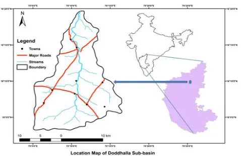
[image:2.612.187.426.550.705.2]The present study area, Doddhalla Sub-basin is tributary of Malaprabha River and covers an area of 293 km2, covering major portion in Bagalkot district and small part of Belgaum district, Karnataka, India. Geographical it is located between 7508’24”E longitude and 16010’14”N latitude and is covered in Survey of India (SOI) toposheets numbered 47P/3; 47P/4 and 47P/8.The climate is hot and dry with temperature reaching its peak in the month of April and May while December and January coolest.
©IJRASET 2013: All Rights are Reserved
90
The Doddhalla Sub-basin forms part of Kaladgi Basin. The different lithounits exposed in the study area includes limestone, sandstone, clays and shales, quartzites and conglomerates. While numerous quartz veins and few basic dykes are also observed in some parts [13].III. MATERIALS AND METHODS
Survey of India (SOI) toposheets of 1:50,000 scale were used to evaluate the morphometric analysis of sub-basin. Sub-basin boundary was demarcated and different streams were digitized in GIS environment using ArcGIS v10. Linear-, areal- and relief- aspects were examined of Doddhalla sub-basin following standard laws and postulates of different researchers [6, 19].
IV. RESULTS AND DISCUSSION
A. Linear Aspect
1) Stream Order (U) And Stream Number (Nu): The ordering of streams is the first step in drainage basin analysis. Strahler’s [19]
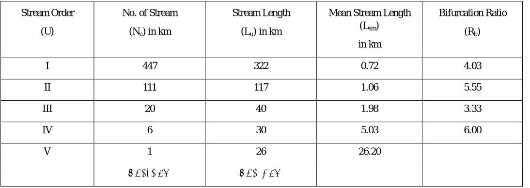
scheme of hierarchial ranking was adopted in the study area. Doddhalla Sub-basin has upto fifth order stream which consists of 447 first order streams, 111 second order streams, 20 third order streams and 6 fourth order streams. The existence of more first order streams in a basin indicates complex hilly and compact nature of bedrock [9]. Also as the stream order increases the stream number decreases. Table 1 shows the details of stream order (U), stream number (Nu).
2) Bifurcation Ratio (Rb): Horton [6] defined bifurcation ratio (Rb) as the ratio of the number of streams of any given order to the
number in the next lower order. Rb varies from one order to next order and these irregularities depend on the surface and sub-surface lithology of the drainage basin [19].The Rb values of the study area are presented in Table 1 and it suggests the basin is not influenced by any structural control or disturbances but geomorphic [2].
3) Stream Length (Lu) And Mean Stream Length (Lsm): Stream length (Lu) has been calculated using law as proposed by Horton [7].
This was calculated using ArcGIS v10 and Lu was found to be 536 km (Table 1). Mean stream length (Lsm) is a characteristic
property related to the size of drainage network components and its contributing basin surface [19]. The Lsm values of the study area
[image:3.612.36.583.442.636.2]vary from 0.72 to 26.20 (Table 1). Also, Lsm of any given order is greater than that of the lower order and less than that of its next higher order.
Table 1 Linear aspects of Doddhalla Sub-basin.
Stream Order
(U)
No. of Stream
(Nu) in km
Stream Length
(Lu) in km
Mean Stream Length (Lsm)
in km
Bifurcation Ratio
(Rb)
I 447 322 0.72 4.03
II 111 117 1.06 5.55
III 20 40 1.98 3.33
IV 6 30 5.03 6.00
V 1 26 26.20
Technology (IJRASET)
[image:4.612.64.552.87.452.2]©IJRASET 2013: All Rights are Reserved
91
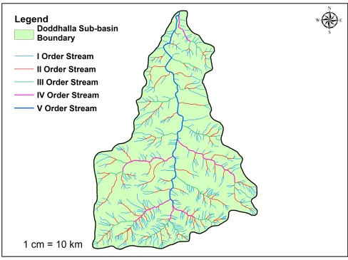
Figure 2 Drainage map of Doddhalla Sub-basin.
B. Areal aspect
1) Form Factor (Ff): Ff can be defined as the ratio of basin area to square of the basin length [6]. The value of Ff of the study area is
0.42 (Table 2), indicating an elongated shape for Doddhalla Sub-basin.
2) Elongation Ratio (Re): Re may be defined as the ratio between the diameter of the circle of the same area as the drainage basin. Re
value of the study area is found to 0.41 (Table 2), indicating high relief with steep slope and elongation. If Re value nears 1.0, then
the basin have low relief and circular in shape.
3) Circulatory Ratio (Rc): Rc is the ratio of the area of a basin to the area of a circle having the same circumference as the perimeter
of the basin. Rc is influenced by the lithological characteristics of the basin. Rc value of Doddhalla Sub-basin is found to be 0.53
(Table 2), which suggests elongated shape.
4) Drainage Density (Dd): Dd is defined as the total stream length in a given basin to the total area of the basin [19]. Dd indicates the
closeness of spacing of channels, thus providing a quantitative measure of the average length of stream channel for the whole basin. It depends upon both the climatic and physiographic characters of the basin. According to Strahler [19] high Dd indicates weak or
impermeable sub-surface strata, sparse vegetation and fine texture while low Dd leads to coarse drainage texture.
©IJRASET 2013: All Rights are Reserved
92
value of the study area is 2.0 (Table 2), indicating relatively lower relief, high infiltration and dense vegetation cover.6) Drainage Texture (T): T is a measure of relative channel spacing in a fluvially dissected terrain, which is also influenced by climate, vegetation, lithology, soil type, relief and geomorphic stage of basin development [15].
[image:5.612.48.591.178.562.2]T value of Doddhalla Sub-basin is 3.65 (Table 2), which falls under coarse texture category.
Table 2 Areal aspects of Doddhalla Sub-basin.
Sl.
No. Areal Aspect Formula Reference Value
1 Form factor (Ff)
Ff=A/Lb2 where A=Area of the basin
(km2), and
Lb=Basin length (km)
Horton, 1932 &
1945 0.42
2 Elongation ratio (Re)
Re=D/Lb =1.128√A/Lb where
D=Diameter of a circle of the same area(A) as the basin, A=Area of basin (km2), and Lb=Basin length
Schumm, 1956 0.41
3 Circulatory ratio (Rc)
Rc=4πA/P2 where A=Area of the
basin (km2), and P=Perimeter of basin (km)
Miller, 1953 &
Strahler, 1964 0.53
4 Drainage density (Dd)
Dd=∑Lu/A where Lu=Total length of
the stream segments of that particular order, and A=Area of the
basin (km2)
Horton, 1945 1.82
5 Stream frequency (Fs)
Fs=∑Nu/A where Nu=Total number
of stream segments of the order ‘u’, and A=Area of the basin (km2)
Horton, 1932 2.0
6 Drainage texture (T) T=Dd*Fs where Dd=drainage density, and Fs=Stream frequency
Horton, 1945 3.65
C. Relief Aspect
1) Basin Relief (R): R can be defined as the difference between maximum and minimum elevation of basin. R also determines the stream gradient and influences flood pattern and volume of sediment that can be transported [5].The value of R for Doddhalla Sub-basin is 431 meters (Table 3).
2) Relief Ratio (Rr): Rr is the ratio of basin relief to basin length and is widely accepted as an effective measure of gradient aspects
of basin [14]. High relief ratio indicates quick time of concentration, flow velocity and erosional proneness. Rr value of the
study area is 0.015 (Table 3).
3) Ruggedness Number (Rn): Rn is a dimensionless quantity derived from product of basin relief and drainage density. A high
value of Rn indicates small steep valleys prone to flood risk than broader valleys with low relief and having same drainage
Technology (IJRASET)
©IJRASET 2013: All Rights are Reserved
93
Table 3 Relief aspects of Doddhalla Sub-basin.
Sl.
No. Relief Aspect Formula Reference Value
1 Basin Relief (R) in meters
R= (Maximum - Minimum) Elevation
Hadley & Schumm,
1961 431
2 Relief Ratio (Rr) Rr=R/L where R=Basin relief,
and L=Basin Length Schumm, 1956
0.0 15
3 Ruggedness Number (Rn)
Rn=R*Dd where R=Basin
relief, and Dd =Drainage
density of basin
Strahler, 1956 0.7 8
V. CONCLUSION
The application of GIS in morphometric analysis of Doddhalla Sub-basin of Karnataka, India proved to very important and efficient tool. From the above study it was concluded that, the basin is elongated in shape and dendritic to sub-dendritic in pattern. There is no predominant structural control over the basin as justified by bifurcation ratio. With large number of first order streams, the basin has good permeability and infiltration. From the values of drainage density and drainage texture, the basin has coarse drainage texture. Stream frequency indicates basin to be having low relief, high infiltration and dense vegetation cover. Ruggedness number value suggests the basin to be less prone to risk of floods. Furthermore, it is advised for proper planning and management of resources to decipher potential zones of water resources.
VI. ACKNOWLEDGMENT
The second and third authors indepthly thanks the Chairman of the Department, Department of Studies in Geology, Karnatak University, Dharwad for providing all necessary facilities to complete the work.
REFERENCES
[1] Clarke, J.I. (1966), Morphometry from Maps, Essays in Geomorphology, Elsevier publication. Co, New York, pp 235-274. [2] Chow, V. T. (1964), Handbook of Applied Hydrology (ed), McGraw Hill Book Company, New York, pp. 439 475
[3] Chorley, R.J. (1969), The Drainage Basin as the Fundamental Geomorphic Unit, cited in Water, Earth and Man, edited by R.J. Chorley, Methuen, London, pp. 7797
[4] Esper Angillieri M. 2008. Morphometric analysis of Colangüil river basin and flash flood hazard, San Juan, Argentina. Environ Geol. 55:107–111.
[5] Hadley R, Schumm S. (1961). Sediment sources and drainage basin characteristics in upper cheyenne river basin. US Geol Surv Water-supply Pap. 1531: p. 198.
[6] Horton R.E. (1932), Drainage basin characteristics, Transactions of American Geophysical Union, 13, pp 350-361.
[7] Horton R.E. (1945), Erosional development of streams and their drainage basins; hydrophysical approach to quantitative morphology: Geological Society of America Bulletin, 56, PP 275-370.
[8] Krishnamurthy, J., Srinivas, G., Jayaraman, V., and Chandrasekhar, M.G., (1996) . Influence of rock types and structures in the development of drainage networks in typical hardrock terrain. ITC Journal, 3–4, 252–259.
[9] Magesh N. S. , Jitheshlal K. V. , Chandrasekar N. and Jini K.V. (2013), Geographical information system-based morphometric analysis of Bharathapuzha river basin, Kerala, India Applied Water Science, 3, pp 470-476.
[10] Nag, S.K. and Chakraborty, S., 2003. Influence of rock types and structures in the development of drainage network in hard rock area. Journal of Indian Society of Remote Sensing, 31, 25–35.
[11] Obi Reddy, G.P, et al., 2004. Drainage morphometry and its influence on landform characteristics in a basaltic terrain, central India: a remote sensing and GIS approach. International Journal of Applied Earth Observation and Geoinformation, 6, 1–16.
[12] Pakhmode V, Kulkarni H, Deolankar S. 2003. Hydrological-drainage analysis in watershed-programme planning: A case from the deccan basalt, india. Hydrogeol J. 11:595–604.
[13] Radhakrishna, B.P. and Vaidyanadhan, R., 1994. Geology of Karnataka. Bangalore: Geological Society of India, 9–17.
[14] Schumm, S.A., (1956), Evolution of Drainage Systems and Slopes in Badland at Perth Amboy, New Jersey, Geological Society of American Bulletin, 67, 597646
[15] Smith, K.G. (1950), Standards for grading texture of erosional topography, American Journal of Science, 248(9) pp 655-668.
[16] Sreedevi, P. D., Owais S., Khan H.H. and Ahmed S. (2009), Morphometric Analysis of a Watershed of South India Using SRTM Data and GIS. Journal of the Geological Society of India, 73, pp 543-552.
[17] Srivastava, V., (1997). Study of drainage pattern of Jharia Coalfield (Bihar), India. Journal of Indian Society of Remote Sensing, 25 (1), 41–46. [18] Strahler, A.N., 1952a. Dynamic basis of geomorphology. Bulletin of the Geological Society of America, 63, 923–938.