AN OVERVIEW OF METHODS FOR INCORPORATING
WILDFIRES INTO FOREST PLANNING MODELS
Pete Bettinger
Professor, University of Georgia, Athens, GA 30602 USA. Ph./FAX:706.542.1187/8356
Abstract.The introduction or modification of land use regulations and sustainability initiatives over the
last few decades has arguably increased the complexity of forest planning processes. Given the planning goals of a land management organization, both spatial and temporal characteristics of desired future landscapes may now be important to recognize. In some cases of planning, wildfire plays an important economic and ecological role. Efforts to model the potential effects of forest wildfires have ranged from ma-nipulation of vegetation strata using hazard ratings or disturbance probabilities, to recognizing the spread of wildfires across a landscape in a more spatially-explicit manner. This paper describes a range of options for incorporating wildfires into forest planning models. Linear programming, binary search, simulation models, and heuristics have all been used to assess the impacts of wildfire on forest planning goals. Wildfire has been incorporated into forest planning processes in both deterministic and stochastic manners, with some suggesting that the deterministic route provides a close approximation to historical stochastic events. When stochastic measures are employed, the position of the wildfire, the frequency, and the intensity can all be drawn from probability distributions, although only a few of the recognized works model these to the full extent. In general, the greater the stochastic measures employed, the stronger the implication is that multiple simulations are necessary to assess potential impacts. Further, the more complex the wildfire integration process becomes, the implication seems to be that simulation models and heuristics are necessary.
Keywords: Operations research, linear programming, binary search, dynamic programming, simula-tion, heuristics
1
Introduction
Forest planning processes have become increasingly complex over the last few decades, due to advances in computer technology, advances in basic scientific knowl-edge of the functional relationships among natural re-sources, and the introduction or modification of land use regulations. Both spatial and temporal character-istics of desired future landscapes may now also be portant to recognize. In some cases, the potential im-pact of wildfires on timber supplies and other natural resources is desired by decision-makers. One might log-ically ask why the incorporation of wildfire effects into forest planning is important. First, the potential for wildfire loss is high in some regions, given the climate, ownership pattern, and extent of forest resources found in certain areas. Second, and perhaps most challeng-ing for planners, is that the potential for wildfire loss is highly variable and unpredictable. Obviously, wild-fire is a significant concern, because losses from wildwild-fire can significantly affect timber supplies for organizations
with economic or commodity production goals. Further, losses from wildfire might destabilize local economies that are dependent on a stable supply of un-burned timber, redistributing wealth among producers and con-sumers through changes in short-term and long-run tim-ber prices (Butry et al., 2001). In addition to these con-cerns, recent literature in forest planning has attempted to address a number of concerns of land managers, as they relate to wildfire. For example, Kim et al. (2009) attempted to understand whether the threat (or im-pact) of wildfire could be reduced through alternative landscape management policies, whether forest manage-ment activities planned at the stand-level could affect the behavior of large wildfires, and whether the arrange-ment (spatial and temporal) of managearrange-ment activities affects wildfire behavior. Others have also attempted to understand whether stand-level goals (e.g., economic or ecological optimum regimes) prevent the attainment of landscape-level goals (e.g., mitigation of wildfire im-pact), or whether landscape-level goals (e.g., mitigation
Copyright c2010 Publisher of the International Journal ofMathematical and Computational Forestry & Natural-Resource Sciences
of wildfire impact) prevent the attainment of stand-level goals or preclude the use of stand-level optimum regimes. The range of modeling and planning work that de-scribes wildfires placed on a landscape, and the resulting ecological and economic effects, is very broad. Efforts to model the potential effects of wildfires have varied from the manipulation of non-spatial vegetation strata, to the spatial recognition of the spread of wildfires across a landscape. The objective of this paper is to describe a suite of methods people have used for incorporating wildfires into forest planning models. To make this dis-cussion tractable, it is limited to published work that attempts to account for wildfire in a forest planning pro-cesses using operations research techniques. The tech-niques include linear programming, binary search, ben-efit / cost analysis, simulation, heuristics, and other methods. As a result, this discussion does not cover specific wildfire modeling processes (e.g., FARSITE, BE-HAVE and others), wildfire simulation exercises that are not integrated with forest planning processes, and other ecosystem models that do not involve or describe the scheduling of management activities. A few ecosystem models are presented here, where the integration of man-agement activities and wildfire effects analyses (or simu-lations) is clearly described in their content. The omis-sion of other similar work is not meant to down-play their significance, but rather can be attributed to the limited time and space available to provide this review.
2
Methods
A literature review was conducted regarding the in-tegration of wildfire considerations (models and other assumptions) and forest planning processes (operations research methods, simulation models, or economic anal-yses). The literature review was initially based on the work of Bettinger and Chung (2004), which identified much of the early North American work in this area. A widespread Internet search was then employed to de-termine more current work, using the key words ”for-est,” ”planning,” and ”wildfire.” Literature identified was then read closely to determine whether it met the criteria for this discussion, which included the following: (a) an acknowledgement of wildfire impacts through di-rect modeling processes, transition probabilities, or re-ductions in areas affected, and (b) an integration with a forest planning model that scheduled management activ-ities for a property over some distinct time frame. The literature that was located for this review was then cat-egorized by forest planning method, and a discussion of the process ensued (below). In addition to understand-ing how the plannunderstand-ing process worked, an attempt was made to determine the details of how wildfire was in-corporated into the process, although in some cases this
was not entirely clear.
3
Results
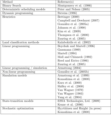
There are a number of complex methods for incor-porating wildfire into forest planning processes, such as the seminal work of Van Wagner (1979), who was one of the first to develop a simple model examining wildfire loss appraisals. This discussion follows a methodolog-ical rather than temporal framework, beginning with non-spatial classification and sorting of inventories, then leading to non-spatial operations research methods, and finally to methods that specifically account for spatial complexities of the landscape. Table 1 summarizes the approaches discussed along with references demonstrat-ing their ability to support forest management and plan-ning.
One of the more straightforward methods (Kal-abokidis et al. 2002) uses a land classification process to assess wildfire vulnerability. This model quantifies potential wildfire conditions through inventory methods and landscape analyses (GIS). With this model, planners would first estimate external environmental factors to determine the risk of a forest to wildfire. Then, internal factors to determine the productivity and resilience of the forest would be estimated. The two estimates would then be combined to rank the vulnerability of the land and to evaluate wildfire loss potential across a forest. As Kalabokidis et al. (2002) note, there are a number of problems with approaches such as these, which include: (a) some of the factors are qualitative, (b) some of the factors are measured using non-standard measurement units, and (c) incorporating these factors into a decision process may be difficult. In any event, Kalabokidis et al. (2002) suggest that one might estimate the relative weight of the factors influencing wildfire, rank these into ”danger classes,” and use a benefit / cost analysis to in-form decisions related to forest planning.
peri-Table 1: Fire modeling reference according to method employed.
Method Reference(s)
Binary Search Montgomery et al. (1986) Deterministic scheduling models Peter and Nelson (2005) Dynamic programming Stevens (1986)
Heuristics Bettinger (2009)
Campbell and Dewhurst (2007) Gonz´alez et al. (2005a)
Johnson et al. (1998) Kim et al. (2009) Thompson et al. (2000) Zuuring et al. (2005) Land classification methods Kalabokidis et al. (2002) Linear programming Boychuk and Martell (1996)
Gassmann (1989) Martell (1994)
Moll and Chinneck (1992) Reed and Errico (1986) Zuuring et al. (2005) Linear programming / simulation Armstrong (2004) Non-linear programming Gonz´alez et al. (2005b) Simulation models Armstrong et al. (1999)
Konoshima et al. (2008) Kurz et al. (2000) Shifley et al. (2000) Van Wagner (1979) Van Wagner (1983) Yang et al. (2004)
State-transition models ESSA Technologies, Ltd. (2009) Keane et al. (2006)
Stochastic optimization Hyyti¨ainen and Haight (in press) Konoshima et al. (2008)
ods. This was termed an ”iterative state updating pro-cedure,” and as we will see, processes such as these are used in other methods as well. Reed and Errico (1986) determined that a close approximation to an optimal solution for a forest plan can be developed using de-terministic wildfire distributions that closely resemble the stochastic disturbance levels, since over broad areas the variance in the proportion of land burned should be small. Other similar work in this area includes Moll and Chinneck (1992), who developed a linear programming model to examine the effects of both wildfire and insect outbreaks using average disturbance values for each. In this work, it was also determined that a deterministic method was a good enough approximation to solutions obtained using randomly generated wildfire and insect outbreak probabilities. Moll and Chinneck (1992) also used an iterative state updating process (linear
to other states, and the use of a limited number of man-agement regimes for burned areas (i.e., no salvage har-vests), both in order to keep the problem formulation to a reasonable size.
Gassmann (1989) developed a method to maximize timber harvest levels over a finite time horizon, while tracking areas and management actions using a Model II linear programming problem formulation. In general, some area in each age classes would be scheduled for harvest, then a random portion of the remaining area would be destroyed by a disturbance (assumed here to be a wildfire). The loss rates from wildfires could be deterministically or randomly chosen, and in the latter case were assumed to not be fixed proportion of each age class during each time period. As mentioned above, problems involving a deterministic proportion of distur-bance in each age class were first addressed using linear programming. When probabilities of wildfire loss were considered, in order to model stochastic proportions of disturbance, a special computer program based on the Dantzig-Wolfe decomposition principle was employed.
As planning methods evolved, Armstrong (2004) de-veloped an iterative procedure using linear program-ming and Monte Carlo simulation to integrate harvest scheduling and wildfire effects. In this procedure, areas burned by wildfire were randomly generated from a log-normal continuous distribution after linear programming was used to schedule activities and determine the allow-able cut. The areas assumed to be burned were therefore not a fixed proportion of the age classes during each time period, but allowed to vary within the confines of the lognormal distribution. These randomly burned areas were deducted from their previously forested strata and placed in a regeneration stratum. However, the wildfires were only assumed to occur after management activities were scheduled in a time period. Therefore, the forest inventory at the end of a time period was updated by passing the burned areas to the youngest forest age class. The model then moved to the next time period, and using the updated inventory, areas burned from wild-fire were again randomly generated from a lognormal continuous distribution. This sequential updating pro-cedure continued through the end of the time horizon. The entire process was repeated 1,000 times to generate probability distributions for allowable cut levels.
Armstrong et al. (1999) illustrate the use of area-volume check along with simulation methods to ar-rive at estimates of the amount of volume ”disturbed” across the landscape, and compare this natural dis-turbance regime against the sustainable harvest level. The method for incorporating wildfire into the planning process involved understanding the natural disturbance rates (e.g., areas burned annually) for the region in ques-tion (Alberta), and then re-directing an amount of land
equal to this area to a regeneration stratum each time period. The growth and condition of the forest is then re-assessed and future time periods are modeled. Arm-strong et al. (1999) suggested through this work that land managers should schedule timber harvests at a rate implied by the local natural disturbance model, although they acknowledge that the spatial elements of the land-scape are ignored completely.
Dynamic programming has frequently been used to address the stand-level optimization problems (e.g., Brodie et al., 1978; Brodie and Kao, 1979), and to a much lesser extent, the forest-level optimization prob-lem (Borges et al., 1999). However, in a Master’s thesis, Stevens (1986) described the development of a multi-objective problem that incorporated the value of timber harvest and a value to describe the smoothness of wood flows from the planned management activities under the risk of wildfire. The state variable used to describe the forest was the even-flow level that was determined by area-volume check (a proxy for the age-class distribu-tion of the forest at any point in time). State-transidistribu-tion matrices were then generated from a Monte Carlo sim-ulation model that recognized different harvest levels and wildfire regimes, the latter of which were based on lognormal distributions. Non-linear stand-level op-timization using the Hooke and Jeeves method has also been used to account for the risk of wildfire (Gonz´alez et al. 2005b). Here, wildfire probabilities, along with repeated simulations, were necessary to understand the effect of wildfire frequency on optimal economic manage-ment regimes forPinus sylvestris in Spain. Hyyti¨ainen and Haight (in press) examined the effect of wildfire risk on stand-level decisions using stochastic optimization in conjunction with a growth and yield model. Wildfire probabilities are employed and diameter distributions are adjusted (when wildfires are assumed to occur) in the development of optimal management regimes for conif-erous forests in Idaho.
in the youngest age class stratum. Another forest plan, using this burned forest age class structure was then de-veloped using binary search, and a comparisons of the two (burned and unburned) ensued. A comparison of the with, and without, assumptions of wildfire revealed trade-offs in the growth and harvest of individual age classes (strata) over time. Montgomery et al. (1986) suggested that applying this approach to different types of forests helps one understand how the impact of wild-fire on timber supplies can perhaps be significant.
State-transition models are generally non-spatial in nature, yet involve stochastic processes to evaluate al-ternative states of the landscape given uncertain rela-tionships between management activities, natural dis-turbances, and forest transition. VDDT (Vegetation Disturbance Dynamics Tool, ESSA Technologies, Ltd., 2009) has been widely used of late to assist in the devel-opment of U.S. National Forest plans. VDDT was ini-tially developed for the Interior Columbia River Basin Project (Haynes and Quigley, 2001), and represents a non-spatial state-transition model that incorporates disturbance probabilities and successional pathways to project landscapes into the future. A spatial version of this model has also been developed (TELSA, to be described later). Within VDDT, pathway diagrams for forest and rangeland vegetation complexes are developed using the following: expert opinion, disturbance proba-bilities, and impacts of disturbances and management actions on stand structure and composition. Given the stochastic transition probabilities, multiple simulations of VDDT help one understand the potential trajectory (and inherent variability) of a forest managed under a given set of operational assumptions, and subject to a certain suite of natural disturbance regimes.
Spatial simulation models expand on the set of tools available to assess the impacts of wildfire on forest plans. Van Wagner (1979) was one of the first to develop a sim-ple model examining wildfire loss appraisals. Using a net present value approach, the focus of this work was on a regulated forest assigned to a grid of ”units” that were all of equal size. The process begins with a determin-istic selection of the units within which wildfires dam-age the timber resources, which occurs at the beginning of the simulation. These affected forested stands are assigned the youngest age class, and regeneration is as-sumed to have occurred. Harvests are then scheduled for the entire time horizon using a rule of scheduling oldest age classes first. With this work, Van Wagner (1979) showed how the impact of wildfire can influence the net present value of the entire forest, particularly when dis-count rates and growth rates vary. Basically, substi-tutions for what would have been the next scheduled harvest units are made, after assuming some of these areas were destroyed from wildfire and subsequently
re-generated. Van Wagner (1983) later expanded on this approach, and again focused on a regulated forest as-signed to a grid of ”units” that are all of equal size. In this second approach, a random selection is made of the units within which wildfires damage the timber re-sources. The affected stands are assigned the youngest age class, and regeneration is assumed to have occurred. Although stands are randomly selected, the rate of wild-fire disturbance is fixed. After wildwild-fires have assumed to occurred, harvests are scheduled for other units at a pre-defined percentage cut per year, using a ”highest vol-ume” first approach. Through this simulation approach, given the percent of harvest allowed and the percentage of area burned, annual harvest levels could be simulated. In terms of more sophisticated landscape simulation models, the LANDIS model (Yang et al., 2004) takes a grid-based modeling approach to management actions and natural disturbances across broad landscapes. The size, frequency, and intensity of wildfires can be sim-ulated in LANDIS using probability distributions, and these simulated disturbances remove land from older for-est age classes and place it in a recently regenerated age class. To accomplish this task, the sites to be dis-turbed are selected randomly, a disturbance intensity is drawn from a probability distribution, and tree co-horts are removed from age classes within the areas dis-turbed. These initially are considered ”ignitions” rather than wildfires that spread across the landscape. How-ever, if an ignition becomes an initiated wildfire, it is grown (spread) up to a pre-determined size drawn from a size distribution. Shifley et al. (2000) also describe an application of LANDIS to simulate the effects of wild-fire and windthrow disturbances in a forest plan; in this case the setting was the Missouri Ozarks in the central region of the United States. Ignition frequencies and wildfire return intervals were also involved to simulate disturbance events that affect age classes of forests.
restric-tions. A routine is then called that determines the areas that are burned. Decision rules are then used to de-termine whether to salvage or naturally regenerate the burned areas. The process is then repeated for the re-maining time periods in the time horizon, and an assess-ment is performed to determine whether a sustainable harvest level has been achieved. Peter and Nelson (2005) suggest that multiple runs of the model may be neces-sary to understand the range of sustainable harvest lev-els with a given disturbance regime, and to understand the probability of harvest shortages within a range of harvest levels and wildfire suppression scenarios.
Another vector-based simulation model is the LAND-SUM (LANDscape SUccession Model, version 4.0) model with is described as a spatial, state-transition model that operates at the stand level (Keane et al., 2006). In contrast to the FPS-ATLAS model, LAND-SUM includes a spatially-explicit wildfire spread model, which operates at the pixel level within stands. Wild-fires are then spread using directional vectors of wind and slope. Disturbance initiations are modeled stochas-tically, and effects are based on current vegetation condi-tions. Three wildfire approaches can be used: maximum wildfire sizes, ellipses, and cellular automata approaches. If stands are partially burned, the burned and unburned portions are assigned different successional classes and stand ages. The LANDSUM model can work in conjunc-tion with VDDT to determine successional pathways, and human-induced disturbances (harvests) can also be modeled stochastically.
TELSA (Tool for Exploratory Landscape Scenario Analyses) is a spatially-explicit simulation model (Kurz et al., 2000) that requires stand polygons, streams, wet-lands, lakes, and transition probabilities (from VDDT). TELSA is integrated with geographic information sys-tems, and the disturbances are modeled by polygon. Adjacency and activity limits can be controlled, just as they can be in FPS-ATLAS. During the planning pro-cess, natural succession is simulated, using the state-transition model VDDT (described earlier) in the first time period. Then natural disturbances are simulated in the stand polygons, up to a user-defined limit per year and size, thus disturbances can be spread to eligi-ble neighboring polygons. Salvage logging is then simu-lated, and management activities are assigned to stands deterministically from a sorted list of stands. Manage-ment activities are scheduled until the activity limit for the time period in question has been reached, or until there are no more eligible management units in which to schedule activities. The process is repeated for all other time periods in the time horizon. Multiple runs of scenarios are encouraged to assess the range of variabil-ity that may be suggested in future representations of the landscape. However, if natural disturbances are not
assumed in the model, it reduces to a deterministic har-vest scheduling process. Strand et al. (2009) describe an application of TELSA to aspen (Populus tremuloides) forests of the intermountain region of the United States, and Provencher et al. (2007) describe an application of TELSA to public lands in Nevada, where livestock graz-ing, forest management, and natural disturbances are all taken into account.
Heuristic models have also been used to incorporate wildfire processes into forest planning process. Camp-bell and Dewhurst (2007) modeled the temporal pattern and process of wildfire disturbance through traditional harvest scheduling methods. In this work a simulated annealing heuristic was used to schedule harvests, and the objective function was designed as a goal program-ming problem. The goals were developed to minimize deviations from desired landscape conditions. This plan-ning process also requires vector data (stand polygons, etc.). As with harvests, disturbances are modeled by polygon, and are randomly located regardless of stand age. The chance of a natural disturbance is based on wildfire probabilities, and the intent was to make in-ferences of the impact of the frequency of disturbance on timber supply. Thus the temporal pattern of dis-turbance is modeled as a harvest from historical evi-dence of the frequency of wildfires in the area studied (British Columbia). This planning process does not di-rectly model the disturbances (i.e., harvests are used as a proxy for wildfires), and targets regarding the size and configuration of wildfires were noted as future directions for the work.
Gonz´alez et al. (2005a) used both tabu search and the Hero model (Pukkala and Kangas 1993) to locate near-optimal landscape-level plans that incorporated land-scape metrics and wildfire risk. In this work, wildfire was spread spatially across the landscape using wildfire strike probabilities and probabilities related to the spread of wildfire to adjacent forested stands. Each stand was as-signed a resistance index that was related to the stand conditions, and through repeated landscape-level simu-lations, the mean burned area of the landscape was used to describe the overall resistance to wildfire. Thompson et al. (2000) also used tabu search to maximize economic objectives subject to wood flow and harvest adjacency constraints. This work also involved minimizing wildfire hazard ratings, since it was assumed that the average area burned was proportional to areas which were rated as having high or extreme wildfire hazard. In contrast to other work, wildfire spread was not explicitly modeled in this approach.
harvests and fuel treatments. The goal of this planning process was to find ways to reduce the potential for high severity wildfires with management actions. Elevation, slope, aspect, custom fuel models, and the BEHAVE model (Burgan and Rothermel, 1984) were used to es-timate the potential damage for each vegetation class based on flame length. Given the objectives and con-straints of the problem, wildfires were generated for all time periods from a probability distribution (amount, size, location), up to an average amount of wildfire over a given period of time. Selected polygons were burned based on their wildfire risk factor and the likely wind direction, and the wildfires were spread up to the de-sired size. After wildfires were simulated, the system used rules to decide whether to salvage stands immedi-ately or to post-pone harvests. Sessions et al. (1999) expanded on this and developed a process where effects of fuel breaks could be modeled within the context of wildfire and forest transition. Here, a spatially explicit simulation / optimization model that included a forest stand dynamics model, a stand management optimizer for dynamically selecting prescriptions at run time (i.e., not-prescheduled prescriptions), and a spatially explicit wildfire spread model (FARSITE, Finney, 1998) were incorporated into a heuristic technique. This planning process facilitated the scheduling of management activi-ties, the simulation of wildfire, and the associated growth and mortality of vegetation, all of which were guided by stand-level and landscape-level objectives.
Konoshima et al. (2008) incorporate a spatial wildfire spread model into a stochastic optimization process to evaluate optimal patterns of fuel management activities across the landscape. Another process for scheduling forest management activities in a spatial pattern (dis-persed, clumped, random, and regular) across the land-scape, in an attempt to mitigate the impacts of wildfire, is presented in Kim et al. (2009). Here, a heuristic (the great deluge algorithm) was developed to schedule man-agement activities, both operational and those aimed at fuel reduction, and wildfires are simulated using FAR-SITE methods. In this work, fifteen randomly located ignitions were placed on the landscape after management activities were scheduled, and the impact on wildfire behavior and scheduled timber harvest volume was as-sessed. One limitation of the Kim et al. (2009) work was that wildfires were only simulated after the first time pe-riod in the time horizon, given the computer processing requirements. Bettinger (2009) extended this work using a feed-back mechanism for stochastic processes that was incorporated into the development of a forest plan. The heuristic in this effort was a combination of 1-opt and 2-opt tabu search, and again wildfire was simulated using FARSITE code. Non-complete mortality was assumed, based on fire line intensity. These two processes
be-gin with the development of a set of optimal stand-level management prescriptions, which are assigned to timber stands to generate an initial plan of action that leads to the highest, and most even scheduled timber volume. In the second effort, the spatial location of wildfires are then simulated period-by-period using FARSITE code. The number of wildfires per period was fixed, yet the location of ignition was random. Further, timber stands that are affected by wildfire are re-assigned management prescriptions based on their resulting vegetative condi-tion, using a burn severity rating (i.e., stands were not necessarily redirected to a regenerated forest structure). The scheduled wood volume is then re-evaluated from the period in question forward through the time hori-zon.
Finally, the MAGIS (Multi-resource Analysis and GIS) model (Zuuring et al., 2005) was developed by the U.S. Forest Service and the University of Montana. This spatial harvest scheduling model develops a treatment schedule based on the hazard ratings from SIMPPLLE (Simulating Patterns and Processes at Landscape LEv-els), the treatment locations from TOM (Treatment Op-timization Model), and the potential wildfire behavior from MTT (Minimum Travel Time), along with other socio-economic goals. MAGIS is integrated with geo-graphic information systems, and linear programming, mixed integer programming, or heuristic methods are available for optimizing management actions. Tactical, long-range planning is facilitated, and treatments ac-count for disturbance processes such as wildfire. Using SIMPPLLE and MAGIS in an iterative manner can al-low one to plan the optimal size and location of forest treatments that are most effective in reducing the size of wildfires. MAGIS is one of the few decision-support models that is currently publicly available and supported by the developers.
4
Discussion
the climate generally more humid. One of the main con-clusions of several of the works presented in this paper is that a buffer stock of forests should be maintained in each age class to counteract the probability of losing some of these areas to wildfire each year. How wildfires have been incorporated into and accounted for in for-est planning models is interfor-esting as well, and tends to follow the evolution and development of computers, op-erations research techniques, and mapping systems. The earlier models simply reduced strata (bins of acres) by either a deterministic or random amount, then seek to re-define allowable harvest levels. In later models, vec-tor polygons, which are commonly used in tactical forest planing models, have been used to represent the spatial location of wildfires, although grid-based approaches are perhaps the most realistic (yet most complex as well).
The variety of operations research approaches that have been used generally reflect the state of the art in this area at the time that the work was developed. Some researchers opted for relatively simple representations of wildfire effects to match the requirements of the oper-ations research technique used, although it seems that advances in operations research have been prompted by the desire to accommodate wildfire effects. It is also pos-sible that some of the relatively simple approaches have been opted for given the stochastic nature of wildfires and the resulting uncertainties regarding ignition loca-tion, wildfire intensity, and wildfire behavior. Boychuk and Martell (1996) noted a number of limitations of lin-ear programming models, each made with the intent of maintaining a small model size. With advances in com-puter technology and optimization software, these issues may not be as important today. Simulation models and heuristics can be designed to accommodate a wide vari-ety of functional relationships among disturbances, land-scape conditions, and forest goals. However, these mod-els can become too complex for land managers to use in practice.
There are a number of differences in the models de-scribed here that reflect the evolution of computer mod-eling and our knowledge of wildfire behavioral processes. First, the impact of wildfires are accounted for in the various planning processes in a variety of ways, from strata reductions, to pixel-based growth and assessment of wildfires, to vector-based polygon impacts and the spread of wildfire from one polygon to other adjacent polygons. Second, the frequency, intensity, and spread of wildfires have been both deterministically and ran-domly assumed. When ranran-domly estimated, either sta-tistical distributions are used to estimate intensity and frequency, or a wildfire spread model is employed to let wildfires burn across the landscape. Finally, when wild-fires are assumed to occur, they are either incorporated into a planning process before harvests and other
activ-ities are scheduled, or after harvests and other activactiv-ities are scheduled. Given the length of some of the time pe-riods (perhaps a decade or longer), one area of research seems to be to find ways to simultaneously schedule har-vests and other activities along with wildfires.
5
Conclusions
Drawing conclusions about the impact of wildfires on outputs desired from forest plans has prompted plan-ners to find ways to creatively account for these natural disturbances along with proposed management activi-ties in planning models. The depth and scope of this integration is partly a function of the educated ability of the planner to address these concerns, partly a func-tion of the technology and data available, and partly a function of the time and effort that is allocated to the effort. The difficulty in incorporating wildfires into for-est plans is that no one knows when and where they will occur, and to what extent wildfires will affect natural resources. Probability distributions or rates of distur-bances are adequate proxies for modeling these events, yet given the uncertainties involved, numerous simula-tions may be necessary, as some has proposed, to gain an understanding of what might happen to timber sup-plies and other services over time. For this reason, oth-ers have suggested that deterministic rates of damage may be just as appropriate as more refined and complex models for estimating the impacts. Perhaps due to the evolution of science and technology (functional relation-ships among resources, computers, operations research techniques, other software) or perhaps due to the fact that researchers can only publish novel work, there has been an obvious evolution in the methods that can be employed to integrate wildfire into forest planning pro-cesses. These advances, however, may exceed the current ability of planners to implement the processes, and thus recent advances may only be of value to research organi-zations that support landscape planning efforts. In any event, there are a few avenues of research still open, and time will tell how valuable recent (and future) develop-ments will be to society in general.
Acknowledgements
We appreciate the thoughful comments of the anony-mous reviewers of the manuscript.
References
Armstrong, G.W. 2004. Sustainability of timber supply considering the risk of wildfire. Forest Science. 50: 626-639.
Adamow-icz. 1999. Timber supply implications of natural disturbance management. The Forestry Chronicle. 75(3): 497-504.
Bettinger, P. 2009. A prototype method for integrating spatially-referenced wildfires into a tactical forest planning model. Research Journal of Forestry. 3: 8-22.
Bettinger, P., and W. Chung. 2004. The key literature of, and trends in, forest-level management planning in North America, 1950-2001. The International Forestry Review. 6: 40-50.
Bettinger, P., K. Boston, J.P. Siry, and D.L. Grebner. 2009. Forest management and planning. Academic Press, New York. 331 p.
Borges, J.G., H.M. Hoganson, and D.W. Rose. 1999. Combining a decomposition strategy with dynamic programming to solve spatially constrained forest management scheduling problems. Forest Science. 45: 201-212.
Boychuk, D., and D.L. Martell. 1996. A multi-stage stochastic programming model for sustainable forest-level timber supply under risk of fire. Forest Science. 42: 10-26.
Brodie, J.D., D. Adams, and C. Kao. 1978. Analysis of economic impacts on thinning and rotation for Douglas-fir, using dynamic programming. Forest Science. 24: 513-522.
Brodie, J.D., and C. Kao. 1979. Optimizing thin-ning in Douglas-fir with three-descriptor dynamic programming to account for accelerated diameter growth. Forest Science. 25: 665-672.
Burgan, R.E., and R.C. Rothermel. 1984. BEHAVE: Fire behavior prediction and fuel modeling system – FUEL subsystem. USDA Forest Service, Inter-mountain Forest and Range Experiment Station, Ogden, UT. General Technical Report INT-167. 126 p.
Butry, D.T., D.E. Mercer, J.P. Prestemon, J.M. Pye, and T.P. Holmes. 2001. What is the price of catas-trophic wildfire? Journal of Forestry. 99(11): 9-17.
Campbell, K.A., and S.M. Dewhurst. 2007. A hierar-chical simulation-through-optimization approach to forest disturbance modelling. Ecological Modelling. 202: 281-296.
Centers for Water and Wildland Resources. 1996. Sta-tus of the Sierra Nevada, Summary of the Sierra Nevada Ecosystem Project Report. University of
California, Davis. Wildland Resources Center Re-port No. 39.
ESSA Technologies, Ltd. 2009. Vegeta-tion Dynamics Development Tool (VDDT). ESSA Technologies Ltd., Vancouver, BC. (www.essa.com/forestry/vddt). Accessed June 25, 2009.
Finney, M.A. 1998. FARSITE: Fire Area Simulator – model development and evaluation. USDA For-est Service, Rocky Mountain Research Station, Ft. Collins, CO. Research Paper RMRS-RP-4.
Gassmann, H.I. 1989. Optimal harvest of a forest in the presence of uncertainty. Canadian Journal of Forest Research. 19: 1267-1274.
Gonz´alez, J.R., M. Palah´ı, and T. Pukkala. 2005a. In-tegrating fire risk considerations in forest manage-ment planning in Spain - a landscape level perspec-tive. Landscape Ecology. 20: 957-970.
Gonz´alez, J.R., T. Pukkala, and M. Palah´ı. 2005b. Optimising the management ofPinus sylvestris L. stand under risk of fire in Catalonia (north-east of Spain). Annals of Forest Science. 62: 493-501.
Haynes, R.W, and T.M. Quigley. 2001. Broad-scale consequences of land management: Columbia basin example. Forest Ecology and Management. 153: 179-188.
Hyyti¨ainen, K., and R.G. Haight. (in press). Evalu-ation of forest management systems under risk of fire. European Journal of Forest Research.
Johnson, K.N., J. Sessions, J. Franklin, and J. Gabriel. 1998. Integrating wildfire into strategic planning for Sierra Nevada forests. Journal of Forestry. 96(1): 42-49.
Kalabokidis, K.D., S. Gatzojannis, and S. Galatsidas. 2002. Introducing wildfire into forest management planning: Towards a conceptual approach. Forest Ecology and Management. 158: 41-50.
Keane, R.E., L.M. Holsinger, and S.D. Pratt. 2006. Simulating historical landscape dynamics using the landscape fire succession model LANDSUM version 4.0. USDA Forest Service, Rocky Mountain Re-search Station, Ft. Collins, CO. General Technical Report RMRS-GTR-171CD. 73 p.
Konoshima, M., C.A. Montgomery, H.J. Albers, and J.L. Arthur. 2008. Spatial-endogenous fire risk and efficient fuel management and timber harvest. Land Economics. 84: 449-468.
Kurz, W.A., S.J. Beukema, W. Klenner, J.A. Gree-nough, D.C.E. Robinson, A.D. Sharpe, and T.M. Webb. 2000. TELSA: The Tool for Exploratory Landscape Scenario Analyses. Computers and Elec-tronics in Agriculture. 27: 227-242.
Martell, D.L. 1994. The impact of fire on timber supply in Ontario. The Forestry Chronicle. 70: 164-173.
Moll, R.H.H., and J.W. Chinneck. 1992. Modeling re-generation and pest control alternatives for a forest system in the presence of fire risk. Natural Resource Modeling. 6: 23-49.
Montgomery, C.A., J.D. Brodie, and D.A. Cleaves. 1986. Allowable cut effect and fire-damage ap-praisal. Western Journal of Applied Forestry. 1: 100-103.
Peter, B., and J. Nelson. 2005. Estimating harvest schedules and profitability under the risk of fire dis-turbance. Canadian Journal of Forest Research. 35: 1378-1388.
Provencher, L., T.A. Forbis, L. Frid, and G. Medlyn. 2007. Comparing alternative management strate-gies of fire, grazing, and weed control using spatial modeling. Ecological Modelling. 209: 249-263.
Pukkala, T., and J. Kangas. 1993. A heuristic opti-mization method for forest planning and decision making. Scandinavian Journal of Forest Research. 8: 560-570.
Reed, W.J., and D. Errico. 1986. Optimal harvest scheduling at the forest level in the presence of the risk of fire. Canadian Journal of Forest Research. 16: 266-278.
Sessions, J., K.N. Johnson, J. Franklin, and J. Gabriel. 1999. Achieving sustainable forest structures on
fire-prone landscapes while pursuing multiple goals.
In Spatial Modeling of Forest Landscapes, D. Mladenoff and W. Baker (eds.). Cambridge Uni-versity Press.
Shifley, S.R., F.R. Thompson III, D.R. Larsen, and W.D. Dijak. 2000. Modeling forest landscape change in the Missouri Ozarks under alternative management practices. Computers and Electronics in Agriculture. 27: 7-24.
Stevens, N.S. 1986. Optimal harvest rates considering the risk of forest fire. M.Sc. Thesis, Department of Forest Science, University of Alberta, Edmonton. 132 p.
Strand, E.K., L.A. Vierling, and S.C. Bunting. 2009. A spatially explicit model to predict future land-scape composition of aspen woodlands under var-ious management scenarios. Ecological Modelling. 220: 175-191.
Thompson, W.A., I. Vertinsky, H. Schreier, and B.A. Blackwell. 2000. Using forest fire modelling in mul-tiple use forest management planning. Forest Ecol-ogy and Management. 134: 163-176.
Van Wagner, C.E. 1979. The economic impact of in-dividual fires on the whole forest. The Forestry Chronicle. 55(2): 47-50.
Van Wagner, C.E. 1983. Simulating the effect of forest fire on long-term annual timber supply. Canadian Journal of Forest Research. 13: 451-457.
Yang, J., H.S. He, and E.J. Gustafson. 2004. A hi-erarchical fire frequency model to simulate tempo-ral patterns of fire regimes in LANDIS. Ecological Modelling. 180: 119-133.