INTRODUCTION
Dynamic development of the weather on Earth in the recent period has been characterized by the onset of extreme situations resulting in floods. As a result of torrential rains that may cause spilling the river water from the river bed, or may flood lowland areas due to surface runoff from the sur -rounding area. The result of these phenomena is areas flooded with water. The overflow time can be diametrically different. In case of shedding the dykes, water from flooded areas gradually returns to the riverbed. Return of water to the river de -pends on the existence of the system of drainage of internal waters. Surface water is concentrated
in the drainage channels and via their networks it gets to the recipient and allows the entry to the previously flooded land. The functional drainage systems are able to provide draining of excess water in the course of 2–3 weeks, as required by the technical Standard to ensure water drainage [Ministry of Environment 2011].
Evaluation of the functioning of drainage tems currently provides the remote sensing sys-tem that can provide information about spatial and time course of flooded areas. The paper deals with the evaluation of satellite images from the period of extraordinary flooding in the area of Brodog Hornád in 2010 [Holičová 2013, WFD 2007/60 EU 2011, Ministry of Environment 2011].
CULTURAL LANDSCAPE, FLOODS AND REMOTE SENSING
Dušan Húska1, Ľuboš Jurík2, Lucia Tátošová3, Karol Šinka3, Johana Jakabovičová4
1 Faculty of European Studies and Regional Development, Department of Regional Bioenergetics, Slovak University of Agriculture in Nitra, Trieda Andreja Hlinku 2, 94976 Nitra, Slovakia, e-mail: dusanhuska@ gmail.com
2 Faculty of Horticulture and Landscape Enegineering. Department of Water Resources and Environmental Engineering, Slovak University of Agriculture in Nitra, Trieda Andreja Hlinku 2, 94976 Nitra, Slovakia 3 Faculty of Horticulture and Landscape Enegineering. Department of Landscape Planning and Land
Consolidation, Slovak University of Agriculture in Nitra, Trieda Andreja Hlinku 2, 94976 Nitra, Slovakia 4 Faculty of Economics, Department of Languages, Slovak University of Agriculture in Nitra, Trieda Andreja
Hlinku 2, 94976 Nitra, Slovakia
Volume 18, Issue 3, May 2017, pages 31–36
DOI: 10.12911/22998993/69348 Research Article
ABSTRACT
The dynamics of the cultural landscape is associated with the penetration of people into the natural landscape, the settling and adaptation to the needs of the society and its devel-opment. Climate creates the decisive influence, specifically the form of extremely high rainfall causing flooding. Adverse impact on the cultural agricultural landscape is mainly the submersion time. This time depends on the configuration of the terrain, its disposition and the existing drainage ditches in the area, ensuring the drainage of the flood to the recipients. Long-lasting floods have stipulated taking measures for the protection of the area from flooding by building dikes and drainage of the flood from the area. Identify-ing the extent of extreme floods and zones of permanent waterloggIdentify-ing is currently pro-vided by modern technology which allows recording satellite images in different spectral bands. Within the basic distinguishing signs mainly accruing is used and it is possible to track changes of the extent of flooded areas and thus identify problem areas insufficiently protected against long-term flooding. Consequently, it is possible to solve the concept of exploiting such areas to keep them in the structure of PPF or their reclassification in wetland systems with necessary legislative security. The aim of this paper is to show the possibility of using satellite images in identifying the extent of flooding.
Keywords: drainage, flood, landscape, river, satellite Received: 2017.02.16
Journal of Ecological Engineering Vol. 18(3), 2017
METHODOLOGY
Conditions for draining excess water from the territory were determined by the technical Stan -dards for draining agricultural land. Drainage sys -tems have to create conditions for ensuring the cor-rect functioning of the water regime. Management of drainage system was under the jurisdiction of the State Land Drainage System Administration and land drainage cooperatives or Water Manage -ment Enterprises. Their competence is monitoring, maintenance and repairing of drainage systems.
Currently, there are prevailing views about the harmfulness of drainage systems and in gen-eral it is argued that the drainage systems cause drying of soil. In compliance with the technical Standards,regulation of the water regime was op-timal and secured mainly draining of the excess water causing waterlogging of agricultural land. It should be realized that the cultural landscape was created primarily to support human development, exploit the country to the benefit of the population as well as to provide necessary food resources. Regulation of soil water regime in the plains was carried out by maintaining the water level in the drainage systems with the help of pumping sta-tions. In case of floods or excess water they had to drain the water into recipients [Holičová 2013].
Today we have modern methods to monitor the extent of flooded areas using remote sensing. In practice, the CORINA system is commonly used and allows you to track the way how land resources are used. Remote sensing also provides more possibilities for evaluating the coverage of the surface under different conditions. Particu -larly, monitoring the water coverage area by re-cording the reflection of the land surface in the zone outside the visible spectrum is preferred, especially in the zone of infrared radiation. In -frared radiation is largely absorbed by water and thus reflection of surface covered with water is close to zero.
A new approach for solving complex flood protection and securing the environment for peo-ple represents Magdalini [Magdalini 2015] in the assessment of water management in the Nether -lands. The principle should solve the dilemma, “What do we have to sacrifice first? Environment? economy? or people? This question was already answered by our ancestors, when they began to solve the protection of persons and their property. Even today, we must seek a comprehensive solu-tion [WFD 2007/60 2011, Ministry of Environ -ment 2011, Ministry of Agriculture 2011].
RESULTS
In the period from 1950 to 1985 the Eastern Slovak Lowland (VSN) was protected against the long-term soaking by water drainage systems, covering the total area of 480 000 hectares (20% PPF). The drainage system consisted of system -atic tube drainage, outfall drains into waterways gravity and in parts of the area with a small slope drains were built with pumping stations, permit-ting penetration of water from the flood even in case of high water level in the stream. These systems included 6282 km of canal network, 41 pumping stations, 458 000 hectares of system -atic drainage and 491 gas stations. Over the last 25 years there was not significant concern about these systems and their functionality. Based on the survey in 1999 [Húska and Jurík 2000, Ka -bina and Jurík 1999] much of the drains were clogged with suspended load and overgrown with aquatic plants and grass. Runoff drains were broken, drainage outlets destroyed and drainage shafts buried with garbage [Annual Report 2011]
According to a survey of the Technical Uni -versity in Zvolen [Technical uni-versity Zvolen 2011], the situation of the water management fa-cilities can be compared by looking at the aerial photographs of the territory in 1950.
In Figure 1 you can see extensive wetlands in the area of the current Šírava water reservoir.
VSN is an area made up mostly of heavy soils with a very low coefficient of filtration. VSN is a large flat area where the altitude is around 100 to 150 meters above the sea level. VSN is inter -woven with many rivers. The most important are Ondava, Topľa, Laborec and Latorica which flow near the border with Hungary into the river Bo -drog. VSN climate is warm. In winter months the temperature falls down between -2 to -4 °C, in the summer months between 17–20 °C on average. The number of days with snow cover ranges from 50 to 70 and the number of summer days is 50 to 70 [https://sk.wikipedia.org/].
streams in the border region, especially by flood -ing of adjacent areas of flows on the Slovak side. In the past this area was mainly the marshes and wetlands with their adverse effects on the en -vironment. Drainage systems improved the con -ditions of life of people but reduced the retention capacity for water in that area. Currently, revital -ization and restoration of wetlands and marshes could be considered but the major problem is land ownership. Revitalization of the former country would require resolving the question of finan -cial compensation to landowners in response to
changes in agricultural land use for permanent or temporary grassland and lakes.
It would be appropriate to use information on the achieved production in the affected area and if the owner would agree with the change of use, the difference between the yields would be the subject of compensation for the reduction in the potential yield on the ground. In the long term the economic losses were outweighed by losses from flood risks. The government should accede to such a solution, which would contrib-ute to the overall positive hydrological balance of Slovakia.
Aatellite images of Landsat show the conse -quences of floods in May 2010 where you can see the flooded areas along streams in the VSN.
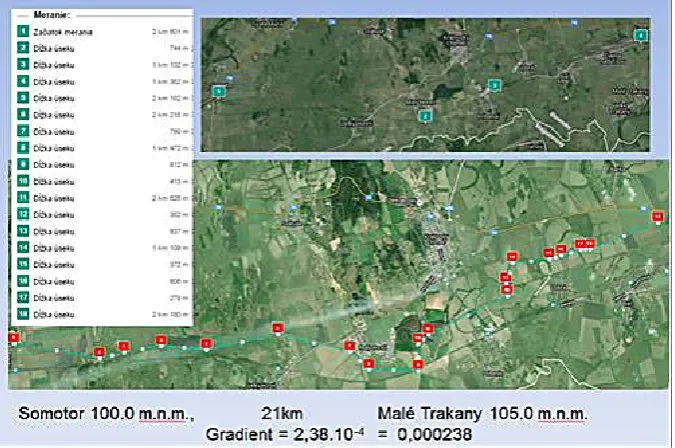
The biggest problem with runoff is in the southern part of the VSN, which is drained by the channel Somotor (Fig. 3). The channel diverts water from the large flat area, which has a slight slope from the east to the west. At the channel length of 21 km the altitude difference is only 5 m. Therefore, the slope of the area is only 0.000238. Particularly problematic is the flow profile that is largely overgrown and clogged with sediments floated from the surrounding land. Channeling water at high water levels in the river provide drainage pumping stations which, however, have little activity since the pump capacity exceeds the Figure 1. Aerial photos of the VSN area in 1950 and 2010 [http://mapy.tuzvo.sk/HOFM]
Journal of Ecological Engineering Vol. 18(3), 2017
potential flow of water through the channel, and flow-channel area is not able to transport such amounts of water to which the filling station is designed. [Kotorová, Kováč 2013].
The situation is similar in Western Slovakia in the river basin of Žitava (Figs. 4 and 5).
In the late May and early June in 2010 abun -dant rainfall in the basin Žitava caused the out -pouring of water from the stream channel, and a flow of Q1000 was recorded. The attached photos show the flooded area near the village of Maňa [Flood 2010].
Floods at that time did not have tragic conse -quences in terms of human victims. However, the impact lasted for a long period of time. In Slova -kia, neglecting regular maintenance of drainage network resulted in a slow return of water from the flooded area to the water flows. Long lasting flooded areas cause irreversible damage to veg -etation, damage of soil structure and reproduction of mosquitoes. Discussing a comprehensive ap -proach in addressing the issues of regulation of soil water regime all these factors must be tak-en into consideration. There are several options to solve the problem. Complete reconstruction and repair of existing drainage systems that en-sure agricultural production or in the territories critically threatened by flooding change the form of land resources exploitation by converting them into bodies of water or use a combination of both approaches.
The extent of flooded areas and a gradual decline of flooded areas can be monitored by us
-ing satellite imagery in particular in the infrared range or on the radar picture. The areas that are waterlogged in the long term could be used to build polders – polders are already known in the VSN (polder Beša). In case of threat of high wa -ter level to the area it would be possible to use these polders for water storage by transferring it to the reception area through drainage channels, thus avoiding damage to dykes when they spill through the flood wave. Retrospective satellite images could determine critical water levels in the floods. The floodgates would open and the water would gradually spill on adjacent areas.
Flood condition, including the protection of the territory requires detailed monitoring. In this context it is possible to use extensive benefits of remote sensing where we start from the resolution of satellite images. In this respect we consider the following forms of resolutions:
• Spectral resolution is defined in the range of wavelengths (the electromagnetic spectrum) and the number of intervals of the sensor (VIS, IR, NIR, radar)
• Geometric resolution refers to the ability of the satellite sensor to effectively record part of the Earth´s surface within a pixel (30x30 m Landsat, MODIS 1x1 km, 250x250 m)
• Radiometric resolution is defined as the ability of the imaging system to record many levels of brightness (the number of shades of gray) usu -ally used record 8-bit (0–255), 11-bit (0–2047), 12-bit (0–4095) or 16-bit (0–65535).
• Time resolution is defined by the time inter -val (for example, days), which will take place between the period of the image surface at a particular location [Mateeul et al. 2012].
Thus, we can choose a suitable distinctive feature and record it retrospectively especially regarding time changes. To select the appropri -ate image, we can use a web browser that pro-vides various show times of satellite images of any area on Earth. Suitability for image analysis of satellite imagery areas called “image hunter, Apollo mapping [Satellite images 2016]” can be opened via websites.
On the basis of the monitoring period it is possible to determine the areas that are not ad-equately protected in terms of draining excessive water, on the basis of which it would be possible to decide on a possible change of land use.
CONCLUSIONS
Floods occur due to the extreme weather events and especially due to the high amount of rainfall in a short period of time resulting in lon-ger periods of flooding of lowland areas in south -ern Slovakia. Critically flooded areas can be iden -Figure 4. Flooded agricultural land in the region Zlaté Moravce with the water level 310 and 400 cm
(Simulation) [Zorád 2010].
Journal of Ecological Engineering Vol. 18(3), 2017
tified by using satellite imagery. Such a change of land use would require registering the position of the territory in the cadaster PPF. It would be necessary to resolve the legislative issues related to ownership of the parcel of land and the sub-sequent legislative process of owners compensa-tion for the change of land use in accordance with social interests. Such measures could be carried out in compliance with the European Water Di -rective, which aims to achieve a better status of water bodies. Basic methods to identify areas that could be included in the draft amendments of PPF use are as follows:
• Monitoring the progressive reduction of the water level in the flooded areas by satellite. • Monitoring the functionality of drainage
sys-tems in the flooded area,
• Proposed reconstruction system for the regu-lation of water regime in flooded areas • Design and construction of new regulatory
el-ements (buildings) needed to ensure the soil water regime using the polders or permanent wetlands.
• Implementation of the measures proposed.
Acknowledgements
The article was elaborated with the support of the project “Anthropogenic impact on the pro -duction and quality of surface runoff from small watersheds in the conditions of climate change”, from the Grant Agency VEGA 1/0949/11 in pro -gram “Creation and quality of surface runoff from small watersheds in the conditions of cli-mate change”.
REFERENCES
1. Annual Report 2011: Annual Report 2010, Region-al EnvironmentRegion-al Office Košice
2. Basso B., Cammarano D., De Vita P., 2004: Re-motely sensed vegetation indices: Theory and Ap-plications for crop management. Rivista Italiana di Agrometeorologie 36–53 (1).
3. Blaas G., Bielek P., Božík M., 2010: Soil and agri-culture. Reflections on the future. Research Institute of Soil Science and Conservation, Bratislava, pp. 40. 4. Flood 2010, Žitava River.
https://youtu.be/sMRiL-pqh18I
5. Holičová M., 2013: Proposal of the local territorial system of ecological stability of the territory for the purposes of the Agricultural Paying Agency.
6. Húska D., Jurik L., 2000: Current problems of water management in the Eastern lowlands. Water management on Eastern lowlands, p. 120A, No. 1/ 200, District Environmental Office Michalovce. 7. https://sk.wikipedia.org/wiki/V%C3%BDchodosl
ovensk%C3%A1_n%C3%AD%C5%BEina 8. Jurik L., 2013: Water building. 2. ed. Nitra:
Slo-vak University of Agriculture, pp. 196. ISBN 978–80–552–0963–0.
9. Kabina P., Jurík Ľ., 1999: Perspective of drainage structures on the Eastern plains. In Proceedings: Land reclamation and water management at the turn of the millennium. Brno: Mendel University of Agriculture and Forestry, 129–133.
10. Kotorová D, Kováč, L., 2013: soil characteristics in the dry polder Besa. FOLIA GEOGRAPHICA Prešov 22.
11. Mateeul H. Memon A., M. Sher, M. Siddiqi, Jil-lani R., 2012: Techniques of Remote Sensing and GIS for Flood monitoring and damage assessment: A Case Study of Sindh province, Pakistan. The Egyptian Journal of Remote Sensing and Space Sciences 15, 135–141.
12. Magdalini P., 2015 : The complex relation of Land and Water in the Netherlands. In TU DELFT | EMU: Ttheories of urbanization, regionalization & network. Prof. Stephen Read & W. Zonneveld 13. Ministry of Agriculture 2011: Ministry of
Agricul-ture and Rural Development 2011: Report on Agri-culture and Food in the Slovak Republic for 2010, Ministry of Agriculture and Rural Development of the Slovak Republic.
14. Ministry of Environment 2011: Analysis of the lev-el of flood protection Slovak Republic, including the state of implementation of flood warning and forecast system, the Ministry of Environment SR February 2011.
15. Satellite images 2016: Overview of satellite im-ages: https://imagehunter.apollomapping.com/ 16. SVP Banská Štiavnica. 2011: Modern floods in
2010, SVP Banská Štiavnica.
17. Technical university Zvolen 2011: http://mapy. tuzvo.sk/HOFM
18. VSN 2010: VSN flooded areas during the flood 06/06/2010 (ed.) LANDSAT. www.Data image Landsat
19. Zorád L., 2010: Simulation Of Flood Zones At Žitava River And Stream Hostiansky, Proceedings of the scientific work of PhD students and young scientists “Young Scientists 2010” UKF Nitra 20. WFD 2007/60 EU 2011: Implementation of
![Figure 2. VSN flooded areas during the flood 06/06/2010 (red parts) LANDSAT [VSN 2010]](https://thumb-us.123doks.com/thumbv2/123dok_us/8368315.1674250/3.595.71.525.70.344/figure-vsn-flooded-areas-flood-parts-landsat-vsn.webp)