On the design of a sustainable ocean drifter for
developing countries
Riccardo Gerin
1, Marco Zennaro
2,∗, Marco Rainone
2, Ermanno Pietrosemoli
2, Pierre-Marie
Poulain
1, Alessandro Crise
11Istituto Nazionale di Oceanografia e di Geofisica Sperimentale - OGS, Oceanography Division, Via Beirut 2,
34151 Trieste, Italy
2The Abdus Salam International Centre for Theoretical Physics (ICTP), T/ICT4D Lab, Strada Costiera 11, 34100
Trieste, Italy
Abstract
More than fifty low and medium income countries rely on the sea for their economies. Despite its importance, there is a lack of oceanographic scientific data from these countries due to the high cost of equipment and to the running costs of measurement campaigns. In this paper we present a low-cost drifter based on a LoRa communication platform and tested in a coastal area (Gulf of Trieste). The system, built using low-cost off-the-shelf components, has at least the same performances of drifters that cost about three times as much and its operation does not require any recurring costs. The use of a LoRa allows several drifters to operate simultaneously in the same area, providing a rich and homogeneous database for the statistical post processing. The high transmission rate allows an almost instantaneous position determination, facilitating the drifter recovery for successive reuse, which is essential in developing countries.
Received on 03 October 2017; accepted on 14 December 2017; published on 23 January 2018 Keywords: ICT4D, Internet of Things, IoT4D, Ocean Drifter
Copyright © 2018 R. Gerin et al., licensed to EAI. This is an open access article distributed under the terms of the Creative Commons Attribution license (http://creativecommons.org/licenses/by/3.0/), which permits unlimited use, distribution and reproduction in any medium so long as the original work is properly cited.
doi:10.4108/eai.11-9-2018.155483
1. Introduction
1.1. International context
The coastal oceans and seas host many of the most productive marine ecosystems that provide nutrition, health and other ecosystem benefits to humankind, and their dependency on the ocean is likely to increase with population growth. The world counts 54 lower and lower-middle income coastal and island countries where the sea represents the base for their economies, is pivotal to their culture and may contribute to the economic inequality reduction [1]. Unfortunately, (but not surprisingly) these coastal areas are among the least monitored in the world. Conversely, the desirable boost of the ’blue economy’ relays upon the development of sustained observing capacities to provide the knowledge necessary for the integrated coastal and marine area management, smart marine
∗
Corresponding author. Email:[email protected]
spatial planning and an effective implementation of Marine Protected Areas to protect marine biodiversity. The lack of human and infrastructural capacity together with the urgency of the development of coastal observation network has been recently addressed by a number of high level official resolutions (target 14.8 of the UN 2030 Agenda for sustainable development
1, G7 Science Ministries Turin Communiqué) and
innovative cooperation projects (e.g. POGO-sponsored OpenMODs [2]).
To meet these demanding requirements a promising approach is to apply the Internet of Things (IoT)
1Target 14.8 "Increase scientific knowledge, develop research
capacity and transfer marine technology, taking into account the Intergovernmental Oceanographic Commission Criteria and Guidelines on the Transfer of Marine Technology, in order to improve ocean health and to enhance the contribution of marine biodiversity to the development of developing countries, in particular Small Island Developing States and Least Developed Countries" (UN Resolution RES/70/1, 2015)
technology to the marine environment implementing a pervasive network of cost-effective equipment. The idea is recently gaining popularity under different names (DARPA’s Ocean of Things, Internet of Marine Things [3], Internet of Things for the Ocean [4]) and with different nuances in structure and communication solutions to respond to different user needs ( i.e. safety and security, e-navigation, environment monitoring, hazards mitigation). Here we intend for the first time to showcase the observing potential of the combination of a cheap surface current-following buoy (drifter) with a LoRaWAN-based communication system as a proof-of-concept for an IoT network of cooperative platforms designed to be easily implemented with limited resources in developing countries. The article presents a brief survey of drifter models and communication options, then the novel solution is discussed in terms of the data transmission, drifter design, experimental results, lessons learned and future perspectives.
2. Background
Surface drifters are the most modern version of the drift-bottles used in the early 1900s to follow surface currents. Since the advent of satellite telemetry and positioning in the early 1980s, satellite-tracked drifters have been widely used to measure near-surface currents in all the world’s ocean basins. Once deployed from research vessels or ships of opportunity (sometimes also from aircrafts), they are tracked and can transmit their ocean observations to land stations via satellite relay or direct radio link. Nowadays the drifter population in the World Ocean is around 1500 units and is maintained through international efforts coordinated by the Global Drifter Program (GDP) [5].
Drifters are mobile instruments which ideally move with the water surrounding them and therefore are almost entirely submerged. Part of their structure is necessarily outside the water to facilitate their localization and data transmission, and is thus exposed to the local surface winds. Their structure is overall positively buoyant and designed to minimize the effects of wind and to maximize the drag area. The drag ratio between the emerged and submerged drifter structure usually is at least 1:40 and guarantees that the instrument follows quite accurately the near-surface currents.
The most common drifter designs used for the study of the near-surface currents are the Surface Velocity Program (SVP) drifter with a subsurface cylindrical drogue centred at 15-m nominal depth [5] [6] and the Coastal Ocean Dynamics Experiment (CODE) drifter [7]. For coastal and marginal sea applications where the observations of the current speed and direction within the top meter of the water column is of more interest, the CODE drifters are preferred and widely used.
The CODE drifter consists of a negatively buoyant 1-m vertical tube from which 4 vertical cloth planes extend radially. Four foam balls attached on the upper extremities provide net positive buoyancy and maintain the antenna out of the water. Comparisons with current meter data [7] showed that the CODE drifters follow the current of the first meter below the surface to within 3 cm/s, even during strong wind episodes. Recently Poulain and Gerin [8] studied the water-following characteristics of the CODE drifter using direct measurements of relative flow around the drifters in various wind and wave conditions. They confirmed that the CODE drifter is a good quasi-Lagrangian instrument with a limited downwind slip of about 0.1% of the wind speed.
The fundamental component of the drifter is the system that localizes the instrument and sends the data to land. The early CODE drifters used the Argos Data Collection and Location Systems hosted on polar orbiting satellites for both the localization and the data transmission. The Doppler-based Argos tracking has an accuracy of 300 - 1,000 m and positions are typically available 6 to 12 times per day. Currently, standard CODE drifters use GPS receivers to obtain more accurate (~10 m) and more frequent (hourly or even every 5 minutes) positions and transmit data via satellite systems (e.g. Iridium). A number of drifters for coastal operations equipped with GPS use terrestrial cellular phone networks (GSM).
The standard CODE drifters provide useful data for a period of several months to a year depending on the battery and sampling rate, and are considered dispos-able since they are sealed and their batteries cannot be replaced. Their purchase cost is low considering the prices of other oceanographic instrumentation, but can be highly reduced in view of the simplicity of the drifter design and the availability of inexpensive local-ization and data transmission systems in the market (e.g. platforms based on micro-controllers or embedded computers as Arduino, Raspberry, etc.).
Besides positioning and transmission system the drifter can host additional sensors useful for meteorol-ogy (e.g. SVPB drifter is equipped with a barometric sensor), physical oceanography [9] and marine biol-ogy [10]. Since the cost, size and power consumption are constantly decreasing, more and more sensors are expected to be mounted on drifters in the upcoming years.
the operation cost, the larger geographical coverage and the higher horizontal resolution are achievable, while keeping the cost constant. In coastal areas experiments with 20-40 drifters are not uncommon [12] and therefore an IoT approach seems to meet quite well these requirements.
3. Communication options
The only communication systems that can provide reliable global coverage are those based on Satellites that relay signals from any point of the earth to a number of ground stations conveniently located and with good connectivity to the terrestrial communication infrastructure. Geostationary satellites move at the same angular speed as the Earth, and appear to be in a fixed position to the observer on Earth. They must lay on an equatorial orbit about 36000 km away which implies very high transmission losses, that must be overcome using significant transmission power and big size antennas. These two conditions preclude using them for drifter applications which cannot support big antennas and high energy consumption. Low Earth Orbit Satellites (LEO) fly at altitudes of a few hundred kilometers, on polar or inclined orbits, so they can be reached with small antennas and modest transmitted power and therefore low power consumption, therefore they have been successfully employed in maritime applications, although for bidirectional service they can be quite expensive.
The first LEO constellation installed was Iridium [13], in which 66 small satellites provided truly global bidirectional coverage (including regions at very high latitudes, not served by GEO satellites) by leveraging direct satellite to satellite links. Although the initial deployment went bankrupt because it was too expensive, Iridium was later revamped with a new administration and it is currently offering both bidirectional and unidirectional services that are used for wireless sensors applications.
Unidirectional systems able only to transmit data to the satellite and not vice versa are more affordable. An example is the above mentioned Argos Data Collection System, in which a satellites at about 850 km of altitude pick up signals transmitted from the sensors, store them on-board and relay them to the ground stations. Other examples are the Iridium and Globalstar satellite telemetry systems used for example by the SPOT trackers [14]. Drifters using these systems are fitted with GPS receivers which provide accurate measurements of position (and speed), which are transmitted to the satellites. GPS position accuracy (10 m) is much better than the one obtained with Argos (300-1000 m).
For coastal areas, terrestrial systems can be leveraged to collect drifters data. GPRS and GSM services, based
on the pervasive cellular networks offered by many operators worldwide, is used with coverage of a a few kilometers from the coast. WiMAX can extend this coverage a little further, but the power consumption and recurring monthly fees are obstacles for wider adoption of these solutions in developing countries.
On the other hand, Low Power, Wide Area Networks (LPWAN) can offer significant advantages in terms of coverage and cost, since they are designed to transmit short and infrequent messages at long distances and with low power consumption. The two most promising LPWAN offerings are Sigfox and LoRa, which have about the same range. Both have been deployed worldwide in terrestrial applications by many operators. The LPWAN architecture is based on battery operated end devices (wireless sensors), that transmit to a Gateway (often grid powered) using some proprietary protocol. The Gateway then connects to a variety of servers and applications using standard protocols and communications media. The infrastructure is managed by commercial operators which charge a monthly fee for their service. LoRa can also be independently deployed by any organization willing to install one or more Gateways in suitable positions to receive data from the end nodes, which paves the way for universities, research institutions and local governments to deploy the technology even in a resource constrained environment.
3.1. Introduction to LoRa
receiver. This in turn entails a significant increase in the available range. The carrier frequencies used are in the unlicensed bands, so no previous permission is required for its deployment.The occupied bandwidth can be 75, 125, 250 or 500 kHz. LoRa is a proprietary trademark of Semtech corporation, but many vendors have developed a variety of low cost devices based on Semtech chips, as well as Gateways with different degrees of capabilities and cost. Furthermore, the LoRa Alliance, a group of manufacturers, has developed LoRaWAN [15], an open standard based on the LoRa physical layer that provides the upper layer protocols needed for a complete communication solution.
A significant advantage is that both LoRa and LoRaWAN can be installed and maintained directly by any entity willing to undertake such an effort without having to pay monthly recurring cost to any provider, which is not possible for Satellite or Cellular solutions.
3.2. The Things Network (TTN)
One of the members of the LoRa Alliance has promoted the installation of LoRaWAN gateways that are open and free to use by anyone. There are already thousands of TTN [16] gateways in countries all over the world, and anyone can use them, build applications leveraging such infrastructure, or feed existing applications with one’s end devices, for example to display the position of a drifter in a map, as well as other information transmitted by it. Anyone can install a TTN gateway, and the only requirement is internet access so that it can be registered in the TTN organization and connected to the network and application servers.
4. Design of a low-cost drifter
In order to reduce the cost of drifters and make them available to scientists in developing countries, we re-designed the mechanical structure and we developed a new electronic device that uses the Internet of Things concept (low cost, small size, low power consumption, long distance).
4.1. Mechanical Design
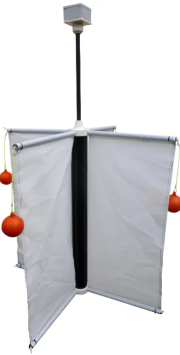
The design of the CODE drifter structure can be easily replicated using universally available off -the-shelf products. In particular, the low-cost CODE drifter proposed is built out of parts from the building industry (the vertical tube which constitutes the main section of the structure and the smaller tubes which form the arms and the antenna mast, as well as the floating buoys), from the fishing industry (the ropes that join the buoys to the drifter arms) and from residential electrical components (the box containing the electronic and the batteries), as shown in Figure 1. The arms’ slots (top and bottom) and the box coupler which joins
Figure 1. Low-cost CODE drifter equipped with LoRa transceiver in the box
the antenna mast with the waterproof (IP68) box were milled from a block of PVC (poly Vinyl Chloride). Both the internal and the external diameters of the tubes as well as the diameter of the floating buoys are slightly different from the values of the original design, but the buoyancy and the centre of gravity were adjusted to very closely match those of the standard CODE drifter (compare Table 3 and Table 6 of [17]).
4.2. Electronic Design
The electronic of the drifter has been designed to perform the following tasks:
• Measure the position via GPS
• Store the data locally in a microSD card on the electronic board
To perform such tasks we chose a LoPy board [18] from Pycom fitted with a PyTrack module. The LoPy is an embedded device running microPython which in addition to a microcontroller has three radios for WiFi, Bluetooth and LoRa. It has an external antenna connector and during our tests we used a small omnidirectional rubber duck antenna and an adhesive flat antenna. The PyTrack is an additional module with a GPS receiver, a microSD card holder and an accelerometer. The whole system can be powered via microUSB using an external battery. We did not implement the deep-sleep functionalities of the board as our tests were short and the external battery provided enough power, but they will be included in the next iteration of the design.
5. Operational tests at sea
The drifter equipped with the LoRa transceiver was deployed for the first time at sea on October 17th, 2017 in the Gulf of Trieste (northern part of the Adriatic Sea), to test the performance in the marine environment of the antenna at sea-level with a single LoRa Gateway. The experiment lasted for about one hour, then the drifter was recovered and stored on board the boat while we kept cruising the Gulf to assess the coverage of the gateway .
A second test at sea was performed on March 22nd, 2018, (Figures 2 and 3) to assess the drifter performance under stronger wind and using two LoRaWAN gateways. Winds were moderate (Bora from E-NE) and increased a bit during the experiment [19].
We setup the LoPy board so that it would send GPS data every 30 seconds to the TTN gateways and save the same data every 10 seconds on the microSD card as backup. We deployed one drifter with both LoRa and SPOT transmitters and another drifter with only the SPOT device. Both SPOTs were configured to send data every 15 minutes.
During the first phase of the test, the drifters were released offshore, as shown in Figure 3, and left adrift within the wind-generated current for about one hour. Then, the drifters were recovered and re-deployed near the coast where the effect of the wind on the current was less evident and the drifters could describe small scale features. The second phase lasted about 2.5 hours.
Once back in the lab, we tested the GPS accuracy by placing both the PyTrack and the SPOT on the ICTP building’s roof, with clear sky view.
6. Results and discussion
6.1. LoRaWAN coverage
The October 2017 test demonstrated a good coverage of the system in terms of Received Signal Strength
Figure 2. Drifter deployment in March 2018
Figure 3. Drifters in the water during the March 2018 experiment in the Gulf of Trieste
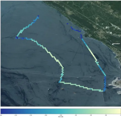
Figure 4. Coverage of the gateway located at Monte Grisa
Figure 5. Links established by the drifter to the gateways at ICTP (upper) and Monte Grisa (lower)
When running the experiment at sea in March 2018, we assessed the coverage of two TTN gateways, one on top of the ICTP building in Miramare at 80 m Above Sea Level (ASL), and another in Monte Grisa at 330 m ASL. Figure 5 shows the links from the LoRa transmitter on the drifter to the two gateways. In many measurements, both gateways were receiving data, and the TTN server would select the gateway which had received the stronger signal to forward this data to the application server in the Internet.
Figure 6 shows the coverage in terms of Received Signal Strength Indicator (RSSI), where the yellow dots indicate an RSSI up to -109 dBm and red indicate an RSSI up to -115 dBm. While these values are considered at the limit of what can be decoded by most wireless
Figure 6. Gateway coverage in terms of Received Signal Strength Indicator (RSSI)
systems, the LoRa chipset in the LoPy has a sensitivity of -134 dBm, leaving ample margin for farther links.
6.2. Drifter trajectories
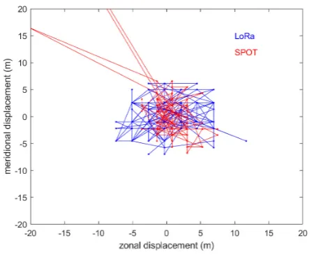
The trajectories of the drifters during the two phases of the second test carried out in March 2018 are shown in Figures 7 and 8. Both drifters move coherently with the surrounding waters and diverged less than 5-10 m (compare the green and red lines derived from the respective SPOT transmitters). The blue track depicts the data sent by the LoRa transceiver while the red one shows the data from the SPOT transmitter, both mounted on the same drifter. Obviously, the trajectory depicted by the LoRa is much more detailed than the one recorded by the SPOT, since the first transmits every 30 seconds while the latter every 15 minutes. During the second phase we also artificially generated a current anomaly with the propeller of the boat for about 4 minutes in the south direction. PyTrack recorded the anomaly three times (at about 13.7085°E).
6.3. GPS accuracy
We recorded the GPS position measurements at a fixed location on top of ICTP building for about 24 hours using the PyTrack module and the SPOT next to each other. The PyTrack collected 2310 measurements (one every 30 seconds), while Spot sent 262 measurements (one every five minutes). The results are shows in Figure 9. The GPS accuracy obtained by the LoRa system (and by the SPOT) is comparable to that of the standard CODE drifter (about 8 meters, [20]). The SPOT showed a couple of erroneous spikes while the PyTrack did not.
6.4. Discussion
Figure 7. Drifter trajectories during the first phase of the experiment carried out in March 2018 (blue = Drifter 1 - LoRa data; red = Drifter 1 - SPOT data; green = Drifter 2 - SPOT data)
Figure 8. Drifter trajectories during the second phase of the experiment carried out in March 2018 (blue = Drifter 1 - LoRa data; red = Drifter 1 - SPOT data; green = Drifter 2 - SPOT data)
• The LoRa gateways configuration showed reliable data transmission up to 10km with two different types of antennas mounted on the drifter, about 30 cm above the sea surface. Additionally, given the results of other tests at sea that we have performed we estimate that much longer links are feasible with the same gateway.
• The positions obtained from the PyTrack mounted on the LoRa board are comparable to those transmitted by the SPOT mounted on the same drifter. LoRa allows much higher (up to 1 Hz)
Figure 9. GPS fixes recorded on-top the ICTP roof (displacements in m)
sampling rate than the SPOT which can send data up to every 5 minutes. In the March 2018 experiment the LoRa system was able to record a current anomaly artificially generated for a limited period of time (4 minutes) while the SPOT did not catch it. Such a higher resolution enables the study of smaller horizontal structures with better temporal resolution. Hence, it allows to better describe the dispersal of pollutants and contaminants and to study the dominant physical and biogeochemical processes near the ocean surface.
• The higher sampling rate allowed by the LoPy devices enhances the chances of being able to recover the drifter when longer tests are performed. This is an important feature for deployments in developing countries where the budget for scientific devices is very limited. In strong current conditions, a sampling rate of 30 seconds Vs one of 5 minutes can make a huge difference.
6.5. Comparison of drifter designs and of
transmission technologies
Several tests and experiments [12] [21] [22] [23] were carried out at sea using together the low-cost and the standard CODE drifters. They demonstrated the equivalence of the two designs both in terms of current-following capabilities and mechanical behavior.
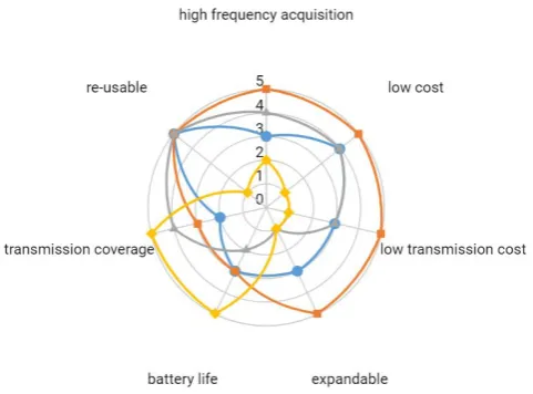
Drawing from the tests discussed in the above paragraph, previous experience and relevant literature, a comparison of drifter transmission technologies: GSM (Cellular), LoRaWAN, SPOT, Standard (commercial) is given in Figure 10. Their suitability to the ideal system requirements is assessed by means of seven indicators evaluated with a score ranging from 0 (lowest) to 5 (highest).
The cost of the equipment and the running cost of the measurement campaigns together with the possibility of easily recover and reuse the instrument are essential aspects for the developing countries.
The standard commercial drifter (available on the market) has the worst score in the corresponding indicators. It costs more than a thousand euros and data are transmitted via satellite link under a service contract (50-100 euros/month per unit with hourly transmission); additionally, the instrument is not expandable and its batteries cannot be replaced. On the other hand the standard drifter is well suited for open ocean applications having a global transmission coverage and a larger battery autonomy (more than a year).
In the case of coastal applications (on which the developing countries are much more oriented), the limited battery life and the transmission coverage do not seem to be a real obstacle since the space and time scales investigated are well within these limits. In addition, some straightforward improvements can enhance the performances (i.e. additional batteries pack in the existing housing and the possibly use of LoRa satellite communication in the near future).
LoRa exhibits the best scores in almost all indicators of Figure 10; GSM and SPOT technologies are in between.
The cost of GSM and SPOT tracking devices is around 100 euros while LoRaWAN costs less than the half. LoRaWAN outclasses all the transmission technologies in the expandability (the LoPy board is ready to host several additional sensor as plug and play systems), in frequency acquisition (up to 1 Hz) and in the transmission costs (TTN gateway costs about 100-200 euros one-time, while data are transmitted at no cost). GSM drifter must to be within the coverage of a terrestrial cellular phone network (which is not always guaranteed for free drifting buoys) and to subscribe a service contract with recurring costs and possible roaming issues.
Figure 10. Comparison of transmissions technologies for drifters: GSM, LoRa, SPOT, Standard)
7. Conclusions and future work
The pilot application of a LoRaWAN low-cost drifter in a coastal area (Gulf of Trieste) has shown that the system, built using low-cost off-the-shelf components, has at least the same performances as drifters which cost about three times, and does not incur in the cost of the Iridium/SPOT transmission services. The use of LoRaWAN can allow a multiplicity of drifters to operate simultaneously in the same area, providing a rich and homogeneous database for statistical post processing. The high transmission rate allows an almost real time position reporting, simplifying the drifter recovery for a successive reuse. A limited number of LoRaWAN gateways ensures a good coverage for relatively large semi enclosed basins. For longer distances from the coast, it might be possible to use the LoRaWAN satellite technology that some companies are starting to offer as a service [24].This is well suited for any Internet of Things (IoT) devices that need broader, continuous coverage, eliminating the range limitation imposed by terrestrial gateways. The associated recurring costs might be justified for operation at very long distance from the coast. Additional improvements can be achieved (at no cost) by integrating three accelerometers on the PyTrack to obtain the 3D displacements and to estimate the parameters of the directional wave motion. These are very important for coastal protection and coastal activities. The use of differential GPS can significantly improve the accuracy of position determination, which allows for other research applications which require better granularity of this parameter. We will implement differential GPS in future work.
and assistance during the realization of the low-cost drifter, of the data acquisition scripts and during the tests. We would also like to thank Carlo Franzosini and Marco Segarich for their help during the tests at sea.
References
[1] World Bank and United Nations Department of Economic and Social Affairs (2017). The Potential of the Blue Econ-omy: Increasing Long-term Benefits of the Sustainable Use of Marine Resources for Small Island Developing States and Coastal Least Developed Countries. World Bank, Washington DC.
[2] OpenMODs - Open Access Marine Observation Devices. Retrieved from the URL http://ocean-partners.org/OpenMODs. Web. 29 May 2018.
[3] Al-Zaidi, R., Woods, J. C., Al-Khalidi, M., & Hu, H. (2018). Building Novel VHF-based Wireless Sensor Networks for the Internet of Marine Things. IEEE Sensors Journal. [4] Oceans 2.0: An Internet of Things for the Ocean.
Retrieved from Ocean Network Canada (ONC) http://www.oceannetworks.ca/oceans-20-internet-things-ocean Web. 29 May 2018.
[5] Lumpkin, R. and Pazos, M. (2007). Measuring surface currents with Surface Velocity Program drifters: the instrument, its data, and some recent results, Chapter two of Lagrangian Analysis and Prediction of Coastal and Ocean Dynamics (LAPCOD), edited by: Griffa, A., Kirwan, A. D., Mariano, A. J., Ozgokmen, T., and Rossby, T., Cambridge University Press, 39-67.
[6] Sybrandy, A. L. and Niiler, P. P. (1991). WOCE/TOGA Lagrangian drifter construction manual, Scripps Institu-tion of Oceanography, San Diego, California, SIO REF 91/6, WOCE Report 63.
[7] Davis, R. E. (1985). Drifter observation of coastal currents during CODE. The method and descriptive view. J. Geophys. Res., 90, 4741-4755.
[8] Poulain, P.-M. and R. Gerin, 2018. Assessment of the water-following capabilities of CODE drifters based on direct relative flow measurements. Journal of Atmo-spheric and Oceanic Technology, submitted.
[9] Centurioni, L. R. (2018). Drifter Technology and Impacts for Sea Surface Temperature, Sea-Level Pressure, and Ocean Circulation Studies. In Observing the Oceans in Real Time (pp. 37-57). Springer, Cham.
[10] Abbott, M. R., J. G. Richman, R. M. Letelier, and J. S. Bartlett (2000), The spring bloom in the Antarctic Polar Frontal Zone as observed from a mesoscale array of bio-optical sensors, Deep-Sea Research Part II-Topical Studies in Oceanography, 47(15-16), 3285-3314.
[11] Griffa, A. (1996). Applications of stochastic particle models to oceanographic problems. In Stochastic mod-elling in physical oceanography (pp. 113-140).
[12] Bellomo, L., Griffa, A., Cosoli, S., Falco, P., Gerin, R., Iermano, I., ... & Mamoutos, I. (2015). Toward an integrated HF radar network in the Mediterranean Sea to improve search and rescue and oil spill response: the TOSCA project experience. Journal of Operational Oceanography, 8(2), 95-107
[13] The Rise and Fall and Rise of Iridium Retrieved from Air & Space Magazine https://www.airspacemag.com/space/the-rise-and-fall-and-rise-of-iridium-5615034/ Web. 29 May 2018. [14] Spot Satellite Messenger Retrieved from
https://en.wikipedia.org/wiki/SPOT Satellite Messenger/ Web. 29 May 2018.
[15] What is the LoRaWAN Specification? Retrieved from LoRa Alliance https://lora-alliance.org/about-lorawan Web. 29 May 2018.
[16] The Things Network Retrieved from The Things Network homepage https://www.thethingsnetwork.org/ Web. 29 May 2018.
[17] Gerin R., Zuppelli P. and Poulain P.-M. (2016). Design and tests of the OGS low-cost CODE drifter. REL. OGS 2016/12 OCE 7 MAOS, Trieste, Italy, 25 pp.
[18] LoPy specifications Retrieved from Pycom https://pycom.io/hardware/lopy-specs/ Web. 29 May 2018.
[19] National Institute of Biology, Marine Biology Station Piran, Slovenia Retrieved from NIB http://www.nib.si/mbp/en/oceanographic-data-and-measurements/buoy-2/general-2 Web. 29 May 2018. [20] Barbanti, R., Iungwirth, R. and P.-M. Poulain (2005).
Stima dell’accuratezza del drifter tipo CODE con GPS nella determinazione della posizione geografica. Rel. 32/2005/OGA/20, OGS, Trieste, Italy.
[21] Gerin R., Poulain P.-M., Bussani A., Brunetti F., Zervakis V., Kokkini Z., Malacic V. and Cermelj B. (2012). First TOSCA drifter experiment in the Gulf of Trieste (April 2012). REL. OGS 2012/91 OCE 6 SIRE, Trieste, Italy, 32 pp.
[22] Gerin R., Poulain P.-M., Bussani A., Brunetti F., A. Kalampokis, G. Nicolaides, Malacic V. and Cermelj B. (2013). Second TOSCA drifter experiment in the Gulf of Trieste (October 2012). REL. OGS 2013/36 OCE 19 MAOS, Trieste, Italy, 22 pp.
[23] Gerin R., Zuppelli P. and Poulain P.-M. (2016). Design and tests of the OGS low-cost CODE drifter. REL. OGS 2016/12 OCE 7 MAOS, Trieste, Italy, 25 pp.