© 2017, IRJET | Impact Factor value: 5.181 | ISO 9001:2008 Certified Journal | Page 610
A Review on: Spatial Image Processing and Wireless Sensor Network
design to Identify Rainfall Triggered Landslide
K.Anitha
1,
J. Vaideeswaran
21
Assistant Professor, Department of Electronics and communication engineering
SCSVMV University, Kanchipuram, Tamil Nadu, India
2
Professor, Department of Electronics and communication engineering
SCSVMV University, Kanchipuram, Tamil Nadu, India
---***---Abstract :
Landslide is a natural disaster damagesenvironmental structure and makes losses in human lives. Landslide can be classified into different types depends on the factors influencing to trigger landslide. This study focuses a review on forecasting of the rainfall triggered landslide by collectively using two technologies were Geographical information system (to identify and validate landslide occurrence spatial regions) and wireless sensor networking (monitoring and providing early warning to reduce losses)
Key Words: Landslide, spatial image processing, WSN design, DSR Routing protocol
1.
Introduction:
Landslide is the one of the destructive disaster majorly occurs in the hilly areas, causes of landslide depend on the various triggering (natural, manmade) factors. Landslide monitoring is very important in hilly areas for that landslide forecasting and early warning system is needed[1]. The majority of landslides occurs during monsoon periods which causes major loss in life and properties, the losses can be reduced with the help of landslide early warning systems [2][3]. In real time the slope failure occurs after the heavy rainfall, by utilize the time interval between rainfall peak and slope failure the landslide forecasting system can be distorted into early warning system [4]. Monitoring of Wide range of geological region is necessary for the disaster management. Identification of landslide prone areas is necessitate to the planner and decision makers for mitigation actions [5]. According to [6] Landslide evaluation, vulnerability mapping , monitoring and early warning system plays vital role in landslide forecasting and disaster mitigation. With the help of spatial data (database which contains analysis and identification of the susceptible landslide zonation based on the history of landslide occurred events),and real time monitoring field data the analyzer and decision maker can able to manage disaster mitigation and make early warning [7]
2. Landslide forecasting methods:
The landslide disaster happens due to hazard impacts on the susceptible inhabitants and causes damage in environment, properties, society structure, loss of human lives and distraction. Landslide Disaster forecasting or landslide disaster risk management is basically the measure of hazards or vulnerability of the elements at risk, and activities taken to reduce damages and losses caused by the disaster. The method of landslide forecasting involves into theoretical, analytical, numerical studies and field investigation, lab experiment, monitoring, along with the inventory mapping by using GIS/Remote sensing application[8]. The landslide forecasting can be classified into Spatial forecasting and Real time forecasting.
3. Spatial forecasting
When the slop of the hills loses its strength towards earth gravity then Landslide type of geological disasters happens in short span of time, but take some period to allow (some factors like rainfall intensity, soil moisture, pour pressure, landuse, ect…,) changes in its geological structure. Landslide triggering condition depends on changes in the various geological factors (slop, aspect, landuse, lithology, landcover, geomorphology, road buffer…). Geotechnical analysis can endow with an efficient way of detect and identifying instability [9][10]. As the definition Geographic Information System (GIS) is a system designed to capture, store, manipulate, analyze, manage, and present spatial or
geographic data. GIS proved it has been a powerful tool for
analysis of spatial data and very important for landslide study[10]. Refer table-1 GIS Methods used in landslide research around the world.
Table – 1: GIS Methods used in landslide research
Si.No country Previous Research
1 U.K Pauline E. Miller et al. 2012 2 India Muthukumar, M, 2013; PVSP
© 2017, IRJET | Impact Factor value: 5.181 | ISO 9001:2008 Certified Journal | Page 611
Prasada Raju et al.1999; Sundaram, A et al. 2012; Arora, M. K. et al. 2004; Naveen Raj, T et al. 2011; Vishwa B. S et al.2011 3 China S.B. Bai et al. 2008; Yiping, Wu et
al. 2009; Wu Caiyan et al.2011; Wang Rixu et al. 2010
4 Korea Lee, S et al. 2002; Lee, S et al. 2000
5 Indonesia Dodi Sudiana et al.2011 6 North Bohemia Raška, Pavel et al. 2016
7 Switzerland J.Wang et al. 2009; Willenberg et al. (2009)
8 Taiwan Tsutsui.K et al.2007; Cheng-Han Lin et al. 2015
9 Canada Jacek Malczewski, 2006
10 Italy Wooten et al. (2008); Catani et al. (2005)
11 Japan Ayalew et al. 2004
12 Malaysia Prahdan ,2007 13 USA Baum et al. 2005
In the landslide study the geo-technical analysis can be used
To identify factors causes landslide
To identify landslide susceptibility zonation
To identify landslide triggering conditions
Many of the researchers (Muthukumar, M., 2013, sundaram, A, 2012, Arora, M. K. et al; 2004, Vishwa B. et al. 2011, Tien Bui et al. 2012, Qiao.G et al.2013 ) were analyzed some common geological factors like Slope, Aspect, Drainage Buffer, landuse/ landcover, soil type, distance to roads, distance to rivers, distance to faults, and rainfall to analyze, identify and validate landslide susceptibility zonation by using the GIS technology. The spatial analysis will provide the complete spatial database about the monitoring region which can support real time monitoring system.
4.Real time Monitoring
WSN provides flexibility in the field data measurement with more accuracy, long distance communication to various points and the potential of real time control. Because of these reasons the landslide prediction system with WSN becomes more effective[11][12].
In landslide forecasting scenario, Sensors are integrated with the wireless module (contains transmitter, receiver, processor, power supply unit) and scattered in the monitoring field, it collect data depends on the changes in
the field and send to control unit or station through sink node and base station[12][13]. According to the authors [14][15][16][17][18][19], the landslide monitoring and detection system architecture is shown in the below Figure 1.
5. Sensor network design Requirements:
The sensor node deployed in the field with different sensors (Rain gauge, tilt meter, Piezometer, Crack meter)to measure the relevant parameters of the slope stability like ground water condition, ground displacement, surface water condition, rainfall level, temperature[12][17][20].
For the real time landslide detection and early warning system, the network architecture should need the important concerns like fault tolerance, energy efficiency, minimum delay, node connectivity and node life[2][21][17].
With the limited power sensor nodes will be deployed in the remote field for the landslide forecasting, therefore low power consumption and strong connectivity is the important consideration for sensor network design. The maximum power losses will occur during the transformation of the measured data by the node, so by reducing delay in data transformation and sleep and wakeup based data aggregation method will be effectual to achieve minimum power conception. Some of the network topology and algorithms used in pervious landslide research is gin in table-2.
For the disaster management most of the researchers have been selected clustering protocols for ad hoc network structure, which supports measure of different parameters from different nodes and analysis data from nodes to predict the natural disaster before it occurs. In the wireless communication network, the nodes use peer-to-peer transmission and multi-hop routes then the mobile network will be classified as mobile ad hoc network. It can operate without any infrastructure or fixed base station. Hence ad- hoc network can bear great potential in disaster relief applications. [22]
© 2017, IRJET | Impact Factor value: 5.181 | ISO 9001:2008 Certified Journal | Page 612
for the ad hoc sensor network [23]. DSR protocol provide better performance, low power consumption and average
[image:3.612.71.529.141.427.2]end to end delay compared with other ad hoc protocols [21] [24].
Figure 1: Desingn and WSN network archistructure of wireless
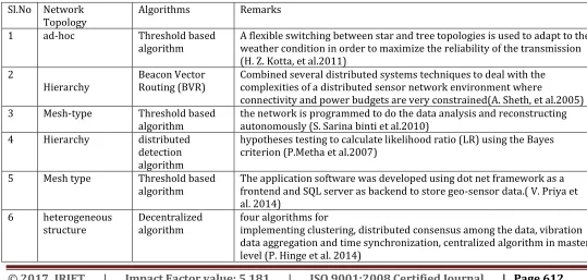
Table – 2: Network Topology and algorithms used in landslide Disaster:
Sl.No Network
Topology Algorithms Remarks 1 ad-hoc Threshold based
algorithm A flexible switching between star and tree topologies is used to adapt to the weather condition in order to maximize the reliability of the transmission (H. Z. Kotta, et al.2011)
2
Hierarchy Beacon Vector Routing (BVR) Combined several distributed systems techniques to deal with the complexities of a distributed sensor network environment where
connectivity and power budgets are very constrained(A. Sheth, et al.2005) 3 Mesh-type Threshold based
algorithm the network is programmed to do the data analysis and reconstructing autonomously (S. Sarina binti et al.2010) 4 Hierarchy distributed
detection algorithm
hypotheses testing to calculate likelihood ratio (LR) using the Bayes criterion (P.Metha et al.2007)
5 Mesh type Threshold based
algorithm The application software was developed using dot net framework as a frontend and SQL server as backend to store geo-sensor data.( V. Priya et al. 2014)
6 heterogeneous
structure Decentralized algorithm four algorithms for implementing clustering, distributed consensus among the data, vibration data aggregation and time synchronization, centralized algorithm in master level (P. Hinge et al. 2014)
[image:3.612.29.568.481.738.2]© 2017, IRJET | Impact Factor value: 5.181 | ISO 9001:2008 Certified Journal | Page 613
7 autonomous Threshold based
algorithm GIS has been integrated into the monitoring system(Smarsly, K et al. 2012) 8 heterogeneous Four algorithms Network structure divided into Probe network, Field LAWN, Adaptive
WAWN, each level different algorithms were used(M. Ramesh et al,. 2014)
6. Conclusion
This study was conducted to identify the wireless sensor network design requirement for landslide disaster forecasting and to evaluate the support of the spatial image processing to node deployment and sensor data analysis. Further this work will be carried to prepare landslide hazard zonation (LHZ) map for the particular study area and by implementing DSR protocol in ad hoc network to design energy efficient network for rainfall induced landslide.
7. References
[1] G. P. Ganapathy and C. L. Hada, “Landslide Hazard Mitigation in the Nilgiris District, India – Environmental and Societal Issues,” Int. J. Environ. Sci. Dev., vol. 3, no. 5, pp. 497–500, 2012.
[2] Z. Yu, S. Xu, S. Zhang, and X. Yang, “Distributed Detection in Landslide Prediction Based on Wireless Sensor Networks,” in Conference on Dependable Computing (CDC’2010), 2010, pp. 1–4.
[3] P. Mehta, D. Chander, M. Shahim, K. Tejaswi, S. N. Merchant, and U. B. Desai, “Distributed Detection Prediction Wireless Sensor Network for Landslide using,” in Global Information Infrastructure Symposium, 2007. GIIS 2007. First International., 2007, pp. 2–5.
[4] Y. Hong, R. F. Adler, and G. Huffman, “An Experimental Global Prediction System for Rainfall-Triggered Landslides Using Satellite Remote Sensing and Geospatial Datasets,” IEEE Trans. Geosci. Remote Sens., vol. 45, no. 6, pp. 1671–1680, Jun. 2007.
[5] I. Journal, O. F. Selected, T. Earth, and O. Sensing, “Manifestation of LiDAR-Derived Parameters in the Spatial Prediction of Landslides Using Novel Ensemble Evidential Belief Functions and Support Vector Machine Models in GIS ARTICLE in IEEE JOURNAL OF SELECTED TOPICS IN APPLIED EARTH OBSERVATIONS AND REMOTE,” IEEE J. Sel. Top. Appl. EARTH Obs. Remote Sens., vol. 8, no. February 2016, pp. 674–690, 2014.
[6] G. Qiao, P. Lu, M. Scaioni, S. Xu, X. Tong, T. Feng, H. Wu, W. Chen, Y. Tian, W. Wang, and R. Li, “Landslide Investigation with Remote Sensing and Sensor Network: From Susceptibility Mapping and Scaled-down Simulation towards in situ Sensor Network Design,” Remote Sens., vol. 5, no. 9, pp. 4319–4346, Sep. 2013.
[7] Y. Chao, Y. Li, and M. Qing, “Research on application of temporal GIS technology in monitoring landslide hazard,” in Multimedia Technology (ICMT), 2011 International Conference on. IEEE, 2011, pp. 5039– 5043.
[8] T. Sassa, K., Tsuchiya, S., Ugai, K., Wakai, A., & Uchimura, “Landslides : a review of achievements in the first 5 years,” Springer-Verlag, vol. 6, no. September, pp. 275–286, 2009.
[9] P. E. Miller, J. P. Mills, S. L. Barr, S. J. Birkinshaw, A. J. Hardy, G. Parkin, and S. J. Hall, “A Remote Sensing Approach for Landslide Hazard Assessment on Engineered Slopes,” IEEE Trans. Geosci. Remote Sens., vol. 50, no. 4, pp. 1048–1056, Apr. 2012.
[10] A. Sundaram, “An approach for remote sensing and GIS based landslide hazard zonation mapping in Sirumalai Hill , Tamil Nadu,” Remote Sens., vol. 51, pp. 10829–10833, 2012.
[11] H. Z. Kotta, K. Rantelobo, S. Tena, and G. Klau, “Wireless Sensor Network for Landslide Monitoring in Nusa Tenggara Timur,” TELKOMNIKA, vol. 9, no. 1, pp. 9–18, 2011.
[12] A. Rosi, N. Bicocchi, G. Castelli, M. Mamei, F. Zambonelli, and R. Emilia, “Landslide Monitoring with Sensor Networks : Experiences and Lessons Learnt from a Real-World Deployment,” Int. J. Sens. Networks, vol. 10, no. 3, pp. 1–11, 2011.
[13] P. K. Mishra, S. K. Shukla, S. Dutta, S. K. Chaulya, and G. M. Prasad, “Detection of Landslide Using Wireless Sensor Networks,” IEEE, pp. 3–6, 2011.
© 2017, IRJET | Impact Factor value: 5.181 | ISO 9001:2008 Certified Journal | Page 614
2012 8th International Conference on WirelessCommunications, Networking and Mobile Computing, 2012, pp. 1–4.
[15] N. Dinh, T. Duc, T. D. Nghia, and T. Duc-Tuyen, “Development of a Rainfall-Triggered Landslide System using Wireless Accelerometer Network,” Int. J. Adv. Comput. Technol. ·, no. JANUARY, 2015.
[16] E. Lule, “A Scalable Wireless Sensor Network ( WSN ) Based Architecture for Fire Disaster Monitoring in the Developing World,” I.J. Comput. Netw. Inf. Secur. 2015, no. January, pp. 40–49, 2015.
[17] M. V. Ramesh, “Design, development, and deployment of a wireless sensor network for detection of landslides,” Ad Hoc Networks, vol. 13, no. PART A, pp. 2–18, 2014.
[18] P. Hinge, R. Bawage, and P. Hinge, “Wireless Sensor Network for Detecting Vibrations Before Landslides,”
Int. J. Eng. Res. Technol., vol. 3, no. 10, pp. 23–26, 2014.
[19] P. Mehta, B. Jagyasi, K. Tejaswi, R. Bansal, C. Parekh, A. Sheth, S. N. Merchant, T. N. Singh, C. A. Thekkath, and U. B. Desai, “DISTRIBUTED DETECTION STRATEGIES FOR LANDSLIDE PREDICTION USING WIRELESS SENSOR NETWORKS,” in Proceedings of the IEEE Global Information Infrastructure Symposium, GIIS. Vol. 2007. 2007., 2007.
[20] V. Priya, S. Rath, K. Buragohain, and P. C. Sarmah, “Real-Time Monitoring System for Landslide Prediction Using Wireless Sensor Networks,” Int. J. Mod. Commun. Technol. Res., no. 12, pp. 14–19, 2014.
[21] N. Pogkas, G. E. Karastergios, C. P. Antonopoulos, S. Koubias, and G. Papadopoulos, “Architecture {Design} and {Implementation} of an {Ad}-{Hoc} {Network} for {Disaster} {Relief} {Operations},” IEEE Trans. Ind. Informatics, vol. 3, no. 1, pp. 63–72, 2007.
[22] J. Huang, X. Fan, X. Xiang, M. Wan, Z. Zhuo, and Y. Yang, “A Clustering Routing Protocol for Mobile Ad Hoc Networks,” Math. Probl. Eng., vol. 2016, 2016.
[23] A. A.-M. Ihbeel and H. I. Sigiuk, “Performance Evaluation of Dynamic Source Routing Protocol (DSR) on WSN,” Int. J. Comput. Digit. Syst., vol. 1, no. 1, pp. 19–24, 2012.
[24] V. K. Taksande, “Performance Comparison of DSDV , DSR , AODV Protocol with IEEE 802 . 11 MAC for
Chain Topology for Mobile Ad-hoc Network using NS-2,” October, pp. 26–31, 2011.