Travis B. Roscher. Information and the Backcountry: A survey of the technologies available for leveraging information throughout a remote wilderness experience. A Master’s Paper for the M.S. in I.S degree. April, 2009.60pages.Advisor: Deborah Barreau.
The purpose of this study is to examine the conditions surrounding information use in the backcountry and technologies that enable it. First, the existing literature will be reviewed to determine the climate for the adoption of information enabling technologies in the backcountry. Specifically considered will be the users of information and the nature of information needs, which may vary from user to user. Then current technologies and their impact on information use will be examined. A formula was created to assess the extent to which these technologies fulfill information needs and how likely they are to be used. Limitations of current technologies as pertains to their use in backcountry settings will be discussed. Finally, conclusions about information enabling devices will be drawn.
Headings:
IT in the environment
Remote wilderness study/experience Information use
Technology adoption conflicts User study
INFORMATION AND THE BACKCOUNTRY: A SURVEY OF THE TECHNOLOGIES AVAILABLE FOR LEVERAGING INFORMATION
THROUGHOUT A REMOTE WILDERNESS EXPERIENCE
by
Travis B. Roscher
A Master’s paper submitted to the faculty of the School of Information and Library Science of the University of North Carolina at Chapel Hill
in partial fulfillment of the requirements for the degree of Master of Science in
InformationScience.
Chapel Hill, North Carolina April 2009
Approved by
TABLE OF CONTENTS
Page
LIST OF TABLES AND FIGURES...3
INTRODUCTION ...4
PROBLEM OVERVIEW ...6
Information Users ...7
Information Uses ...8
Information Needs ...9
REVIEW OF LITERATURE ...14
History...16
Trends ...17
Controversy ...18
Impacts ...21
METHODS ...22
Concepts and Measures...23
Evaluation ...29
RESULTS ...30
Garmin Rino 530 HCx ...30
Apple iPhone ...32
Globalstar Qualcomm GSP 1600 Handheld Phone ...35
SPOT Satellite Messenger ...38
LIMITATIONS ...40
DISCUSSION ...41
CONCLUSION ...45
REFERENCES ...49
APPENDIX A: EXAMPLES OF TECHNOLOGICAL DEVELOPMENTS ...54
APPENDIX B: CATEGORIES OF TECHNOLOGICAL EFFECTS...55
APPENDIX C: PARTIAL LIST OF ADVENTURE ACTIVITIES ...56
List of Tables and Figures
Page
FIGURE 1: A MODEL OF INFORMATION BEHAVIOR ...9
TABLE 1: DESCRIPTION OF POINT SYSTEM ...24
TABLE 2: SCORECARD FOR GARMIN RINO 530HCX ...30
TABLE 3: SCORECARD FOR APPLE IPHONE ...34
TABLE 4: SCORECARD FOR GLOBALSTAR QUALCOMM GSP 1600 ...35
TABLE 5: SCORECARD FOR MCMURDO FAST FIND 210 ...37
TABLE 6: SCORECARD FOR SPOT ...38
Introduction
Over the course of history, there have been many people who have walked into
the remote Alaskan backcountry never to return. One man caused quite a stir by doing so
in 1992. His name was Christopher J. McCandless, and after graduating from Emory
University in 1990, he embarked on an adventure through the Last Frontier, as Alaska is
sometimes called (Alaska Office of Economic Development, 2007). In April of 1992,
McCandless was dropped off at the trailhead of the Stampede Trail with very minimal
supplies to face the wild. By August, he had died (Krakauer, 1996.) John Krakauer
wrote an account of McCandless’ life in Outside magazine in 1993. In this article, which
later became a book, and then a movie, Krakauer reveals a small but crucial piece of
information that, had McCandless known, he might still be alive.
McCandless had crossed the Teklanika River in April to reach the site where he
established camp for the next four months. By the time he was ready to rejoin
civilization, the river was running far too high for him to cross because of snow melt.
When he was unable to ford the river, he returned to camp where starvation overtook
him. Krakauer points out that only a quarter of a mile downstream there was a cable tram
that crossed the river, installed there for just such high water crossings. Had McCandless
known this information he could have crossed the river and returned home (Krakauer,
1996). This lack of information in the backcountry cost McCandless his life.
This may be a particularly extreme example and perhaps one that is not fair;
backcountry. Information technologies can help people avoid a similar fate, but only if
they are willing to use these technologies. From reading Krakauer’s account of
McCandless’ adventure, which was based in large part on a journal kept by McCandless, it
became apparent that McCandless rejected information or technologies that would help
him access information. In fact, he shunned both. But information and the technologies
that enable people to leverage information – whether it be maps, cell phones, computers,
or the next thing not yet invented – are here to stay (or will be soon). Therefore, use of
these information enabling technologies in the backcountry to help keep people safe
should be encouraged.
A contrast to the story of McCandless, for example, is the case of Jason Tavaria.
In March of 2009, Tavaria was snowboarding in the Swiss Alps when inclement weather
overtook his group. Tavaria was separated from the group and lost his way. Using
Twitter and his iPhone’s global positioning system (GPS) functionality Tavaria was able
to guide rescuers to his location who then safely assisted him out of the wilderness
(Malvern, 2009).
These two stories demonstrate that information can play an important role in
various aspects of any given backcountry setting. Had McCandless taken a map – or even
looked at one when planning his journey – he might have known that there was a tram to
help him cross the river. Had Tavaria not been willing to take his phone with him on his
outing, had he not been able to find his location from the GPS built into his phone and
then use its communication abilities to share this information, Tavaria might not have
survived. The lack of information cost McCandless his life, while information
Problem Overview
To date, no extensive studies have been done regarding how information is
created, stored, shared, or used in the backcountry. There is a lack of discourse
concerning what technologies exist to facilitate these information actions. There is also
little discussion of who might use information in the backcountry or what their
information needs may be. This situation needs to be remedied, as there are a variety of
new and emerging information technologies that could be adopted by people in the
backcountry to protect themselves, and possibly save their lives.
In order to understand the complexities of this situation, there are questions that
need to be asked: What is the backcountry? Who can be found in the backcountry?
What information do these people need to accommodate their backcountry experience?
Why do these people need information? What do they do with information? What form
will their information come in? What encourages some people to use information tools
but not others? What limitations are there on information in the backcountry?
Furthermore, does anyone care? Is this actually important? Do people even want or need
information in the backcountry?
By attempting to answer these questions, it should become evident that this is an
interesting realm to examine, as very little research has been done, and the complex
nature of the setting makes for some intricate yet exciting possibilities. This paper will
suggest a synergy of extant information technologies that could entirely improve the
backcountry experience, despite claims these technologies and the outdoors do not mix.
A few of the questions posed above should be addressed before delving into the
English Dictionary, is “the country lying towards or in the rear of a settled district.”
Merriam-Webster defines it as “a remote undeveloped rural area.” These meanings give
some indication of the meaning of backcountry; however, about.com’s site on camping
provides a better definition: “remote uninhabited areas of public lands, national parks, and
forests… is accessible to hikers, backpackers, and horse riders…” However, this definition
could be amended to include activities such as rock climbing, mountaineering, mountain
biking, kayaking, skiing, or snowshoeing. Terrain varies from one backcountry setting to
the next: canyons in Utah, forests in Maine, and alpine peaks of Colorado are all
backcountry settings. This paper uses the following definition for backcountry: remote
uninhabited areas, recognized or not, where people can go for any recreational activity.
Information Users
Then there is the issue of who can be found in the backcountry. It is a select
group: people who enjoy the outdoors and the challenges that venturing into a remote
wilderness location provides. These are all people who may have information needs, and
therefore may benefit from access to information. The people in question could be called
backcountry information users. How they access information, utilize information, and
the kinds of information they need differentiates them. For this study, there are three
primary categories and one secondary category of backcountry information users. The
types of information and the means of access to information will vary based on the user
in question. The three primary categories are adventurers, administrators, and
responders. An adventurer is anyone who uses the backcountry to undertake some sort of
recreational activity. People utilizing the backcountry for hiking, backpacking, kayaking,
example of administrators, although anyone tasked with monitoring, patrolling,
conserving, or otherwise overseeing an area of the backcountry could also be included in
this category. The last primary category is the people involved in search and rescue, the
responders. Finally, the secondary category includes everyone involved in the lives of
those in the backcountry. This means family, friends, and co-workers or bosses who
need to know information about their outdoor loving acquaintances.
Information Uses
In order to help information users fulfill their information needs, they must have
avenues to interact with information. Because information use has been well studied in
the past, I will only briefly mention it here. Choo (1996) writes about “the knowing
organization” and how organizations use information, and applying some of his theories to
the individual backcountry user can provide some insight. To modify Choo’s ideals on
the creation and use of information for the individual, we would have three distinct areas.
First, information is searched for and evaluated in order to make decisions. A key
component of this area is that the choice should be made rationally, but in practice the
decision making is usually complicated by any number of external factors. In the case of
the backcountry user, the lack of information is foremost among them. Second, the
individual must make sense of changes and developments in its external environment (as
well as his internal environment.) I liken this idea to situational awareness, as so much of
the backcountry experience is responding to the changes in conditions around the
backcountry user. Finally, individuals “create, organize, and process information in order
people can do with information, it becomes easier to see how information technologies
can be applied to information needs.
Information Needs
The final theoretical piece is the actual information need. Various researchers
have described an information need as a gap in knowledge. Belkin (1980) describes an
“anomalous state of knowledge”, whereby the individual realizes that their current mental
model of their situation has some deficiency and that information is necessary to rectify
this problem. Dervin
(1986) labels her model
“Situation-Gap-Use”.
Similar to Belkin, Dervin’s
model is based on
sense-making. Information
needs occur when an
individual’s internal sense
runs out, and they must
create new sense. “The
sense-maker is stopped in
a situation. Movement is
prevented by some kind of gap. This sense-maker is seen as potentially making some
kind of use of whatever bridge is built across the ‘gap’ the user faces” (Dervin, 1986).
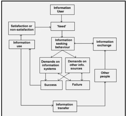
Figure 1, from Wilson (1994), illustrates the theoretical interrelatedness of information
users, information needs, and information uses.
Now, let us put the theories to practice, keeping in mind that part of the allure of
the backcountry is the fact that access to the outside world is less possible there. This
fact greatly impacts the information needs of all users.
For example, the mothers and fathers of adventurers have an information need,
the need to know that their offspring are well. Since those in the backcountry tend to be
outside of cell phone reception, parents or loved ones can never be too sure of the
condition of their children. This secondary group, however, is just a small segment of
those affected. The problems caused for the primary groups are much more intricate.
Just by considering the roles of adventurers, administrators, and responders, it should be
clear that all will have different information needs, and likely different means to achieve
their information needs.
First, consider the adventurer. For the purposes of this paper, the information
needs of the adventurer start when they decide to visit the backcountry. In Clawson’s
(1963) model, this reflects the anticipation stage. Copious amounts of research have been
done on information use at home for various non-work related tasks (Savolainen, 1995),
but I uncovered none relating to the particular task of preparing for a backcountry
excursion. For someone less interested in the actual backcountry experience, I would
suggest that studying the information seeking behaviors of people in the anticipation state
of outdoor recreation activities (of which backcountry outings are a part) could prove an
interesting endeavor. However, an in-depth analysis of this process is beyond the scope
of this paper. Since there are information actions involved that may shape the actual
In order to plan his backcountry experience, an adventurer decides to do some
research. He first picks a backcountry area he is interested in. Then he emails his friend
who was there just last year to ask for any advice on sights to see or places he must visit.
Next he cruises the web - finding driving directions, purchasing a guide book from a
bookstore, checking the weather online. These are all information needs of the
adventurer that are easily met prior to leaving his home. They are not so different from
the non-work, citizen needs discussed by Savolainen. But once the adventurer is out in
the backcountry, these needs change. The information that is important in the field are
things such as the current location, the surrounding terrain, or getting updated weather
forecasts. Checking in with a loved one back home could be important for some
adventurers. He may also be interested in the history of the area he is visiting, human or
natural.
Unlike everyday life information needs, the adventurer may have needs that could
drastically change instantaneously, and the consequences for those needs not being met
could be dire. Should his situation become life-threatening, due to injury, weather, or any
other factor, his information needs may become immediate. With some urgency, he may
need to find the nearest ranger station, or water source. He may simply lose his way and
need access to information such as where the trail is, or where the nearest road is. He
may need to transmit information, such as his current location for rescue. Certainly, a
map can provide some information about the location of amenities or terrain features, but
the user needs to both possess a map and know how to use it, as well as knowing where
he is on the map. Maps are a technology that most backcountry goers utilize and
Even better, a GPS unit could provide mapping information and also provide a tool to
help the user orient himself properly. A compass could do so as well, but there is a
perception that a GPS has a gentler learning curve than a compass, and short of running
out of power, it is hard to use a GPS unit improperly.
Inevitably, the adventurer is out there by himself, or in a small group. His
information needs are generally regarding himself, and are of no concern to other parties.
Nor is he concerned by the whereabouts or statuses of other parties. For the purposes of
this paper, the use of information related to the backcountry experience does not end
when the adventurer returns from the backcountry to his car, however. There is another
component to the information cycle that adventurers exhibit, and that is sharing.
Returning to Clawson’s (1963) model for outdoor recreation experiences, this step is a
part of recollection. This information action, whether sharing the location of a campsite
with a friend, posting pictures on the internet, or filling out a comment card and
submitting it to the park service, is critical as it is how the adventurer completes the
information interaction of that particular backcountry experience.
The needs of adventurers vary greatly from the needs of administrators such as a
ranger who is tasked with monitoring or responding to events in a given backcountry
setting. To a ranger, the pieces of information that may be important are things such as
who is available locally, when the next scheduled resupply is, or how many people have
applied for permits. Rangers are also concerned with threats to the land they help
maintain, and information about threats could come from various sources and forms. For
example, trail conditions may come to the attention of rangers through word of mouth.
hiker returns home, sharing this information with only a friend who will be visiting the
same area the next weekend. Upon his arrival, the friend asks a ranger about the trail he
was warned about. Since the ranger did not know of this condition, the friend tells the
ranger what he knows. Now the ranger is obtaining new information, but it is very
imprecise. Is there substantial downed timber that needs to be removed after the last
storm? Is there trail erosion that is having an impact on the land? This example simply
highlights the complexities that rangers face regarding the information that is available to
them. In general, the information that rangers work with consists of a much greater
number of people and places, and may require some coordination – with headquarters,
with visitors, or with other rangers. There is an underlying assumption here that rangers
have fewer information needs outside of the backcountry experience, since they generally
work in the backcountry and are already acquainted with the area. However, backcountry
administrators could benefit from access to accurate, up-to-date information.
Emergency responders have information needs similar to those of administrators,
although much more specific. Massive coordination efforts are needed on the part of
search and rescue operations, and information sharing becomes critical. Ela (2004)
writes that “search and rescues are a particularly important subset of wilderness problems
to investigate because these incidents expose rescuers to potentially dangerous
conditions.” This notion highlights the difference between the first two groups and the
responders. Unlike the adventurer, who has planned their excursion, or the administrator,
who works in the backcountry environment daily, responders are called into the
backcountry irregularly and at a moment’s notice. They may need to be brought up to
of a person lost in the woods, situational awareness information such as where other
responders are is important to prevent areas from going unsearched, while ensuring that
the maximum area is searched by minimizing overlap, in order to find the person as
quickly as possible.
With a more clear understanding of what the backcountry is, who can be found
there, and what their information needs are, a review of the literature makes it easy to see
that little research has been done about what information technologies are best suited to
help fulfill those needs.
Review of Literature
Research in the realm of information and the backcountry is severely limited.
There is, however, considerable research into related areas from which we can borrow in
order to gain some insights. One such area is adventure recreation. There is a close link
between adventure recreation and backcountry endeavors, as most of the activities
undertaken in the backcountry fall under the umbrella of adventure recreation. From
examining the list of activities that are considered adventure recreation in Appendix C, it
should become clear that backcountry outings are but a subset of adventure recreation. I
am not attempting to equate adventure recreation and a backcountry experience, but
merely to examine whatever literature is out there which could be applied to the
backcountry experience. With that in mind, Ewert (2000) writes the following about
adventure recreation:
Furthermore, its relative newness aside, the subject of adventure recreation is not
traditionally an area where much overlap between information and activities occurs.
More often than not, information technologies are not aimed at fulfilling the information
needs of adventure recreationists, and researchers are not quick to look at the links
between the two. Another issue is that most studies and academic work concerning
adventure recreation are focused on the management of parks and meeting the demands
for adventure recreation in its broadest sense.
However, this is not to say that information technology and the backcountry are
never linked in the literature. If they are to be discussed together, the reason is usually
(1) the historical connections between the two, (2) the prediction of future trends, or (3)
the controversy surrounding the balance of technology and wilderness. I have chosen this
last phrase carefully – the balance of technology and wilderness – because these works only
discuss information technology as a subset of the broader meaning of technology and the
backcountry as a subset of all wild lands, usually those managed by the National Park
Service. For example, according to Ewert and Shultis (1999), a sampling of the recent
technological developments in backcountry recreation would include things such as
automatic descending devices, avalanche beacons, cell phones, collapsible chairs,
hand-held GPS units, Kevlar, filters, plastic climbing boots, personal locator beacons,
snowboards, technical socks, website information sources, and wind-resistant fleece. The
complete table appears in Appendix A. This sampling, however, should indicate clearly
that information technology is simply one faucet of technology as a whole and not
necessarily at the forefront of the concerns of the average recreation or backcountry
running throughout the discussions on the past and present is that there is a double-edged
nature to the interplay of technology and wilderness, while predictions for the future all
seem to include some kind of warning. But before we discuss predictions, we should first
examine the history of technology and the backcountry.
History
Consider that perhaps without technology, the national parks may not have
developed as they have. Borrie (1998), Ewert & Shultis (1999), and Shultis (2001) all
mention that the sense of the need for wilderness was enabled in part by the growth of
technology. For example, the beginnings of the national parks can be traced back to the
Industrial Revolution. Without the invention of the railroad (Shultis, 2001; Ewert &
Shultis 1999) there might not have been a push to protect wild, free lands. The iron horse
enabled easy transportation for the wealthy to elite natural resorts. These destinations
were established in the areas that would later become the national parks (Bella, 1987;
Runte, 1987).
Later on in history, they cite the automobile as a technology that increased public
support for and visitation to the national parks. John Muir, famous explorer and activist,
ardent supporter of wilderness and the preservation of the natural lands, agreed, albeit
grudgingly, that automobiles should be allowed into the parks because cars would lead to
an increase in public use, and in turn funding for such places (Shultis, 2001). Muir was
right, increased public support for the parks because of the larger number of visitors was
advantageous for the parks, but the authors of today are able to point out the downside, in
addition to the benefit provided. Along with the increase in visitors, there was an
While the railroad and the automobile are examples of the broader meaning of
technology, the literature makes clear that without technology, we would not have
developed the sense of wilderness that we have today. Perhaps this is an indication that
technology, with regards to the backcountry, is not pure evil as many consider it to be.
Trends
The second topic found in the literature is predictions and trends. The literature
predicts that visitation to national parks will continue to increase (Eagles, 2004; Ewert,
2000). Eagles also suggests that there will be an increasing demand for sophisticated
management and services, such as online registration for backcountry campsites in the
event that registration is required. It is also suggested that users of the backcountry have
access to an unprecedented amount of information, which makes them more aware of
opportunities in the backcountry, as well as management policies for such areas. These
increased levels of awareness by users of the backcountry will be the cause of some
additional stress for management as the resultant scrutiny of each management decision is
increased (Eagles, 2004; Ewert, 2000; Stankey, 2000). While information technology
has already clearly changed the level of awareness of backcountry users, the notion that it
could be stress inducing should be more fully investigated, although this falls firmly
outside the means of this study. Next, consider that Eagles (2004), Ewert (2000), Shultis
(2001), and Stankey (2000) all suggest that the availability of information technology
will influence visitation in a positive direction. Finally, it has been reported that in the
current economic downturn, more and more people will be turning to the outdoors for
recreation (Sutter, 2009). The situation presents a perfect opportunity to advance the
Strangely enough, one prediction made has already come true. Eagles’ work was
prophetic, as he accurately predicted a device that will be discussed later on in this paper.
Correct predictions such as Eagles’, however, are not normal. For the most part, we do
not possess an ability to correctly predict innovations or their impacts (Shultis, 2001;
Stankey, 2000). Stankey (2000) writes of innovation in general: “Our capacity to
anticipate the future accurately has yet to be demonstrated… Bill Gates’ apocryphal quote
‘640K ought to be enough for anybody’” is a perfect example.
Controversy
However, when it comes to information technology and the backcountry, the topic
that receives the most attention is the interplay between the two. Some claim that there
can be no balance: that the two ideas are set firmly against each other. Others advocate
for seeking a middle ground, although grudgingly. Again, I must stress that most of these
authors refer to technology in the larger sense, but their arguments easily apply to more
specific instances of information technologies, which they view as a subset of
technology.
There are a few ideas that serve as the foundations for the controversy
surrounding technology and the backcountry. Borrie (1998) points out that technology
changes our expectations and experiences in the backcountry, and more importantly,
technology changes us. His is a more blatant statement than the views expressed by and
Ewert & Shultis (1999) and Shultis (2001) that the relationship between humans and
technology is far deeper and more complex than most people would like to think. There
is also a discussion of the idea that backcountry settings are landscapes entirely unscathed
lands is despicable. This is a misconception, yet it persists (Ewert & Shultis, 1999;
Shultis 2001). Borrie (1998) relates a similar notion.
So why would anyone want information technologies in the backcountry?
Stankey (2000) states “there is a conventional sense that wilderness is where technology is
not.” Borrie (1998) claims that technology runs counter to every wilderness ideal. Ewert
(1999) asks “if the wilderness becomes increasingly cluttered by technology, where is
there left to escape to?” Isn’t the point of the wilderness to get away from it all? To pit
yourself against nature?
The short answer is that the use of information technologies can save lives in the
backcountry. This is especially relevant now. Given the trends presented in the literature
and current events, it seems likely that backcountry destinations will be in demand more
now than ever. Consider too that a good number of those undertaking backcountry
activities will have little to no experience operating in remote wilderness environtments.
While opponents of technology in the backcountry, in its broadest sense, have always
claimed that technologies enable those who might not otherwise be equipped to go places
they should not go (Borrie, 1998), one might posit that if the inexperienced are going to
go, they might as well leverage all the tools available to them.
In the past, other technologies have been introduced that totally altered the way
things were done, and we did not hesitate to adopt them. Stankey (2000) describes a
scene using some of today’s technologies such as high tech synthetic fabrics and
ultra-lightweight gear. He supposes that some people would find the scene repugnant, but
suggests that many people would not object to a scene with horses hauling gear, canvas
doing was traveling in the backcountry. The technology they were using, be it canvas
sacks and cast iron equipment or the latest and greatest, was contemporary, and it
facilitated their use of the backcountry. Eventually, the technologies are adopted and no
one will think twice about it. Weil and Rosen (1997) coined the term ‘technoStress’ to
classify the general disconnect between individual and societal costs of acceptance of the
implications of technology. It seems as if much of the literature we have is an attempt to
understand the technoStress we are experiencing.
Other theories have been developed that can be applied to the situation. One that
comes to mind is Tenner’s (1996) “revenge theory.” This is the notion that innovations in
the realm of technology have consequences which are unintended that could not be
predicted but have important ramifications. The aforementioned development of the
national parks due to the expansion of the railroads, as well as the increase in park
visitors because of the invention of the automobile would be prime examples of the
revenge theory.
Wiley (2005) brings up another theory that may be applicable to the discussion. It
is possible that he does the best job of explaining the tensions felt today by the
encroachment of technology into the backcountry. He frames his research through the
lens of Heidegger’s 1977 essay, “The Question Concerning Technology” and enframing, a
concept contained within the essay. While much of his discussion is in line with all that
has been done previously – trying to find the balance between the backcountry and
technology –he weighs the benefits that technology can provide versus some of the more
traditional benefits of backcountry travel. He also is much more specific about which
further removed from the adventure recreation standpoint that all of the other works cited
are based on. Wiley breaks the tensions down into four distinct areas: risk versus
security, solitude versus connectivity, mediation versus direct experience, and knowledge
versus the unknown. These are specific factors that balance against each other, areas
where we must seek the middle ground.
Impacts
For now, however, let us set the dispute aside. No matter which side of the
argument one accepts, it is easy enough to look at the impacts technology has had on the
backcountry. Ewert and Shultis (1999) categorize technological impacts on outdoor
recreation into five categories. Their categories are based on an earlier work by Clawson
(1963), which described a five-stage model for the outdoor recreation experience. The
stages of this model are: anticipation, transportation to the site, on-site activities,
transportation from the site, and recollection. The categories for Ewert and Shultis’
impacts are access and transportation, comfort, safety, communication, and information.
While somewhat dated, the general direction Ewert and Shultis provide can be
insightful. In their scheme, only communication and information really relate to
information technologies, and they only examine these issues through the lens of park
management.
As examples of communications technologies, they mention cell phones, GPS,
and “Palm” computers, among others, that will allow people to feel that they can stay
connected while out in the backcountry. Their major topic for discussion, however, is
that these technologies will provide more demand for search and rescue because, in the
expectation that emergency assistance is only a phone call away.” Wiley (2005) provides
a counterpoint, stating that “… no reliable research exists to support the argument that the
availability of mobile technologies increases risk-taking.” As such, it would seem that the
effect of mobile technologies on risk-taking is a topic for further study.
The information examples listed by Ewert and Shultis are television and the
internet. The focus is on an increased awareness of public lands, where information may
be provided by third parties that managers will have to respond to. Neither of these
observations proves too useful to the discussion of information technologies in the
backcountry.
Despite the lack of material specifically concerning information and the
backcountry in the literature, the literature review sets the stage for this research. It is
apparent that no one is willing to officially, with any depth, recognize the role that
information plays in the backcountry. Perhaps this is because no information scientist
has seen fit to examine this situation previously.
Methods
This paper surveys the current state of information technologies that are
applicable to the backcountry setting. After reviewing existing literature to determine the
climate for such a survey, it has been discovered that there is no previous work upon
which to base such a survey. Therefore, this paper is exploratory in nature, designed to
establish a baseline for the potential uses of existing information technologies. It is
predictive and prescriptive, although as Stankey (2000) has said, it is difficult to predict
where technologies will take us. Regardless, if we are willing, these technologies can
Having discussed the users of information in the backcountry, and the types of
information they may need, in addition to the ways in which they may use this
information, this study will now systematically review five devices that have
demonstrated potential for enabling information use in the backcountry. A systematic
review of the devices will be conducted to determine the feasibility of carrying said
device into the backcountry and what functionality it will provide in that setting.
Manufacturer’s specifications will be used to report physical dimensions and properties of
the devices. Some of the factors mentioned by Gerling (2004) will be included:
portability, size, weight, and battery life. Additionally, I will consider any requirements
of the device, and extra features provided. The approached used is similar to the usability
evaluations of products found in magazines such as PC, PC World, Outside, or National
Geographic Adventure. The review will incorporate both an objective formula based on measurement of qualities and a more subjective discussion of the perceived ease of use
and perceived usefulness of the devices. Legris (2003) has defined these factors as
crucial to explaining the acceptance of technologies.
Concepts and Measures
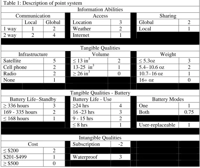
I have created a formula to score the usefulness of information enabling devices
for use in the backcountry. The formulas are based on a point system: devices will gain
points by exhibiting certain features, or based on where some measurable property of the
device falls on a scoring chart. Higher scores are better. The formula is as follows:
Total Score = information abilities + tangible qualities + intangible qualities Each of these score components can be broken down further. In order to determine the
Information abilities = infrastructure x (communications + access + sharing) Tangible qualities = volume + weight + battery
Intangible qualities = durability + cost + subscription The battery score can be expanded to this form:
Battery = (mode multiplier x (use hours + standby hours)) + type
Scoring will be computed according to the following possible values for the variables in
the aforementioned equations:
Table 1: Description of point system
Information Abilities
Communication Access Sharing
Local Global Location 3 Global 2
1 way 1 2 Weather 2 Local 1
2 way 2 4 Internet 1
Tangible Qualities
Infrastructure Volume Weight
Satellite 5 ≤ 13 in3 2 ≤ 5.3oz 3
Cell phone 2 13-25 in3 1 5.4 – 10.6 oz 2
Radio 2 ≥ 26 in3 0 10.7 – 16 oz 1
None 1 16+ oz 0
Tangible Qualities - Battery
Battery Life – Standby Battery Life - Use Battery Modes
≥ 336 hours 3 ≥24 hrs 4 One 1
169 - 335 hours 2 16 -23 hrs 3 Both 0.75
≤ 168 hours 1 9 - 15 hrs 2
≤ 8 hrs 1 User-replaceable 1
Intangible Qualities
Cost Subscription -2
≤ $200 2
$201-$499 1 Waterproof 3
≥ $500 0
Now, allow me to explain the rationale behind point distribution. The first consideration
for local or one-way features, 2 points for two-way or global features. Ideally, a device
that enables two way communications between two or more parties located any distance
from each other is optimal. Thus, global two way communications are awarded four
points (2 points for two-way communication x 2 points for global communication.) One
way global communication is equally as valuable as communicating bi-directionally
within a limited distance. From the perspective of benefit to the user: the ability to
transmit a message to anyone, anywhere, at least provides them with some kind of
information – an all clear message or a distress signal upon which they can act. The
drawback to this is that information cannot be returned, or the person contacted may be
too far removed to help. Regarding local communication, the ability to have a
conversation is valuable, provided there is someone available to respond. Without a
response the value provided by two-way communication is negated. The formula reflects
this, showing that one way global communication earns 2 points (1 point for one-way x 2
points for global) as does two-way local communication (2 points for two-way x 1 point
for local). Finally, one way local communication merits one point, as it is better than
nothing (1 point for one-way x 1 point for local).
The communication score is added to the access score, which is very
straight-forward. If the device enables access to current location, three points are awarded. If the
device enables access to weather information, two points shall be given. For access to
the internet, a device earns one point. A score of 6 is possible, if a device is able to
provide access to all three criteria. Other combinations are possible. The final
component of the base information score, before the infrastructure multiplier, is sharing
local information sharing, one point is added. Communication and sharing are calculated
as two different scores for the reason that communication is considered in the sense of
voice information and sharing in the sense of data. A hand-held radio, for example, will
enable communication, but the device itself does not necessarily share information. A
user could certainly relay information he generates about his location, but the device does
not have the ability to report that information on its own. Other devices, such as personal
locator beacons, do not enable communication. Rather, when these devices are activated,
they broadcast only the current location. No message is communicated. This distinction
may seem to be splitting hairs, however, I believe that it is necessary in order to fully
differentiate the features of some devices from others.
Finally, the complete information abilities score is determined by taking the sum
of the communications, access, and sharing scores then multiplying the result by the
infrastructure multiplier. The multiplier is determined based on the type of infrastructure
the device requires to communicate, access, or share information. Satellite infrastructure
is worth five points, because this type of infrastructure is accessible from nearly
anywhere in the backcountry. Cellular radio and radio-to-radio based infrastructures
come in next, earning two points. The final possible multiplier value is one point for no
functionality enabling the communication, access, or sharing of information. This
multiplier is included so that the value of older, analog devices could be scored in
addition to newer technologies. This component was formulated by considering that a
device is only as good as the network it operates on. The reason for the drastic gap in
points is to acknowledge that satellite technology is far more versatile, able to reach into
that operate over local radio frequencies are limited by the strength of the transmitter, and
also require a unit operating on the same frequency for them to be useful. The mobile
nature of local radio infrastructure is worth noting.
The tangible qualities score is based on physical qualities of the device. Because
users of the backcountry are limited in what they are able to carry with them, space and
weight become important factors when considering what goes in the pack and what stays
home. Devices are rewarded for being smaller and lighter, and lasting longer on a single
battery charge. In order to establish a baseline for these scores, I have used commonly
understood comparison items. As a reference for volume, devices will be compared to a
deck of playing cards. A deck is approximately 2.6 inches by 3.6 inches by 0.7 inches.
The total volume of a deck of cards is 6.55 cubic inches. Most backcountry users do not
object to carrying something the size of a deck of cards if it provides value. For simple
entertainment, most are willing to carry a deck of cards for long days in a tent. I have
doubled this size to determine the largest point total awarded. Two points for being equal
to or less than the space taken up by two decks of cards. One point is given if the device
occupies a volume between thirteen and twenty-six cubic inches, or up to the space
needed for four decks of playing cards. No points will be given for devices larger than
this. Again, I am not attempting to say that functionally, a deck of cards is the equivalent
of any device. Certainly, a deck of cards is useful. Its dimensions are discussed here
merely as a point of reference to which people can relate.
Similarly, I have provided a point of reference for the weight scoring. One liter of
water weighs 2.205 pounds. In the world of backcountry users, who often count ounces,
approximately one half liter of water (roughly one pound) will be used. A device
weighing in at less than one third of a pound (5.3 ounces) represents the maximum points
(3 points) given for the weight score. Two points are given for weighing between one
third and two thirds of a pound (10.6 ounces), and one point is given for being between
two thirds and one pound (16 ounces). Zero points are awarded for devices over 16
ounces.
Battery score factors into the tangible score as well. The longer a device is able to
last on its battery, the more points it will receive. The scoring for batteries is broken
down into two categories, standby time and use time. Some devices have both a standby
mode and active use mode. When this is the case, their score is multiplied by 0.75, as
their reported times are exclusive and do not account for mixed usage, i.e. using the
device actively part of the time and in standby mode for the remainder of the time. In
this way, devices that operate in only one mode are not penalized for not having a
standby mode. Battery life time score criteria were established by looking at the
manufacturer specifications for devices popular today. Most devices are able to operate
in standby mode for approximately two weeks, or 336 hours. 3 points are awarded for
achieving this. If the device is capable of operating in standby mode for one to two
weeks (168-336 hours) then 2 points are given. For any duration of time less than this, a
device shall receive one point. In full power, full use mode, the ideal range is anywhere
from 10 to 24 hours. The maximum points possible for use are determined in a fashion
similar to the standby scoring. For use of 24 hours or more, 4 points shall be earned. 16
to 23 hours is worth 3 points, 9 to 15 hours worth 2 points, and less than 9 worth 1 point.
user-replaceable, then 1 point will be added to the device’s score. This is to acknowledge the
benefit provided by devices that use batteries which the user could replace by carrying
spares, if they so desire. While devices without removable batteries can be recharged by
the use of devices such as portable solar chargers or battery packs, these devices take up
additional space and weight that this equation does not account for.
The final component of the score is the intangible qualities score. Factors such as
whether or not the device is waterproof, its cost, or if it requires a subscription are all
factors that will add (or subtract) from the intangible score. A device that is built to
withstand exposure to water earns 3 points. If a subscription is required for the device to
be useful, there is a penalty of -2 points. Points for cost are awarded on a scale, with
devices which cost under $200 being awarded 2 points. Devices that cost between $200
and $500 will receive 1 point, while any device that costs more than $500 will not be
granted any points. This is to reward devices that are affordable.
Evaluation
Now, considering the different kinds of information needs that one might
encounter in the backcountry, five of today’s information devices were selected and
evaluated with the aforementioned formula to determine which of them are best suited to
fulfill those needs. The devices selected were chosen because of their presence in
popular outdoor recreation magazines or other media. The devices are marketed as
solutions to information needs identified in this paper. The devices represent five distinct
approaches to the information needs: radio based coordination, cellular communication,
satellite communication, personal location, and hybrid satellite communication/personal
manufacturer’s documentation, qualitative evaluations were done to evaluate the
perceived ease of use and the perceived usefulness of these products. Because ease of
use and usefulness are perceived, and thus subjective, there is no score for these fields.
Results
Garmin Rino 530HCx
This GPS-enabled walkie-talkie allows users to wirelessly share data, in addition
to providing access to topographical maps, barometric altimeter, NOAA weather reports,
and a digital compass on screen to help users orient themselves (Garmin, 2009). Its most
important feature is its
ability to share data
wirelessly with other
similar units. This feature
may not be useful for the
solo adventurer out under
normal circumstances,
and perhaps other
handheld GPS units
would be more beneficial
and less expensive.
However, the Rino does
enable the sharing of
coordinates for multiple parties or routes. This device excels in search and rescue
applications, and thus is included in this study. This is a GPS unit that differentiates itself Table 2: Scorecard for Garmin Rino 530HCx
Criteria Score Justification
Information
1. Infrastructure 2 Radio
2. Communication 2 2 way; local
3. Access 5 Location, weather
4. Sharing 1 Local
Tangible
5. Volume 0 31.05 in3
6. Weight 2 10.3 oz
7. Mode 1 One mode
8. Battery Life Use 2 14 hours 9. Battery Life Standby 0 N/A
10.Battery Type 1 User-replaceable
Intangible
11.Durability 3 Waterproof
12.Cost 1 $499
13.Subscription 0 No
Total
from other units by not only providing mapping information but also access to the
location of other units. Coordination of dispersed group activities in the backcountry
becomes much easier with a device such as the Rino.
GPS functionality is certainly no replacement for a map and map reading skills.
Additionally, there is the obvious consideration that maps do not require battery power
that can be exhausted. However, GPS units are definitely a tool that provides value by
helping people safely find their way around the backcountry, and in the case of the Rino,
by helping rescuers to conduct more efficient searches. When completing the scorecard
for the Rino, it received points for operating on a radio infrastructure. Although the Rino
uses GPS to acquire its location, it does not communicate over a satellite network, so thus
it was scored accordingly. Also, it is worth noting that the device itself is not
outlandishly large, as its score might suggest. Rather the antenna required for GPS
functionality and radio based communications led to a larger than normal measurement of
the device’s volume. Complete device measurements may be found in appendix D. The
manufacturer reports no differentiation of power settings. There are two barriers to
adoption of this particular technology. The first is simply cost. The second is that
multiple units are needed to make its value apparent. While the Rino can always obtain
GPS information, location sharing works only with other Rino units. The radio bands the
walkie-talkie operates on is standard, so the device can always talk to other hand-held
walkie-talkies. The bands are Family Radio Service (FRS), an unlicensed set of
frequencies that offers a range of up to five miles, and General Mobile Radio Service
The perceived usefulness of this device for the solo adventurer is low. There are
less expensive models with more features for the individual out there. However, for
search and rescue the usefulness is high. Perceived ease of use falls somewhere in the
middle: basic operation seems easy enough, although using some of the more advance
features such as position reporting may not be obvious.
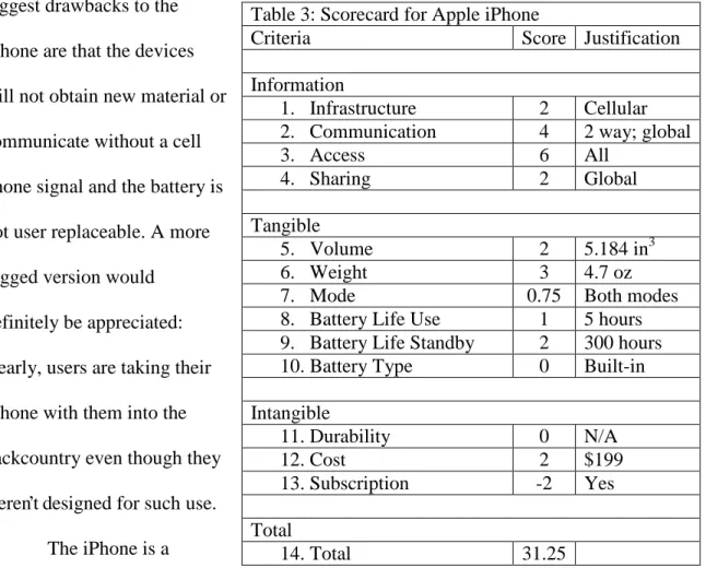
Apple iPhone
Before discussing the scoring or the perceptions of this device, its potential has to
be acknowledged. The potential of this device is extensive, largely because of its
versatility. Because it is an embodiment of most of the technologies listed above in one
small package, the number of things that can be accomplished with the iPhone is
impressive. While simply having an iPhone doesn’t enable someone to walk into the
woods and survive, the device can be leveraged by just about anyone to make his trip
more enjoyable. For example, the iPhone can embed GPS coordinates in the metadata
attached to photos so that the user can virtually map out their trip when they return to
civilization (Apple, 2009). It has the ability to replace multiple books as well, as eBooks
are available for the iPhone (Amazon, 2009). Books are both space and weight intensive,
and the ability to take a few hundred books with you could be quite valuable, as you
could carry field guides, first aid instruction, travel guides, and leisure reading without
taking up valuable space in the pack. Through GoogleEarth and the iPhone’s built-in
GPS, mapping results similar to the Garmin Colorado may be achieved.
There are other applications for the iPhone too, uses which may have previously
been too obscure to merit development of a specific tool. As an example, an application
audio samples of songs playing and then, after analyzing the sample and creating a
unique footprint, check it against a database of known songs to identify it. On the
downside, the Shazam application requires music playing through speakers somewhere to
identify – not likely in the backcountry. But what someone might hear in the backcountry
is birds. iBird (Waite, 2009) is an application made with its database built in. This
application references photos and sound clips of the calls of all the birds in North
America. By recording a bird call on the iPhone, it can then be checked against the
database to identify the bird. Such technology could be used by anyone outside to
identify any sound they do not know – the call of an owl, or a wolf howling at the moon.
This notion could be taken a step further: add in the geotagging abilities of the
phone, and you now have a device that can record the call of an animal, identify the
animal based on its unique vocal footprint, and place the animal in a given area at a given
time. This information could be helpful in data collection of information on species
about which little is known or that are currently under observation. This is the first
device that is incredibly versatile and not built specifically for just one purpose that could
be used in the backcountry. It enables a huge variety of what could be important
information uses in the backcountry, if people are willing to encourage its use in the
backcountry. This is a device that merits watching. As mentioned before, in 2004,
Eagles suggested that such a device that combined all the features of the iPhone would
come to exist in the medium term.
There are tradeoffs, however. The iPhone’s camera sports only two megapixels
whereas some other purpose built cameras with geotagging abilities have a thirteen
difference between spotting BigFoot and just a hairy man out for a stroll. Also, the
screen is smaller and the battery life not as good as some eBook readers. Seemingly a
jack of all trades, master of none, Apple has come very close to being both. The two
biggest drawbacks to the
iPhone are that the devices
will not obtain new material or
communicate without a cell
phone signal and the battery is
not user replaceable. A more
rugged version would
definitely be appreciated:
clearly, users are taking their
iPhone with them into the
backcountry even though they
weren’t designed for such use.
The iPhone is a
departure from traditional outdoor devices. Operating it in cold weather could become
problematic. Apple lists -4° F as a non-operating temperature, and using the touchscreen
with thick gloves could be difficult. Perceived ease of use tends towards easy, although
adapting to interacting with the device via the touchscreen, its only method of input, may
take some getting used to. Usefulness may be somewhat hampered by connectivity
issues, but even without a cell signal, the device is quite versatile. Table 3: Scorecard for Apple iPhone
Criteria Score Justification
Information
1. Infrastructure 2 Cellular
2. Communication 4 2 way; global
3. Access 6 All
4. Sharing 2 Global
Tangible
5. Volume 2 5.184 in3
6. Weight 3 4.7 oz
7. Mode 0.75 Both modes
8. Battery Life Use 1 5 hours 9. Battery Life Standby 2 300 hours
10.Battery Type 0 Built-in
Intangible
11.Durability 0 N/A
12.Cost 2 $199
13.Subscription -2 Yes
Total
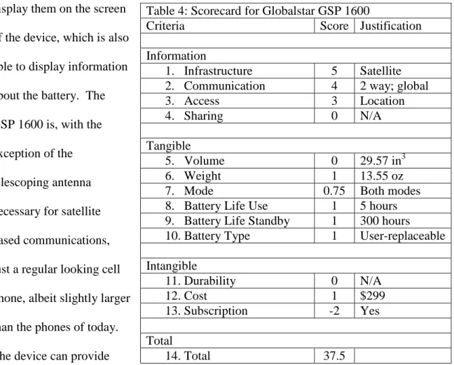
Globalstar Qualcomm GSP 1600 Handheld Phone
Combining standard terrestrial cellular communications with satellite abilities
produces the Globalstar Qualcomm GSP 1600 Handheld phone. This is a device that is
able to use cell phone signals where available to conserve battery and switch to a satellite
signal once the user travels beyond the reach of cell service (Globalstar, 2009). It is able
to send text messages via the Short Message Service and to receive GPS coordinates and
display them on the screen
of the device, which is also
able to display information
about the battery. The
GSP 1600 is, with the
exception of the
telescoping antenna
necessary for satellite
based communications,
just a regular looking cell
phone, albeit slightly larger
than the phones of today.
The device can provide
internet connectivity to devices such as laptops or PDAs through the use of a data cable,
but it is not able to connect to the internet on its own. As such, it is scored only as having
access to current location. Also, the volume measure is just outside of the largest scoring Table 4: Scorecard for Globalstar GSP 1600
Criteria Score Justification
Information
1. Infrastructure 5 Satellite
2. Communication 4 2 way; global
3. Access 3 Location
4. Sharing 0 N/A
Tangible
5. Volume 0 29.57 in3
6. Weight 1 13.55 oz
7. Mode 0.75 Both modes
8. Battery Life Use 1 5 hours 9. Battery Life Standby 1 300 hours
10.Battery Type 1 User-replaceable
Intangible
11.Durability 0 N/A
12.Cost 1 $299
13.Subscription -2 Yes
Total
bracket, so the device, although receiving the same amount of points for this measure, is
not nearly as big as the Garmin Rino.
The GSP seems very easy to use. Simply turn it on, extend the antenna, and dial
the number you wish to call. Its usefulness is undeniable: it does not require a cell signal,
simply a clear view of the sky. On the downside, service plans can be expensive if the
provider is not offering any promotion pricing, and the phone is not waterproof.
McMurdo Fast Find 210
The McMurdo Fast Find 210 is a Personal Locator Beacon (PLB) with no frills.
It is a worst case scenario communications device. It does not, in the strictest sense,
enable the transmission of messages in any way. When the device is activated, it
connects to the International Satellite System for Search and Rescue known as
Cospat-Sarsat (The acronym Cospat is in Russian, “Cosmicheskaya Sistyema Poiska Avariynich
Sudov” which means Space System for the Search of Vessels in Distress”; Sarsat stands for
Search And Rescue Satellite Aided Tracking). Cospas-Sarsat (2009) defines their system
thusly:
Cospas-Sarsat is a satellite system designed to provide distress alert and location data to assist search and rescue (SAR) operations, using spacecraft and ground facilities to detect and locate the signals of distress beacons operating on
406 Megahertz (MHz). The position of the distress and other related information is forwarded to the appropriate Search and Rescue Point of Contact (SPOC) through the Cospas-Sarsat Mission Control Center (MCC) network. The goal of the System is to support all organizations in the world with responsibility for SAR operations, whether at sea, in the air or on land.
Since 1982, the Cospas-Sarsat system has been used to save over 24,000 lives worldwide
(Cospas-Sarsat, 2009). The activation of a PLB on the Cospas-Sarsat system indicates
need to share information about his location with third parties around the globe. The Fast
Find does not actually provide the user with any information. Its access score reflects
this. Since the infrastructure the device requires is satellite based, it is able to effectively
communicate anywhere
around the world with a view
of the sky. However, the Fast
Find is a device that is carried
and goes unused until all other
avenues of self-rescue have
been exhausted, and
hopefully, its use is never
needed. It provides no
functionality other than to
alert the appropriate point of
contact of the user’s location,
and then actively advertize
their location via both the primary 406 MHz signal and a secondary 121.5 MHz homing
signal until its battery runs out (McMurdo, 2009).
The perceived usefulness of the Fast Find presents a difficult situation. The odds
of actually needing the device are low, and therefore it would be easy to say that the
perceived usefulness of it is low, since on a day to day basis it will not be used.
However, the Boy Scouts of America warn everyone to be prepared, and for that, the Fast
Find is very useful. When the situation becomes dire, that battery on the Fast Find will Table 5: Scorecard for McMurdo Fast Find 210
Criteria Score Justification
Information
1. Infrastructure 5 Satellite
2. Communication 1 1 way; global
3. Access 0 N/A
4. Sharing 2 Global
Tangible
5. Volume 2 10.34 in3
6. Weight 3 5.3 oz
7. Mode 1 One mode
8. Battery Life Use 4 24 hours 9. Battery Life Standby 0 N/A
10.Battery Type 0 Built-in
Intangible
11.Durability 3 Waterproof
12.Cost 1 $299
13.Subscription 0 No
Total
not be dead because you called home last night to tell your mother what you ate for
dinner. It is also very easy to operate. A user must simply remove the antenna cover,
deploy the antenna, and press the ‘On’ button. Once activated, the unit will continue to
operate until the battery runs out, so even if the user is not functioning, the Fast Find is.
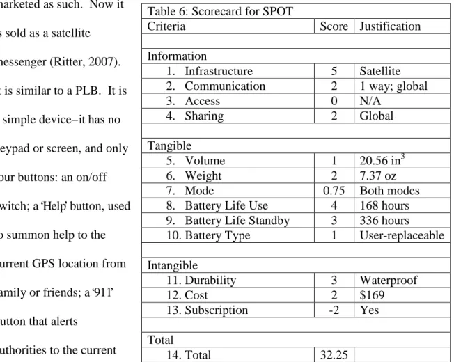
SPOT Satellite Messenger
SPOT is a satellite based communications device. Originally the acronym stood
for “Satellite Personal Tracker”, where the “O” was an earth. However, due to concerns that
it was actually a tracking device that could be used for nefarious purposes, it is no longer
marketed as such. Now it
is sold as a satellite
messenger (Ritter, 2007).
It is similar to a PLB. It is
a simple device – it has no
keypad or screen, and only
four buttons: an on/off
switch; a ‘Help’ button, used
to summon help to the
current GPS location from
family or friends; a ‘911’
button that alerts
authorities to the current
location and that the user is in distress; and an ‘Ok’ button that can send a message to
family or friends or update GoogleMaps with the current location. This feature provides Table 6: Scorecard for SPOT
Criteria Score Justification
Information
1. Infrastructure 5 Satellite
2. Communication 2 1 way; global
3. Access 0 N/A
4. Sharing 2 Global
Tangible
5. Volume 1 20.56 in3
6. Weight 2 7.37 oz
7. Mode 0.75 Both modes
8. Battery Life Use 4 168 hours 9. Battery Life Standby 3 336 hours
10.Battery Type 1 User-replaceable
Intangible
11.Durability 3 Waterproof
12.Cost 2 $169
13.Subscription -2 Yes
Total
peace of mind for every mother who worries about the safety of her child (full grown or
otherwise) who has run off into the backcountry. Despite Orwellian concerns (Shultis,
2001), some people would be more than willing to use this technology.
The SPOT’s capabilities make it a valuable tool for all categories of backcountry
users since any SPOT device can be used to check in or request help. Since the
technology is satellite based, there is no concern about cell phone signal reception, or the
intrusion of antenna installations on undeveloped land. The drawback is the limited
nature of the communications it enables. It only allows for one way communication.
The SPOT cannot receive messages or warnings, and all of the generated outgoing
messages sent are preset. For example, there is no way to differentiate between a broken
leg and a heart attack, which would be useful information to responders. Management
uses are minimal (outside draconian, Big Brother-type uses where all park visitors would
be required to carry one so that administrators could track all movements). That being
said, rangers could be outfitted with a SPOT in the event of a worst-case scenario. Both
administrators and responders, though, gain access to information regarding adventurer
distress signals, which greatly facilitates emergency response. This is an improvement
upon systems in use today. Currently, best practice in place suggests leaving a third party
as much information about your trip as possible. This third party is responsible for
reporting an adventurer late if they do not check in appropriately. This system is flawed,
however, because many times the third party is able to rationalize their concerns away.
By the time authorities are alerted, it is often times too late. Additionally, many times,
good example of this. Had the young man shared his plans with anyone else, he might
not have been forced to amputate his own arm (Brick, 2009).
For the purposes of the scoring formula, the manufacturer provided data for 911
Emergency mode was used for battery life time for use. The calculation for standby
mode was based on the SPOT’s tracking mode battery performance. Also, the SPOT did
not receive any points for access qualities, much like the Fast Find. The SPOT has no
screen or any other means of reporting this information back to the user. The perceived
usefulness of the device could vary, depending on the individual needs of the user. For
someone who needs to check in regularly, the usefulness is high. For those with less ties
back to civilization, usefulness may be low. The perceived ease of use is easy, as there
are only 4 buttons on the device, and functionality seems straightforward.
Limitations
The limitations of these current technologies are several, and mostly related to
connectivity. For example, while the SPOT is able to connect to its service nearly all
over the world wherever the user has a clear view of the sky, it is unable to send
messages other than its location and an all clear or one of two requests for help. On the
other hand, the iPhone is a fully-featured communications device. It is capable of phone
functionality, sending emails, short message service (SMS) text messages, and high speed
data transfer rates for internet access. However, unless the device is within the range of a
cellular phone tower, these features are worthless. That’s not to say the device is rendered
useless: there is still the built in GPS functionality. But if one is carrying a GPS unit in
the backcountry, it should communicate with other units regardless of cell signal, which