JOURNAL OF FOREST SCIENCE, 55, 2009 (4): 171–176
Roads are essential structures to provide access to the forest from the establishment phase to the harvesting stage. Thus it is important that roads are properly planned in order to ensure the transport of forest products and safety, comfort and economy of vehicle operations (Abeli et al. 2000). Road planning and development for operational forest harvesting are an important component of the forest manage-ment process (Murray 1998). The planning of a road network to access timber harvest sites is a dif-ficult and time-consuming task. By evaluating alter-native routes in the office using available Geographic Information System (GIS) routines, days or even weeks of valuable field time can be saved and ulti-mately, a better design may emerge (Rogers 2001, 2005). The viability and profitability of operational forest management plans is very much influenced by road costs as well as road network structure (Kirby et al. 1986). Given the importance of these costs, finding cost effective paths for new road networks is highly desirable (Dean 1997). Road networks are often developed by engineers using contour and thematic maps (Liu, Sessions 1993; Rogers 2005; Picard et al. 2006). Several automated procedures
using network techniques have been developed to improve road planning (Chung et al. 2004; Epstein et al. 2006). With the popularity of GIS in natural resource management and increasing access of forest engineers to desktop GIS software, efforts are being made to integrate traditional road design techniques into GIS. The use of the PEGGER to identify path-ways of acceptable road gradient is one such software (Rogers 2001). In the case of forest roads several criteria may need to be evaluated to choose the best alternative. Such procedures are called Multi-criteria Evaluation (MCE). One of the most common proce-dures for multi-criteria evaluation is Weighted Lin-ear Combination (WLC). WLC is straightforward in a raster GIS (Eastman 1995). Development of the relative importance of factors is an important stage. Although a variety of techniques exist for the development of weights, one of the most promising is that of pair-wise comparison developed by Saaty in the context of a decision-making process known as the Analytic Hierarchy Process (AHP) (Eastman 1995). In road planning different kinds of criteria often exist, particularly with environmental factors. Coulter et al. (2003) stated that AHP provides a
A GIS-MCE based model for forest road planning
E. Abdi
1, B. Majnounian
1, A. Darvishsefat
1, Z. Mashayekhi
1, J. Sessions
21
Faculty of Natural Resources, University of Tehran, Karaj, Iran
2
Department of Forest Engineering, Oregon State University, Oregon, U.S.A.
ABSTRACT:One of the cost factors in forest management is the development of road infrastructure. The objective of study was to develop a method using GIS and Multi-criteria Evaluation (MCE) to design a forest road network with the lowest construction cost while maintaining other technical requirements. Six road alternatives meeting technical requirements were developed using PEGGER. Then MCE was used to evaluate the construction costs of the candidate networks. The decision making group identified six factors as being relevant to the costs of forest roads. Then factors were compared in a pair-wise comparison, in the context of the Analytic Hierarchy Process to develop weights of map layers. Then weights and factors were entered into the MCE module to create a final suitability map. The total cost of each alternative was extracted from the suitability map and the unit cost of each alternative was calculated. The results showed that alternatives one and two had the highest and lowest unit costs, respectively. The results illustrated the utility of using GIS and MCE to improve the planning process.
useful framework to provide quantitative measures of environmental benefits of forest road mainte-nance. Also Coulter et al. (2006) stated that AHP has the potential to provide a consistent approach to the ranking of forest road investments based on multiple criteria. AHP was specifically developed to provide a consistent, quantifiable approach to problems involving multi-criteria analysis. Shiba (1995) used AHP to identify the benefit structure of a road network and showed that AHP is a particularly useful tool for resolving political, economic and en-vironmental conflicts. The first introduction of this technique to a GIS application was that of Rao et al. (1991). In the procedure for MCE using a WLC it is necessary that the weights sum to one. In Saaty’s technique, weights of this nature can be derived by taking the principal eigenvector of a square recipro-cal matrix of pair-wise comparisons between the criteria. The comparison concerns the relative im-portance of the two criteria involved in determining suitability for the stated objective. Ratings are pro-vided on a 9-point continuous scale. The magnitude of the decision makers’ inconsistency in completing pair-wise comparisons is measured using a consist-ency ratio (CR). Saaty indicates that matrices with CR ratings greater than 0.1 should be re-evaluated
(Eastman 1995). The objective of this study was to develop a model to design and evaluate forest road networks with regard to technical requirements and costs using GIS and MCE. The process must inte-grate into existing desktop software, incorporate the knowledge of the road engineer and be simple and easy to understand and use.
MATERIALS AND METHODS
Study site
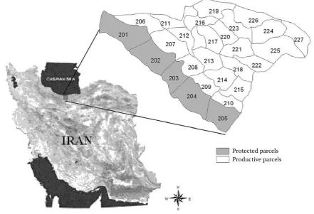
[image:2.595.77.519.443.744.2]The study site is situated in Mazandaran province, south of the Caspian Sea, in Iran (latitude 36°29'N, longitude 50°33'E) (Fig. 1). The research was per-formed in Namkhane district, which covers 788 ha and has 22 compartments (excluding 5 protected compartments). The system of management is the selection system and is followed to ensure sustain-able development and sustained yield. This region has a temperate climate and rainfall is distributed throughout the year. Elevation is 310 to 1,345 m above sea level and slope varies between 0 to 80%. The existing road density (RD) is 14.6 m/ha, which with regard to the selection management system is not sufficient (Iranian Plan and Budget Organization
Fig. 1. Study area
2000), thus additional roads need to be designed and constructed.
METHOD
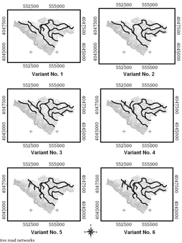
First, the contour line layer was extracted from 3D DGN files and was used to generate a digital eleva-tion model and also to design road alternatives. The divider setting method was used for plotting a grade line on a contour map. The preliminary road corri-dors can be checked by this method on topographic maps (Elias 2001; Rogers 2005). An ArcView GIS extension called PEGGER (Rogers 2005), which au-tomates the route projection, was used to design six road network alternatives with regard to forest road
[image:3.595.117.481.54.538.2]standards. Then, MCE was used to evaluate the al-ternative road networks with regard to construction costs. The first step in multi-criteria evaluation was establishing the criteria. The decision-making group identified six factors as being relevant to forest road construction costs: slope, soil, geology, aspect, alti-tude and standing volume. There are other important factors, such as hydrologic condition, but their layers were not available so they were not included in the study. The factors were standardized to a consistent range of 1–5. In addition, all factor layers were devel-oped so that low values would indicate more suitable areas. The next step was to establish a set of weights for each of the factors. The forest road engineers as a group of decision makers were asked to fill out a
pair-wise matrix. Each decision maker was asked to estimate a rating and explain why he felt that way. Then the geometric mean was used to incorporate the ratings of decision makers (Aczel, Saaty 1983). After the pair-wise comparison matrices were com-pleted, the inconsistency and weights were derived using the eigenvector method (Saaty 2000; Coul-ter et al. 2003). Then the factors were combined in the form of a weighted linear combination:
n s =
∑
WiXii
where:
Wi, Xi – the ith factor weight, ith factor – criterion score, respectively.
Therefore a single index of evaluation was formed where low values would indicate more suitable zones. Total values of each road network were ex-tracted from a suitability map. Then, the unit cost of each network was calculated by dividing each network total cost by its length.
RESULTS AND DISCUSSION
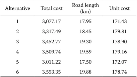
Using PEGGER, it was possible to analyze many different road location alternatives over a large geographic area in a short amount of time (Rogers 2005). Minimum and maximum length of alterna-tives were 17.50 and 19.88 km, respectively (Fig. 2).
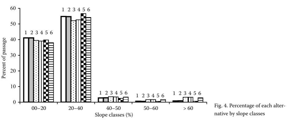
[image:4.595.64.288.61.128.2]The results of AHP showed that slope and standing volume had the highest and the lowest weights, respectively (Fig. 3). The consistency ratio was 0.06 and acceptable (Eastman 1995). The total and unit costs of each road alternative were extracted from the suitability map (Table 1). The results showed that alternatives 1 and 2 had the highest and the lowest unit costs, respectively, thus alternative 1 had the highest suitability. Terrain slope has the highest weight in the suitability rating. Since alternatives 1 and 5 passed through slopes greater than 40% less frequently in comparison with other alternatives (Fig. 4), they had lower construction costs with regard to slope gradient. Land evaluation and allo-cation were among the most fundamental activities of resource development. With the advent of GIS, we now have the opportunity for a more explicitly reasoned land evaluation process (Eastman 1995). Forest engineers often need to make decisions that satisfy several objectives, so one of the most useful models may be MCE. Using MCE, qualitative and quantitative criteria can be used and incorporated in decision making (Eastman 1995). In addition, all GIS software systems provide the basic tools for using the MCE model. The use of GIS in forest road planning offers a number of advantages over traditional methods. Using maps alone to determine routes is tedious and time consuming. On the other hand, a good model for road planning and choosing between alternative routes should incorporate the knowledge of the road engineer and be simple and easy to understand and use. Dean (1997), Huang et al. (2003) and Murthy (2003) used the Least Cost Path model for route selection. Although the path tool minimized the cost, it could not restrict passing through infeasible gradients. These paths have to be re-examined to provide suitable gradients
[image:4.595.65.542.564.770.2]Fig. 4. Percentage of each alter-native by slope classes
Fig. 3. Calculated factor weights using AHP Inconsistency ratio = 0.06 Slope .444
Soil .247 Geology .161 Aspect .080 Altitude .044 Volume .025
0 10 20 30 40 50 60
00-20 20-40 40-50 50-60 >60
Slope classes Pe rc en t o f p as sa ge
1 2 3 4 5 6
1 2 3 4 5 6
1 2 3 4 5 6 1 2 3 4 5 6
1 2 3 4 5 6
00–20 20–40 40–50 50–60 > 60
with regard to forest road standards. Mathematical programming models can include constraints to avoid infeasible gradients but they are more com-plex, and may not integrate the knowledge of the forest engineer.
CONCLUSION
This paper has presented a quantitative approach to selecting a forest road network using GIS and MCE. The capabilities of GIS in spatial analysis enable the planner to combine different factors and identify fac-tors that may improve the results. The use of AHP permitted the derivation of relative weights. The method described here is good for initial planning. However, the results from the model depend upon data precision. Future work could incorporate envi-ronmental factors into the model. This would allow the manager to incorporate construction costs and environmental factors together in route evaluation and selection.
References
ABELI W.S., MEILUDIE O., KACHWELE R., 2000. Road alignment and gradient issues in the maintenance of log-ging roads in Tanzania. International Journal of Forest Engineering, 11: 22–29.
ACZEL J., SAATY T.L., 1983. Procedure for synthesizing ratio judgments. Journal of Mathematical Psychology, 27: 93–102.
CHUNG W., SESSIONS J., HEINIMANN H.R., 2004. An ap-plication of a heuristic network algorithm to cable logging layout design. International Journal of Forest Engineering, 15: 11–24.
COULTER E.D., SESSIONS J., MICHAEL W.G., 2003. Sched-uling Forest Road Maintenance Using the Analytic Hierar-chy Process and Heuristics. Silva Fennica, 40:143–160. COULTER E.D., COAKLEY J., SESSIONS J., 2006. The
ana-lytic hierarchy process: A tutorial for use in prioritizing
forest road investments to minimize environmental effects. International Journal of Forest Engineering, 17: 51–70. DEAN D.J., 1997. Finding optimal routes for networks of
har-vest site access roads using GIS-based techniques. Canadian Journal of Forest Resources, 27: 11–22.
EASTMAN J.R., 1995. Decision Support. In: Idrisi for Win-dows: User’s guide version 1.0. Clark Labs for Cartographic Technology and Geographic Analysis. Clark University, Worcester, Mass: 10.1.10.6.
ELIAS G.B., 2001. Guidelines for low impact forest roads. Bureau of Forest Management Project, Indonesian Ministry of Forestry: 47.
EPSTEIN R., WEINTRAUB A., SESSIONS J.B., SESSIONS J., SAPUNAR P., NETO E., 2006. A combinatorial heuristic approach for solving real size machinery location and road design problems in forestry planning. Operations Research, 54: 1017–1027.
HUANG B., LONG C.R., YONG S.L., 2003. GIS_AHP model for HAZMAT routing with security considerations. IEEE 6th International Conference on Intelligent Transportation
System. Shanghai, IEEE ITS Council: 1–6.
IRANIAN PLAN, BUDGET ORGANIZATION, 2000. For-est road Project Guidelines No. 148. 2nd Ed. Office of the
Deputy for Technical Affairs. Bureau of Technical Affairs and Standards. Iranian Plan and Budget Publication. (In Persian)
KIRBY M., HAGER W., WONG P., 1986. Simultaneous plan-ning of wildland management and transportation alterna-tives. Management Science and Studies, 21: 371–387. LIU K., SESSIONS J., 1993. Preliminary planning of road
systems using digital terrain models. International Journal of Forest Engineering, 4: 27–32.
MURRAY A.T., 1998. Route planning for harvest site access. Canadian Journal of Forest Research, 28: 1084–1087. MURTHY A.R., 2003. Selection of least cost paths for
extraction of forest produce using remote sensing and GIS. Map India Conference. New Delhi, GIS Develop-ment: 1–9.
PICARD N., GAZULL L., FREYCON V., 2006. Finding optimal routes for harvesting tree access. International Journal of Forest Engineering, 17:35–48.
RAO B.R., DWIVEDI R.S., VENKATARATNAM L., RA-VISHANKAR T., THAMMAPPA S., BHARGAVA G., 1991. Mapping the magnitude of sodicity in part of the Indo-Gangetic plains of Uttar Pradesh, northern India us-ing Landsat data. International Journal of Remote Sensus-ing, 12: 419–425.
ROGERS L., 2001. PEGGER & ROADVIEW – A New GIS Tool To Assist Engineers in Operations Planning. The Interna-tional Mountain Logging and 11th Pacific Northwest Skyline
Symposium, Seattle, University of Washington: 177–182. ROGERS L., 2005. Automating aontour-based route
[image:5.595.63.292.74.203.2]pro-jection for preliminary forest road designs using GIS. [MS Thesis.] Washington, University of Washington:87. Table 1. Calculated unit cost of road alternatives
Alternative Total cost Road length (km) Unit cost
1 3,077.17 17.95 171.43
2 3,317.49 18.45 179.81
3 3,452.77 19.30 178.90
4 3,509.74 19.59 179.16
5 3,011.22 17.50 172.07
SAATY T.L., 2000. Fundamentals of Decision Making and Priority Theory with the Analytic Hierarchy Process. Vol. VI. The AHP. Pittsburgh, RWS Publications: 478.
SHIBA M., 1995. Analytic hierarchy process (AHP) based multi attribute benefit structure analysis of road network
system in mountainous rural areas of Japan. International Journal of Forest Engineering, 7: 14–50.
Received for publication June 5, 2008 Accepted after corrections November 27, 2008
Corresponding author:
Ehsan Abdi, University of Tehran, Faculty of Natural Resources, P.O. Box 31585–3314, Karaj, Iran tel.: + 98 0261 222 3044, fax: + 98 0261 227 765, e-mail: [email protected]
GIS-MCE model pro plánování lesních cest
ABSTRAKT:Jedním z ekonomických faktorů lesního hospodářství je rozvoj infrastruktury cest. Cílem práce bylo vyvinout metodu plánování sítě lesních cest s využitím systému GIS spolu s multikriteriálním hodnocením (MCE) tak, aby došlo k minimalizaci nákladů na výstavbu a zároveň byly zachovány ostatní technické požadavky. Šest alternativ cest splňujících technické požadavky bylo vytvořeno pomocí nástroje PEGGER. Multikriteriální hodno-cení bylo poté použito pro vyhodnohodno-cení cenových nároků na takto navrženou síť. Řešitelský tým identifikoval šest faktorů, které jsou pro cenu lesních cest relevantní. Tyto faktory byly poté hodnoceny pomocí párového porovnávání v rámci metody AHP (analytický hierarchický proces) a byly vytvořeny váhy mapových vrstev. Váhy a faktory byly zpracovány v MCE modulu pro vytvoření konečného plánu přiměřenosti. Celkové náklady na každou z alternativ byly vypočítány z plánu přiměřenosti a byla vyčíslena jejich jednotková cena. Z dosažených hodnot vyplývá, že návrhy 1 a 2 měly nejvyšší, resp. nejnižší cenu. Výsledky práce zároveň ukazují, že využití GIS v kombinaci s multikriteri-álním hodnocením zlepší proces plánování.